Note: Descriptions are shown in the official language in which they were submitted.
CA 02525734 2005-11-04 '
-1-
AUTOMATIC CONTINGENCY GENERATOR
FIELD OF THE INVENTION
[0001] This invention relates to aircraft control systems, and more
particularly to such
control systems that provide for automatic control of an aircraft based on the
occurrence of
various in-flight contingencies.
BACKGROUND OF THE INVENTION
[0002] The failure of critical systems or components in aircraft requires
quick
corrective action. When manned or unmanned aircraft fly in FAA controlled
airspace, every
conceivable contingency must be calculated and validated prior to flight. FAA
rules require a
contingent route every few minutes into a flight. For long duration flights
this requires a
large number of routes.
[0003] For missions using unmanned air vehicles (UAVs), pilots must plot a
specific
route for the UAV to fly and build in precise responses that the aircraft must
make in the
event that a variety of contingencies occur. For example, if the UAV loses an
engine along
the route, flight control software must provide the UAV with a pre-planned
means for
returning to an airfield and landing safely. In addition; if the UAV faces a
minor emergency
or loss of communication, the mission plan must account for those events.
Mission plans are
built for a specific area, and once the aircraft is in the area, the pilots on
the ground can make
manual inputs as necessary without compromising the aircraft's ability to
respond to
contingencies. However, depending on the mission, the aircraft may need to
deviate from a
specific area and a specific route.
[0004] There is a need for a system and method that can automatically produce
alternative flight paths to allow the aircraft to respond to various
contingencies.
SUMMARY OF THE INVENTION
[0005] This invention provides an autonomous air vehicle including a flight
control
system and an automatic contingency generator for automatically determining a
contingent
air vehicle route for use by the flight control system in response to
contingencies experienced
by the air vehicle.
[0006] In another aspect, the invention provides a method of automatically
determining a route for an unmanned air vehicle, the method comprising the
steps of: (a)
identifying a destination point; (b) constructing a first vector from a
location of the aircraft to
the destination point; (c) determining if the first vector passes through a no-
fly zone; (d) if the
776714
CA 02525734 2005-11-04
-2-
first vector does not pass through a no-fly zone, using the first vector as a
new route; and (e)
if the first vector passes through a no-fly zone, constructing a second vector
from the location
of the aircraft to a tangent point on the no-fly zone, establishing a waypoint
near the tangent
point, constructing a third vector from a waypoint to the destination point,
determining if the
third vector passes through a no-fly zone, and repeating step (e) using
additional vectors until
a vector to the endpoint is constructed that does not pass through a no-fly
zone.
[0007] In yet another aspect, the invention provides an apparatus comprising
an air
vehicle including a flight control system, a first automatic contingency
generator for
automatically determining a contingent air vehicle route for use by the flight
control system
in response to contingencies experienced by the air vehicle, and a
communications device for
communicating with a control station, wherein the control station includes a
second
automatic contingency generator for automatically determining a contingent air
vehicle route
for use by the flight control system in response to a loss of communication
with the air
vehicle.
BRIEF DESCRIPTION OF THE DRAWINGS
[0008] FIG. 1 is a schematic representation of a system that includes
components
constructed in accordance with this invention.
[0009] FIG. 2 is a functional block diagram of an aircraft control system that
includes
the automatic contingency generator of the present invention.
[0010] FIG. 3 is a diagram of selected components of an aircraft control
system and
ground station that includes the automatic contingency generator of the
present invention.
[0011] FIG. 4 is a flow diagram that illustrates a method for generating
alternative
routes.
[0012] FIGS. 5 and 6 are schematic diagrams that illustrate the determination
of
alternative routes.
DETAILED DESCRIPTION OF THE INVENTION
[0013] This invention provides an automatic system for producing contingent
actions
to counter critical flight failures. The system is referred to as an
"Automatic Contingency
Generator" or ACG. In response to certain events, the ACG produces contingent
actions by
management of the total energy of the air vehicle. The energy can be managed,
given the
current wind conditions, to land the air vehicle at a runway within a glide
range. The ACG
control is designed to take control during critical flight failures such as
loss of an engine,
degraded modes of operation, and/or loss of a communications link. The ACG is
also
776714
CA 02525734 2005-11-04
-3-
designed to achieve safe landing in friendly terntory to eliminate loss of the
vehicle, reduce
collateral damage, and provide for maximum destruction of a vehicle that must
land in hostile
territory to prevent the loss of technology to enemy forces. In addition, the
ACG can
automatically generate alternative flight routes in response to in-flight
changes in mission
objectives.
[0014] Referring to the drawings, FIG. 1 is a schematic representation of a
system 10
including aircraft constructed in accordance with this invention. The system
includes a
plurality of unmanned air vehicles (UAVs) 12, 14 and 16. Each of the UAVs
carnes one or
more sensors for supplying information about an area under surveillance. The
UAVs can
communicate with a plurality of ground stations 18, 20 and 22, and a plurality
of satellites 24,
26 and 28. Communication links are provided among the various system
components to
achieve the desired functionality.
[0015] Each UAV includes a flight control and guidance system that is used to
maneuver the UAV along a flight route. In the system of FIG l, each of the
UAVs can
communicate with one or more satellites. Pilots located at the ground stations
can
communicate with the UAVs.
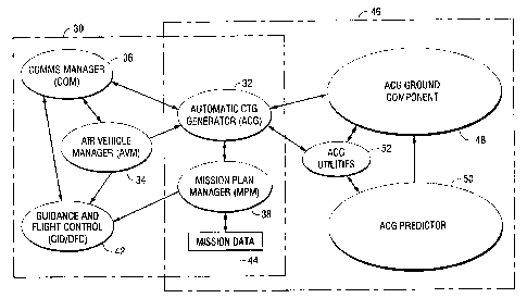
[0016] FIG. 2 is a functional block diagram of an aircraft control system 30
that
includes an ACG 32. The control system includes a plurality of sensors that
provide
information to an air vehicle manager 34, which is responsible for assessing
the mission
criticality of subsystem faults and declaring contingency levels. A
communications system
manager 36 is responsible for controlling and monitoring the air vehicle
communications
assets, and may declare a lost communications contingency if all links are
down. A mission
plan manager 38 provides data access to mission data including restricted
areas, special use
airspaces, runways, approach patterns, aggregated terrain data, forecast
winds, and alternate
ground control stations for re-establishing communications. The automatic
contingency
generator is responsible for integrating the fault state from the air vehicle
manager,
communications state from the communications system manager, and mission data
from the
mission plan manager, to build flight routes to return to the main operating
base or,
potentially, one of many possible divert bases, and uses a performance modeler
40 to validate
the route with respect to energy requirements, time, and fuel burned. The ACG
interfaces
with the vehicle guidance and flight control system 42 to control the
operation of the air
vehicle in event of a contingency. As the UAV flies the ACG generated route
under lost
communications conditions, the ACG continuously monitors air vehicle position
relative to
776714
CA 02525734 2005-11-04
-4-
the alternate ground stations, and automatically reconfigures communications
assets to
maximize the likelihood of re-establishing communications.
[0017] The ACG and mission plan manager can be duplicated in a ground control
station. FIG. 3 is a diagram of selected components of an aircraft and ground
station that
include the automatic contingency generator. As shown in FIG. 2, the aircraft
control system
30 includes the air vehicle manager 34, the communications system manager 36,
the mission
plan manager 38, the automatic contingency generator 32, and the guidance and
flight control
42. Mission data is loaded in the mission plan manager as shown by block 44.
The
automatic contingency generator 32 and the mission plan manager 38 can be
duplicated in the
ground station 46. The ground station also includes an ACG ground component
48, that
reads and accepts mission data, computes range rings, builds routes and lists
contingent
destinations. An ACG predictor 50 monitors lost communication time, updates
the air
vehicle state from air traffic control data, gets estimates of air vehicle
position, and gets the
current route of the air vehicle. ACG ground utilities 52 are used to provide
predictive
capabilities if the air vehicle communications fail, and construct routes for
what-if scenarios
to speed up system performance and enhance pilot situation awareness in the
ground station.
[0018] As shown in FIG. 3, the ACG software can exist both on the UAV and in a
mission control station that normally maintains communication with the UAV
from the
ground. When a pilot tells the UAV to go to a different location, both the
airborne ACG and
the ground element generate new routes. Consequently, if the UAV loses
communications
with the mission control while it is traveling on an alternate route, the
pilot will be able to
predict what the UAV will do next.
[0019] In the preferred embodiment, the system is used in an autonomous,
unmanned
air vehicle (UAV). The UAV is capable of autonomously performing a predefined
mission
without additional inputs. For example, the UAV can autonomously take off, fly
to a
designated area, perform reconnaissance operations, return, and land. During
the course of a
mission, the UAV can fly over a large area, that includes numerous airbases,
which can serve
as potential landing sites, and areas of restricted air space, referred to as
no-fly zones (NFZs).
The UAV may also communicate with a pilot, who can be in a ground control
station. The
pilot can make changes to the mission during flight of the UAV. These changes
may require
route changes that can be automatically generated by the ACG. Various
unplanned events
can also occur during a mission that can affect the mission.
776714
CA 02525734 2005-11-04
-5-
[0020] FIG. 4 is a flow diagram of the process used by the ACG to construct a
new
route. The process starts in block 60 by identifying the initial conditions
that must be
considered to generate a new route. These initial conditions include but are
not limited to the
starting position, the starting heading, the location of the destination,
current and forecast
winds, current energy state, and definitions of no-fly zones. Given these
initial conditions,
the ACG constructs an initial vector from the UAV position to the destination,
as shown in
block 62. Block 64 shows that the ACG then determines if there are any
occluding no-fly
zones between the UAV position and the destination. That is, does the initial
vector pass
through any no-fly zones? If occluding no-fly zones are present, the ACG
constructs a vector
from the UAV position to tangent points on the occluding no-fly zone as shown
in block 66.
Then a route to the destination is cloned for each tangent vector (block 68).
A cloned route
contains a copy of the base route, all route construction context data, and
the new vector to be
considered as a candidate next-step on the route. In constructing the tangent
vectors, the
ACG takes into account, the air vehicle performance parameters, climatologic
data or forecast
weather, and temporal constraints.
[0021] Next the ACG checks to determine if it has established a complete route
to the
destination, as shown in block 70. If the route is not complete, the ACG sets
a new vector as
shown in block 72 and repeats the steps in blocks 66 and 68. If the route is
complete, the
ACG checks to determine if the route is the shortest route, as shown in block
74. If it is the
shortest route, it is saved (block 76). Then the ACG checks to determine if
there are
additional routes to analyze, as shown in block 78. If not, the process ends
(block 80). If so,
the next route is selected for analysis as shown in block 82.
[0022] FIG. 5 is a diagram that further illustrates the elements and concepts
involved
in the route generation process. In the example illustrated in FIG. 5, the
mission starts with
the UAV at position 90. The UAV is programmed to follow an initial route
illustrated by
solid line 92. The initial route includes taxi positions 94, 96, 98 and 100
and a takeoff point
102. Predetermined waypoints 104, 106, and 108 are located between the takeoff
point and a
destination 110. Extirpation points 112, 114, 116 and 118 have been selected
along the initial
route. The initial route avoids no-fly zones 120 and 122. Assume that as the
UAV reaches
waypoint 106, a contingency occurs that requires the UAV to fly to a new end
point 124. To
reach the new end point, the UAV must construct a route to fly from waypoint
106 to the
initial approach fix (IAF) 126. To determine a new route, the ACG generates a
vector 128
from waypoint 106 to the IAF. Since this vector passes through both no-fly
zones, the UAV
776714
CA 02525734 2005-11-04
-6-
cannot follow this vector to the IAF. Thus the ACG must search for alternate
routes. The
search for alternate routes begins by generating vectors 130 and 132 to
tangent points 134
and 136 on the first no-fly zone 120. Candidate waypoints 138 and 140 are
established near
the ends of these vectors. The actual position of the waypoints can be a
predetermined
distance beyond the tangent points that depends upon the flight
characteristics of the UAV,
such as the turn radius.
[0023] When analyzing the proposed route that starts along vector 130, the ACG
generates a new vector 142 from waypoint 138 to the IAF. Since this new vector
passes
through no-fly zone 122, it cannot be used as a component of a new route.
Therefore, the
ACG generates a vector 144 from waypoint 138 to a tangent point 146 on no-fly
zone 122
and establishes a new waypoint 148. Then a new vector 150 can be generated
directly from
waypoint 148 to the IAF. A similar process would be performed for potential
routes that
follow each of the initial vectors that were generated to tangent points on
the no-fly zones.
Then the shortest route would be selected as the route to be used to fly the
UAV to the IAF.
From the IAF, the UAV would then proceed to waypoint 152, final approach fix
(FAF) 154,
touchdown point 156, and taxi points 158, 160 and 162 to reach the new end
point.
[0024] When approaching an airbase, the UAV will implement FAA standard hold
entry patterns for terminal geometry at all destinations, whether or not a
hold pattern will be
executed.
[0025] FIG. 6 is a diagram that illustrates the temporal sequence of steps
taken by the
ACG. In the example of FIG. 6, as the UAV travels along a route 170, the ACG
continually
determines new routes to alternative destination points. At points 172, 174,
176, 178 and
180, extirpation point 182 is selected as a destination to be used upon the
occurrence of a
critical emergency. Routes to extirpation point 182 are determined as the UAV
flies along
route 170. When the UAV reaches point 184, the ACG determines a new potential
destination point 186. Again routes to the new potential destination point are
determined as
the UAV files along route 170. If an emergency contingency event occurs when
the UAV is
at position 178, the UAV will be directed to fly to the IAF 190, using the
most recently
determined route to destination 186.
[0026] In the preferred embodiment, the ACG addresses three types of
contingencies:
lost communications contingencies, flight critical (system degradation)
contingencies, and
mission critical emergency contingencies. The lost communications contingency
is declared
when all communications are lost with all ground stations. In this
contingency, the air
776714
CA 02525734 2005-11-04
_7_
vehicle cannot operate under positive control, reducing the number of airbases
enabled for
operations. The ACG constructs a route following preplanned directions to one
of many
possible destinations designated for lost communications recovery. During
flight on the
ACG generated route, the ACG identifies alternative ground stations or
satellites which may
be used to re-establish communications, and automatically re-configures the
communications
system based on data included in the mission plan.
[0027] Time critical emergencies, including engine out and power system
failure
scenarios, are assessed continuously by ACG. The ACG uses the energy state of
the air
vehicle including: altitude relative to the ground, battery state, fuel state,
the status of flight
critical sensors and redundant control effectors (ailerons, elevators, rudder,
landing gear, and
engine). Energy state is used to determine the fly-out range of the air
vehicle, and is used to
identify candidate landing locations within range of the vehicle's current
position. If the
vehicle has insufficient energy to achieve any landing location, extirpation
points may be
preplanned into the mission data to provide a site where the vehicle may be
safely destroyed,
if operating in populated areas or in hostile airspace.
[0028] Mission critical emergencies, such as the loss of one or more redundant
actuators, or the loss of a crucial payload element, generally require the air
vehicle to return
to the main operating base or an alternative base. The ACG follows preplanned
directions,
which may include skipping loops on the current route or reversing on the
current route, to
shorten the mission and arrive at the destination in minimal flight time.
[0029] The ACG also considers combinations of the three contingency types. For
instance, an engine out scenario may also cause the loss of all
communications. In this
scenario, the list of candidate destinations for the time critical emergency
is reduced to those
that are also available for lost communications recovery.
[0030] Forecast wind data and actual winds are used to dynamically adapt all
routes
for wind effects on turn radius and vehicle climb/descent performance
capabilities, and
minimum fuel load required to execute the route. For example, 72 hour wind
forecast data
can be embedded in the mission plan, or may be uploaded to the aircraft during
flight.
[0031] This invention provides a method for production of automatic flight
paths to
recover from critical flight failures or off nominal conditions for air
vehicles both manned
and unmanned. The method can be used to reduce collateral damage from
unrecoverable
flight failures. The angle of landing can be adjusted depending on whether
extirpation point
is in friendly or hostile territory. Kinetic and wind energy can be leveraged
to glide to
776714
CA 02525734 2005-11-04
_g_
emergency landing areas automatically. Contingency calculations can be
performed during
flight.
[0032] The ACG removes the need to calculate the thousands of routes prior to
flight
and produces them only as needed or requested during flight. This reduces the
planning
required to fly an autonomous air vehicle in FAA controlled airspace due to
removal of the
requirement to calculate and validate every conceivable contingency prior to
flight. If a pilot
tells the UAV to go to a new destination, the ACG will build a new route,
taking into account
restricted airspace and other variables, and it prepares for what it will do
and where it will
land in the event it faces a major or minor contingency. Using the ACG, the
pilot's planning
time can be significantly reduced. The ACG lets the UAV respond to changes in
its orders in
mid-flight, devising a plan for what it will do in the case of a major or
minor contingency.
[0033] While the examples shown in FIGS. 5 and 6 show two-dimensional route
generation in longitude/latitude, the ACG actually performs the process in
four dimensions,
Longitude, Latitude, Altitude and Time. The ACG includes an elevation path
generator that
is used to generate the altitude profile based on air vehicle state, engine
state, and obstacle
clearance minimum altitudes based on standard Emergency Safe Altitudes (ESA)
and
Minimum Sector Altitudes (MSA) data available for most airbases, or may be set
based on
clearance altitudes available from air navigation charts. Adaptive elevation
management
adjusts the entire route, including the initial/final approach to compensate
for forecast wind
effects on air vehicle performance.
[0034] No-fly zones and approach routes are enabled and disabled as a function
of
time. For instance, a no-fly zone may be "hot" from 2:00 PM to 6:00 PM each
day, or an
airbase may be closed from 11:00 PM to 6:30 AM for noise abatement. As each
route is
built, expected arrival time is computed for each waypoint, no-fly zone, or
approach route.
Expected arrival times are compared to no-fly zone time spans (if defined),
and the route
generator must decide whether it is safe to fly through, or go-around the no-
fly zone based on
expected arrival. Approach routes with date/time restrictions are disallowed
if the UAV
cannot arrive at the approach within the available date/time restrictions.
[0035] Contingencies can be prioritized to make the destination selection and
route
generation. Under a normal approach, the UAV constructs a route to an approach
pattern.
Under a minimal approach, the UAV constructs a route (including approach) to a
designated
runway. Emergency runways can be used during climb/descent below lOK feet
above
776714
CA 02525734 2005-11-04
-9-
ground level. Extirpation points are added to provide impact points where
runways are
unavailable and impact on route is unacceptable.
[0036] Potential destination points can be selected using criteria which
include:
destination availability, priority, sufficient energy to clear obstacles,
sufficient battery time.
If no destination is available within the battery time, impact along the
current route can be
implemented. At each in-flight waypoint on the primary route, the mission
planner may
specify: continue on route (forward), reverse on route with left (RL) or right
(RR) turn, or
branch to a destination.
[0037] In a ground station, the ACG predictor predicts the most probable UAV
destination and routing during lost communications. The predictor uses air
vehicle state
information accrued to the point where communications are lost and predicts
the air vehicles
routing and ultimate destination. Provisions are made to allow predictor
resets by inputting
updated coordinates obtained via voice communications with air traffic
controllers. During
lost communications operation, the air vehicle automatically sets the IFF code
to 7600. If the
air vehicle has another in-flight emergency, transponder code is set to 7700,
and provisions
are made to allow an update to the air vehicle routing in the event of a time
critical
contingency as reflected by a change in air vehicle IFF squawk code.
[0038] While the present invention has been described in terms of several
embodiments, it will be apparent to those skilled in the art that various
changes can be made
to the disclosed embodiments without departing from the scope of the invention
as set forth
in the following claims.
776714