Note: Descriptions are shown in the official language in which they were submitted.
CA 02539591 2006-03-20
WO 2005/029001 PCT/CA2004/001734
- 1 -
METHOD AND APPARATUS FOR DETERMINING THE
POSITION OF AN UNDERWATER OBJECT IN REAL-TIME
CROSS -REFERENCE TO RELATED APPLICATIONS
[0001] This is the first application filed for the present
invent ion.
TECHNICAL FIELD
[0002] This invention relates to the field of robotics. More
precisely, this invention pertains to the field of
determining the position of an underwater remotely operated
vehicl a in real-time.
BACKGROUND OF THE INVENTION
[0003] As part of.a water dam security program, an underwater
remotely operated vehicle (ROV) has been under development
for the past few years. Such remotely operated vehicle may
be used in various inspection tasks taking place in
underwater environments. The vehicle is preferably used for
the inspection of dam surfaces, of rock concrete interface,.
of underwater equipment related to turbine production and
in order to locate and size major defects.
[0004] Someone skilled in the art appreciates that over the
years, deterioration of the dam concrete and other immerged
elements needs to be repaired. Inspection is theref~re
performed in order to prepare rehabilitation work.
Obstruction of water intake is also inspected prior to
cleaning process . .
[0005] As the remotely operated vehicle inspects the dam,
cracks or defects on the surface are identified using for
instance an on-board camera, precisely located and the
CA 02539591 2006-03-20
WO 2005/029001 PCT/CA2004/001734
- 2 -
remotely operated vehicle is reproduced in a virtual
environment. The virtual environment consists of a complete
scaled graphical model of the dam (as disclose d for
instance in Cote, J., Lavallee, J. "Augmented Reality
Graphic, Interface for Upstream Dam Inspection", SPIE,
Telemanipulator and Telepresence Technologies TI,
Philadelphia, October 1995) and the graphical and dyrlamical
model of the submarine. Later on, maintenance crews will
return to the identified defects to follow their evolution
in time or to perform restoration work. In order to perform
such tasks efficiently, the remotely operated vehicl a must
be equipped .with a precise navigation system, giving its
exact position relative to the dam in real-time. State of
the art navigation systems do not provide rea 1-time
navigation for underwater vehicles because the sampling
rate for measuring position and the precision of the system
are usually not high enough.
[0006]In an environment where visibility in water is very
low or when the structure of the dam is very comp 1 ex, a
navigation system providing real time positioning is
necessary to locate the remotely operated vehicle.
[0007] There is therefore a need for a method and apparatus
that will overcome the above-identified drawbacks.
SUN~1'ARY OF THE INVENTION
[0008] It is an obj ect of the invention to provide a method
for providing a real-time positioning of a remotely
operated vehicle operating under water.
[0009] Another object of the invention is to provsde an
apparatus for positioning in real-time a remotely operated
vehicle operating under water.
CA 02539591 2006-03-20
WO 2005/029001 PCT/CA2004/001734
- 3 -
[0010] According to a first aspect of the invention, there is
provided a method for determining a position in re al-time
for a remotely operated vehicle capable of moving
underwater at a maximum velocity, the method comprising
sampling a position of the vehicle at a first sampling
frequency, sampling an instantaneous velocity of the
vehicle at a second sampling frequency independent from the
first sampling frequency, wherein the result of the
division of a distance, traveled by the remotely operated
vehicle between two velocity samplings, by a period between
the two velocity samplings is smaller than or equal to the
maximum velocity and determining, from the vehicle position
information and the vehicle velocity, a position in real-
time for the vehicle.
[0011] According to another aspect of the invention, there is
provided an apparatus for determining a position in real-
time for a remotely operated vehicle capable of moving
underwater at a maximum velocity, the apparatus comprising
a position sensor unit providing a sampled position signal
of the vehicle at a first sampling frequency, an
instantaneous velocity sensor unit providing a sampled
instantaneous velocity signal at a second sampling
frequency independent from the first sampling frequency,
wherein the result of the division of a distance, t raveled
by the remotely operated vehicle between two velocity
samplings, by a period between the two velocity samplings
is smaller than or equal to the maximum velocity and a
navigation unit receiving the sampled position signal and
the sampled instantaneous velocity signal and determining a
position signal in real-time for said vehicle.
[0012]According to another aspect of the invention, t here is
provided a method for determining a position underwater in
CA 02539591 2006-03-20
WO 2005/029001 PCT/CA2004/001734
- 4 -
real-time of an object, the method comprising sampling an
estimation of the position of the object at a first given
frequency, with a mean position error equal to zero,
sampling an estimation of at least one of a velocity and an
acceleration of the object at a second given frequency
higher than the first given frequency, resulting' in a
position estimate with a mean error which is. not equal to
zero and combining the estimation of the position w~.th the
estimation of at least one of a velocity and an
acceleration to provide the position at the second given
frequency.
[0013]According to another aspect of the invention, there is
provided an apparatus for determining a position in real-
time of an object underwater, the apparatus compri sing a
position sensor unit having a mean error equal to zero for
providing an estimated position signal of the objet t at a
first given frequency, at least one of an .instantaneous
velocity sensor unit and an acceleration sensor unit for
providing at least one of a corresponding instant aneous
velocity signal and a corresponding instant aneous
acceleration signal at a second given frequency higher than
the first given frequency and a position providing unit
receiving and combining the estimated position signal and
the at least one of a corresponding instantaneous velocity
signal and a corresponding sampled instantaneous
acceleration signal to provide the position signal in real-
time at the second given frequency.
BRIEF DESCRIPTION OF THE DRAWINGS
(0014]Further features and advantages of the present
invention will become apparent from the following detailed
CA 02539591 2006-03-20
WO 2005/029001 PCT/CA2004/001734
- 5 -
description, taken in combination with the appended
drawings, in which:
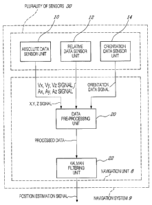
[0015] Fig. 1 is a block diagram which shows a visualization
system in accordance with a preferred embodiment of the
invention;
[0016] Fig. 2 is a graph which shows Kalman filter
compensation for position drift of the Doppler velocity
sensor unit 14;
[0017]Fig. 3 is a graph which shows impact, on position
estimate, of the acoustic position delay and Doppler
velocity sensor unit 14 failures;
[0018] Fig. 4 is a graph which shows position estimate
corrected for the acoustic position delay and Doppler
velocity sensor unit 14 failures;
[0019]Fig. 5 is a graph which shows calibration errors
effect on the position of the Doppler velocity sensor unit
14 system;
[0020] Fig. 6 is a graph which shows experimental results of
the impact of Doppler velocity sensor unit 14 failures on
the position estimates;
[0021] Fig. 7 is a graph which shows experimental results of
the Z position estimate during Doppler velocity sensor unit
14 failures; and
[0022] Fig. 8 is a block diagram which shows an embodiment
where a navigation system is advantageously used.
[0023] It will be noted that throughout the appended
drawings, like features are identified by like reference
numerals.
CA 02539591 2006-03-20
WO 2005/029001 PCT/CA2004/001734
- 6 -
DETAILED DESCRIPTION OF THE PREFERRED EMBODIMENT
[0024] Now referring to Fig. 1, there is shown a block
diagram which shows a navigation system 9 in accordance
with a preferred embodiment of the invention.
[0025]A navigation system comprises a data pre-processing
unit 20 and a Kalman filtering unit 22.
[0026] It will be appreciated that in the case where a
failure/malfunction of a given sensor is detected, the data
provided by the given sensor is discarded.
[0027]The data pre-processing unit 20 receives a X, Y, Z
signal originating from an absolute data sensor unit 10, a
velocity signal (Vx, Vy, Vz) and an acceleration signal Ax,
Ay and Az provided by a relative data sensor unit 12 and an
orientation data signal provided by an orientation data
sensor unit 14.
[0028] The absolute data sensor unit 10 provides an absolute
position data signal at a first sampling frequency with. a
mean position error equal to zero. It will be appreciated
that in one embodiment of the invention, the absolute data
sensor unit 10 may be referred to as a position sensor
unit.
[0029] The relative data sensor unit 12 provides a relative
data signal at a second sampling frequency. It will be
appreciated that in one embodiment of the invention, the
relative data sensor unit 12 may be referred to as a
instantaneous velocity sensor unit. In fact,. such relative
data sensor unit 12 provides an instantaneous velocity,
resulting in a position estimate with a mean error which is
not equal to zero.
CA 02539591 2006-03-20
WO 2005/029001 PCT/CA2004/001734
[0030] It will be appreciated that the second sampling
frequency is substantially higher than the first sampling
frequency.
[0031] It will be appreciated that the absolute data sensor
unit 10 comprises at least one of a bathymeter providing a
2 signal and an acous tic sensor providing an X and Y
signal.
[0032] It will further be appreciated that the relative data
sensor unit 12 comprise s at least one of a Doppler sensor
providing a Vx, Vy and Vz signal and an accelerometer
providing an Ax, Ay and Az signal.
[0033] It will further ba appreciated that the orientation
data sensor unit 14 comprises at least one of gyroscope
sensors providing SZX , S2Y and S2Z signal, an inclinometer
providing SZX and SZY signal and a compass providing a S2~
signal.
[0034] The data pre-processing unit 20 pre-processes the
received data and provides processed data to the Kalman
filtering unit 22.
[0035] As explained below, the Kalman filtering unit 22
provides a position estimation signal.
[0036] In the preferred embodiment of the invention, the
remotely operated vehicle navigation system comprises a
plurality of sensors 30, providing information on the
vehicle's position and movement, and a navigation unit 8.
Preferably, sensor data provided by the plurality of
sensors 30 is redundant in order to improve position
estimates and overcome sensor failures.
CA 02539591 2006-03-20
WO 2005/029001 PCT/CA2004/001734
_ g _
(0037] As disclosed below, the navigation unit 8 uses sensor
data provided by the plurality of sensors 30 and evaluates
. the best possible estimate of the position of the vehicle.
As disclosed below, the navigation unit 8 operates using
Kalman filtering techniques in the preferred embodiment.
[0038]More precisely, the navigation unit 8 merges the
position signal provided by the absolute data sensor unit
and the velocity signal provided by the relative data
sensor unit 12 using an orientation signal provided by the
10 orientation data sensor unit 14 in order to provide a real-
time position estimation signal.
[0039] In the preferred embodiment, the absolute data sensor
unit 10 comprises a bathymeter sensor unit providing a Z
signal and an acoustic sensor unit providing an X and Y
signal.
(0040] Still in the preferred embodiment of the invention,
the relative data sensor unit 12 comprises a Doppler sensor
unit providing a Vx, Vy, Vz signal and an accelerometer
sensor unit providing an Ax, Ay, Az signal.
[0041] The orientation data sensor unit 14 comprises, .in the
preferred embodiment of the invention, a gyroscope sensor
unit providing an S2X , SAY and S2~ signal, an inclinometer
providing an SZX and S2Y signal and a compass providing a
S2Z signal. It will be appreciated that redundancy is
advantageously used~in order to avoid sensor failures.
[0042] Prior art work related on navigation systems. which
uses Doppler sensors and acoustic sensors may be found in
Whitcomb, L. L., Yoerger, D. R., Hanumant, S. "Combined
Doppler/LBL Based Navigation of Underwater Vehicles," Proc.
of the 11th Lnternational Symposium on Unmanned Untethered
CA 02539591 2006-03-20
WO 2005/029001 PCT/CA2004/001734
- 9 -
Submersible Technology, Durham, NH, August 1999 and in
Spindel, R. C., Porer, R.P., Marquet, W. M., Durham, J. L.
"A high-resolution pulse-Doppler underwater acoustic
navigation system." IEEE Journal of Oceanic Engineering,
vol.OE-l, no. l, pp. 6-13, 1976).
[0043]Someone skilled in the art will appreciate that in
real systems, sensors do not always send data at a fixed
rate and data acquisition is often intermittent. So
additional developments take place to deal with
asynchronous data delivery and delays in measurements. A
delay in a measurement is preferably defined as the time
between a moment~where a measurement is valid and a moment
where it is available to the navigation unit-.
[0044]It will be appreciated that the navigation unit is
preferably adapted to accept various rates of data
originating from the plurality of sensors.30. Furthermore a
filter switching process is used to ensure that only valid
data is used for the position estimate.
[0045]It will be appreciated that the gyroscope and
accelerometer sensor unit, usually provides position,
linear velocities and accelerations, orientation, and
angular velocities. However, in the preferred embodiment of
the invention, only orientation, angular velocities, and
accelerations are provided by the gyroscope and
accelerometer sensor unit.
[0046] As disclosed previously, the plurality of sensors
of the navigation system 9 comprise the acoustic sensor
unit which provides the X, Y, 2 signal of a sonar
transducer mounted on the submarine.
CA 02539591 2006-03-20
WO 2005/029001 PCT/CA2004/001734
- 10 -
[0047]It will be appreciated that the position signal
provided by the acoustic position sensor unit and the Z
signal provided by the bathymeter sensor unit are combined
together to provide the absolute position signal. It will
be appreciated that, in the preferred embodiment of the
invention, the' Z signal is collected from the bathymeter
sensor unit rather than from the acoustic position sensor
unit as the bathymeter sensor unit provides a much more
accurate, faster and reliable measure.
[0048]As explained above, the relative data sensor unit 12
'of the plurality of sensors 30 of the navigation system 9
further comprise a Doppler velocity sensor unit, commonly
identified as DuL, and which provides a X, Y, Z linear
velocity signal of the vehicle. Upon integration of the
linear velocity signal of the vehicle, position X, Y, and 2
is provided.
[0049] In the preferred embodiment, the plurality of sensors
30 have the following characteristics:
Instrument Variable Sampling PrecisionRange Variance
frequency
DVL Vas, Vy, 6 Hz +0.2% 0.5-30 0.00009
m
(RDI 1200) Vz 1 mm/s
Acoustic
positioning X, Y 0.25 Hz +0.2 m 120 cone 0.005
system Position +_ 0.5% over
of
(Linquest distance 1500 m
TrackLink 1500HA)
Bathymeter Z 5 Hz +1 cm 0-270m 0.000013
(ParoscientificPosition
8CDP270-I)
(0050]Kalman filters are well covered in Brown, R.G., Hwang,
P.Y.C. Introduction to Random Signals and Applied Kalman
Filtering, 3rd edition, John Wiley & Sons, 1997. As known
by someone skilled in the art, a Kalman filter uses an
CA 02539591 2006-03-20
WO 2005/029001 PCT/CA2004/001734
- 11 -
optimal linear estimator based on an iterative and
recurssve process.
[0051] More precisely, the Kalman filter recursively
evaluates an optimal estimate of the state of a system_
Typically, a vector describing the state of a vehicle
evolving in a 3D space may be expressed as
[0052] x=~x y ~ x y z a a y nx ~y ~~
[0053] where x y Z are position coordinates of the vehicle,
are corresponding velocities, arty are Euler angles
describing the orientation of the vehicle and ~zx ~y ~Z are
the angular velocities.
[0054] In the preferred embodiment, the Kalman filter used,
in the Kalman filtering unit 22, applies only to the
position of the vehicle. X vector is defined as
X=~x y z x y z' .
[0055] The Kalman filter produces a new estimate of the
position of the vehicle when one of the following
situations occurs. If a new position signal originating
from the acoustic position sensor unit is available, then
the Kalman filter of the Kalman filtering unit 22 computes
the new estimate with the new position signal (measurement
update process). If there is no new position signal
available before a fixed amount of time dt, then the Kalman
filter updates a current position based on previous
information of position and velocity (time update process).
[0056] As described by following equations 1 and 2, the
optimal estimate from the previous iteration, noted X(k-1)
is projected in time through state transition matrix A, and
the noisy inputs U(k) (relative data sensor unit) are fed
CA 02539591 2006-03-20
WO 2005/029001 PCT/CA2004/001734
- 12 -
to the system through matrix B, relating the inputs to the
state.
(0057] Ppriori = A' P' Ai+Q ( 1 )
[005$] X(k)=A~X(k-1)+B-U(k) (2)
[0059] In equation 2, the state ~. is the linear position of
the vehicle and U is the input from a linear velocity
sensor. Matrices A and B reflect the kinematics of the
system.
[0060] Equation 1 proj ects in time the error covariance
matrix P, representing the variance of the error on the
estimate state X. Q is the covariance matrix associated
with the process noise from the measurements U(k).
[0061] This process is formalized by Equations 3 to 5, in
which direct noisy state measurements Z (k) coming from the
absolute sensor unit 10 are compared with the prior state
estimate ~(kpaSt), yielding a correction to apply to this
prior estimate to obtain the new estimate X(k). Matrix H
relates the measurements to the state.
[0062] K = Ppriori ' H ~' (H' Ppriori ' H''~ R) 1
[0063] X~orrige(kpast)='Y(lcpast)+K'(Z-H~X(kpast)) ('4)
[0064] P= (1-K ~ H) ~ Pp~.iori ( 5 )
[0065] The importance of each estimation (the prior estimate
X(kpasr) and the measurement Z (k) ) is determined by the
Kalman gain K.
[0066] The Kalman gain K is in turn determined by matrices Q
and R, which respectively represent the process noise
CA 02539591 2006-03-20
WO 2005/029001 PCT/CA2004/001734
- 13 -
covariance (indirect measurements) and the measurement
noise covariance (direct measurements). The Kalman gain K
takes a value between 0 and l, 0 representing the use of
the indirect measurements only, 1 representing the direct
measurements only.
[0067]The error covariance matrix P, modified in equation 1,
is again corrected in equation 5 in order to reflect the
measurement update process. Continuing with the previous
example, Z(k) in equation 4 represents a measurement coming
from a position sensor and H is equal to [1 0] since there
is direct correspondence between Z and X.
[0068]The noise originating from the Doppler velocity sensor
unit is accumulated over every iteration because the
velocity is integrated to obtain the position. This results
in a diverging position error and therefore the acoustic
position sensor unit alone becomes unusable over long
periods of time as shown .in Fig. 2. The position error of a
typical direct position sensor, such as the acoustic
position sensor unit is important. These systems are
subject to intermittence and have larger noise levels over
short periods of time. However, their position estimates do
not drift over time. The error is close to zero-mean, which
makes them more reliable on the long run.
[0069]The position estimation signal obtained from the
Kalman filtering unit 22 combining both the acoustic
position sensor unit and the Doppler velocity sensor unit
have been simulated. The results of the simulation are
shown in Fig. 2.
[0070]As shown in Fig. 2, the combination takes .advantages
from both the acoustic position sensor unit and the Doppler
velocity sensor unit and more precisely of the absence of
CA 02539591 2006-03-20
WO 2005/029001 PCT/CA2004/001734
- 14 -
drift from the acoustic position sensor unit and the
smoothness of the velocity signal provided by the Doppler
velocity sensor unit.
[0071] However, it will be appreciated that the basic Kalman
filtering unit 22, which was used for generating the
results of the simulation in Fig. 2, does not satisfy the
precision required by the application. First, the position
signal provided by the acoustic position sensor unit is not
valid at the time it becomes available, but at a certain
amount of time before. Second, if a sensor fault occurs, it
must be detected and the Kalman filtering unit 22 should
not incorporate data provided by the faulty sensor in a new
estimate. Finally, the update rate of the plurality of
sensors may vary with each sensor. For example, if the
vehicle is far from the transponder beacons, the measure
will take more time as an acoustic signal is dependent from
a distance to the transponder beacons.
[0072) It will be appreciated that in the preferred
embodiment of. the invention, data originating from each
sensor preferably require some transformations before being
sent to the Kalman filtering unit 22.
(0073]More precisely, the kinematics model of the vehicle
describes its movement relative to an inertial frame called
fixed frame. For convenience, the dynamic equations of the
vehicle are developed relative to its center of mass. A
reference frame identified as local is attached to the
center of mass and its orientation corresponds to the
principal axis of inertia. Therefore, the position signal
and the velocity signal obtained from the plurality of
sensors 30 is preferably transformed in order to describe
CA 02539591 2006-03-20
WO 2005/029001 PCT/CA2004/001734
- 15 -
the position and velocity of the local frame relative to
the fixed frame expressed in the fixed frame.
[0074]In the preferred embodiment, such processing is
performed by the data pre-processing unit 20.
[0075]The position signal provided by the acoustic position
sensor unit is processed as follows.
[0076] [FI~pLOCAC LYE - ~FI~pPINGER ~IXE ~Ot{FI~I'ELOCAL}~L°~LpPIrrGEx
~OC~L
[0077] where LFI~PLOC,u~» is the position vector of the center
of mass of the vehicle with respect to the fixed frame,
lF'~PPINGER~.~. is the position vector of the transponder (the
emitter portion of the acoustical system, and thus the
point whose position is measured by the acoustical system)
of the vehicle with respect to the fixed frame, where
Yot{FL~'ELOCAL~ is a rotation matrix for moving from a local
frame to the fixed frame in the past. The matrix. is built
using the orientation provided by the DQI ( r~ot~FI~I~',DQl~ )
and its orientation on the vehicle ( got f LOCAL,DQI} ) .
[0078] ~LOCALpP~GER~OCAL ~-S the position vector of the
transponder with. respect to the center of mass of the
vehicle and it is measured in the frame of the vehicle.
[0079]The velocity signal provided by the Doppler velocity
sensor unit is processed as follows.
[F~VLOC] =ROT{FIXE,DVL}CFLxEVDVL]
FIXE DVL
[0080] ; Where ROT{FrxE DvL} is the
-~FLYE~LOC] A ROT{FLYE,LOC}LLOCPDVL,LOC
FIXE
rotation matrix describing the orientation of the Doppler
velocity sensor unit relative to the fixed frame.
CA 02539591 2006-03-20
WO 2005/029001 PCT/CA2004/001734
- 16 -
[0081] [F~VDyL] is obtained using the Doppler velocity
DPL
sensor unit.
[0082] ~F~ES2LOC, is the angular velocity of the local frame
FIXE
obtained from the gyroscope sensor unit.
[0083] LLOCpDVL] is the position vector of the Doppler
LOC
velocity sensor unit relative to the local frame expressed
in the local frame.
[0084] As explained previously, sensors data are provided by
the plurality of sensors 30 at different and changing
rates.
[0085] It' will be appreciated that the sensor fusion
algorithm accepts asynchronous signals by switching .to the
appropriate estimation procedure depending on which signal
is provided. For instance, the Doppler velocity sensor unit
15~ provides the velocity signal at a rate approximately 12
times higher than the rate at which the position signal is
provided by the acoustic position sensor unit.
[0086]When the Doppler velocity sensor unit and the acoustic
position sensor unit provider new data, the Kalman filter
unit 22 is used. However, 11 times out of 12 only the
Doppler velocity sensor unit provides the velocity signal,
and so a simple integration of the velocity signal is used
in order to perform the position update, such integration
is performed in the Kalman filtering unit 22.
[0087] A time stamp is recorded when a position signal is
provided by the acoustic position sensor unit. The value of
the time stamp is the actual time less a calibrated delay.
This time stamp is associated with the position signal.
CA 02539591 2006-03-20
WO 2005/029001 PCT/CA2004/001734
- 17 -
[0088] The position estimate between two position signals is
kept in memory. T~lhen a new posit3.on signal is provided by
the acoustic position sensor unit, the algorithm performs a
correction on the position estima to recorded in the memory
at the time indicated by the time stamp associated with
this new data. Then position updates are performed from
this time to the actual time using the velocity signal
provided by the Doppler velocity sensor unit. In other
words, the position update ~Y(kP~St) of Equation 4 is replaced
by the new position estimate and then the position is
updated by integrating the velocity signal from this new
position estimate in the past t o the actual time using
Equation 2. This integration pha se continues until a new
position signal provided by thel acoustic position sensor
unit becomes available. In the preferred embodiment, such
processing is performed by the Kalman filtering unit 22.
(0089]The data are generated with the dynamic model of the
vehicle and its corresponding controller. On Fig. 2 and
further, the real position of th_e model is identified as
Virtual submarine signal. A wh z te~ noise with variance
obtained from experimentations, as shown above, is added to
the Virtual submarine signal posit ions in order to generate
the position signal provided by the acoustic position
sensor unit.
[0090] The velocity signal provided by the simulated Doppler
velocity sensor unit is obtained from the velocity of the
model. The position signal provided ~by the acoustic
position sensor unit is identified as "V Positioning
signal" and the Doppler velocity sensor unit is identified
as "DVL only position signal" while the position estimate
provided by the Kalman filtering unit is identified as
"Kalman position signal".
CA 02539591 2006-03-20
WO 2005/029001 PCT/CA2004/001734
- 1s -
(0091] The results of the first simulation, shown in Fig. 2,
shows the Kalman position signal provided by the Kalman
filtering unit 22, of the position signals provided using
the acoustic position sensor unit and the velocity signal
provided by the data Doppler velocity sensor unit.
[0092] The vehicle starts at position zero, then reaches the
first target at -2 m. At time t - 500 seconds, the vehicle
reaches the position target 0 m and returns to the -2 m
target at time t - 1000 seconds. The purpose of the
simulation is to validate the adequate execution of the
Kalman filtering unit 22. The position signal provided by
the acoustic position sensor unit are not shown in this
graph for clarity. The position drift for the Doppler
velocity sensor unit, and shown by the "DVL only position
signal", is very slow and the error becomes significant
only after one hour of simulation. The data plotted on this
graph represents 30 minutes of simulation starting after
four hours of simulation.
[0093]Tt will be appreciated that in this simulation, the
position signal provided by the acoustic position sensor
unit is generated instantaneously (i.e. without delay),
there are.no calibration errors on any systems and no
sensor failures in this simulation.
[0094] Now referring to Fig. 3, there is shown a graph which
shows a simulation intended to disclose the impact of
delays in the acoustic position sensor unit and failures in
the Doppler velocity sensor unit.
[0095] A delay of 5 seconds is set for the acoustic position
sensor unit. Also, in order to amplify the impact of the
position signal provided by the acoustic position sensor
unit on the position estimate, the variance related,to the
CA 02539591 2006-03-20
WO 2005/029001 PCT/CA2004/001734
- 19 -
acoustic position sensor unit is set to 0.002. During the
first 10 seconds, the effect of the. delay is that the
Kalman position signal curve is behind the Virtual
submarine signal curve.
[0096] Failure of the Doppler velocity sensor unit 14 occurs
at 11 seconds where the Kalman DVL active signal curve
changes from level one to level zero and become active
again at 12 seconds. During the failure time, the Kalman
filtering unit 22 con"ciders the Doppler velocity sensor
unit input as zero value. Delays in the acoustic position
sensor unit and failures in the Doppler velocity sensor
unit are inherent to this navigation system.
[0097] At 20 seconds after the beginning of the simulation,
the accumulated error of the delay in the acoustic position
sensor unit and the failure of the Doppler velocity sensor
unit is approximately 20 cm.
[0098] Now referring to Fig. 4, there is shown a further
simulation which discloses corrections made for the delay
in the acoustic position sensor unit and for the failure of
the Doppler velocity sensor unit. The description of the
correction applied for the delay in the acoustic position
sensor unit has been disclosed previously. The correction
applied in the case of the failure of the Doppler velocity
sensor unit is very simple in this algorithm and it works
fine for small period of time. The algorithm keeps the last
valid velocity signal and performs the time update
procedure with it. Then the valid velocity is reduced for a
certain percentage and the result becomes the new valid
velocity for the next time update.
CA 02539591 2006-03-20
WO 2005/029001 PCT/CA2004/001734
- 20 -
(0099]For a longer period of time, the algorithm stops to
perform the time update procedure and the controller
changes from automatic to manual mode.
(0100]During the first 10 seconds of the simulation, the
position estimate curve (i.e. "Kalman position signal"
curve) follows the position curve (i.e. "Virtual submarine
signal" curve) of the mode 1. This represents an improvement
compared to the previous simulation. The first Doppler
velocity sensor unit failure occurs at 11 seconds as shown
by the "Kalman DVL active signal" curve. While there is
still a deviation of the position estimate relative to the
position of the vehicle, the position error generated by
the failure of the Dopple r velocity sensor unit is small
compared to the one obtained in the previous simulation. At
20 seconds after the beginning of the simulation, the
accumulated error of the delay and Doppler velocity sensor
unit failure is less than 5 cm. On the other hand, for a
failure of the Doppler velocity sensor unit lasting for
more than 5 seconds, as the one starting at 25 seconds, the
use of the last valid velocity generates an important error
because the vehicle change s its velocity direction during
the failure of the Dopple r velocity sensor unit. However,
as time passes, the poss.tion estimate curve is coming
closer by small steps to the vehicle position curve under
the influence of the acoustic position sensor unit while
the vehicle is at rest.
[0101]The velocity signal provided by the Doppler velocity
sensor unit system is the linear velocity of one particular
point on the vehicle. The transformation applied to the
velocities depends on the angular velocities and the
position coordinates of the centre of the Doppler velocity
sensor unit system relative to the local frame, This
CA 02539591 2006-03-20
WO 2005/029001 PCT/CA2004/001734
- 21 -
transformation is necessary and the calibration should be
done accurately. In the next simulation, shown in Fig. 5,
the Doppler velocity sensor unit is located at (-25 cm, 0,
25 cm) relative to the local frame. However, an error of 5
cm relative to the X and Z axis is made so this
transformation considers that the Doppler velocity sensor
unit system is located at (-20 cm, 0, -20 cm). The position
drift is dependent on the angular displacement and it can
be observed from Fig. 5 that a small error in the Doppler
velocity sensor unit position generates considerable error
on the position of the vehicle.
[0102]The Bathymeter sensor unit is used for providing the Z
coordinate and replaces the acoustic position sensor unit
used for the Z coordinate in simulation. However, the
interest is more on the observation of the behaviour
described previously than on reproduction of the simulation
results . In the following figures, the absolute sensor is
the bathymeter and the corresponding curve is identified as
"Bathymeter position signal". The Bathymeter sensor unit is
accurate and it can be considered as a reference to
establish a point of comparison with the curve obtained
from the Kalman filtering unit 22. The position curve
obtained by simple integration of the velocity signal
provided by the Doppler velocity sensor unit is not
plotted. However, the velocity signal provided by the
Doppler velocity sensor unit is the only data used in the
Kalman filtering unit 22 so the Kalman position signal
curve represents the position computed using the Doppler
velocity sensor unit. The "Kalman DVL active signal" curve
indicates whether the Doppler velocity sensor unit is
active (up level) or not (down level). In Fig. 6, the
Doppler velocity sensor unit system has failed many times.
For a short time failure, the use of the preceding velocity
CA 02539591 2006-03-20
WO 2005/029001 PCT/CA2004/001734
- 22 -
allows the Kalman filtering unit 22 to keep its curve on
the Bathymeter sensor unit curve. However, if the Doppler
velocity sensor unit is down for a longer period, the
Kalman filtering unit does not give acceptable results.
There is an example of that situation starting at 22
seconds in Fig. 6.
[0103]For the Z coordinate, since the Bathymeter sensor unit
has a fairly good accuracy and has a relatively high
bandwidth, the algorithm uses its signal during a Doppler
velocity sensor unit failure instead of performing the time
update using the preceding valid velocity as shown in Fig.
7.
[0104]A navigation system which uses a Kalman filtering unit
to merge data received from an acoustic position sensor
unit, a Bathymeter sensor unit and a Doppler velocity
sensor unit has been disclosed. Tha impact of the delay
from the position signal provided by the acoustic~position
sensor unit and the failure of the Doppler velocity sensor
unit on the position estimate have' been highlighted by
simulation results. The algorithm of: the Kalman filtering
unit 22 comprises a correction for a fixed time delay of
the acoustic position sensor unit and the simulation
results shows an appreciable improvement of the position
estimate.
[0105]However it is known by someone s killed in the art that
the time delay is not fixed. A model of this time delay may
therefore be created in order to get the complete benefits
of this development. During short failures of the Doppler
velocity sensor unit, the navigation algorithm compensates
for missing information. It will be appreciated that it is
of prime importance to measure accurately the position and
CA 02539591 2006-03-20
WO 2005/029001 PCT/CA2004/001734
' . - 23 -
orientation of the position systems on the vehicle in order
to perform the coordinate transformations relative to the
local frame precisely.
[0106] Now referring to Fig. 8, there is shown a block
diagram which shows how the navigation system 9 may be
advantageously used in a remotely operated submarine.
[0107]The system comprises the navigation system 9, a
virtual environment generation unit 40, a user interface
42, a processing unit 44, a memory unit 46 and a data
acquisition unit 48.
[0108]The virtual environment generation unit 40 generates a
virtual environment where the remotely operated submarine
operates as explained below.
[0109]The user interface 42 is used to display the generated
virtual environment to an operator. The user interface 42
may be also used in order to control the remotely operated
submarine.
[0110]The data acquisition unit 48 provides an acquired data
signal. The data acquisition unit 48 may be any one of a
camera, a sonar and a laser. The data acquisition unit 48
is used in order to provide~pertinent information collected
in the surrounding of the remotely operated vehicle.
[0111]The processing unit 44 receives the acquired data
signal, processes the received acquired data signal and
provides the processed data to the virtual environment
generation unit 40.
[0112]The memory unit 46 may be used in order to store at
least~one part of the processed, data.
CA 02539591 2006-03-20
WO 2005/029001 PCT/CA2004/001734
- 24 -
[0113] The virtual environment generat ion unit merges the
position estimation signal and the pro cessed data signal to
generate the virtual environment. Pref=erably the generated
virtual environment is a 3-dimension view of the remotely
operated vehicle together with surrounding objects of
interest. The objects of interest ara preferably detected
using the data acquisition unit 48_ Alternatively, the
objects of interest may also be inputt=ed, by the operator,
in the virtual environment generatred by the virtual
environment generation unit 40 using the user interface 42.
It will be appreciated that the virtual environment may
further comprise navigation data related to the remotely
operated vehicle. Such navigation data may comprise at
least one of orientation, speed, heading, etc.
(0114]It will be appreciated that in such embodiment the
remotely operated vehicle may be advantageously used, due
to its precise navigation sxstem 9 providing the position
estimation signal (position in real-time) in order to
locate defects, in order to follow up on detected defects,
in order to manipulate objects or in order to perform a 3D
rebuilding of an immersed structure or of the sea bed.
[0115]In the case where the remotely operated vehicle is
used to perform a 3D rebuilding of an smmersed structure or
of the sea bed, the data acquisition unit is a sonar.
(0116] In the case where an immersed structure is inspected,
the immersed structure may be any one of a dam, an intake
structure, a spillway, a stop log, a draft tube, a ship
hull, or a bridge pillar.
[0117] In the case of a dam or a bridge pillar, cracks,
defects, and rock-concrete interfaces may. be inspected.
CA 02539591 2006-03-20
WO 2005/029001 PCT/CA2004/001734
- 25 -
[0118] In the case of an intake structure, trash racks,
gates, penstocks may be inspected.
[0119] In the case of a spillway, gate, concrete, steel and
pier may be inspected.
[0120]Alternatively, it will be appreciated that
hydroelectric turbines may be inspected from water,
cavitations erosion damages and cracks may be also
inspected.
[0121]Alternatively, it will be appreciated that a ship hull
may be inspected to detec t at least one of a defect, a~
foreign object and a security threat.
[0122]An operation arm may b a also connected to the remotely
operated vehicle and underwater tasks such as grinding,
welding, cleaning, object grabbing may be performed. Stop
logs may be unblocked also and damages may be located.
[0123] The embodiments of the invention described above are
intended to be exemplary only. The scope of the invention
is therefore intended to ba limited solely by the scope of .
the appended claims.