Note: Descriptions are shown in the official language in which they were submitted.
CA 02549963 2006-06-15
WO 2005/062075 PCT/US2004/040978
1 METHODS FOR ACQUIRING AND PROCESSING SEISMIC DATA FROM
2 QUASI-SIMULTANEOUSLY ACTIVATED TRANSLATING ENERGY
3 SOURCES
4
TECHNICAL FIELD
6
7 The present invention relates generally to seismic exploration, and more
8 particularly, to acquiring and processing seismic data generated from
9 generally simultaneously activated seismic energy sources.
11 BACKGROUND OF THE INVENTION
12
13 In the hydrocarbon exploration industry, remote sensing of underground
14 geological formations using seismic waves provides information on the
location,
shape, and rock and fluid properties of potential hydrocarbon reservoirs. The
16 standard technique comprises the activation of a source of acoustic energy
17 which radiates seismic waves into the earth. These seismic waves reflect
from
18 and refract through subsurface geologic layers (acoustic illumination or
19 insonification). The recording of these seismic waves by many different
receivers (pressure or motion sensors) are ideally situated so as to optimize
the
21 ratio of information obtained to cost. This basic
22 sourcing/insonificationlrecording procedure is repeated many times at
slightly
23 different locations over a subsurface region of interest.
24
However, the resolution required of the seismic data for a detailed
interpretation
26 and adequate risk reduction can be suboptimal given the cost constraints
27 inherent in seismic acquisition. Methods have been taught using generally
28 simultaneously fired energy sources in an effort to obtain more information
for a
29 given cost.
31 Edington, U.S. Pat. No. 4,953,657 teaches a method of time delay source
32 coding. In this method "a series of shots is made at each shotpoint with a
33 determinable time delay between the activation of each source for each
shot".
-1-
CA 02549963 2006-06-15
WO 2005/062075 PCT/US2004/040978
1 The "series of shots" refers to occupying each shotpoint location for
several
2 consecutive shots. This methodology may be acceptable for seismic
3 acquisition on land where seismic sources can easily remain fixed at one
shot
4 location for an indefinite time. However, the method is not well suited for
marine recording in which a seismic receiver cable is being towed behind a
6 boat. A certain minimum velocity is necessary to preserve the approximately
7 linear trajectory of the cable.
8
9 De Kok et.al, U.S. Pat. No. 6,545,944, teaches a method for acquiring and
processing seismic data from several simultaneously activated sources. In
11 particular, the method requires that several independently controllable
"'source
12 elements" be activated in a fixed sequence, at successive neighboring
13 locations. This activation sequence unavoidably smears the energy from a
14 - single effective source across several neighboring shot locations,
necessitating
an interpolation step and the introduction of unwanted interpolation noise.
16 Further, the success of building an effective source by spatial sequencing
of
17 source sub-elements appears to depend sensitively on source timing
precision
18 and sea-state.
19
Beasley et al., U.S. Pat. No. 5,924,049 also teaches a method of acquiring and
21 processing seismic data using several separate sources. In the preferred
22 embodiment, it teaches that the sources can be activated sequentially with
a
23 constant inter-source time delay (up to 15 and 20 seconds). During the
24 processing stage, the method requires anywhere from 2% to 33% of data
overlap between panels of data from different sources. Further, it relies on
26 conflicting dips to discriminate energy coming from different source
directions,
27 which requires a specific spatial relationship among the sources and the
28 recording cable, and thus is not well suited to simultaneous signals
arriving
29 from approximately the same quadrant. In a subsidiary embodiment, the
several sources can be activated exactly concurrently, in which case the
31 sources are then arranged to emit signature-encoded wavefields. The
32 decoding and signal separation associated with this type of concurrent
33 signature encoding is usually unsatisfactory. Furthermore, the sources need
to
-2-
CA 02549963 2006-06-15
WO 2005/062075 PCT/US2004/040978
1 be activated at both the leading and trailing ends of the spaced-apart
receivers,
2 which is inflexible.
3
4 The present invention contrasts with the aforementioned inventions and
addresses their shortcomings by teaching a novel way of acquiring and
6 processing seismic data obtained from two or more quasi-simultaneously
7 activated sources.
8
9 SUMMARY OF THE INVENTION
11 This invention teaches a method for the acquisition of marine or land
seismic
12 data using quasi-simultaneously activated translating seismic sources whose
13 radiated seismic energy is superposed and recorded into a common set of
14 receivers. Also taught is the subsequent data processing required to
separate
these data into several independent records associated with each individual
16 source. Quasi-simultaneous acquisition and its associated processing as
17 described herein enable high quality seismic data to be acquired for
greater
18 operational efficiency, as compared to a conventional seismic survey.
19
A method for obtaining seismic data is taught. A constellation of seismic
21 energy sources is translated along a survey path. The seismic energy
22 sources include a reference energy source and at least one satellite energy
23 source. A number of configurations for the arrangement of the seismic
24 sources and the locations of seismic receivers are disclosed. The reference
energy source is activated and the at least one satellite energy source is
26 activated at a time delay relative to the activation of the reference
energy
27 source. This activation of sources occurs once each at spaced apart
28 activation locations along the survey path to generate a series of
superposed
29 wavefields which propagate through a subsurface and are reflected from and
refracted through material heterogeneities in the subsurface. The time delay
31 is varied between the spaced apart activation locations. Seismic data is
32 recorded including seismic traces generated by the series of superposed
33 wavefields utilizing spaced apart receivers.
-3-
CA 02549963 2006-06-15
WO 2005/062075 PCT/US2004/040978
1 The seismic data is then processed using the time delays to separate signals
2 generated from the respective energy sources. More specifically, the
3 processing of the seismic data further includes sorting into a common
4 geometry domain and replicating the seismic traces of data into multiple
datasets associated with each particular energy source. Each trace is time
6 adjusted in each replicated dataset in the common-geometry domain using
7 the time delays associated with each particular source. This results in
signals
8 generated from that particular energy source being generally coherent while
9 rendering signals from the other energy sources generally incoherent. The
coherent and incoherent signals are then filtered to attenuate incoherent
11 signals using a variety of filtering techniques.
12
13 It is an object of the present invention to provide a method for
acquisition of
14 seismic signals generated "quasi-simultaneously" from several moving
separated sources activated with a small time delay, and their subsequent
16 accurate separation during data processing into independent data sets
17 exclusively associated with each individual source. This can greatly
improve
18 operational efFiciency without compromising data resolution.
19
BRIEF DESCRIPTION OF THE DRAWINGS
21
22 The following drawings illustrate the characteristic acquisition and
processing
23 features of the invention, and are not intended as limitations of these
24 methods.
26 FIG. 1 is a plan view of the acquisition of seismic data using the
invention with
27 two quasi-simultaneous sources;
28
29 FIG. 2 is a profile view of the acquisition of seismic data corresponding
to FIG.
1;
31
32 FIG. 3 illustrates the activation time delays being composed of a constant
part
33 and a variable part;
-4-
CA 02549963 2006-06-15
WO 2005/062075 PCT/US2004/040978
1 FIG. 4 is a common-shot gather showing the coherent superposed signals
2 from the reference and satellite sources;
4 FIG. 5 is a common-midpoint gather showing the coherent signals from the
reference source and the incoherent noise from the satellite source;
6
7 FIG. 6 compares migrated results from both conventional (one-source)
8 acquisition and multiple quasi-simultaneously activated sources; and
9
FIG. 7 is a flowchart summarizing the acquisition, trace-sorting, and noise
11 attenuation segments of this invention.
12
13 DETAILED DESCRIPTION OF THE PREFERRED EMODIMENTS FOR THE
14 INVENTION
16 This invention teaches a method for the acquisition of seismic data using
quasi-
17 simultaneous sources, as well as the processing of the superposed signals
in
18 order to separate the energy due to each source from the energy due to
every
19 other source in the constellation. For the purposes of this invention, the
term
"constellation" shall mean the set of spaced apart seismic sources bearing any
21 relative spatial relationship among themselves, and able to move as a whole
22 from one location to another as part of a seismic survey.
23
24 Quasi-simultaneous acquisition and its associated processing as described
herein enable high quality seismic data to be acquired at a much greater
26 operational efficiency as compared to a conventional seismic survey. The
term
27 "quasi-simultaneous" shall mean that the activation-time differences among
the
28 several sources in a constellation are not zero (thus the prefix "quasi"),
but yet
29 small enough (typically less than several seconds) so as not to interfere
with
the previous or succeeding shots of the seismic survey, viz., less than the
31 recording (or "listening") time of a shot record (thus the term
"simultaneous":
32 operationally simultaneous). Acquisition, trace sorting and time
correction, and
33 noise attenuation filtering are described in turn.
-5-
CA 02549963 2006-06-15
WO 2005/062075 PCT/US2004/040978
1 ACQUISITION
2
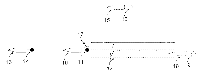
3 The first step is to acquire seismic data generated by quasi-simultaneous
4 sources. Referring to FIG. 1, in the most preferred embodiment, the
acquisition involves three-dimensional marine seismic surveying employing a
6 seismic vessel 10 towing a reference source 11 and several trailing
streamers
7 12 which contain seismic receivers, along with at least one other spaced
apart
8 satellite source 14, which is itself towed by a spaced apart vessel 13. The
term
9 "reference source" shall mean the source which is fired at seismic recording
time zero. It can be the source nearest the recording cable (if source and
cable
11 are being towed by the same vessel in marine recording), or for example it
can
12 be the source in the constellation which is activated first. In all cases,
the
13 satellite source time delays are with respect to the reference source. For
14 identification purposes, the constellation's location can be identified
with that of
the reference source. The term "satellite source" shall refer to any one of
the
16 energy sources other than the reference source. The term "time delay",
17 abbreviated "Td" shall mean a positive or negative time interval with
respect to
18 the reference source and recording time 0, and which is the sum of a
positive or
19 negative constant part (here abbreviated by "T~") and a positive or
negative
variable part (here abbreviated by "T~").
21 Thus Td=T~ + T". For the reference source, Td = 0.
22
23 Alternatively, vessel 13 and source 14 could be located (not shown)
collinearly
24 with and downstream from the streamer. These configurations in which the
reference and satellite sources are collinear with the set of receivers
provide
26 extra offsets as compared to a conventional single-source operation.
27 Preferably, the separation distance between the leading edge of the
streamers
28 12 and the upstream source 14 may be about the length of the streamers 12.
29 Likewise the separation distance between the trailing edge of the streamers
12
and the downstream source 14 (not shown) may be about the length of the
31 streamers 12.
-6-
CA 02549963 2006-06-15
WO 2005/062075 PCT/US2004/040978
1 Those skilled in the art will appreciate that the acquisition may also be
2 accomplished, by way of example and not limitation, with a source 19 towed
3 by a vessel 18 near the tail end of the receiver cable and between two of
the
4 several streamers 12, or with a source 16 towed by a vessel 15
perpendicularly displaced from the direction of the receiver cable, with a
6 source towed by a boat trailing the tail end of the receiver cable by a
fixed
7 amount, or even with a second independent source 17 towed behind vessel
8 10. The configuration in which the satellite source is perpendicularly
displaced
9 from the streamer of receivers provides extra azimuths as compared to a
single-source operation. Further, those skilled in the art will appreciate
that
11 cables of receivers can be towed behind more than one vessel, or that the
12 seismic receivers need not be towed behind a marine vessel but can be fixed
13 to the earth as in land recording, ocean-bottom recording, and marine
vertical-
14 cable recording, among others.
16 FIG. 2 is a profile view of the collinear acquisition geometry of FIG. 1.
The
17 reference source 11 (with indicated earth coordinates S~) is situated on
the
18 recording surface 20 (generally the surface of the Earth) and generates
19 seismic energy 22 which travels down to a geologic reflector 21 and is
reflected back toward the receiver cable 12 (one of whose receivers has the
21 indicated earth coordinates R). Meanwhile, the satellite source 14 (with
22 indicated earth coordinates S2) is activated quasi-simultaneously and it
also
23 generates seismic energy 23 which reflects back into the receiver cable,
24 where it superposes with the signal from the reference source 11 and where
both are recorded.
26
27 FIG. 4 shows a common-shot gather illustrating the superposition of energy
28 from two quasi-simultaneous sources. A receiver cable 43 records seismic
29 energy along a recording time axis 42. The reference source energy 40 and
satellite source energy 41 are interfering and superposed on each trace of the
31 common-shot gather.
-7-
CA 02549963 2006-06-15
WO 2005/062075 PCT/US2004/040978
1 Given a current location of the constellation within the seismic survey, its
Ns
2 sources are activated quasi-simultaneously. The term "Ns" shall refer to the
3 number of spaced apart sources populating the constellation. FIG. 3
illustrates
4 the quasi-simultaneous timing scheme for the case of Ns=4. The constellation
of sources is quasi-simultaneously activated at times 30 determined by the
6 interval of time required for the constellation to translate between
successive
7 shot locations, which is generally the translation distance divided by the
8 constellation velocity. Most preferably, a Global Positioning System is used
to
9 activate the reference activation source at predetermined intervals, for
example
25 meters. The quasi-simultaneous source activation-time delay Td 33 (with
11 respect to the reference source) is different for each source within the
12 constellation, and is a sum of two parts. The first component is a
13 predetermined positive or negative constant T~ 31 for a given source in the
14 constellation but can be different for different sources. Its optimum value
is
dictated by the operational need to capture all of the desired signal from
that
16 source into the seismic receivers during the current recording time window,
and
17 so depends on the specific acquisition geometry. It can be different for
each
18 source in the constellation, but is constant over the course (duration) of
the
19 survey (as tong as the constellation geometry does not change). In the case
of
a satellite source collinear with the seismic streamer as in FIG. 1, this time
21 might be, for example, several seconds in advance of (negative number) the
22 near-streamer reference source activation time.
23
24 The second component is a predetermined variable time delay T~ 32 which is
different for each source in the constellation, and also changes with each
26 succeeding location of the constellation within the seismic survey. In the
27 preferred embodiment this variable component is a predetermined positive or
28 negative random value whose value ranges from plus to minus ten times the
29 source waveform's dominant period, although greater times are also
possible.
This random time dithering introduces a source-specific time-delay encoding
31 (not signature encoding) among the several sources within the
constellation,
32 whose resultant wavefields are all superposed in the recording cable.
Although
33 not necessary, it may be beneficial to prevent successive random values of
Td
_g_
CA 02549963 2006-06-15
WO 2005/062075 PCT/US2004/040978
1 to be too close to one another. This can be avoided by requiring that
2 successive values of Td be differentiated by a predetermined minimum
positive
3 or negative value. This can be accomplished simply by generating a
4 replacement random value that is satisfactory. This overcomes the potential
problem of "runs" of the same value in a random sequence, which when applied
6 to the source time delays might create short patches of coherence where none
7 is desired.
8
9 Although T~ and T" are both predetermined, it is only their sum Td that is
required in processing, and due to possible slight variation in actual source
11 activation times, Td must be accurately measured and recorded during
12 acquisition.
13
14 The entire seismic survey then consists of quasi-simultaneously activating
the
entire constellation once at each geographic location in the survey (at
resultant
16 times 30), and then moving the constellation a predetermined amount to a
new
17 location, and repeating the quasi-simultaneous source activation procedure.
18
19 COMMON-GEOMETRY TRACE SORTING AND TRACE TIME-
CORRECTION
21
22 Trace sorting will now be described. After acquisition, each trace contains
23 superposed seismic signals (reflections, refractions, etc.) from each of
the Ns
24 sources. The first stage in separating the signals from the constellation's
several sources is to spatially reorganize the seismic traces from the common
26 shot gathers into a suitable domain in which the signal from each
successive
27 source in the constellation can be selectively made coherent and all others
28 made incoherent. As illustrated in FIG. 2, each trace includes a trace
header
29 24 which contains, among other information, earth coordinates of the
receiver
and the Ns sources, as well as the time delays Td for each of the Ns-1
satellite
31 sources. The common-shot gathers are resorted Ns times, once for each
32 source in the constellation. Each resorting follows the conventional
procedure
33 in which each given trace is placed into a particular common-geometry
gather
_g_
CA 02549963 2006-06-15
WO 2005/062075 PCT/US2004/040978
1 of traces, depending on the source and receiver coordinates and the type of
2 common-geometry desired. For example, common midpoint sorting dictates
3 that the algebraic average of the source and receiver coordinates be a
4 constant. Constant offset sorting dictates that the distance from source to
receiver be a constant. Because the trace header contains the coordinates
6 from Ns sources (two in the case of FIG. 2), the current trace is replicated
and
7 associated with Ns different midpoints or Ns different offsets, etc., one
8 associated with each of the Ns sources.
9
For each of the Ns sources with which the trace is in turn identified, the
time
11 delay associated with that trace and source (and which is recorded in
header
12 24) is applied in reverse to the trace timing. Thus, subtracting the time
delay
13 Td from the trace time allows the signals in the seismic trace from that
source
14 to align with similar signals on other traces within the particular
constant-
geometry gather, and coherent signals from that source are formed.
16
17 In the preferred embodiment the traces are resorted into Ns common-midpoint
18 domains, each common-midpoint domain associated with a particular source of
19 the constellation. As a visual aid, FIG. 5 shows a common-midpoint gather
from the same dataset as FIG. 4, and contains data ordered along an offset
21 axis 53 and a time axis 52.
22
23 Those skilled in the art will appreciate that other resorting may also be
24 realized, by way of example and not limitation, by resorting the traces
into
common-offset domains (useful for some kinds of prestack depth migration),
26 common-receiver domains (useful for recording and migration involving
27 acquisition via vertical marine cable, vertical seismic profile in a well,
or
28 ocean-bottom cable), common-azimuth domains (useful for illumination within
29 subsurface shadow zones), or indeed any other common-geometry domain in
which subsequent data processing will occur. In each case, resorting the
31 traces independently associates each common-geometry domain with a
32 particular one of the Ns sources in the constellation.
-10-
CA 02549963 2006-06-15
WO 2005/062075 PCT/US2004/040978
1 In this resorted and time-corrected domain, each source's signal in turn
2 becomes coherent and the signal from all other Ns-1 sources is made
3 incoherent and appears as random noise. In this way the signal from each one
4 of the Ns sources is made to "crystallize" into coherence at the expense of
the
other Ns-1 sources, producing Ns different datasets, one for each source of
the
6 constellation. This is illustrated in FIG. 5, in which the seismic signal 50
from
7 the reference source has been made coherent, while the seismic signal from
8 the satellite source has been turned into incoherent random noise which is
9 scattered throughout the common-midpoint gather.
11 NOISE-ATTENUATION FILTERING
12
13 The next step is filtering out the unwanted noise from each of the resorted
14 datasets. There are several approaches, depending on the particular common-
geometry domain and whether the data are migrated or not. In the preferred
16 embodiment, random noise suppression is applied to common-midpoint
17 gathers in which coherent signal events tend to assume a hyperbolic
trajectory
18 while random noise does not follow any particular trajectory. The coherent
19 signal events are localized in Radon space whereas the random noise is not
localized in Radon space. Muting out unwanted noise events in Radon space
21 followed by an inverse mapping to conventional time-offset space attenuates
22 the random noise. The remaining signal can be used directly, but also can
23 itself be time shifted back into decoherence, at which point it can be
subtracted
24 from the complementary gathers associated with the other sources prior to
their
Radon filtering.
2G
27 Those skilled in the art will appreciate that random noise attenuation may
also
28 be accomplished, by way of example and not limitation, by other techniques
29 such as stacking, F-X filtering, and also by Dynamic Noise Attenuation:
This
method is taught in a patent application entitled "Method for Signal-to-Noise
31 Ratio Enhancement of Seismic Data Using Frequency Dependent True
32 Relative Amplitude Noise Attenuation" to Herkenhoff et.al., USSN
10/442,392.
33 The DNA Method is an inverse noise weighting algorithm, which can often be
a
-11-
CA 02549963 2006-06-15
WO 2005/062075 PCT/US2004/040978
1 powerFul noise attenuation technique and can be used in conjunction with
other
2 techniques in any common-geometry domain. The disclosure of this patent
3 application is hereby incorporated by reference in its entirety. The
particular
4 importance of this specific step lies in its ability to largely preserve the
relative
amplitudes of the coherent signals in a gather in the presence of random
noise,
6 thus minimizing the effect of amplitude bias.
7
8 Because attenuation of random noise often amounts to a localized summing
9 over signal trajectories to achieve so-called "root-n" noise reduction,
different
signal domains require different summing trajectories. Further, because even
11 an approximate velocity model is useful to define signal trajectories as
part of
12 the migration summation process, random noise attenuation may be
13 accomplished by taking advantage of the signal/noise separation powers
14 inherent in seismic imaging. Given a velocity model, migration sums events
over a very large aperture (an areal aperture in the case of three-dimensional
16 migration), greatly attenuating random noise. In FIG. 6, the results of
migrating
17 with a known earth velocity are shown for both a conventional single-source
18 acquisition (left panel) and the two-source quasi-simultaneous acquisition
19 (some gathers from which are shown in FIGS. 4 and 5). Evidently for this
dataset migration summing has effectively attenuated the random noise
27 permeating the two-source input gathers from FIG. 5. More importantly, when
22 applied in the common-offset domain, migration produces noise-attenuated
23 common-offset volumes that preserve the prestack AVO information. It is
this
24 property that makes the common-offset embodiment particularly attractive.
Note that velocity analysis (needed for the migration), which measures
26 semblance, will work even on CMP gathers in which the random noise has not
27 been attenuated. Alternatively, migration of quasi-simultaneous source data
28 even with a suboptimal velocity function, followed by filtering, followed
by
29 demigration using the same velocity function can also attenuate random
noise.
All of the above techniques are equally preferred. Finally, one skilled in the
art
31 can appreciate that noise attenuation can also be realized by a
concatenation
32 of multiple processing steps such as those described above.
-12-
CA 02549963 2006-06-15
WO 2005/062075 PCT/US2004/040978
1 T he foregoing segments detailed by this invention are summarized in
flowchart
2 form in FIG. 7. At each successive location of the constellation within the
3 seismic survey, a master source timer 70 communicates the appropriate time
4 delay 71 (Td) to each of the Ns-1 satellite sources 72. (The reference
source,
by definition above, has a total time delay of zero.) The sources are thus
6 activated quasi-simultaneously, their energy enters and interacts with the
earth
7 layers 73, and the reflected and scattered waves, are recorded by a common
8 set of spaced apart receivers 74. The time delays Td associated with each
9 source are also recorded in 74.
11 After acquisition, each trace contains seismic events (reflections,
refractions,
12 etc.) from each of the Ns sources. The seismic data are resorted into Ns
13 common-geometry datasets 75 as explained in the reference to FIG. 2 above
14 (such as common-midpoint or common-offset, two particularly good and
preferred domains). Then the traces in each of the Ns-1 satellite source
16 datasets have applied to them the negative time delay 76 associated with
that
17 trace and that satellite source. Lastly, Ns noise-attenuation filtering
operations
18 77 can be applied, because in each of the Ns data volumes the energy from
19 only one source appears coherent, while the energy from all other sources
appears as incoherent noise.
21
22 V~Ihile in the foregoing specification this invention has been described in
23 relation to certain preferred embodiments thereof, and many details have
24 been set forth for purpose of illustration, it will be apparent to those
skilled in
the art that the invention is susceptible to alteration and that certain other
26 details described herein can vary considerably without departing from the
27 basic principles of the invention.
-13-