Note: Descriptions are shown in the official language in which they were submitted.
CA 02556896 2006-08-18
WO 2005/081191 PCT/GB2005/000631
ADAPTIVE 3D IMAGE MODELLING SYSTEM AND APPARATUS
AND METHOD THEREOF
Field of the Invention
This invention relates to an improved mechanism for
modelling 3D images. The invention is applicable to, but
not limited to, dynamic updating of a 3D computer model
in a substantially real-time manner using 2D images.
Background of the Invention
In the field of this invention, computer models may be
generated from survey data or data from captured images.
Captured image data can be categorised into either:
(i) A 2-dimensional (2D) image, which could be a
pictorial or a graphical representation of a scene; or
(ii) A 3-dimensional (3D) image, which may be a 3D
model or representation of a scene that includes a
third dimension.
The most common form of 2D image generation is a
picture that is taken by a camera. Camera units are actively
used in many environments. In some instances, where
pictures are required to be taken from a number of
locations, multiple camera units are used and the
pictures may be viewed remotely by an Operator.
For example, in the context of 2D images provided by,
say, a closed circuit television (CCTV) system, an
Operator may be responsible for capturing and
interpreting image data from multiple camera inputs. In'
this regard, the Operator may view a number of 2D
images,
SUBSTITUTE SHEET (RULE 26)
CA 02556896 2006-08-18
WO 2005/081191 PCT/GB2005/000631
2
and then control the focusing arrangement of a particular
camera to obtain a higher resolution of a particular
feature or aspect of the viewed 2D image. In this manner,
CCTV and surveillance cameras can provide a limited
monitoring of real-time scenarios or events in a 2D format.
The imageslpictures can be regularly updated and viewed
remotely, for example updating an image every few
seconds. Furthermore, it is known that such camera
systems and units may be configured to capture 360°
photographic images from a single location. Clearly, a
disadvantage associated with such camera images is the
lack of 'depth' on the 2,D image.
Notably, camera units and camera systems in general
operate from a fixed location. Thus, a further disadvantage
emanates from the ability of a user/Operator to only view a
feature of an image from the perspective
of a camera. Furthermore, camera units do not provide any
measurement data in their own right.
A yet further disadvantage associated with systems that
use CCTV and surveillance camera images is that the
systems do not contain the ability to provide 'data' (in the
normal sense of the word regarding, say binary data bits)
or to make measurements.
There are many instances when a user of image data
desires or needs a 'depth' indication associated with a
particular feature of an image, in being able to fully utilise
the image data. One of many examples where a 3rd
dimension of an image has proven critical is in the field
SUBSTITUTE SHEET (RULE 26)
CA 02556896 2006-08-18
WO 2005/081191 PCT/GB2005/000631
3
of surveying. There are many known techniques of
obtaining 3D data, for example using standard surveying
techniques, such as Theodolites, electronic digital
measurement techniques (EDM), etc. EDM, for example,
uses a very slow laser scan that locates the top of a
distal pole in 3D space in order to acquire 3D data. A
further 3D data capture technique is photagrammetry,
which allows a 3D representation to be created from two
or more known photographs.
Thus, 3D data capture techniques, such as 3D laser
systems, have been developed for, inter-alia, surveying
purposes to provide depth information to an image. It is
known that such 3D laser systems may incorporate a
scanning feature. This has enabled the evolution from a
user being able to obtain 50 3D data points per day from
EDM, to 1,000,000 3D points within say six minutes using
3D laser scanning.
The most common type of laser scanner system that is
currently used is an Infra-Red (IR) laser emitting
system. A laser is discharged from the scanning unit,
which reflects the IR signal back off the nearest solid
object in its path. The time in which the laser beam
takes to return to the scanner is calculated, which therefore
provides a measurement of the distance and position of the
point at which the laser beam was reflected, relative to the
scanner. The scanner emits a number of laser pulses,
approximately one million pulses every four minutes. The
point at which any beam is reflected, from a solid object, is
recorded in 3D space. Therefore a gradual 3D point cloud,
or point model is
SUBSTITUTE SHEET (RULE 26)
CA 02556896 2006-08-18
WO 2005/081191 PCT/GB2005/000631
4
generated as the laser scanner increases the area
coverage, each point having 3D coordinates.
3D laser scanning systems were originally developed for
the surveying of quarry sites and volume calculations for the
amount of material removed following excavation.
Subsequently, such 3D laser scanning systems have been
applied to other traditional surveying projects, including urban
street environments and internal building structures.
Referring now to FIG. 1, a known mechanism 100 for
generating 3D computer models from such captured 3D data is
illustrated. By performing a large number of surveys,
say using a 3D laser scanning approach 105, 3D image data
can be collated and used as a base to build subsequently
accurate 3D computer models of particular environments. The
3D computer models 110 can be built by virtue of the fact that
every point within the scan data has been
provided with 3D coordinates. Advantageously, once a model
has been developed, the model can be viewed from any
perspective within the 3D coordinate system.
However, the output 125 of such 3D computer models are
known to be only 'historically' accurate, i.e. the degree
of accuracy to which a model environment relates to the real
environment is dependent upon how much the real life
environment has changed since the last survey was carried out.
Furthermore, in order to update the computer model
130, further scans/3D surveys are required, which are
notoriously slow and expensive due to the time required to
obtain and process the 3D laser scan data.
SUBSTITUTE SHEET (RULE 26)
CA 02556896 2006-08-18
WO 2005/081191 PCT/GB2005/000631
Thus, there exists a need in the field of the present
invention to provide a 3D data capturing and modelling
system, associated apparatus, and method of generating a 3D
5 model, wherein the above mentioned disadvantages axe
alleviated.
Statement of Invention
In accordance with a first aspect of the present invention there
is provided an adaptive three-dimensional
(3D) image modelling system, as claimed in Claim 1.
In accordance with a second aspect of the present invention
there is provided a signal processing unit
capable of generating and updating a three dimensional (3D)
model from 3D data, as claimed in Claim 9
In accordance with a third aspect of the present invention there
is provided a method of updating a three
dimensional computer model, as claimed in Claim 10.
Thus, in summary, the aforementioned accuracy problems with
known 3D modelling techniques are resolved by using a 3D
computer model that is updated using views provided
by, say, a camera unit or camera system. The 2D images
provided by matching the perspective view of an image within
the model to that of an image of the environment. The 3D
computer model can therefore be updated remotely, using 2D
data.
Brief Description of the Drawings
SUBSTITUTE SHEET (RULE 26)
CA 02556896 2006-08-18
WO 2005/081191 PCT/GB2005/000631
6
FIG. 1 illustrates a known mechanism for generating 3D computer
models from captured 3D data.
Exemplary embodiments of the present invention will, now be
described, with reference to the accompanying drawings, in which:
FIG. 2 illustrates a mechanism for generating 3D computer models
from 2D data, in accordance with a preferred embodiment of the
invention;
FIG. 3 illustrates a preferred laser scanning operation associated
with the mechanism of FIG. 2, in accordance with a preferred
embodiment of the invention;
FIG. 4 illustrates a simple schematic of an image in the context of
a camera matching process; and
FIG. 5 shows a 3D representation of a road-scene image that can
be updated using the aforementioned inventive concept.
Description of Preferred Embodiments
In the context of the present invention, and the
indications of the advantages of the present invention over the
known art, the expression 'image', as used in the remaining
description, encompasses any 2D view
capturing a representation of a scene or event, in any format,
including still and moving video images.
The preferred embodiment of the present invention
proposes to use a 3D laser scanner, to capture 3D data
SUBSTITUTE SHEET (RULE 26)
CA 02556896 2006-08-18
WO 2005/081191 PCT/GB2005/000631
7
for a particular imagelscene. It is envisaged that 3D
laser scanning offers the fastest and most accurate
method of surveying large environments. Although the
preferred embodiment of the present invention is
described with reference to use with a 3D laser scanning
system, it is envisaged that the inventive concepts can be
equally applied with any mechanism where 3D data is
provided. However, a skilled artisan will appreciate that
there are significant benefits, in terms of both
speed and complexity, in using the inventive concept
with a 3D laser scanning system to be the initial 3D
computer model.
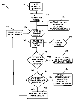
Referring now to FIG. 2, a functional block
diagram/flowchart of an adaptive 3D image creation
arrangement 200 is illustrated, configured to implement
the inventive concept of the preferred embodiment of the
present invention. The preferred embodiment of the
present invention proposes to use a 3D laser scanner
205, such as a Riegl '"' 2210 or a 2360, to obtain 3D co-
ordinate data. Such a 3D laser scanner 205 has a range of
approximately 350 metres and can record up to 6 million
points in one scan. It is able to scan up to 336° in the
horizontal direction and 80° in the vertical direction.
One option to implement the present invention is to use
Riegl's "RiScan" software or ISite Studio 2.3 software to
capture the 3D data.
It is envisaged that the inventive concept of the present
invention can be applied to one or more camera units
that may be fixed or moveable throughout a range of
horizontal and/or vertical directions.
SUBSTITUTE SHEET (RULE 26)
CA 02556896 2006-08-18
WO 2005/081191 PCT/GB2005/000631
g
Notably, every captured data point in the scan comprises
3D co-ordinate data. As well as 3D coordinates, some
laser scanners also have the ability to record RGB (red,
green, blue) colour values as well as reflectivity values
for every point in the scan. The RGB values are
calculated by mapping one or more digital photographs,
captured from the scanner head, onto the points. It is
necessary to have sufficient lighting in order to record
accurate RGB values; otherwise the points appear faded.
The reflectivity index is a measure of the reflectivity of
the surface of which a point has been recorded. For
example, a road traffic sign is highly reflective and
would therefore have a high reflectivity index. It would
appear very bright in a scan. A tarmac road has a low
reflectivity index and would appear darker in a scan.
Viewing a scan in reflectivity provides useful definition
of a scene and allows an Operator to understand the data
of an environment that may have been scanned in the
dark.
Thus, in this manner and in addition to the enormous
number of raw 3D data points that are extracted from the
3D laser scanning system, additional criteria can be used
to provide a more accurate 3D computer model from the
raw data.
The output from the 3D laser scanning system 205 is
therefore 3D co-ordinate data, which is input into a 3D
computer model generation function 210. There are a
number of ways that the 3D computer model generation
function 210 may build 3D models from scan data. In a
first method, surfaces can be created using algorithms
SUBSTITUTE SHEET (RULE 26)
CA 02556896 2006-08-18
WO 2005/081191 PCT/GB2005/000631
9
such as that provided by ISite Studio 2.3, whereby meshes
are formed from 3D co-ordinate data. The surfaces can be
manipulated, if required, using smoothing surfaces and
filtering algorithms written into ISite Studio. Such
filtering techniques are described in greater detail
1 ater.
The surfaces may then be exported, in 'dxf format, into
Rhinoceros 3D modelling software. A common method for
modelling road surfaces is to import the mesh created in
ISite Studio and create cross sections, say perpendicular to a
single dimension aspect of the image such as a length of
road. Cross section curves may then be smoothed and lofted
together to form a smoother road surface model. This
method allows the level of detail required on a road surface
to be accurately controlled by the degree of smoothing.
In a second method, CAD data drawn in ISite Studio 2.3
may be exported into Rhinoceros 3D. The lines are used
to create surfaces and three-dimensional objects.
In a third method, 3D co-ordinate data may be exported from
ISite Studio 2.3 directly into Rhinoceros 3D in
'dxf format. The 3D co-ordinate data may then be converted
into a single "point cloud" object, from which the 3D models
can be built. Rhinoceros 3D modelling software has many
surface modelling tools, all of which may be applicable,
depending on the object to be modelled.
In a fourth method, a combination of 3D co-ordinate data,
CAD lines and surfaces imported from ISite Studio 2.3 may
SUBSTITUTE SHEET (RULE 26)
CA 02556896 2006-08-18
WO 2005/081191 PCT/GB2005/000631
be used to model a scanned environment and built in the
Rhinoceros 3D software.
5 Once an initial model has been built, it may be exported
into 3D Studio Max (say, Release 6) where further
modelling and optimization may be applied. In
particular, 3D Studio Max is preferably used to produce
the correct lighting and apply the textures for the scene.
10 Textures are preferably created from digital
photographs taken of the pertinent environment. The
textures may be cropped and manipulated in any suitable
package, such as Adobe Photoshop.
It is envisaged that the models may be animated in 3D
Studio Max and then rendered to produce movie files and
still images. There are various rendering tools within the
software that can be used, which control the accuracy and
realism of the lighting. However, the rendering tools are
also constrained by the time taken to produce each
rendered frame. The movie files are then composited using
Combustion 2.1.1, whereby annotations and effects can be
added.
The 3D models can be exported out of 3D Studio Max for
real-time applications, allowing an operator to navigate
around the textured scene to any location required. Two
formats are currently used in this regard:
(i) The model can be exported in VRML format and
viewed in a VRML viewer, e.g. Cosmo Player. The
VRML format will also import any animation created in
3D Studio Max. Therefore, an operator is able to navigate
to any position within the pertinent scene whilst an
SUBSTITUTE SHEET (RULE 26)
CA 02556896 2006-08-18
WO 2005/081191 PCT/GB2005/000631
11
animated scenario is running in the background. The
VRML format may be hindered by the file size restriction
that forces the models and textures to be minimized and
optimized to allow fluid real-time navigation.
(ii) The model can be exported into Quadrispace software.
Notably, Quadrispace does not import animation
information. However, Quadrispace does operate with a
3D and 2D interface so that the Operator is able
to navigate around a scene in 3D space whilst a smaller
window, located in say, a lower corner of the scene,
shows the operator's position with the model on a 2D
plan. It will then update the view in the 3D window. Even
though it is possible to import reasonably large
files into Quadrispace, it is still necessary to optimize the
models in 3D Studio Max prior to exporting.
Thus, building 3D computer models from scan data can be
performed in a number of ways. The correct method is
very much dependent upon the type of model to be built
and should be selected by considering, not least:
(i) The complexity of the scanned object;
(ii) The required accuracy of the 3D model; and
(iii) Any memory limitations imposed on the final model
file size.
Thus, 3D modelling should only be performed by a
competent and experienced 3D modeller, who has prior
knowledge of modelling with scan data. For example, if a
3D real-time 3D model were to be created of a building,
the 3D computer modeller would be conscious of the fact
that the model would have to be of minimal size, in-order
for a real-time 'walk-through' simulation to run smoothly.
SUBSTITUTE SHEET (RULE 26)
CA 02556896 2006-08-18
WO 2005/081191 PCT/GB2005/000631
12
The 3D computer modelling operation 210 using the
imported 3D raw data is a relatively simple task, where
lines are generated to connect two or more points of raw
data. A suitable 3D modelling package is the Rhinoceros tm
3D modelling software. However, a skilled artisan will
appreciate that a 3D laser scanning system exports huge
amounts of raw data. Most of the complexity involved in
the process revolves more around the manipulation or
selective usage of scan data, rather than the simple
connection of data points within the 3D computer
modelling operation 210. The preferred implementation of
the 3D laser scanning operation is described in greater
detail with respect to FIG. 3.
Advantageously, once the 3D computer model has been
generated by the 3D computer modelling function
/operation 210, it is possible for any Operator or user of
the 3D model to view the dimensionally-accurate 3D
computer model from any perspective within the 3D
environment. Thus, an initial output 215 from the 3D
computer model 210 can be obtained and should be
(relatively) accurate at that point in time.
As indicated earlier, this model is only historically
accurate, i.e. the computer model is only accurate at the
time when the last laser scan was taken and until such time
that the 3D environment changes. Typically, it is not
practical to continuously scan the environment to
update the 3D computer model. This is primarily due to
the time and cost involved in making subsequent scans.
For example, a 3D laser scanner with corresponding
software would cost in the region of ~100k. Hence, it is
SUBSTITUTE SHEET (RULE 26)
CA 02556896 2006-08-18
WO 2005/081191 PCT/GB2005/000631
13
impractical, in most cases, to leave a 3D laser scanner
focused on a particular scene. Furthermore, as the
amount of data that is used to update the model is huge,
there is a commensurate cost and time implication in
processing the 3D data.
The preferred embodiment of the present invention,
therefore, proposes a mechanism to remove or negate the
historical accuracy of the 3D computer model by
regularly or continuously updating the model with
pertinent information. In particular, it is proposed that a
3D computer model may be updated using 2D
representations, for example obtained from one or more
camera units 225 located at and/or focused on the 'real'
scene of the model. Thus, a modelled scene may be
continuously (or intermittently) updated using camera
(2D image) matching techniques to result in a
topographically and dimensionally accurate view
(model) of a scene, i.e. updating the model of the scene
whilst it is changing.
In this context, it is assumed that the 2D images
generated by a camera unit may be obtained wirelessly,
and by any means, say via a satellite picture of a scene.
Furthermore, the camera units preferably comprise a
video capture facility with a lens, whereby an image can
be obtained via pan, tilt and/or zoom functions to allow
an Operator to move around the viewed image.
Preferably, the one or more camera units 225 of a
camera system is/are configured with up to 360° image
capture, to obtain sufficient information to update the 3D
computer models remotely. The updating of the 3D
computer model is preferably performed by importing
one
SUBSTITUTE SHEET (RULE 26)
CA 02556896 2006-08-18
WO 2005/081191 PCT/GB2005/000631
14
or more images captured by the camera system into the
background of the model.
In order to determine changes to a 3D computer model
based on a 2D image from a camera, the preferred
embodiment of the present invention proposes to use a
'virtual' camera in 3D space. The virtual camera is
positioned in 3D space to replicate the 'real' camera that
has taken the 2D image. The process of identifying
the location of the 'virtual' camera and accurately
comparing a match of the 2D image with a corresponding
view in 3D space is termed 'camera matching' 220. The
process of camera matching, i.e. matching of the
perspective of the photographic image to the image seen
by a virtual camera, to a model in 3D space can be better
appreciated with reference to FIG. 4.
It is envisaged that the camera match process may
compare a number of variables, comprising, but not
limited to, projection techniques for projecting 2D images,
a resolution of the projected 2D image, a distance of a
pertinent object from the camera taking the 2D image, a
size or dimension of the object and/or a position of the
object within the image as a whole. A suitable camera
unit to implement the aforementioned inventive concept is
the iPIX t'" 82000 camera, which captures two images with
185 degree fields of view.
Referring now to FIG. 4, a perspective view 400 of a
picture of a table is illustrated, together with a
computer model 470 of the same table.
SUBSTITUTE SHEET (RULE 26)
CA 02556896 2006-08-18
WO 2005/081191 PCT/GB2005/000631
An accurate 3D computer model of a pertinent object or
environment may be opened using the 3D modelling
software package: 3D studio Max ~" by Discreet 'm. Here,
5 the photographic image is opened in the background of a
view-port, within which the 3D model is visible. A camera
match function (say camera match function 220 of FIG. 2)
which is offered as a feature of this software, is then
selected and the Operator is prompted to select key points
10 on the 3D computer model that can be cross
referenced to the photographic image. For example the
four corners of the table 410, 420, 430 and 440 may be
selected, together with, say, two of the table leg bases 450
and 460.
Once the key points are saved, the Operator must select
each point individually and click on the corresponding
pixel of the photograph. Finally, once all the points on the
model have been cross-referenced to the photograph, the
software creates a 'virtual camera' 405 in the 3D
space model environment, which can then be positioned to
display in the same perspective the same image in 3D
space as the 2D photographic image viewed from the 'real'
camera. Thus, the Operator is able to match the 3D
computer model points 415, 425, 435, 445, 455 and 465
with the corresponding points 410, 420, 430, 440, 450 and
460 from the photographic image. Thereafter, the Operator
is able to identify any change to the scene, and replicate
this in the 3D model.
Additionally, it is envisaged that the photographic image
may be continuously replaced with one or more updated
photographs, preferably captured from the same camera
and perspective. If something within the scene has
changed,
SUBSTITUTE SHEET (RULE 26)
CA 02556896 2006-08-18
WO 2005/081191 PCT/GB2005/000631
16
it is possible to use known dimensional data of other
parts of the scene to update the computer model. The
photographic images) may be updated manually, upon
request by an Operator, or automatically if a change in
the environment is detected.
In the above context, the term 'virtual' camera is used to
describe a defined view in the computer modelling
software, which is shown as a camera object within the 3D
model.
Referring back to FIG. 2, and notably in accordance with
the preferred embodiment of the present invention, it is
proposed that the 3D computer model 210 is compared
with substantially real-time data (or at least data recently)
obtained using a camera system 225. The camera system
225 captures 2D images, which are then used to ascertain
whether there has been any change to the viewed (and 3D
computer modelled) environment. In this regard, in order
to ascertain whether the 3D model is accurate, a
comparison is made by the computer or the Operator
between the visual data contained in the image captured by
the camera units) in step 225 and that contained in the 3D
computer model 210. The associated 3D computer
model 210 may then be modified with any updated 2D
information, to provide an updated 3D computer model
230.
Thus, it is proposed that a 'virtual camera' is created in 3D
space that allows the Operator to view the 3D model
from the same perspective as the captured image(s), i.e. on
a similar bearing and at a similar range to the camera unit
that initially captured the image. In this manner, the
provision of a 'virtual camera' in 3D-space within
SUBSTITUTE SHEET (RULE 26)
CA 02556896 2006-08-18
WO 2005/081191 PCT/GB2005/000631
17
the model allows the 3D modeller to add or modify any
aspect of the 3D model in order to match the photographic
image(s).
For some applications of the inventive concept herein
described, such as re-creation of traffic incidents, it is
envisaged that a video or movie file may be generated using
automatic vehicle identification (AVI) means 235.
Preferably, a High-tech system with real-time streaming of
2D data images is implemented. Thus, in this manner, the
High-tech system is envisaged as being able to automatically
update the computer model with continuous streaming of
digital images, in step 240. Furthermore, it is envisaged that
an update duration of approx. one second may be achieved.
Streaming images are sent to the computer model that track,
say, vehicle and human movement and update the positions
of their representative objects in the model environment.
Such a process effectively provides a 'real-time' accurate 3D
computer model, as shown in step 245.
Alternatively, or in addition, it is envisaged that a Low-tech
system may be provided, with an estimated 3D
computer model update duration of thirty minutes. In this
system, a real-time virtual reality 3D computer model is
created from scan data of an environment that has one or
more camera units) already installed within
it. Hence, assuming that an Operator is able to view the
images provided by the camera unit(s), the Operator is
able to realise that something has changed in the
environment. The Operator is then able to send an image of
the updated environment to a 3D computer modelling
SUBSTITUTE SHEET (RULE 26)
CA 02556896 2006-08-18
WO 2005/081191 PCT/GB2005/000631
18
team. By applying the aforementioned camera matching
techniques, the images) captured from the camera units)
islare used to update the raw 3D computer model. Some
dimensional information of the updated feature may be
required to improve accuracy.
Alternatively, a Medium-tech system with an estimated
model update duration of, say, 5-10 minutes, may be
provided. Such a Medium-tech system is envisaged as
being used to update environments and analyse temporary
features in the environment, e.g. determining a position of an
unknown truck.
Here, if continuous streaming of digital images 240 is not
used, and if an object changes or is introduced into
the real environment in a significant way, or that some
movement has occurred in a sensitive part of the
environment (e.g. an unknown vehicle has parked near a
sensitive location), the alteration is preferably
detected, as in step 250. The camera unit/system is
preferably configured with a mechanism to transmit an alert
message to the 3D computer modelling team, together with
an updated image. The 3D computer model is then updated
using information obtained from the image only.
Primarily, it is envisaged that a benefit of the inventive
concept herein described is to re-position objects already
located within a modelled scene, where the dimensions of
the objects are already known. However, in many instances,
it is envisaged that a model library of objects (such as
vehicular objects) may be used to improve accuracy and time
for interpreting new objects that have been recorded as
moving into a scene.
SUBSTITUTE SHEET (RULE 26)
CA 02556896 2006-08-18
WO 2005/081191 PCT/GB2005/000631
19
In this manner, a vehicle model of similar dimensions to
that in the image can be quickly imported into the
environment model and positioned using the camera match
process.
If no 'significant' change is identified, it can be assumed that
the 3D computer model output is substantially accurate in a
real-time sense, as shown in step 255.
It is envisaged that threshold values may be used to ascertain
whether slight changes detected in a
photographic feature's location is sufficient to justify
updating of the 3D computer model. For example, when an
Operator identifies a significant change to a scene, or when
the system uses an automatic identification process using,
say, an 1R or motion detector coupled to the camera system a
threshold of bit/pixel variations may be exceeding leading to,
a new image being requested, as shown in step 260.
Subsequently, the new image provided by the one or more
camera units) may be used to update the computer model, as
shown in step 225.
It is envisaged that an appropriate time for requesting a
new camera image is when a camera moves. Notably,
movement of a camera, or indeed any different view from a
camera, say, by increasing a 'zoom' value, requires a new
camera matching operation to be performed.
Referring now to FIG. 3, a more detailed functional block
diagram/flowchart 300 of the preferred 3D laser scanning
system to obtain 3D data is illustrated, in accordance with
the preferred embodiment of the present invention.
SUBSTITUTE SHEET (RULE 26)
CA 02556896 2006-08-18
WO 2005/081191 PCT/GB2005/000631
2,0
The system comprises a 3D laser scanning operation 305,
which provides a multitude of 3D measurement pointsldata
items. These measured data items may comprise point
extraction information, point filtering information,
basic surface modelling, etc., as shown in step 310.
Before any modelling is carried out it is important to
filter the scan data correctly to optimise its use. This will
remove any unwanted points and hopefully
significantly reduce the scan file sizes, which are normally in
the region of 100MB each. This is another area where the
technical expertise of a 3D modeller becomes paramount,
namely the manipulation and careful reduction of raw 3D
data to a manageable subset of the critical aspects of the 3D
data (but at a reduced memory size). The terminology
generally used for this raw data reduction process is
'filtering' .
There are a number of useful filtering techniques that can be
applied, the most pertinent of which include:
(i) 'Edge detection' - automatically detecting hard edges in
the scan data and removing points in between, for example
the outline of buildings.
(ii) 'Filter by height' - retaining the highest or lowest points
in a scan, which can be useful for removing points detected
from people or vehicles
(iii) 'Minimum separation' - filtering the points so that no
two points are within a specified distance of each other. This
is particularly useful for reducing scan file sizes as it focuses
on removing points near the scanner, where there are an
abundance of points, and does not affect areas away from the
scanner where the number of points is limited.
SUBSTITUTE SHEET (RULE 26)
CA 02556896 2006-08-18
WO 2005/081191 PCT/GB2005/000631
21
There are limited 2D and 3D modelling capabilities built
into the aforementioned scanner software. However, it is
possible to create lines between points that can then be
exported into computer modelling software. It is also
possible to create surfaces in the scanner software, which
can also be exported for further use in the modelling
software. These have the advantage of being highly
detailed and at the same time are also reasonably intensive
on file size.
Alternatively, it is possible to export point data
directly into the modelling software and build lines and
surfaces therefrom. This has the advantage of increased
control over the complexity and accuracy of the 3D model.
However, the number of points that can be imported into
modelling software is generally limited to approximately
SOMB. Point extraction is the general term used for the
exporting of points from the scanning software into the
modelling software.
Thus, a skilled artisan appreciates that the complexity
involved in the above process, and the ultimate accuracy of
the computer model, is largely dependent upon the
correct manipulation of the raw scan (point) data, before
the data is exported to the modelling software, rather than
the complexity involved in the computer modelling aspect
itself.
In most of the envisaged applications, it is believed that
multiple scans will be performed to improve the accuracy
of the 3D computer model. If time is critical and/or file
size is very restricted, it is envisaged that
SUBSTITUTE SHEET (RULE 26)
CA 02556896 2006-08-18
WO 2005/081191 PCT/GB2005/000631
22
a single scan may be performed, say for a particular area
or feature of a scene.
When multiple scans are taken in step 315, typically
performed from a plurality of different locations, there
needs to be a mechanism for 'linking' the overlapping
common points of the scanned data between the respective
scans. This process is generally referred to as 'registration',
as shown in step 320. Thus, a registered
point cloud is generated from multiple scans, where the
respective 3D data points have been orientated to a common
co-ordinate system by matching together
overlapping points. In this manner dimensionally- accurate
3D computer models of the environments can be created.
The 3D measurement data is then preferably input to a
detailed surface modelling function 325, contained within
the 3D computer modelling software. The detailed surface
modelling function 325 preferably configures the surfaces of
objects to receive additional data that may assist in the
modelling operation, such as texture information, as shown
in step 330. In this context, the 3D modeller preferably
selects a method of building the surfaces of
objects, walls, etc. that optimises the size of the file whilst
considering the desired/required level of detail.
In this context, the surfaces of the model are 'textured' by
mapping the images of pertinent digital photographs
over the respective surface. This is primarily done to
improve the realism of the model as well as providing the
Operator with a better understanding and orientation of the
scene. In summary, a texture is usually created from
SUBSTITUTE SHEET (RULE 26)
CA 02556896 2006-08-18
WO 2005/081191 PCT/GB2005/000631
23
a digital photograph and comprises a suitable pattern for the
area of the image, e.g. brick work, which is projected onto a
surface of a computer model to make it appear more
realistic.
One further mechanism for reducing file size of a 3D
computer model is to use a library of basic shapes or
surfaces. This enables areas of the 3D model to be
represented by a lesser amount of data than that provided
by raw 3D laser scan data. This function is performed by
either copying some of the points into the modelling
software or creating basic surfaces and shapes in the scanner
software and then exporting those into the modelling
software. Thus, it is envisaged that as a
preferred mechanism for reducing the amount of scanned
data to initially generate the model, or improve the accuracy
of updates to the 3D model from 2D images, a selected
object may be represented from a stored image rather than
generated from a series of salient points.
In summary, according to the preferred embodiment of the
invention, a mechanism is provided that allows a 3D
computer model of an environment to be updated using 2D
images extracted from say, a camera unit or a plurality
of camera units in a camera system. Advantageously, this
enables, in the case of continuous streaming of data images,
real-time interpretation of movements within a scene.
It is envisaged that, for security, surveillance or military
purposes, some of the images may be stored for review later.
That is, it is envisaged that a system may be employed for
military applications and automated to
SUBSTITUTE SHEET (RULE 26)
CA 02556896 2006-08-18
WO 2005/081191 PCT/GB2005/000631
24
interpret a particular object as being a type of, say, weapon
or moving vehicle. Before countermeasures are taken
based on the automatically interpreted data, an Operator
may be required to re-check the image data to
ensure that a correct interpretation/match of the stored data
with, say, the library of weapons/vehicles has been made.
It is envisaged that a sanity check of proposed objects
incorporated from a library of objects may also be
performed. For example, if an object has been assumed to
resemble a rocket launcher and moves of its own accord,
the system is configured to flag that the original
interpretation may be incorrect and a manual assessment
is then required.
In an enhanced embodiment of the present inventor, where
multiple camera units are used, it is envisaged that a
polling operation for retrieving 2D images from
subsequent cameras may be employed to intermittently
update parts of the 3D model of the scene.
In a yet further enhanced embodiment of the present
invention it is envisaged that automatic detection of
changes in bit/pixel values of a 2D image may be made, to
ascertain whether a 3D model needs to be updated. In this
context, an image encoder may only transmit bit/pixel
values relating to the change. Alternatively the image
encoder may not need to transmit any new
'differential' information if a change, determined between
a currently viewed image frame and a stored frame, is
below a predetermined threshold. A faster multiplexing
mode of such image data can be achieved by
SUBSTITUTE SHEET (RULE 26)
CA 02556896 2006-08-18
WO 2005/081191 PCT/GB2005/000631
the encoder sending an end marker to the decoder without
any preceding data. In this regard, the receiving end treats
this case as if it had signalled that camera to stop
5 transmitting and had subsequently received an
acknowledgement. The receiving end can then signal to the
next camera in the polling list to start encoding and
transmitting.
10 It is envisaged that the inventive concepts described herein
can be advantageously utilised in a wide range of
applications. For example, it is envisaged that suitable
applications may include one or more of the following:
(i) TrainingBriefing - Training of incident response teams,
15 carried out in a safe environment, for various scenarios
including, say, fire or terrorist attack.
(ii) Prevention - Awareness of high tech security systems,
e.g. employing the inventive concept described herein may
be used to help prevent terrorist attack. In addition, various
20 potential scenarios can be tested using the real-time model to
determine whether additional security measures are required.
(iii) Detection - Incidents can be detected before or as they
happen, for example, a truck moving into a restricted area.
The position of the truck can then be detected in 3D space
25 and its movements monitored from any angle.
(iv) Investigation - If an incident has occurred, it can be
reconstructed in 3D using the available technology from this
invention. An example of such a reconstruction is illustrated
in the road transport photograph of FIG. 5. The incident can
then be viewed from any angle to identify what happened.
SUBSTITUTE SHEET (RULE 26)
CA 02556896 2006-08-18
WO 2005/081191 PCT/GB2005/000631
26
(v) Real-time applications, such as use by the emergency
services in, say, directing fire fighters through smoke filled
environments using updated models, assuming that 2D
data can be readily obtained.
It is envisaged that the proposed technique is also
applicable to both wired and wireless connectionsllinks
between the one or more camera units that provide 2D data
and a computer terminal performing the 3D computer
modelling function. A wireless connection allows the
particular benefit of updating a 3D computer model
remotely.
It will, be understood that the adaptive three-dimensional
(3D) image modelling system, a processing unit capable of
generating and updating a 3D image and a method of
updating a 3D computer model representation, as
described above, aim to provide one or more of the
following advantages:
(i) There is no need for additional 3D surveys or scans to
be performed to update a 3D computer model;
(ii) Thus, the proposed technique for updating a 3D
computer model is significantly less expensive than
known techniques;
(iii) The proposed technique is safer, as the 3D computer
model can be updated remotely, i.e. away from dangerous
locations where surveillance may be required; and
(iv) The proposed technique is substantially quicker in
updating a 3D computer model, in that the 3D
computer model can be updated in a matter of minutes
rather than days.
SUBSTITUTE SHEET (RULE 26)
CA 02556896 2006-08-18
WO 2005/081191 PCT/GB2005/000631
27
Whilst the specific and preferred implementations of the
embodiments of the present invention are described above,
it is clear that one skilled in the art could readily apply
variations and modifications that would still
employ the aforementioned inventive concepts.
Thus, an adaptive three-dimensional (3D) image modelling
system, a processing unit capable of generating and
updating a 3D image and a method of updating a 3D
computer model representation have been provided
wherein the abovementioned disadvantages with prior art
arrangements have been substantially alleviated.
SUBSTITUTE SHEET (RULE 26)