Note: Descriptions are shown in the official language in which they were submitted.
CA 02571716 2013-10-04
1
Scanner system and method for registering surfaces
The invention relates to a scanner system for
registering surfaces, a method for registering surfaces
and a geodetic device and a mobile scanning system.
Methods which successively scan and record the
topography of a structure, such as, for example, a
construction, are frequently used for registering
surfaces. Such a
topography represents a cohesive
sequence of points which describe the surface or a
corresponding model or a description of the surface. A
customary approach is scanning by means of a laser
scanner which in each case registers the spatial
position of a surface point by measuring the distance
to the targeted surface point by the laser and linking
this measurement to the angle information of the laser
emission. From
this distance and angle information,
the spatial position of the registered point can be
determined and the surface continuously surveyed. In
many cases, image recording by a camera, which also
provides further information, for example with regard
to the surface texture, in addition to the overall
visual view, is also carried out simultaneously with
this purely geometrical registration of the surface.
Thus, for example, WO 97/40342 describes a ground-based
method which records a topography by scanner systems
directed in a fixed position. For
these systems, a
fixed erection point which serves as a basis of a
scanner process carried out by means of motors is
CA 02571716 2006-12-21
2
chosen. The three-dimensional location information of
the respective surface point can be derived from the
distance to the measured point, the angle position at
the time of the measurement and the known location of
the scanning device. Scanner
systems are designed
especially for the object of registering topography and
scan a surface by movement of the scanner system or by
changing the beam path.
In addition, scanning functions can be integrated into
various other devices as additional functions. WO
2004/036145 discloses, for example, a geodetic
measuring device which emits a laser beam for distance
measurement from its position within the registered
range. Such measuring devices can also be modified for
registering surfaces by scanning or can be operated
without modification.
Motorized theodolites or total
stations represent an example of this.
Other methods use mobile systems which scan a structure
to be registered by a movement of the scanner system or
support or supplement the scanning. Such
systems are
particularly suitable for registering linear structures
or structures which can be driven on in a linear
manner, such as, for example, track installations,
roads, tunnel systems or airfields.
Such registration processes of the prior art provide
images or topographical data which substantially
represent the information about spatial distribution or
relative arrangement of surface points.
Optionally,
additionally recorded images permit the derivation of
further information.
CA 02571716 2006-12-21
3
Consequently, the structure and the contour of the
surface can be comparatively readily reconstructed.
However, the lack of qualitative data on the type and
characteristics of the surface, in particular with
regard to the internal structure or composition, is
disadvantageous. Thus, images recorded parallel to the
scanning generally permit the identification of
different brightness values.
Although these can be
interpreted with regard to possible structures and
compositions of the surface and the underlying
processes, further information must be provided for
this purpose or greatly limiting assumptions must be
made.
Thus, for example, in the case of recordings of tunnel
systems in the images produced in parallel, it is
possible to recognize dark spots which can be
interpreted as water spots. The
same applies to the
recognition of colored layers or top layers which
separate off and which significantly change the
reflection behavior of the surface. A precondition of
these greatly simplified interpretations is of course a
limitation of the latitude of interpretation, which is
based on prior information - in this case the knowledge
of water outflows or spot formations.
A recording, in parallel with the registration of the
surface, of a parameter which permits an analytical
characterization of the surface over and above a simple
consideration of grey step values cannot be performed
by methods of the prior art.
CA 02571716 2006-12-21
4
An object of the present invention is to provide a
scanner system and a method which permits at least a
qualitative analysis of a surface in parallel to the
registration of the surface.
A further object is to check or verify qualitative
parameters of the surfaces.
A further object is the provision of a system which
permits a higher functionality than the pure
registration of surfaces, for example by permitting a
warning function in the case of a qualitative change of
registered structures.
The invention relates to a scanner system and a method
for registering a surface and a geodetic measuring
device equipped with the system or a mobile scanning
system.
According to the invention, the surface is spectrally
probed in parallel with scanning, i.e. is scanned so
that conclusions can be drawn about the composition or
the state of the probed or registered surface from the
spectral components of the radiation received. The
spectral probing can be effected for the entire surface
topography, in particular continuously, or for partial
areas. In principle, a separate spectral emission or a
spectral analysis can be effected after or during
reception of the radiation.
Likewise, the two
approaches can be combined.
For the spectrally separated or separate emission, for
example, radiation can be emitted in two spectral
CA 02571716 2006-12-21
ranges separated from one another or two partly
overlapping spectral ranges, synchronously or in an
alternating manner. In conventional scanner systems of
the prior art, it is sufficient for this purpose, in
5 addition to the laser radiation source already used for
scanning and distance measurement, to integrate a
second laser whose emission is guided over the same
beam path so that the surface is scanned in an
identical manner. The emitted radiation thereof may be
on the long-wave but also the short-wave side of the
laser conventionally used for the distance measurement,
the short-wave option also being capable of permitting,
for example, fluorescence measurements. In parallel or
additionally, multispectral or white light sources can
also be used.
The reception can be effected, for example, with only
one receiver if, in the case of alternating emission,
this receives the reflection in the different spectral
ranges as a function of time. In the
case of
simultaneous emission, for example, it is possible to
use two spectrally selective receivers, from the
relative intensities of which conclusions can be drawn
about the material giving rise to the reflection. For
example, a system can be designed for detecting rust on
concrete surfaces and can emit two complementary
radiations in the red and blue range. Red,
rust-
containing surface regions will have increased
reflection in the red spectral range compared with only
moist or dry concrete sections, so that, in contrast to
the pure light-dark evaluation, rust can be
distinguished from wet areas by this method. Such a
simple method or scanner system can be used for
CA 02571716 2006-12-21
6
identifying previously known patterns, as occur, for
example, in the monitoring of constructions.
Scanner systems and methods which offer higher spectral
resolution and hence more comprehensive potential uses
permit an extended field of use.
According to the
invention, spectrometers are used for this purpose in
order to spectrally resolve or to analyze the radiation
received. According to the invention, in principle all
types of spectrometers, such as, for example, prism,
grating, terahertz or Fourier transform spectrometers,
can be used.
However, most surface-scanning systems
permit only a short time span for analysis since the
alignment of the beam path with a point to be
registered and to be surveyed is very short.
Spectrometers which require a comparatively long
duration for analysis can be used only if disadvantages
are accepted, such as, for example, greater structural
complexity due to the use of a plurality of
spectrometers overlapping as a function of time in
operation, or reduced scanning speed.
Spectrometers which are sufficiently fast with respect
to the scanning speed or effect a spatial demodulation
can therefore advantageously be used. Fourier
spectrometers based on the Michelson principle, which
have an inclined mirror so that a path difference
results not by adjustment of the mirror but depending
on location, constitute an example of the last-
mentioned spectrometers. The
resulting interference
pattern is recorded by a suitable arrangement, such as,
for example, a photodiode array or a CCD/CMOS camera,
and subsequently subjected to a transformation or
CA 02571716 2006-12-21
7
spectral resolution. Sufficiently fast transformations
for harmonic decomposition are available for this
purpose, even for the scanning process, such as, for
example, the discrete Fourier transformation (DFT).
Suitable designs and methods of production for
miniaturized Fourier spectrometers are described in the
thesis "Micro-sized Fourier Spectrometers" by Omar
Manzardo, University of Neuchatel, Switzerland, January
2002.
According to the invention, the spectral separation can
therefore be effected by a spectrally selective
emission, by a spectral analysis after or during
reception or by a combination of the two approaches,
the chosen solution also being dependent on the type of
surface to be detected or analyzed and the composition
thereof.
A further possibility is probing by means of terahertz
sources, which permit both a certain depth of
penetration and hence an analysis down to below the
surface of materials or topographies thereof as well as
an improved analysis in special areas.
Suitable
terahertz technologies have long been realized, for
example, for the astronomical area, more compact
systems suitable in principle for a scanner application
now also being available.
Sources used may be, for
example, mode-coupled titanium:sapphire lasers with
photoconductive dipole antenna, femtoseccond lasers
with electrooptical crystals and electronic Gunn/Bloch
oscillators, which, together with a reflective optical
system, permit a more compact arrangement. On the
CA 02571716 2006-12-21
8
receiver side, it is possible to realize compact
terahertz spectrometers, for example, based on Hilbert
Transform spectrometers.
A scanner system according to the invention and a
method according to the invention are described in more
detail below purely by way of example with reference to
working examples shown schematically in the drawing.
Specifically,
Fig. 1 shows the scanning of an outer surface by
means of a geodetic device of the prior art;
Fig. 2 shows the schematic diagram of a method of
the prior art for scanning the inner surface
of a tunnel by means of a geodetic device of
the prior art;
Fig. 3 shows the schematic diagram of a method
according to the invention for scanning the
inner surface of a tunnel by means of a
mobile scanning system according to the
invention;
Fig. 4 shows the schematic diagram of a mobile
scanning system according to the invention;
Fig. 5 shows the scanning of the inner surface of a
structure in cross-section by means of a
geodetic device of the prior art;
Fig. 6 shows the scanning of the inner surface of a
CA 02571716 2006-12-21
9
structure by means of a geodetic device
according to the invention;
Fig. 7 shows an example of a gray step recording of
the inside of a tunnel with identifiable
structures;
Fig. 8 shows the schematic diagram of a first
working example of a scanner system according
to the invention;
Fig. 9 shows the schematic diagram of a second
working example of a scanner system according
to the invention;
Fig. 10 shows the schematic diagram of a third
working example of a scanner system according
to the invention;
Fig. 11 shows the schematic diagram of a fourth
working example of a scanner system according
to the invention;
Fig. 12 shows the schematic diagram of a fifth
working example of a scanner system according
to the invention; and
Fig. 13 shows the schematic diagram of a sixth
working example of a scanner system according
to the invention, with integration into a
geodetic measuring device.
Fig. 1 explains by way of example the scanning of an
CA 02571716 2006-12-21
outer surface 2 by means of a geodetic device 1 of the
prior art. The
geodetic device 1 is positioned a
sufficient distance away from the outer surface 2 and
scans the outer surface 2 at different angle positions,
5 electromagnetic radiation ES being emitted for distance
measurement. The outer surface 2 can be reconstructed
from the distance measurements and the coordinated
angle positions. The desired resolution of the surface
registration determines the subdivision of the
10 registered region into angle positions.
Parallel to
the distance measurements, it is also possible to
record images by a camera in the geodetic device.
Fig. 2 shows the schematic diagram of a method of the
prior art for scanning the inner surface 2' of a
structure by means of a geodetic device 1 of the prior
art. In a manner similar to the procedure from example
1, it is also possible to scan inner surfaces 2' of
structures, such as, for example, tunnels, underpasses
or interior rooms of buildings, by means of geodetic
devices 1. By
means of the electromagnetic radiation
ES, the inside 2' is scanned in the form of a spiral
track 3 and thus registered. Owing
to the narrower
registration area at greater depths of the structure,
the geodetic device 1 generally has to be used with
frequent changes in position, for example upside down.
In comparison, fig. 3 shows the schematic diagram of a
method according to the invention for scanning the
inner surface 2' of the same tunnel by means of a
mobile scanning system 6 according to the invention.
Inside the tunnel, the mobile scanning system 6 is
moved in a linear manner, the inner surface 2' being
CA 02571716 2006-12-21
11
scanned by electromagnetic radiation ES continuously
along a spiral or zigzag track 3'. The
emission
direction is continuously varied by pivoting the
transmitting and receiving unit 5, the position of the
mobile scanning system 6 being determined by a fixed
geodetic device l', such as, for example, a motorized
theodolite with automatic target tracking, which
continuously measures angle and distance to a
retroreflector 4 mounted on the mobile scanning system
6. The radiation reflected by the inner surface 2' is
registered by the transmitting and receiving unit 5 and
spectrally analyzed so that, in addition to the
topographic contour of the surface, it is also possible
to derive further information.
Fig. 4 shows the schematic diagram of a mobile scanning
system according to the invention. The mobile scanning
system 6 is based on a carriage-like body which is
mobile by means of rollers 8. The
transmitting and
receiving unit 5 pivotable through about 180 and the
retroreflector 4 together with a computing and control
unit 7 are arranged on the body. The
pivotable
transmitting and receiving unit 5 moves at a speed
which is chosen so that both a distance measurement and
the spectral analysis can be carried out for each angle
position and longitudinal position of the transmitting
and receiving unit 5. Here,
the electromagnetic
radiation ES is emitted and received via the
transmitting and receiving unit 5, it being possible to
arrange radiation source and sensor both in the
pivotable transmitting and receiving unit 5 itself or
at another point, such as, for example, in the body of
the mobile scanning system 6. By
means of a mobile
CA 02571716 2006-12-21
12
scanning system 6 according to the invention, it is
possible to register and analyze, rapidly and in a
continuous process, accessible structures, in
particular linear ones, with regard to form and
composition of their surface, inner surfaces 2' also
having the advantage of a small scattered light
component.
Fig. 5 explains the scanning of the inner surface 2"
of a structure in cross-section by means of a geodetic
device 1 of the prior art. Scanning of the form of the
inner surface 2" of a structure, which is shown here
by way of example as an unlined tunnel, is effected by
the electromagnetic radiation ES of the geodetic device
1. The
registration does not permit any conclusions
about structures and changes present below the inner
surface 2" or structures of the surfaces below the
resolution of the distance measurement. If a
camera
for image recording is used in parallel, the range of
analysis is extended but in particular no analysis of
the chemical composition or of the spectral
reflectivity of the inner surface 2" can be effected.
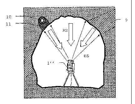
In comparison, a geodetic device 1" according to the
invention permits the scanning of the inner surface of
the same structure with an extended possibility of
analysis, as shown schematically in fig. 6. The
electromagnetic radiation ES emitted by the geodetic
device 1 is sent back by the surface as reflected
radiation RS with spectral information and is received
again by the geodetic device 1".
Depending on the
composition of the surface, there is a change in the
spectrum of the reflected radiation RS compared with
CA 02571716 2006-12-21
13
the emission. Thus,
on the basis of the spectral
distribution or of the harmonic components, it is also
possible to identify structures below the surface. In
this example, the position and extent of a water-
carrying stratum 9 can be recognized from the wetting
of the surface visible in the tunnel. Likewise, liquid
11 emerging from a pipe 10 can be recognized. In a
similar manner, however, rust on reinforcement steel
meshes embedded in reinforced concrete can be
recognized and localized. In combination with marking
substances which have particular
spectral
susceptibility, it is possible according to the
invention also to carry out a search for leaks by
loading the pipe to be investigated with the marking
substance and localizing the point of emergence by
means of a scanner system.
Fig. 7 shows an example of a grey step recording of the
inner surface 2"' of a tunnel with identifiable
structures. The image corresponds to a recording of a
region close to the bottom of the tunnel to the tunnel
ceiling with a registration range of almost 180 . The
continuous white line in the lower image half
represents the high voltage wire of an overhead line.
Dark spots 12 in the grey step recording can be
interpreted, for example, as moist areas.
However,
they may alternatively also be an area of peeling
surface deposit, so that an analysis over and above the
grey step representation is advantageous.
The embodiments of the scanner system according to the
invention or of a geodetic device according to the
invention, shown in the following fig. 8-13, are
CA 02571716 2006-12-21
14
explained in abstract terms with reference to their
substantial components. Details of beam guidance, such
as, for example, elements of transmitting and receiving
optical system, are not shown for reasons of clarity.
Likewise, there is no detailed presentation of scanner
components used for beam guidance or for compensating
effects or artifacts produced by the scanning process.
The individual working examples are only exemplary
possibilities of the realizations with the use of
interchangeable components. In
particular, the
elements and their arrangement can be combined with one
another in the various fig. 8-13.
Fig. 8 shows the schematic diagram of a first working
example with a rotating prism spectrometer 17. A laser
diode as a radiation source, arranged in a distance-
measuring device 20, emits electromagnetic radiation ES
via a deflection mirror 19 and a scanner wheel 13 onto
the surface to be scanned. Here, the scanner wheel 13
shown is typical for a scanning device known per se
from the prior art. After reflection by the surface to
be registered, the radiation is received again as
reflected radiation RS and guided via the scanner wheel
13 and the deflection mirror 19 back to a distance
measuring device which is arranged in the distance-
measuring device 20 and which derives distance
information from the reflected radiation RS, in
particular by the pulse transit time or phase measuring
method.
A first beam splitter 16 which guides a part of the
reflected radiation RS on to the prism spectrometer 17
is present in this beam path. Said
spectrometer has,
CA 02571716 2006-12-21
for example, a rotatable equilateral prism or a star-
like arrangement of prisms or prism surfaces. By
rotation of the prism, the geometric conditions are
continuously changed and the spectral components are
5 passed in succession on to a downstream detector 18 so
that the latter registers a spectrum of the reflected
radiation RS and evaluates it in downstream
electronics. Here,
scanner wheel 13 and prism
spectrometer 17 must be synchronized in their rotation
10 so that a spectral analysis by the prism spectrometer
17 can be effected for each surface point to be
registered. A
second beam splitter 14 outputs a
further part of the reflected radiation RS, which is
guided onto a camera 15, for example a CCD or CMOS
15 camera chip, for image acquisition and processing.
Fig. 9 shows the schematic diagram of a second working
example comprising a grating spectrometer. A radiation
source arranged in a distance-measuring device 20 emits
electromagnetic radiation ES onto the surface to be
scanned via a deflection mirror 19 and a mirror surface
24 pivotable by means of a piezo element 25 about an
axis 26, as scanning device 13'. The mirror surface 24
pivotable for scanning and shown here is typical for a
further scanning device known from the prior art.
After reflection by the surface to be registered, the
radiation is received again as reflected radiation RS
and guided via the pivotable mirror surface 24 and the
deflection mirror 19 back onto a distance-measuring
device arranged in the distance-measuring device 20. A
first beam splitter 16 outputs light from the beam path
onto the grating spectrometer. Said spectrometer has a
grating 21 which is pivotable about an axis 23 and is
CA 02571716 2006-12-21
16
operated in this working example - in particular as a
blazed grating - in reflection. A piezo element 22 is
used as an adjusting device. By
movement of the
pivotable grating 21, the extremes of the various
orders are projected in succession onto a detector 18
so that a spectral analysis can be carried out. A beam
path for a camera 15 is formed parallel to the axis of
the receiving device for the spectrometer and the
distance measuring device.
Depending on sensitivity
and intended use, the camera 15 can use the light of
the radiation source of the distance-measuring device,
a separate light source, e.g. an LED, or daylight for
recording.
According to the invention, it is also
possible to use other types of grating spectrometers,
for example a lamellar grating interferometer or a
grating on a curved and adjustable mirror.
Fig. 10 explains a third working example of a scanner
system according to the invention on the basis of a
schematic diagram. A radiation
source arranged in a
distance-measuring device 20 emits electromagnetic
radiation ES via a dichroic deflection mirror 19' and a
scanner wheel 13 on to the surface to be scanned.
Parallel with this, further electromagnetic radiation
is input into the same beam path via the dichroic
deflection mirror 19', this radiation being produced by
a second radiation source 27. This
second radiation
source 27 may be, for example, in the form of a laser
diode, LED or thermal emitter. After reflection by the
surface to be registered, the radiation is received
again as reflected radiation RS and is guided via the
scanner wheel 13 and the dichroic deflection mirror 19'
back to a distance-measuring device arranged in the
CA 02571716 2006-12-21
17
distance-measuring device 20. A first beam splitter 16
outputs light from the beam path onto a first
spectrally selective receiver, which consists here by
way of example of the combination of detector 31 and
attached spectral filter 30. In an analogous manner, a
second beam splitter 14' outputs light to a second
spectrally selective receiver, which here likewise
consists of detector 29 and attached spectral filter
28. Both
spectrally selective receivers are designed
so that different wavelength ranges are covered. From
the ratio of the registered intensities, estimates or
simple identifications of surface features can be
derived. In
this working example, the infrared
radiation of the radiation source arranged in the
distance-measuring device 20 is supplemented by the
emission of a blue laser diode as second radiation
source 27. The two spectrally selective receivers are
designed to be sensitive in the blue and infrared range
by their coordinated filters. A beam path for a camera
15 is formed axially parallel to the receiving
direction of the scanning wheel 13.
Alternatively,
instead of two detectors with coordinated filters, it
is also possible to use sensors which already have
spectrally narrow-band sensitivities in the relevant
range. It is also
possible to use a single detector
which is designed to be spectrally selective by means
of different, variable filters.
Fig. 11 shows the schematic diagram of a fourth working
example of the scanner system according to the
invention. A
laser diode arranged in a distance-
measuring device 20 emits electromagnetic radiation ES
via a deflection mirror 19 and a scanner wheel 13 onto
CA 02571716 2006-12-21
18
the surface to be scanned, reflected radiation RS being
received via the scanner wheel 13 and the deflection
mirror 19 in a distance-measuring device of the
distance-measuring device 20 after reflection by the
surface to be registered. A first beam
splitter 16,
which guides a part of the reflective radiation RS on
to a Fourier spectrometer in a Michelson arrangement,
is present in this beam path. Said spectrometer has a
lens 32 for collimating the reflected radiation RS and
a splitter plate 33 which guides the radiation on to a
first interferometer mirror 35 and a tilted mirror as a
second interferometer mirror 34. The
radiation is
guided via the splitter plate 33 with superposition
onto a sensor 36, for example a linear or two-
dimensional arrangement of photodiodes, the signals of
which sensor are spectrally resolved in a downstream
computing unit, for example by means of discrete
Fourier transformation.
Instead of the tilting mirror
as second interferometer mirror 34, it is also possible
to use a rotatable Littrow grating which can be moved
by means of a piezo element or a high-precision stepper
motor. This
arrangement with spatial modulation
permits a rapid spectral resolution which also permits
operation with fast scanner movements. For
the
parallel image recording, a further part of the
reflective radiation RS is output from the beam path
via a second beam splitter 14 and is guided onto a
camera 15.
Fig. 12 shows the schematic diagram of a fifth working
example which, in this example, corresponds to the
working example shown in fig. 11, except for the
special type of scanning Fourier spectrometer. In this
CA 02571716 2006-12-21
19
fifth working example, a Fourier spectrometer in the
Michelson arrangement with a lens 32 for collimating
the reflected radiation RS and a splitter plate 33 is
likewise used. The
radiation is guided onto a first
interferometer mirror 35 and a mirror as second
interferometer mirror 38, which can be moved by a piezo
actuator or an electrostatic comb as a drive in the
direction of one arm of the interferometer. By
means
of the splitter plate 33, the radiation is deflected
with superposition onto a sensor 36, for example a
linear or two-dimensional arrangement of photodiodes,
the signals of said sensor being analyzed for spectral
resolution in a downstream computing unit 37.
Fig. 13 shows the schematic diagram of a sixth working
example as an example of the integration of a scanner
system according to the invention into a geodetic
measuring device. In a
theodolite having a scanning
device, a distance measurement to surface points is
carried out within the field of view of the theodolite
by a fixed laser diode 39 and receiving device 46. The
laser diode 39 emits electromagnetic radiation ES via a
deflection mirror element 40 onto a first inclined
surface of a double-sided deflection mirror 41, from
which this radiation is emitted via an objective lens
42 with downstream wedges 43 rotatable relative to one
another as a scanning device. The
radiation received
again via the objective lens 42 after reflection is
guided onto the second surface of the deflection mirror
element 41 by a back-reflecting mirror element 44 and
from there to the fixed receiving device 46. A first
beam splitter 16' which outputs a part of the radiation
onto a Fourier spectrometer comprising lens 32',
CA 02571716 2006-12-21
splitter plate 33' and a first interferometer mirror
35' and a second tilted interferometer mirror 34' is
present in the beam path to the receiving device 46.
In a procedure analogous to the arrangement in fig. 11,
5 the light of the two arms of the interferometer are
superposed and projected onto a sensor 36'. A
downstream computing unit 37' serves for the Fourier
transformation. In
this working example, the scanning
movement of the laserbeam for scanning a surface is
10
effected by the wedges of the alignment means 43 which
are rotatable relative to one another. The
recording
of an image can be effected by a camera 15' arranged in
the beam path after the back-reflecting mirror element
44 and having an upstream focusing member 45.
While in fig. 11 and fig. 13, the - spatially variable
- path difference in the Fourier spectrometer was
produced by tilting of a mirror, in fig. 12 a
longitudinal movement of a mirror was effected, which
movement likewise produced a path difference - now
varying as a function of time.
According to the
invention, however, further Fourier spectrometers can
also be used; thus, it is also possible to use a liquid
crystal for polarization-dependent generation of an
optical path difference in transmission, in particular
with upstream polarization separation comprising
quarter-wave plate and polarizer.