Note: Descriptions are shown in the official language in which they were submitted.
CA 02585141 2012-02-22
1
RELATIVE POSITIONING METHOD AND RELATIVE POSITIONING
SYSTEM USING SATELLITE
TECHNICAL FIELD
The present invention relates to a relative position
measurement method and relative position measurement system
for using radio waves from a plurality of satellites and
detecting a three-dimensional position by relative position
measurement.
BACKGROUND ART
As a satellite position measurement technology for
receiving and analyzing radio waves from a plurality of
satellites and detecting a position of a receiver
(hereafter called "mobile station"), a single position
measurement system for measuring a position by a solo
mobile station even if the measurement error is large, and
a relative position measurement system for accurately
determining the position of a mobile station using the
correction data from a reference station of which position
is known, are available.
In the relative position measurement system, the
position measurement accuracy is restricted by the linear
distance between receivers, which is the so called "base
line length".
For example, in the case of a relative position
measurement system which measures the position
independently using the C/A code of GPS (Global Positioning
System) and correcting the position using correction data,
the limit of the base line length, when the uncertainty of
the orbit information of the satellite and the error due to
the ionosphere and atmosphere or the like are approximately
the same for each receiver, is about 100 km or less, and an
error can be canceled within this range, so an improvement
CA 02585141 2007-04-23
2
of the position measurement accuracy in the relative
position measurement system can be expected.
On the other hand, in the case of a system which
analyzes the base line using a carrier phase so as to
improve the position measurement accuracy, the limit of the
base line is short, about 10 km or less, but the position
measurement accuracy improves dramatically since a carrier
phase, which is sufficiently shorter than the C/A code, is
used [e.g. see the new edition of GPS - Precision
Positioning System by Satellites, (issued by Japan Survey
Association)].
Any of the above-mentioned relative position
measurement systems, however, can be used in the range of
the base line limit length from the reference station and
in the area where the reference station is not organized,
the relative position measurement cannot be used no matter
where the mobile station is located, whether on land, ocean
or in the sky, so position cannot be measured accurately.
DISCLOSURE OF THE INVENTION
To solve the above problem, it is an object of the
present invention to provide a relative position
measurement method and a relative position measurement
system using satellites that can use relative position
measurement, even for a mobile station located outside the
range of the base length that allows relative position
measurement.
The relative position measurement method using
satellites according to the present invention is a position
measurement method for forming a relative network for
performing a relative position measurement between
predetermined stations by receiving radio waves from
satellites by a reference station and a plurality of mobile
stations, and measuring a reference relative position,
which is a relative position of each mobile station viewed
CA 02585141 2012-02-22
3
from the reference station, wherein at least one of the
mobile stations is disposed so as to exceed a base line
limit length that allows relative position measurement with
the reference station, and a space between predetermined
mobile stations is set to be a base line limit length that
allows relative position measurement or set to be less than
the base line limit length, the relative position
measurement method comprising: a reference relative position
computing step of computing a reference relative position
between the reference station and the predetermined mobile
station; an inter-mobile station relative position computing
step of computing an inter-mobile station relative position,
which is a relative position between the predetermined
stations; and a conversion step of converting the
inter-mobile station relative position between a mobile
station for which the reference relative position is
determined and a mobile station that performs relative
position measurement into a reference relative position
using a reference relative position of a remote station.
The relative position measurement system of the
present invention is a position measurement system for
forming a relative position measurement network for
performing a relative position measurement between
predetermined stations by receiving radio waves from
satellites by a reference station and a plurality of
mobile stations, and measuring a reference relative
position, which is a relative position of each mobile
station reviewed from the reference station, wherein at
least one of the mobile stations is disposed so as to
exceed a base line limit length that allows relative
position measurement with the reference station, and a space
between predetermined mobile stations is set to be a base
line limit length that allows relative position measurement
or set to be less than the base line limit length, a
satellite position measurement device for receiving radio
waves from satellites is installed in each of the
CA 02585141 2007-04-23
4
stations, a radio communication device for transmitting and
receiving data to/from a predetermined station is installed
in each of the stations, and the relative position
measurement system is provided with a relative position
computing section for computing a relative position between
the predetermined stations, and a reference relative
position computing section for determining a reference
relative position of another mobile station based on a
reference relative position of one station that performs
the relative position measurement.
It is preferable that the reference relative position
computing section in the relative position measurement
system is disposed in the reference station, and the
reference relative position of the mobile station is
sequentially determined.
It is also preferable that the reference relative
position computing section for computing each reference
relative position is disposed in each mobile station in the
relative position measurement system.
It is also preferable that the relative position
measurement in the relative position measurement system is
performed using a carrier phase.
According to the relative position measurement method
and relative position measurement system, a network which
sequentially places mobile stations from a reference
station with a predetermined space so as to be less than a
base line limit length that allows relative position
measurement and performs relative position measurement
continuously, is formed, and the relative position between
each station is determined, and also the reference relative
position of each mobile station from the reference station
is sequentially determined using the reference relative
position of a mobile station which performs relative
position measurement with the reference station, so the
relative position of a mobile station which is distant from
CA 02585141 2007-04-23
the reference station, more than the base line limit length
that allows relative position measurement, can be more
accurately determined by the relative position measurement
via the mobile station disposed there between.
For example, by disposing each mobile station on a
floating body located on a sea surface in a sea area
distant from the reference station on the land, the coming
of a tsunami can be known at a sea area distant from the
coast line based on the time-based displacement of the
position of each mobile station, and tsunami related damage
can be minimized.
BRIEF DESCRIPTION OF THE DRAWINGS
Fig. 1 is a perspective view depicting an entire
configuration of the relative position measurement system
according to Embodiment 1 of the present invention;
Fig. 2 is a block diagram depicting a general
configuration of a reference station in this relative
position measurement system;
Fig. 3 is a block diagram depicting a general
configuration of a mobile station in this relative position
measurement system;
Fig. 4 is a block diagram depicting a general
configuration of a position measurement computing device
installed in the mobile station;
Fig. 5 is a flow chart depicting the relative position
measurement method in the relative position measurement
system;
Fig. 6 is a block diagram depicting a general
configuration of the position measurement computing device
installed in a mobile station of the relative position
measurement system according to Embodiment 2 of the present
invention;
Fig. 7 is a flow chart depicting the relative position
measurement method in the relative position measurement
CA 02585141 2007-04-23
6
system;
Fig. 8 is a block diagram depicting a general
configuration of a reference station according to a variant
form of the relative position measurement system of each
embodiment; and
Fig. 9 is a block diagram depicting a general
configuration of a relative position measurement computing
device installed in the reference station according to a
variant form of the relative position measurement system of
each embodiment.
BEST MODE FOR CARRYING OUT THE INVENTION
A relative position measurement system and relative
position measurement method using satellites according to
the present invention will now be described.
In the present embodiment, a real-time kinematic
system using GPS (Global Positioning System) satellites
that is used as the relative position measurement system
using satellites, and a case of measuring an absolute
position with setting a reference station at a known
absolute position when a relative position of a floating
body moored on the sea surface for detecting the
displacement of the sea level, viewed from the reference
station, is determined as the position measurement target
will be described.
[Embodiment 1]
The relative position measurement system and relative
position measurement method using satellites according to
Embodiment 1 will now be described with reference to Fig. 1
to Fig. 5.
As Fig. 1 shows, this relative position measurement
system comprises a reference station 1 fixed on a land of
which the absolute three-dimensional position is known, and
a plurality of mobile stations 3 installed on a plurality
CA 02585141 2007-04-23
7
of floating bodies (buoy) 2 sequentially moored on a sea
surface with a predetermined space from the center of the
reference station 1 to offshore in a sea area, where the
displacement of sea level viewed from the reference station
1 is to be detected, and each station 1 and 3 has a
function for determining a relative position of each mobile
station 3 by receiving radio waves from GPS satellites 4
and using the real-time kinematic system (which uses a
carrier phase, and is hereafter called the "RTK system").
For each mobile station 3, one closest to the
reference station 1 is called the "first mobile station 3A",
and the one second-closest to the reference station 1 is
sequentially called the "second mobile station 3B", then,
third mobile station 3C, . . . " and the one most distant
from the reference station 1 is called the "nth mobile
station 3Z".
As mentioned above, each station is disposed with a
predetermined space, and, for example, the space between
the reference station 1 and the first mobile station 3A,
between the first mobile station 3A and the second mobile
station 3B, between the second mobile station 3B and the
third mobile station 3C, . . and between the n-ith mobile
station 3Y and the nth mobile station 3Z are set to be the
base line length, which allows position measurement in an
RTK system (hereafter called the "base line limit length",
which is 10 km, for example) or less, and a relative
position measurement network is formed among the stations
with the reference station to perform the relative position
measurement upstream, and at least the mobile station 3,
the most distant from the reference station 1, is installed
on a floating body 2 at a position which exceeds the base
line limit length from the reference station 1. And for
certain the space between each station may be a same length
or a different length, as long as it is the base line limit
length which allows position measurement in an RTK system
CA 02585141 2007-04-23
8
or less.
As shown in Fig. 2, the reference station 1 comprises
a GPS receiver (an example of a satellite position
measurement device) 11 for receiving radio waves from the
GPS satellite 4 via the antenna lla and measuring the
satellite data for position measurement, and a radio
communication device (further comprises a transmitter and
receiver) 12 which transmits/receives various data,
including the satellite data for position measurement
measured by the GPS receiver 11, with another mobile
station 3.
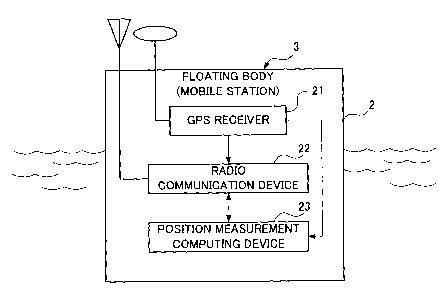
As shown in Fig. 3, each mobile station 3 comprises a
GPS receiver (an example of a satellite position
measurement device) 21 for receiving radio waves from the
GPS satellite 4 and measuring the satellite data for
position measurement, a radio communication device (further
comprises a transmitter 22a and receiver 22b, as shown in
Fig. 4) 22, which transmits/receives data with other
stations 1 and 3, and a position measurement computing
device 23 for receiving data from the other stations 1 and
3 and performing relative position measurement using an RTK
system based on the data of the same time in the local
station, that is, determining the relative displacement of
another station from one station.
Now the position measurement computing device 23
installed in the mobile station 3 will be described in
detail.
As shown in Fig. 4, the position measurement computing
device 23 comprises a data storage section 31 for storing
satellite data for position measurement measured by the GPS
receiver 21 (including a carrier phase value, distance
between satellite and antenna of the receiver (pseudo-
distance), orbit information of the satellite, time series
data (GPS time) used for the satellite position measurement
system, and, for example, elevation angle and azimuth of
CA 02585141 2007-04-23
9
the satellites during receiving), a relative position
computing section 32 for inputting the satellite data for
position measurement obtained in the GPS receiver 21,
satellite data for position measurement from the reference
station 1 or previous mobile station (mobile station closer
to the reference station in the network (upstream side),
hereafter called "previous station") 3, and a temporary
fixed position (hereafter called "temporary coordinates")
of the previous station, via the receiver 22b, and
computing the relative position from the previous station
using the RTK system, an absolute position computing
section 33 for inputting the relative position determined
by the relative position computing section 32 and the
absolute position of the previous station and computing
the absolute position of this mobile station 3, and a
transmission data creation section 34 for inputting the
satellite data for position measurement of the mobile
station 3 stored in the data storage section 31, that is,
of the local station, the temporary coordinates of the
location station and the absolute position determined by
the absolute position computing section 33, and creating
the transmission data to be sent to the next mobile station
3. For certain the transmission data created by the
transmission data creation section 34 is sent to the next
mobile station 3 via the transmitter 22a. Among the
satellite data for position measurement, the orbit
information, elevation angle and azimuth, for example, are
received by the two stations which perform relative
position measurement respectively, so if the data is
obtained only by the GPS receiver 21 of one station, the
data may be transferred to the other station and used,
since both the elevation angle and azimuth are
approximately the same for these two stations.
The data used for relative position measurement is
acquired from the data storage section if necessary.
CA 02585141 2007-04-23
In the above configuration, if an absolute position is
not provided to the reference station 1, the absolute
position computing section 33 becomes the reference
relative position computing section. In this case, if the
previous station is a mobile station, the reference
relative position is input from the previous station to
this reference relative position computing section.
Now a method for measuring the absolute position of
each mobile station by determining a relative position
between each station in this relative position measurement
system and measuring a displacement of the sea level will
be described with reference to the flow chart in Fig. S.
First the satellite data for position measurement, in
which the temporary coordinates and the absolute position
of the reference station 1 on the land are sent to the
first mobile station 3A on the sea level (step 1).
Then in the first mobile station 3, the relative
position (reference relative position) viewed from the
reference station in the temporary coordinates is
determined between the reference station 1 and the first
mobile station 3A using the relative position measurement
based on the RTK system (step 2: reference relative
position computing step).
Then the absolute position of the first mobile station
3A is determined using the absolute position (absolute
coordinates) and relative position of the reference station
1 (step 3).
Then the absolute position and temporary coordinates
(fixed coordinates) of the first mobile station 3A and the
satellite data for position measurement are sent to the
second mobile station 3B.
Then in the second mobile station 3B, the relative
position measurement based on the RTK system is performed
between the first mobile station 3A and the second mobile
station 3B using the temporary coordinates and the
CA 02585141 2007-04-23
11
satellite data for position measurement, and the relative
position (inter-mobile station relative position) of the
second mobile station 3B viewed from the first mobile
station 3A is determined (step 5: inter-mobile station
relative position computing step).
Then the difference between the temporary coordinates
of the first mobile station 3A and the absolute position
thereof (true coordinate value) is determined and is added
to the inter-mobile station relative position determined in
step 5, and the absolute position of the second mobile
station 3B is determined (step 6: displacement step).
When the absolute position of the second mobile
station 3B is determined, the above mentioned steps 4 to 6
are repeated, and the absolute position of the third mobile
station 3C is determined, and this procedure is repeated
until the absolute position of the nth mobile station 3Z,
which is the most distant from the reference station, is
determined. In this repeating section (steps 4 to 6), the
previous station is indicated as (i-i), and the mobile
station, for which absolute position is determined based on
the relative position measurement is indicated as (i).
Therefore once the absolute position of each mobile
station 3 is determined, this means that the displacement
of the floating body 2, that is, the displacement of the
sea level at every predetermined cycle, is measured, and
the waves can be accurately measured by the water level
fluctuation of the sea surface, and by removing the wave
component and the tidal component from the displacement of
the sea level, a tsunami generated by an earthquake, for
example, can be accurately measured.
In the above mentioned method, the absolute position
of the reference station is provided, and is converted into
the absolution position of the second mobile station in
step 6, but if the absolute position is not provided, the
difference between the temporary coordinates of the first
CA 02585141 2007-04-23
12
mobile station 3A and the reference relative position
thereof is determined, and the reference relative position
of the second reference station 3B is determined. To
detect waves and tsunami, it is not always necessary to
determine the absolute position.
In brief, the relative position measurement method of
the present invention is a position measurement method for
forming a relative network for receiving radio waves from
satellites by a reference station and a plurality of mobile
stations, and performing relative position measurement
between predetermined stations, and measuring a reference
relative position, which is a relative position of each
mobile station viewed from the reference station, wherein
at least one of the mobile stations is disposed so as to
exceed a base line limit length which allows relative
position measurement with the reference station, and a
space between predetermined mobile stations is set to be
the base line limit length which allows the relative
position measurement or less, and this position measurement
method has a reference relative position computing step for
computing a reference relative position between the
reference station and a predetermined mobile station, an
inter-mobile station relative position computing step for
computing an inter-mobile station relative position, which
is a relative position between the predetermined stations
(corresponding to step 2), and a conversion step of
converting the inter-mobile station relative position of
the mobile station for which the reference relative
position is determined and the mobile station which
performs the relative position measurement, into the
reference relative position using the reference relative
position of the remote station (corresponding to step 6).
In this way, the reference station 1, of which
absolute position is known, is disposed on land, and the
mobile stations 3 are sequentially disposed on the sea
CA 02585141 2007-04-23
13
surface from the reference station 1 with a predetermined
space, so as to be the base line limit length which allows
relative position measurement based on the RTK system or
less, and the relative position between each station is
determined by the RTK system, and using this relative
position, the absolute position of each mobile station with
respect to the reference station is determined, so the
absolute position of the mobile station 3, which is distant
from the reference station 1 more than the base line limit
length which allows relative position measurement, can be
accurately determined via the mobile stations 3 disposed
therebetween based on the RTK system.
Therefore by disposing each mobile station on a
floating body on the sea surface in a sea area distant from
the reference station, the existence of a tsunami can be
known well before reaching shore, so tsunami related damage
can be minimized.
[Embodiment 2]
Now the relative position measurement method and
relative position measurement system using satellites
according to Embodiment 2 will now be described with
reference to Fig. 6 and Fig. 7.
In Embodiment 1, the temporary coordinates are used
when relative position measurement is performed between
each station, but in Embodiment 2, the absolute positions
of the reference station and the previous station are used,
and therefore in the following description, only this will
be focused on and described, and composing elements the
same as Embodiment 1 will be denoted with the same
reference numbers, for which description will be omitted.
As Fig. 6 shows, in the position measurement computing
device 23' disposed in each mobile station 3, the satellite
data for position measurement from the previous station and
absolute position of the previous station are input to the
CA 02585141 2007-04-23
14
absolute position computing section 32', and the absolute
position of the target mobile station 3 of position
measurement is directly determined in the absolute position
computing section 32'. Therefore the absolute position
computing section 32' of Embodiment 2 is the relative
position computing section 32 of Embodiment 1, in which the
function of the absolute position computing section 33 is
integrated.
A method for measuring the absolute position of each
mobile station 3 in this case will now be briefly described
with reference to the flow chart in Fig. 7.
First the satellite data for position measurement of
the reference station 1 on land and the absolute position
thereof are sent to the first mobile station 3A on the sea
surface (step 1).
Then in the first mobile station 3, the relative
position measurement is performed between the reference
station 1 and the first mobile station 3A based on the RTK
system, and the relative position is determined (step 2).
Then the absolute position of the first mobile station
3A and the satellite data for position measurement are sent
to the second mobile station 3B (step 3).
Then in the second mobile station 3B, the relative
position measurement based on the RTK system is performed
between the first mobile station 3A and the second mobile
station 3B using the satellite data for position
measurement, and the absolute position is determined (step
4).
When the absolute position of the second mobile
station 3B is determined, the above mentioned steps 3 to 4
are repeated, and the absolute position of the third mobile
station 3C is determined, and this procedure is repeated
until the absolute position of the nth mobile station 3Z,
which is the most distant from the reference station is
determined. In this repeating section (steps 3 to 4), the
CA 02585141 2007-04-23
previous station is indicated as (i-1), and the mobile
station, for which absolute position is determined based on
the relative position measurement, is indicated as (i).
Therefore in Embodiment 2 as well, an effect the same
as Embodiment 1 is obtained.
In each of the above embodiments, the position
measurement computing device is disposed in each mobile
station, and the absolute position of each mobile station
is determined, but these absolute positions are transmitted
along with a station number to an observatory (may also be
used as a reference station) on land by the transmitter 22a,
and centrally controlled there.
On the other hand, the position measurement computing
device may be disposed in the reference station, for
example, so that the satellite data for position
measurement, measured in each mobile station, is
transmitted to and stored in the reference station, and the
absolute position of each mobile station may be determined
by the position measurement computing device of the
reference station.
In other words, the inter-mobile station transmission
data is transmitted to the reference station, and the data
of each mobile station is stored in the reference station,
and the absolute position of each mobile station is
determined in the absolute position computing section using
this data.
In this case, the reference station 1 comprises a
position measurement computing deice 13, as shown in Fig. 8,
and the position measurement computing device 13 further
comprises a data storage section 41 for storing at least
satellite data for position measurement from the GPS
receiver 11 and the satellite data for position measurement
received by each mobile station 3 via the receiver 12b of
the radio communication device 12, and an absolute position
computing section 42 for inputting the satellite data for
CA 02585141 2007-04-23
16
position measurement stored in this data storage section 41,
and computing the absolute position of each mobile station
3 with respect to the reference station 1, as shown in Fig.
9.
In the description of the above embodiments, data is
transmitted/received between each station by the radio
communication device, but if communication by ground waves
cannot be performed due to visual limitation, data can be
transmitted/received via the communication satellite.
Also in the above embodiments, the reference station
is disposed on land, but also may be disposed on a floating
body floating on the sea surface.
Also in the description of the above embodiments, the
reference station is disposed on land and the mobile
stations are disposed on the sea surface so as to measure
waves and tsunami, but if both the reference station and
mobile stations are disposed on land, the relative position
measurement system can also be used as a seismograph, for
example.
Also in the above embodiments, satellite measurement
based on GPS was used as an example, but the present
invention can also be applied to a satellite position
measurement system based on the same principle, or which
will appear in the future.
INDUSTRIAL APPLICABILITY
According to the relative position measurement method
and relative position measurement system of the present
invention, accurate position measurement is possible using
a relative position measurement based on a real-time
kinematic system, even for a mobile station installed at a
position exceeding the base line limit length which allows
relative position measurement from the reference station,
and by mooring a floating body, on which a mobile station
is installed, in a sea area quite distant from land, for
CA 02585141 2007-04-23
17
example, a tsunami can be measured offshore and its coming
can be forecasted, and the tsunami related damage can be
minimized. In some cases, the relative position
measurement system can also be used as a seismograph.