Note: Descriptions are shown in the official language in which they were submitted.
CA 02589998 2013-03-13
1
Hand-held surveying device and surveying method for such a
surveying device
The invention relates to a hand-held surveying device and a
surveying method for such a surveying device
In many applications, methods and systems for distance
measurement are used.
Examples of this are extremely
precise surveys in geodetic applications, but also measuring
tasks in the area of building installation or for military
purposes.
For these tasks, hand-held surveying devices
which carry out an optical distance measurement to a
selected field point are used. Here, generally a laser beam
is emitted and is received again and evaluated after
deflection by the target.
Various measuring principles,
such as, for example, phase or transit time measurement, are
available for determining the distance.
A typical surveying device suitable for such applications is
described, for example, in European Patent Publication No.
EP 0 738 899 Bl.
In many applications, it is desirable to carry out distance
measurements which are automatically associated with the
position and/or orientation of the measurement.
This
results in easier handling since there is no need for
repeated fixing of the measuring device to a reference
point.
For example, US Patent No. 5,337,149 discloses a hand-held
rangefinder with inertial sensors, which links the distance
measurement to the actual position.
US Patent No. 5,886,775 describes a scanning process for an
object. The position determination of the hand-held scanner
used is effected here electromagnetically.
Although such distance-measuring systems permit the linking
of distance measurement and determination of spatial
CA 02589998 2013-03-13
2
variables, such as position and orientation, at the time of
measurement, the recording of larger numbers of
measurements, as required, for example, in the scanning of
extensive objects, remains problematic.
This is the case, for example, if the distance between two
edges of a table is to be measured without contact being
possible. In addition, even with suitable measuring points,
access for the measurement is not always available. Thus,
for example, measurement of pipelines running along a high
ceiling with regard to their thickness is not possible by
means of surveying devices of the prior art. However, these
objects and their properties can be surveyed from a
relatively large number of measurements if they are
determined with respect to their measuring conditions and
have a cohesion as a spatial sequence of starting points of
the measurement.
The disadvantage of apparatuses to date is the poor
coherence or the lack of spatial relationship of the various
measurements, in particular the uniformity of the
distribution of starting locations of the measurements.
Thus, a plurality of distance measurements are not
automatically correlated with one another on recording.
However, such correlations are suitable, for example, for
checking the parallelism of two structures, such as, for
example, two walls. A fundamental problem of such a linkage
is due to the multiplicity of measurements which in each
case have to be separately oriented and initiated, but all
measurements should advantageously have a spatial cohesion,
i.e. must be carried out with close spatial coordination
with one another or adjacent to one another.
An aspect is to permit a high spatial cohesion of a
plurality of measurements, in particular of a multiplicity
of measurements, for hand-held surveying devices or methods.
A further aspect is to provide a hand-held surveying device
and a surveying method suitable for this purpose, by means
CA 02589998 2013-03-13
3
of which properties of extensive or three-dimensional
structures can also be surveyed or checked or structures can
be identified.
The basis of the invention is that distance measurements are
recorded automatically and with linkage together with the
coordinated parameters of the location and the orientation
of the axis of the rangefinder. The recorded data records
comprising distance and coordinated parameters can then be
directly further processed or temporarily stored.
The
recording of the data records is effected by an automated
measuring sequence.
By initiating the measurement, a
sequence of distance measurements with associated
orientation and position determination is generated by the
device.
The repetition rate is chosen so that a dense sequence of
measurements arises whose frequency and spatial relationship
permit determination of surfaces too by scanning.
The
scanning is effected here by manual movement of the
measuring device, it being possible for this movement to
include arbitrary and involuntary components.
In
particular, the use of the physiological tremor of the human
hand permits fine scanning if the measurements are initiated
with appropriate adaptation. Depending on the distance, the
tremor can be used as the only movement of the hand in order
to scan relatively small targets so that the scanning
determination is effected without arbitrary movement.
By means of the automated and optionally optimized
recording, data sets for a multiplicity of distance
measurements are recorded rapidly and precisely and can
subsequently be evaluated by more complex methods, for
example also statistical approaches or methods of pattern
detection.
The repetition rate of the automatically generated
CA 02589998 2013-03-13
4
measurements can be adapted as a function of target distance
or changes in position or in orientation.
Thus, for
example, the "density" or time sequence of the measurements
can be varied as a function of the target distance and/or
the manual scanning speed. Optionally however, it is also
possible to take into account information about the scanned
target object.
If, for example, the continuously recorded
distance measurements show a large scatter of the distance
values, a structured surface may be assumed and the
repetition rate can be increased for achieving higher
resolutions.
If the variance of the measured values then
falls below a threshold again, the repetition rate can be
correspondingly reduced.
In a similar manner, the
repetition rate can be varied as a function of the angular
acceleration or lateral movement of the measuring device in
order to maintain a correspondingly uniform or dense
coverage.
The distance measurement can be carried out using the laser
rangefinders typically used in hand-held surveying devices.
In principle, however, it is also possible according to the
invention to use other systems provided that they permit
identification and spatial allocation of the surveyed points
to the surveying device, such as, for example, triangulation
meters.
For each distance measurement, the orientation of the beam
path used for this purpose and the position of the surveying
device are recorded. The determination of orientation and
position can be effected by various methods. In particular,
according to the invention, the change in the orientation
and position can be determined so that only relative
parameters are measured. These must be related back to the
starting point of the entire measuring method when an
absolute determination is required. In many
applications,
however, an absolute position of the parameter to be
obtained is not required. Thus, in the case of the above-
described measurement of the distance between two edges, it
is sufficient to determine only the edges and their distance
CA 02589998 2013-03-13
and position relative to the surveying device. From the set
of measurements which are spatially related to one another,
the spacing of the edges can be calculated. An automated
reference to a known absolute position is not required in
5 this case since the allocation of distance to object is
effected by the user.
Thus, it is sufficient for many
purposes if the measurements are known with regard to their
position and orientation to one another.
According to the invention, it is of course also possible to
determine the absolute position or orientation in space for
each measurement or a few measurements so that the
measurements are not only correlated with one another but
are also exactly fixed in space.
This permits subsequent
use in a further measuring sequence independent of the first
series or the transfer to other systems.
The method according to the invention provides a large
number of correlated measurements so that even more complex
evaluation methods can be used. For example, it is possible
by known methods to identify objects in a point cloud of
individual measurements and to determine the dimensions or
orientation of said objects.
Such methods are described,
for example, in PCT Publication No. WO 97/40342.
To date, however, such point clouds were recorded by fixed
scanner systems.
For these systems, it was necessary to
choose a fixed erection point which served as a basis of a
scanning process effected by motors. Complexity, size and
energy consumption prohibited such hardware for hand-held
operation, as did the requirement of fixed erection.
According to the invention, the present invention uses the
movement of the hand for achieving a scanning measuring
process. Here, both the tremor as an involuntary movement
of the hand which is present in any case and a conscious
movement are used for achieving a manual scanning process.
Depending on the application, different frequencies of the
CA 02589998 2013-03-13
6
tremor may occur.
The normal, physiological tremor has
frequencies in the range of 4 to about 12 Hz, depending on
conditions such as, for example, in the case of rest tremor,
kinetic tremor, holding tremor or isometric tremor, the
physiological tremor in young people being in the range of
8-12 Hz. A repetition rate of the distance measurements and
position and orientation measurements linked therewith which
corresponds to the tremor frequency or exceeds it already
utilises the involuntary movements of the hand for the
scanning determination.
In addition to the scanning movement of the hand, a scanning
movement of the beam used for the distance measurement can
be technically produced. This can be effected, for example,
in a fan-like or funnel-like manner and can be produced, for
example, by piezoelectrically moved elements in the beam
path.
In addition to the manually generated scanning
movement, there is a superposed scanning emission generated
by the apparatus or one having a plurality of measuring
lobes which permit the production of parallel or zig zag
traces of measuring points on the target object and hence
improved scanning.
The scanning movement produces a continuous change in the
emission direction and the position of the surveying device.
The parameters to be determined for each distance
measurement can be determined by internal systems which
determine the relative variables as changes of reference
variables or as acting forces or accelerations.
This is
possible, for example, with inertial sensors. These measure
rotational and translational accelerations. As a result of
the integratability on substrates, for example by known
methods of microsystem engineering, for example by micro- or
nanostructuring, compact, robust and energy-saving sensor
systems which permit use in hand-held surveying systems are
now available.
Inertial sensors have in particular the advantages of a high
usable frequency so that good resolution with respect to
CA 02589998 2013-03-13
7
time and hence also space can be achieved. In addition, the
surveying device can be used without a visual connection to
identifiable points and the device may have a closed,
encapsulated design.
Alternatively or in addition, however, orientation relative
to external variables, for example identifiable points or
structures, is also possible.
If the position of these
reference points determined by the surveying device is
known, the actual absolute position of this device can be
deduced.
In order to permit the actual position as the
present location of the surveying device under all
conditions with the required accuracy, methods are known
which are based on a determination of the position of the
device itself with respect to objects as reference objects
or reference points which are known with regard to their
position.
An example of this is the classical method of
resection.
If it is intended to derive absolute positions
for a surveying device or a positioning device suitable for
this purpose from the knowledge of reference points, the
reference points must be established beforehand and surveyed
with sufficient accuracy.
However, even without a knowledge of the absolute position
of these reference points, it is always possible to consider
the relative position, i.e. the change referred to these
points, so that a relative positioning or orientation of the
measuring axis is possible, which permits correlation of the
various distance measurements.
Systems suitable for this purpose are known, for example, by
the name local positioning systems and use microwaves or
optical radiation for measurement relative to the reference
points.
Such a system comprising an optical determination
of external reference points is described, for example, in
the European patent publication no. 1517117.
The advantage of the externally referencing systems is in
particular their ability to determine the absolute position.
CA 02589998 2013-03-13
8
According to the invention, an inertial sensor can also be
combined with an externally referencing system in a
surveying device, even if this does not have the required
resolution of the respective space or time. Thus, inertial
sensors which measure, for example, rotation rates and
linear accelerations frequently have drifts which lead to
deviation of the measured actual position from the true
position.
A surveying device according to the invention
then offers a suitable correction function which corrects
deviations at certain time intervals by external
determinations of the actual position. On the other hand,
periods between the low-frequency steps of the external
positioning system can be supported by a position
determination by means of inertial sensors. The
intermittent loss of the determination of reference points
can also be bridged by a further positioning system so that
either the number of reference points can be reduced and/or
the range accessible to measurements can be briefly
extended. Such a hybrid system can thus also compensate the
brief loss of a visual connection to reference points, so
that the area of use is generally enlarged and the surveying
device is more robustly designed with regard to its use.
The measurements which can be linked or are correlated with
one another in such a manner via the position and
orientation information can, according to the invention, be
evaluated by a multiplicity of approaches, for example from
image processing, pattern recognition or signal processing
and statistical methods.
Below, two examples typical of general applications in the
construction sector or the surveying of buildings are
explained in more detail.
A.
Surveying of a raised structure bounded by edges, for
example a table top
In a first step, the automatic measurement of multiple
CA 02589998 2013-03-13
9
distances is effected, the surveying device being moved
coarsely over a solid angle which includes the table top.
The sequence of measurements is automatically generated, it
being possible to initiate the sequence manually or
automatically. A frequency or repetition rate is specified
or automatically adapted, for example on the basis of the
speed of lateral or rotational movement.
From the set of measurements, the edges are now determined
in a second step. These can be identified automatically,
for example on the basis of jumps in the measured distances,
or manually. The manual identification can be effected, for
example, by carrying out a plurality of measurements
directly to the edge, which are identified additionally as
edge measurements.
From these measurements, a three-
dimensional edge position is then determined, for example by
calculating the mean value.
In a third step, a distance is determined from the three-
dimensional edge position and output as the width of the
table top.
In these steps, it is possible in each case to use
different, known statistical methods in order to obtain a
distance with a pre-determined accuracy from a multiplicity
of measurements.
The recording of the measurements can also be controlled by
taking into account a preliminary estimate of the accuracy
to be achieved with the results. Thus,
in the case of
unfavourable conditions, it is possible to indicate to the
user that the number of measurements is not yet sufficient
and the measuring process must be extended. Alternatively
or in addition, an automatic adaptation of the repetition
rate or measuring frequency can also be effected.
The edge identified in the surveying of a table top,
described here by way of example, and determined with
respect to its three-dimensional position can be used in
CA 02589998 2013-03-13
further steps in order to identify or to define complete
objects. If a plurality of edges are surveyed in succession
as structural elements the position and orientation of the
structural elements is also known or can be derived from the
5 positional and directional information linked to the
measurement, so that related objects can be constructed or
recognised. For example, the above-cited methods of image
processing or of laser scanner technology are available for
this purpose.
B.
Surveying of a surface with regard to its planarity,
for example of a wall in an interior
For surveying the surface, the first step of the example
described above is carried out analogously.
From the totality of the measurements, the flatness of the
wall can then be derived in a second step directly
statistically or in stages.
For the direct statistical
determination, for example, it is possible to use the least
squares method, which places a plane through the cloud of
measured values and minimizes the deviation of the measured
values from this plane. The flatness of the plane can be
concluded from the mean deviation.
The plane is thus
defined as running between the steps.
In a multistage method, for example, it is possible first to
determine the path of an abstract plane, which is effected,
for example, so that all measured values lie spatially on
that side of the plane which faces the rangefinder.
The deviation of the measured values from the ideal, virtual
path of the plane is then derived and the flatness of the
plane thus determined.
In most applications, it is likely to be advantageous if
preliminary information about the topology to be analysed is
specified or automatically determined before the evaluation.
A specification can be effected, for example, by manual
CA 02589998 2013-03-13
11
selection from a menu which has for the above examples the
points "determine width" or "planarity of a plane", so that
a procedure in the analysis or mathematical algorithm is
already defined.
Alternatively or in addition, automated provision of
preliminary information can also be effected.
Thus, the
surveying device may contain an image-recording component
for supporting an allocation of objects to the distance
measurements, for example in the form of a camera. In
relation to the measurements, an image of the surveyed
segment of space is recorded, from which the topology of the
object to be surveyed is then automatically derived.
Efficient algorithms or apparatuses for pattern detection
are available for this purpose in the prior art.
Determination of the objects interactively from the image
information and the measured results can also be effected
here.
Thus, for example, jumps in the measured distances
can be used for identification of edges in a recorded image.
On the basis of the automated linkage of measurements in
dense sequence, the surveying device or surveying method
according to the invention can be used in particular for
determining, verifying and/or measuring angles between
planes, distances between edges or bounding surfaces of
three-dimensional objects, properties of three-dimensional
objects, parallelisms of surfaces or planarities of
surfaces.
The surveying device according to the invention and a
surveying method according to the invention are described in
more detail or explained purely by way of example below with
reference to working examples shown schematically in the
drawing. Specifically,
Fig. la-b show the outside view of two possible
embodiments of the surveying device according
to the invention comprising inertial sensors
and external referencing;
CA 02589998 2013-03-13
12
Fig. 2a-b show the diagram of the design of two
possible embodiments of the surveying device
according to the invention comprising
inertial sensors and external referencing;
Fig. 3 shows the explanatory diagram of the
surveying method according to the invention;
Fig. 4 shows a first example of surveying by the
surveying method according to the invention;
Fig. 5 shows an explanatory diagram for the
derivation of a variable to be measured for
the first example of surveying.
Fig. 6 shows a second example of surveying with the
surveying method according to the invention;
Fig. 7 explains a third example of surveying by the
surveying method according to the invention;
Fig. 8 shows a fourth example of surveying by the
surveying method according to the method;
Fig. la-b show the outside view of two possible embodiments
of a surveying device according to the invention comprising
inertial sensors and external referencing.
The first
embodiment la of the surveying device in Fig. la uses one or
more inertial sensors as a position detection component and
has a housing 2a which carries input and control keys 3a and
a display field 4a on its surface as controls. By means of
these controls, the functionality of the surveying device
can be controlled; in particular, a choice of standard
objects can be made. For
distance measurement, the
surveying device has a radiation source which emits
measuring radiation MS.
Fig. lb shows a second embodiment lb of the surveying device
CA 02589998 2013-03-13
13
according to the invention comprising a position
determination by referencing with respect to external,
identifiable points.
For this purpose, radiation for
identifying and surveying identifiable reference points is
emitted via a cover 5 which is transparent to radiation and
is mounted on the housing 2b of the surveying device. Thus,
an optical system which references itself with respect to
external points is used as a position detection component.
Input and control keys 3b and a display field 4b are
arranged on the surface of the housing as controls. For
distance measurement, measuring radiation MS is emitted.
Instead of the distance measurement with radiation emission,
however, another suitable rangefinder, for example a
triangulation meter, can also be used according to the
invention for all embodiments.
Fig. 2a-b schematically show the internal design of the two
possible embodiments of the surveying device according to
the invention from Fig. la-b comprising inertial sensors and
external referencing.
The design of the first embodiment la is explained in Fig.
2a. The housing 2a carries input and control keys 3a and a
display field 4a on the top. An
inertial sensor 6 as a
position detection component and a computing unit 7 for
control, in particular automatic initiation of the distance
measurement, and for derivation of a variable to be
measured, in particular a distance, from the measured
distances are present inside the housing 2a. For
the
distance measurement, in this first embodiment la measuring
radiation MS is produced by a radiation source 8 and emitted
by the surveying device.
The emission of the measuring
radiation can be influenced in its emission direction by an
optical element 9 in the beam path. For example, a mirror
can be adjusted by a piezoelement so that the measuring
radiation passed via the mirror is emitted and optionally
also received in an angular range as a scanning fan. After
reflection by a target, this radiation is received again by
CA 02589998 2013-03-13
14
a receiver which is not shown here, and the signal obtained
is evaluated in the computer unit 7.
By means of the
computer unit 7, each distance measurement is linked to the
position of the surveying device provided by the inertial
sensor 6 and the orientation of the rangefinder.
The assignment of the emission direction established by the
scanning movement can be measured directly or indirectly and
hence registered as orientation of the rangefinder.
A
direct measurement represents, for example, the registration
of the exact position of the optical element 9 by means of
circuitry in the case of the respective emission, whereas an
indirect determination is possible by the determination of
the time of the emission. From this time and the knowledge
of the period for a complete scan cycle, the position of the
optical element 9 at the emission time can be derived
computationally.
The variation in the direction of the distance measurement
is not limited to the emission of radiation. Instead of an
emission direction, it is possible according to the
invention also to vary, for example, the receiving direction
of a sensor, for example of a triangulation meter, so that
even purely passive systems can be used for the distance
measurement.
Fig. 2b shows the second embodiment lb of the surveying
device according to the invention, comprising housing 2b,
the input and control keys 3b, a display field 4b and the
components present in the housing. In a manner analogous to
the first embodiment, measuring radiation MS is produced by
a radiation source 8 and emitted by the surveying device,
received again and finally evaluated.
In the second
embodiment lb , too, an optical element can be provided in
the beam path.
For the determination of the position of the surveying
device and the orientation of the rangefinder, external
referencing is used purely by way of example in the second
CA 02589998 2013-03-13
embodiment. Laser radiation L is emitted by a positioning
radiation source 8' and is fed via deflecting elements and a
rotatable pair of prisms as optical guide elements 10 a
control element and is emitted through the cover 5 which is
5 transparent to radiation. By means of the rotatable pair of
prisms, the angle at which the laser radiation L strikes the
mirror is varied periodically so that a rosette-like
scanning movement by the laser beam L emitted through the
cover 5 results.
The laser radiation reflected back by a
10 target, in particular a reference point, is returned via the
same beam path to the positioning radiation source 8' into
which a receiver for the distance measurement is
structurally integrated here.
15 The radiation reflected back from a reference point located
within the detection range EB is also fed, via an optical
system in the form of endoscope 11, to a camera as an image-
recording component. By means of this camera, determination
of the reference points and the identification thereof by
image processing methods is permitted in parallel with the
distance measurement.
Here, an angle measurement can be
carried out in particular by counting the image points
located between two reference points.
For control and data processing, the second embodiment lb
has a computing unit 7'. In addition to the functions for
distance measurement by means of the measuring radiation,
the computing unit 7' has the functionality for automatic
detection of detectable reference points and for the
derivation of position information of the reference points
and a position component for the derivation of the position
of the surveying device and the orientation of the
rangefinder from the position information of the reference
points.
The computing unit 7' links each distance
measurement to the actual position of the surveying device
in each case at the time of the distance measurement and to
the orientation of the rangefinder.
According to the invention, the surveying device may also
CA 02589998 2013-03-13
16
have both inertial sensors and components for external
referencing and may thus combine the properties of the first
and second embodiments.
Owing to the dimensions of hand-held surveying devices, as
well as the components thereof, and small cross-sections of
the points to be surveyed, the highly accurate and stable
positioning is a critical requirement. Advantageously, all
components of the radiation source, beam guidance, inertial
sensors and the controlling and evaluating components can be
mounted on a common base plate or realized on a common
substrate.
An optical structural element or assembly
particularly suitable with regard to mounting requirements
and the required positional accuracy, as components, and a
total system are described in German Patent Application No.
DE 195 33 426 Al and EP 1 127 287 El. PCT Publication No.
WO 99/26754 and European patent application European Patent
Application No. EP 1 424 156 describe suitable methods for
soldering miniaturized assemblies on a base plate.
A
suitable method for fixing a miniaturized assembly on a
support plate, in particular for the precise adjustment of
optical components, is described in European patent
application EP 1 424 884.
Fig. 3 explains the surveying method according to the
invention for the example of the use of the first embodiment
la. At a first device position GP1, a distance measurement
is effected by the emission of measuring radiation to a
field point AP1.
At this position, the measured distance
together with the position and the orientation of the
rangefinder are recorded with linkage and optionally stored
by the surveying device. By means of the arbitrary and/or
involuntary movement of the human hand, the surveying device
is moved in space up to a device position GPn. The sequence
of distance measurements which is coordinated with the
emitted measuring radiation forms a trace SP of field points
APn. For each distance measurement and the field point APn
coordinated with it, distance, device position GPn of the
surveying device and orientation of the rangefinder are
CA 02589998 2013-03-13
17
recorded so that all distance measurements are linked and
can be related to one another in three dimensions.
The
device positions GPn and orientations of the rangefinder can
be determined absolutely in three dimensions or as a
relative position or change with respect to the initial
device position GP1 or the respective prior position or the
respective orientation of the rangefinder.
In this
exemplary case, the actual device position GPn is determined
as a change relative to the initial device position GP1 by
the inertial sensor of the first embodiment la of the
surveying device, the same applying to the orientation of
the rangefinder.
Fig. 4 shows a first example of surveying by the surveying
method according to the invention. A
table 12 to be
surveyed is present in a room. For conventional hand-held
surveying devices, the edges of the table top are suitable
neither as a support nor as a target which reflects back the
measuring radiation. Measurement of the table width could
be effected only with the use of aids, such as, for example,
a straight edge as a support surface.
For measurement of
the table width, the surveying device according to the
invention is manually moved by the method according to the
invention so that its trace SP of field points with a
distance measurement passes as far as possible several times
over the table width.
The evaluation of the data records thus obtained and
comprising distance, position and orientation is shown in
Fig. 5 by way of explanation as the derivation of a variable
to be measured for a first example of surveying. For the
sake of simplicity, a trace SP which is led only once over
the width of the table 12 is considered, it also being
possible to use the analysis for any number of passes. The
distance measurements EM shown in the upper part of Fig. 5
are coordinated with the trace SP. A distance measurement
which is coordinated with an angle a at which the distance
measurement took place in three dimensions corresponds to
each point of the diagram.
Here, for the sake of
CA 02589998 2013-03-13
18
simplicity, a measurement along a straight line parallel to
the table surface is considered, so that the distance
measurements EM can be configured on the basis of the angle
a. The sequence of distance measurements now has jumps in
the distances determined, which are correlated with the
table edges. When the measurements reach the table top, the
measured distance is smaller than in the case of a
measurement from the floor of the room, which is lower.
From the jumps in the distances in the sequence of distance
measurements EM, it is now possible to derive an angle range
with which, on the basis of the known distances, a spatial
distance and hence a width W of the tabletop can be
coordinated as a variable to be derived.
Known and
efficient methods are available for identifying such jumps
or flanks in a sequence of measured values.
It is clear from the diagram that there is a relationship
between the individual measurements and the accuracy of the
variable to be derived.
The spacing of the distance
measurements in their sequence determines the possible
accuracy of the measurement.
Thus, according to the
invention, it is possible to effect an optimization of the
sequence of individual measurements, for example with regard
to their time or space interval, which can be effected
manually or automatically in the form of an upstream
algorithm.
For example, for achieving a sufficiently
spatially dense distribution, the actual frequency of the
measurements can be adapted to the speed of the movement of
the human hand.
The inertial sensor or the externally
referencing system gives the required movement information
for this purpose.
Fig. 6 shows a second example of surveying with the
surveying method according to the invention. In contrast to
the first example from Fig. 4 and Fig. 5, an object is
surveyed here with regard to the multidimensionality.
In
the second example, it is intended to check two walls with
regard to their planarity or evenness for acceptance of
building work in a room.
For this purpose, each wall is
CA 02589998 2013-03-13
19
scanned with a trace SP1 or SP2 of distance measurements.
The analysis of the sequence of measured values in each
trace can now be effected in such a way that, instead of
surveying possible structures to be identified, the totality
of all measured values is taken into account statistically.
The sequence of measured values is used to derive a
reference plane, relative to which a deviation is
determined.
A possible approach is the least squares
method. However, alternatively or in addition, for example,
the orientation of the surface can also be specified as
being known.
In this example, both walls are considered
separately and the coordinated traces are evaluated in
isolation.
Fig. 7 explains a third example of surveying by the
surveying method according to the invention, in which the
angles between two walls and the floor of a room are to be
determined or checked. For this purpose, a trace SP is led
over all surfaces to be analysed. The sequence of distance
measurements now covers all surfaces.
In order to determine the angles, the surfaces can now be
identified, i.e. a surface is coordinated with each measured
value. For this purpose, information regarding the number
and/or orientation of the surfaces can be specified or, in a
first step, surfaces can be derived from the measured
values, for example by a successive assignment of measuring
points to sets which in each case represent one of the
surfaces, on the basis of selection rules.
Alternatively, statistical methods, too, can permit
simultaneous use of all measuring points for deriving the
angles.
The recording of the trace SP can also be preceded by a
preliminary measurement for identifying the surfaces, in
which, for example, in each case a straight movement is made
over the bounding surface of two planes.
From the
information that the respective trace must represent two
CA 02589998 2013-03-13
surfaces, a comparatively rapid proportioning can be
effected by dividing the trace into two sets.
Since only
one movement was effected, all measuring points are already
sorted so that only the correct separation point, i.e.
5 proportioning point, of the sets must be determined.
For
example, the least squares method can once again be used for
the subsets, from which method the two surfaces follow.
Since a plurality of traces can also be spatially linked by
10 the position detection component, however, it is also
possible to effect a completely separate determination of
surfaces, as shown in Fig. 6, and the subsequent
relationship thereof for determining the angles.
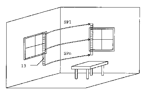
15 The parallel production of a plurality of traces of
distance-measuring points on the target object is shown in
Fig. 8 for a fourth example of surveying by the surveying
method according to the invention and a surveying device
according to the invention with fan-like scanning effect.
20 The surveying device used in this example corresponds to the
first embodiment shown in Fig. 2a with the optical element
in the beam path for the fan-like variation of the emission
direction.
By means of the optical element, no longer is
only one point and hence one axis of the rangefinder
coordinated with each orientation of the axis of the
radiation source. Now, a periodic variation of the emission
direction is produced so that, instead of only a single
field point, a strip 13 of field points is surveyed. As in
the method examples already explained, this strip is now
passed through the room segment to be determined or
surveyed. Thus, by a single manual movement from left to
right, a multiplicity of traces SPn is produced instead of
only a single trace SP1 as a sequence of field points, so
that a two-dimensional field of field points is generated.
In addition to the saving of time or manual effort, this
field permits in particular more uniform scanning since
there is a homogeneous distribution of the points within the
strip. If the scanning speed in the strip 13 is applied so
that the period for scanning the strip is small compared
CA 02589998 2013-03-13
21
with the time scale of the manual movement, a comparatively
densely and homogeneously scanned segment can be covered.