Note: Descriptions are shown in the official language in which they were submitted.
CA 02592996 2007-07-04
WO 2006/073739 PCT/US2005/045616
METHOD AND SYSTEM FOR GUIDING A VEHICLE WITH VISION-BASED
ADJUSTMENT
Field of the Invention
[0001] This invention relates to a method and system for guiding a vehicle
with
vision adjustment.
Background of the Invention
[0002] Global Positioning System (GPS) receivers have been used for providing
position data for vehicular guidance applications. However, although certain
GPS
receivers with differential correction may have a general positioning error of
approximately 10 centimeters (4 inches) during a majority of their operational
time,
an absolute positioning error of more than 50 centimeter (20 inches) is
typical for five
percent of their operational time. Further, GPS signals may be blocked by
buildings,
trees or other obstructions, which can make GPS-only navigation system
unreliable
in certain locations or environments. Accordingly, there is a need for
supplementing
or enhancing a GPS-based navigation system with one or more additional sensors
to
increase accuracy and robustness.
Summary of the Invention
[0003] A method and system for guiding a vehicle comprises a location module
(e.g., location-determining receiver) for collecting preliminary location data
for the
vehicle. A vision module collects vision-derived location data for the vehicle
during
an evaluation time window. A vision module estimates vision quality data for
the
corresponding collected vision-derived location data during the evaluation
time
window. A adjuster adjusts the preliminary location data to a revised location
data
based on the vision-derived location data such that the revised location data
is
registered with or generally coextensive with the vision-derived location
data, if the
vision quality data exceeds the minimum threshold level.
Brief Description of the Drawings
[0004] FIG. 1 is a block diagram of a system for guiding a vehicle based on
preliminary location data and vision-derived location data in accordance with
the
invention.
[0005] FIG. 2 is a flow chart of a method for guiding a vehicle based on
preliminary
CA 02592996 2007-07-04
WO 2006/073739 PCT/US2005/045616
location data and vision-derived location data in accordance with the
invention.
[0006] FIG. 3 is a flow chart of another method for guiding a vehicle based on
preliminary location data and vision-derived location data in accordance with
the
invention.
[0007] FIG. 4 is a chart that illustrates static positioning error of location
data, such
as a guidance signal derived from differential Global Positioning System
(GPS).
[0008] FIG. 5 is a chart that illustrates positioning error of location data,
such as a
guidance signal derived from differential Global Positioning System (GPS)
signal
after "tuning" by another sensor, such as a vision module in accordance with
the
invention.
Description of the Preferred Embodiment
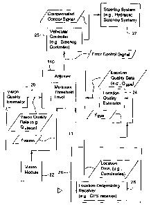
[0009] FIG. 1 is a block diagram of a guidance system 11 for guiding a
vehicle.
The guidance system 11 may be mounted on or collocated with a vehicle or
mobile
robot. The guidance system 11 comprises a vision module 22 and a location-
determining receiver 28 that communicates with an adjuster 110.
[0010] The vision module 22 may be associated with a vision quality estimator
20.
The location-determining receiver 28 may be associated with a location quality
estimator 24. The adjuster 110 may communicate with a vehicular controller 25.
In
turn, the vehicular controller 25 is coupled to a steering system 27.
[0011] The location-determining receiver 28 may comprise a Global Positioning
System (GPS) receiver with differential correction (e.g., a GPS receiver and a
receiver for receiving a differential correction signal transmitted by a
satellite or
terrestrial source). The location determining receiver 28 provides location
data (e.g.,
coordinates) of a vehicle. The location-determining receiver 28 may indicate
one or
more of the following conditions or status (e.g., via a status signal) to at
least the
adjuster 110 or the location quality estimator 24: (1) where the location-
determining
receiver 28 is disabled, (2) where location data is not available or corrupt
for one or
more corresponding evaluation intervals, and (3) where the estimated accuracy
or
reliability of the location data falls below a minimum threshold for one or
more
evaluation intervals. The location-determining receiver 28 provides location
data for
2
CA 02592996 2007-07-04
WO 2006/073739 PCT/US2005/045616
a vehicle that is well-suited for global navigation or global path planning.
[0012] In one illustrative embodiment, the location-determining receiver 28
outputs
location data in the following format:
0013 Ealf -~-t where Eoff s is the off-track error estimated b the location-
[ ] Y9PS- E + 9P y
hcad - gps
determining receiver 28 (e.g., location-determining receiver 28), and E,1ead
gPs is the
heading error estimated by the location-determining receiver 28.
[0014] The vision module 22 may comprise an image collection system and an
image processing system. The image collection system may comprise one or more
of the following: (1) one or more monocular imaging systems for collecting a
group of
images (e.g., multiple images of the same scene with different focus settings
or lens
adjustments, or multiple images for different field of views (FOV)); (2) a
stereo vision
system (e.g., two digital imaging units separated by a known distance and
orientation) for determining depth information or three-dimensional
coordinates
associated with points on an object in a scene; (3) a range finder (e.g.,
laser range
finder) for determining range measurements or three-dimensional coordinates of
points on an object in a scene; (4) a ladar system or laser radar system for
detecting
the speed, altitude, direction or range of an object in a scene; (5) a
scanning laser
system (e.g., a laser measurement system that transmits a pulse of light and
estimates distance between the laser measurement system and the object based
on
the time of propagation between transmission of the pulse and reception of
its.
reflection) for determining a distance to an object in a scene; and (6) an
imaging
system for collecting images via an optical micro-electromechanical system
(MEMS),
free-space optical MEMS, or an integrated optical MEMS. Free-space optical
MEMS
use compound semiconductors and materials with a range or refractive indexes
to
manipulate visible light, infra-red, or ultraviolet light, whereas integrated
optical
MEMS use polysilicon components to reflect, diffract, modulate or manipulate
visible
light, infra-red, or ultraviolet light. MEMS may be structured as switching
matrixes,
lens, mirrors and diffraction gratings that can be fabricated in accordance
with
various semiconductor fabrication techniques. The images collected by the
image
processing system may be in color, monochrome, black-and-white, or grey-scale
3
CA 02592996 2007-07-04
WO 2006/073739 PCT/US2005/045616
images, for example.
[0015] The vision module 22 or vision-derived location data may support the
collection of position data (in two or three dimensional coordinates)
corresponding to
the location of features of an object within the image. The vision module 22
is well
suited for using (a) features or local features of an environment around a
vehicle, (b)
position data or coordinates associated with such features, or both to
facilitate
navigation of the vehicle. The local features may comprise one or more of the
following: plant row location, fence location, building location, field-edge
location,
boundary location, boulder location, rock locations (e.g., greater than a
minimum
threshold size or volume), soil ridge and furrows, tree location, crop edge
location, a
cutting edge on vegetation (e.g., turf), and a reference marker. The vision-
derived
location data or position data of local features may be used to tune (e.g.,
correct for
drift) the preliminary location data from the location-determining receiver 28
on a
regular basis (e.g., periodically).
[0016] In one example, a reference marker may be associated with high
precision
location coordinates. Further, other local features may be related to the
reference
marker position. The current vehicle position may be related to the reference
marker position or the fixed location of local features or the location of the
vehicle. In
one embodiment, the vision module 22 may express the vision-derived location
data
on the vehicle location in coordinates or a data format that is similar to or
substantially equivalent to the coordinates or data format of the location-
determining
receiver 28.
[0017] The vision module 22 may indicate one or more of the following via a
status
or data message to at least the adjuster 110 or the vision quality estimator
20: (1)
whether the vision module 22 is disabled, (2) whether vision-derived location
data is
not available during one or more evaluation intervals, (3) whether the vision-
derived
location data is unstable or corrupt, and (4) whether the image data is
subject to an
accuracy level, a performance level or a reliability level that does not meet
a
threshold performance/reliability level.
[0018] In one example, a vision module 22 is able to identify plant row
location with
an error as small as 1 centimeter for soybeans and 2.4 centimeter for corn.
4
CA 02592996 2007-07-04
WO 2006/073739 PCT/US2005/045616
[0019] In one illustrative example, the vision module 22 outputs vision-
derived
location data in the following format:
Eoff _ vision
[0020] y,,;s;o~= , where Eoff ,,;S;oõ is the off track error estimated by the
Ehend vision
vision module 22 and Ehead ,,;S;oõ is the heading error estimated by the
vision module
22.
[0021] The location quality estimator 24 may comprise one or more of the
following
devices: a signal strength indicator associated with the location-determining
receiver
28, a bit error rate indicator associated with the location-determining
receiver 28,
another device for measuring signal quality, an error rate, signal strength,
or
performance of signals, channels, or codes transmitted for location-
determination.
Further, for satellite-based location-determination, the location quality
estimator 24
may comprise a device for determining whether a minimum number of satellite
signals (e.g., signals from four or more satellites on the L1 band for GPS) of
a
sufficient signal quality are received by the location-determining receiver 28
to
provide reliable location data for a vehicle during an evaluation interval.
[0022] The location quality estimator 24 estimates the quality of the
preliminary
location data or location quality data (e.g., Qgps) outputted by the location-
determining receiver 28. The location quality estimator 24 may estimate the
quality
of the preliminary location data based on the signal strength indicator (or
bit-error
rate) of each signal component received by the location-determining receiver
28.
The location quality estimator 24 may also base the quality estimate on any of
the
following factors: (1) the number of satellite signals that are available in
an area, (2)
the number of satellites that are acquired or received by the location-
determining
receiver with a sufficient signal quality (e.g., signal strength profile) and
(3) whether
each satellite signal has an acceptable signal level or an acceptable bit-
error rate
(BER) or frame-error rate (FER).
[0023] In one embodiment, different signal strength ranges are associated with
different corresponding quality levels. For example, the lowest signal
strength range
is associated with the low quality, a medium signal strength range is
associated with
a fair quality, and highest signal strength range is associated with a highest
quality.
CA 02592996 2007-07-04
WO 2006/073739 PCT/US2005/045616
Conversely, the lowest bit-error rate range is associated with the highest
quality, the
medium bit error range is associated with the fair quality, and the highest
bit error
rate range is associated with the lowest quality level.
[0024] The vision quality estimator 20 estimates the quality of the vision-
derived
location data or vision quality data (e.g., Q;;( õ) outputted by the vision
module 22.
The vision quality estimator 20 may consider the illumination present during a
series
of time intervals in which the vision module 22 operates and acquires
corresponding
images. The vision quality estimator 20 may include a photo-detector, a photo-
detector with a frequency selective lens, a group of photo-detectors with
corresponding frequency selective lenses, a charge-coupled device (CCD), a
photometer, cadmium-sulfide cell, or the like. Further, the vision quality
estimator 30
comprises a clock or timer for time-stamping image collection times and
corresponding illumination measurements (e.g., luminance values for images).
If the
illumination is within a low intensity range, the vision quality is low for
the time
interval; if the illumination is within a medium intensity range, the vision
quality is
high for the time interval; and if the illumination is within a high intensity
range, the
vision quality is fair, low or high for the time interval depending upon
defined sub-
ranges within the high intensity range. The foregoing intensity range versus
quality
may be applied on a light frequency by light frequency or light color basis,
in one
example. In another example, the intensity range versus quality may be applied
for
infra-red range frequencies and for ultraviolet range frequencies differently
than for
visible light.
[0025] The vision quality estimation may be related to a confidence measure in
processing the images. If the desired features (e.g., plant rows) are apparent
in one
or more images, the vision quality estimator 20 may assign a high image
quality or
high confidence level for the corresponding images. Conversely, if the desired
features are not apparent in one or more images (e.g., due to missing crop
rows),
the vision quality estimator 20 may assign a low image quality or a low
confidence
level. In one example, the confidence level is determined based on a sum of
the
absolute-differences (SAD) of the mean intensity of each column vector (e.g.,
velocity vector for the vision module 22) for the hypothesized yaw/pitch pair.
Yaw
6
CA 02592996 2007-07-04
WO 2006/073739 PCT/US2005/045616
may be defined as the orientation of the vision module 22 in an x-y plane and
pitch
may be defined as the orientation of the vision module 22 in the an x-z plane,
which
is generally perpendicular to the x-y plane.
[0026] If the vision module 22 is unable to locate or reference a reference
feature
or reference marker in an image or has not referenced a reference marker in an
image for a threshold maximum time, the vision module 22 may alert the vision
quality estimator 20, which may degrade the quality of the vision-derived
location
data by a quality degradation indicator.
[0027] In general, the adjuster 110 comprises a data processor, a
microcontroller,
a microprocessor, a digital signal processor, an embedded processor or any
other
programmable (e.g., field programmable) device programmed with software
instructions. In one embodiment, the adjuster 110 comprises a rule manager.
The
rule manager of the adjuster 110 may apply the preliminary location data, or a
derivative thereof, as the error control signal for a corresponding time
interval, unless
the vision quality data exceeds the minimum threshold level. No adjustment may
be
required unless the preliminary location data and the vision-derived location
data
differ by more than a maximum tolerance. The vision weight determines the
extent
that the contribution of the vision-derived location data (e.g., y;s;oõ) from
the vision
module 22 governs. The location weight determines the extent that the
contribution
of location data from the location module 22 governs. The mixer 14 determines
the
relative contributions of location data (e.g., y9As) and vision-derived
location data (
e.g., y;s;oõ) to the error control signal (e.g., y) based on the both the
vision weight
and the location weight. In one embodiment, the mixer 14 may comprise a
digital
filter, a digital signal processor, or another data processor arranged to
apply one or
more of the following: (1) the vision-derived location data weight, (2) the
location
data weight, and (3) a mixing ratio expression of the relative contributions
of the
location data and the vision-derived location data for an evaluation time
interval.
[0028] The error control signal represents a difference (or an error) between
measured location data (measured by the vision module 22 and by location
module)
and the actual location of the vehicle. Such an error control signal is
inputted to the
vehicle controller 25 to derive a compensated control signal. The compensated
7
CA 02592996 2007-07-04
WO 2006/073739 PCT/US2005/045616
control signal corrects the management and control of the steering system 27
based
on the error control signal. The steering system 27 may comprise an electrical
interface for communications with the vehicle controller 25. In one
embodiment, the
electrical interface comprises a solenoid-controlled hydraulic steering system
or
another electromechanical device for controlling hydraulic fluid.
[0029] In another embodiment, the steering system 27 comprises a steering
system
unit (SSU). The SSU may be associated with a heading versus time requirement
to
steer or direct the vehicle along a desired course or in conformance with a
desired
path plan. The heading is associated with a heading error (e.g., expressed as
the
difference between the actual heading angle an the desired heading angle).
[0030] The SSU may be controlled to compensate for errors in the estimated
position of the vehicle by the vision module 22 or the location-determining
receiver
28. For example, an off-track error indicates or is representative of the
actual
position of the vehicle (e.g., in GPS coordinates) versus the desired position
of the
vehicle (e.g., in GPS coordinates). The off-track error may be used to modify
the
movement of the vehicle with a compensated heading. However, if there is no
off-
track error at any point in time or a time interval, an uncompensated heading
may
suffice. The heading error is a difference between actual vehicle heading and
estimated vehicle heading by the vision module 22 and the location-determining
receiver 28.
[0031] FIG. 2 is a flow chart of a method for guiding a vehicle with a vision-
derived
location data and location data. The method of FIG. 2 begins in step S200.
[0032] In step S200, a location-determining receiver 28 or a location-
determining
receiver 28 determines preliminary location data for a vehicle associated
therewith.
For example, the location-determining receiver 28 (e.g., a GPS receiver with
differential correction) may be used to determine coordinates of the vehicle
for one
or more evaluation time intervals or corresponding times. Further, in step
S200, the
location-determining receiver 28 may determine or derive a location-error
signal
(e.g., ygps) from the location data. The location-error signal may represent a
(1)
difference between the actual vehicular location and a desired vehicular
location for
a desired time, (2) a difference between the actual vehicular heading and a
desired
8
CA 02592996 2007-07-04
WO 2006/073739 PCT/US2005/045616
vehicular heading for a desired time or position, (3) or another expression of
error
associated with the location data. The location-error signal may be defined,
but
need not be defined, as vector data.
[0033] In step S202, a vision module 22 associated with the vehicle determines
vision-derived location data for one or more of said evaluation time intervals
or
corresponding times. For example, the vision module 22 may collect images and
process the collected images to determine vision-derived location data. In one
example, the vision-derived location data comprises vision-derived position
data of a
vehicle, which is obtained by reference to one or more visual reference marker
or
features with corresponding known locations to determine coordinates of a
vehicle.
The coordinates of a vehicle may be determined in accordance with a global
coordinate system or a local coordinate system. Further, in step S202, the
location-
determining receiver 28 may determine or derive a vision error signal (e.g.,
yvision)
from the location data. The vision error signal represents (1) a difference
between
the actual vehicular location and a desired vehicular location for a desired
time, (2) a
difference between the actual vehicular heading and a desired vehicular
heading for
a desired time or position, (3) or another expression of error associated with
the
vision-derived location data.
[0034] In step S204, a vision quality estimator 20 estimates vision quality
data
during the evaluation time window. The vision quality estimator 20 may
comprise a
luminance or photo-detector and a time or clock for time-stamping luminance
measurements to determine a quality level based on the ambient lighting
conditions.
The vision quality estimator 20 may also comprise a measure of confidence or
reliability in processing the images to obtain desired features. The
confidence or
reliability in processing the images may depend upon any of the following
factors,
among others: technical specification (e.g., resolution) of the vision module
22,
reliability of recognizing an object (e.g., landmark in an image), reliability
of
estimating a location of the recognized object or a point thereon, reliability
of
converting image coordinates or local coordinates to a global coordinates or
vision-
derived location data that is spatially and temporally consistent with the
location data
from the location-determining receiver 28.
9
CA 02592996 2007-07-04
WO 2006/073739 PCT/US2005/045616
[0035] Step S204 may be carried out by various techniques which may be applied
alternately or cumulatively. Under a first technique, the vision quality
estimator 20
may estimate a confidence or reliability in the accuracy of vision-derived
location
data. Under a second technique, the vision quality estimator 20 first
estimates the
confidence level, reliability level or another quality level in the accuracy
of the vision-
derived location data; and , second, the vision quality estimator 20 converts
the
quality level into a corresponding linguistic value.
[0036] In step S206, a adjuster 110 adjusts the preliminary location data to a
revised location data based on the vision-derived location data such that the
revised
location data is registered with or generally coextensive with the vision-
derived
location data, if the vision quality data exceeds the minimum threshold level.
For
example, the adjuster 110 may adjust the preliminary location data for any
time slot
or evaluation time window, where the vision quality data exceeds a minimum
threshold level. Registered with or generally coextensive with means that the
vision-
derived location data and the preliminary location data for the same time
interval are
generally coextensive or differ by a maximum tolerance (e.g., which may be
expressed as a distance, a vector, or separation in seconds (or other units)
between
geographic coordinates). For example, the maximum tolerance may be set to be a
particular distance (e.g., 2.54 centimeters) within a range from one
centimeter to 10
centimeters.
[0037] In one embodiment, the adjuster 110 transmits or makes available an
error
control signal to the vehicular controller 25 based on the preliminary
location data or
revised location data. The revised location data, or the error control signal
derived
therefrom, may be updated on a time-slot-by-time-slot basis (e.g., during an
application time window). Each time slot may be commensurate in scope to the
evaluation time interval.
[0038] The adjuster 206 may enhance the reliability and accuracy of the
revised
location data or position information that is provided for navigation or
control of the
vehicle by using the vision-derived location data of verified quality as a
quality
benchmark against the preliminary location data. Although the preliminary
location
data and visional-derived quality data are collected during an evaluation time
CA 02592996 2007-07-04
WO 2006/073739 PCT/US2005/045616
window; the adjustment of step S206 to the revised location data may be
applied
during an application time window that lags the evaluation time window or that
is
substantially coextensive with the evaluation time interval. Regardless of how
the
evaluation time window and the application time window are defined in this
example,
in other examples the adjuster 110 may provide predictive control data, feed-
forward
control data, or feedback control data to the vehicle controller 25.
[0039] The method of FIG. 3 is similar to the method of FIG. 2, except the
method
of FIG. 3 includes additional step S205 and replaces step S206 with step S208.
Like
reference numbers indicate like procedures or steps.
[0040] In step S205, a location quality estimator 24 estimates location
quality data
for the location data during an evaluation time window. Step S205 may be
carried
out by various techniques which may be applied alternately or cumulatively.
Under a
first technique, the location quality estimator 24 may estimate or measure
signal
quality, an error rate (e.g., bit error rate or frame error rate), a signal
strength level
(e.g., in dBm), or other quality levels. Under a second technique, the
location quality
estimator 24 first estimates or measures signal quality, an error rate (e.g.,
bit error
rate or frame error rate), a signal strength level (e.g., in dBm), or other
quality levels;
second, the location quality estimator 24 classifies the signal quality data
into
ranges, linguistic descriptions, linguistic values, or otherwise.
[0041] In step S208, an adjuster 110 adjusts the preliminary location data to
a
revised location data based on the vision-derived location data such that the
revised
location data is registered with or generally coextensive with the vision-
derived
location data, if the vision quality data exceeds the minimum threshold level
and if
the location quality data is less than or equal to a triggering threshold
level. For
example, the adjuster 110 may adjust the preliminary location data for any
time slot
or evaluation time window, where the vision quality data exceeds a minimum
threshold level and where the location quality data is less than or equal to a
triggering threshold level. For example, he triggering threshold level may be
where
the reliability or accuracy of the preliminary location data is less than
desired
because of the lack of availability of satellites, or low received signal
quality (e.g., low
signal strength) of satellite signals or ancillary transmissions (e.g.,
terrestrial
11
CA 02592996 2007-07-04
WO 2006/073739 PCT/US2005/045616
references) used to determine precision preliminary location data. The
adjuster 206
may enhance the reliability and accuracy of the revised location data or
position
information that is provided for navigation or control of the vehicle by using
the
vision-derived location data of verified quality as a quality benchmark
against the
preliminary location data. The method of FIG. 3 makes the adjustment to the
revised
location data in a more selective manner than FIG. 2, by imposing the
additional
condition of location data quality falling below a standard (e.g., triggering
threshold
level).
[0042] FIG. 4 is a chart that illustrates static positioning error of location
data, such
as a differential GPS signal. The vertical axis shows error in distance (e.g.,
meters),
whereas the horizontal axis shows time (e.g. seconds).
[0043] FIG. 5 is a chart that illustrates dynamic positioning error of
location data,
such as a differential GPS signal (e.g., location data) after "tuning" at a
desired
update frequency or rate. The vertical axis shows error in distance (e.g.,
meters),
whereas the horizontal axis shows time (e.g. seconds). FIG. 5 shows the
original
error without "tuning" as solid circular points and error after "tuning" as
circles. The
tuning achieved by using the vision-derived location data to adjust the
location data
at regular intervals (e.g., at 5 second intervals or .2 Hz as illustrated in
FIG. 5).
[0044] Having described the preferred embodiment, it will become apparent that
various modifications can be made without departing from the scope of the
invention
as defined in the accompanying claims.
12