Note: Descriptions are shown in the official language in which they were submitted.
CA 02597057 2011-05-30
WO 2006/086253 PCT/US2006/003979
METHOD AND APPARATUS FOR ENHANCING A DIGITAL ELEVATION MODEL
(DEM) FOR TOPOGRAPHICAL MODELING
Background of the Invention
Topographical models of geographical areas may be
used for many applications, including flight simulators and
flood plain analysis. Furthermore, topographical models of
man-made structures (e.g., cities) may be extremely helpful in
applications such as cellular antenna placement, urban
planning, disaster preparedness and analysis, and mapping, for
example.
Various types and methods for making topographical
models are presently being used. One common topographical
model is the digital elevation model (DEM) . A DEM is a
sampled matrix representation of a geographical area which may
be generated in an automated fashion by a computer. In a DEM,
coordinate points are made to correspond with a height value.
DEMs are typically used for modeling terrain where the
transitions between different elevations (e.g., valleys,
mountains, etc.) are generally smooth from one to a next.
That is, DEMs typically model terrain as a plurality of curved
surfaces and any discontinuities therebetween are thus
"smoothed" over. For this reason, DEMs generally are not well
suited for modeling man-made structures, such as skyscrapers
in a downtown area, with sufficient accuracy for many of the
above applications.
U.S. Patent No. 6,654,690 to Rahmes et al. discloses
a significant advance in topography. The `690 patent
discloses an automated method for making a topographical model
of an area including terrain and buildings thereon based upon
randomly spaced data of elevation versus position. The `690
patent is assigned to the assignee of the present invention.
The method includes processing the randomly spaced data to
-1-
CA 02597057 2007-08-07
WO 2006/086253 PCT/US2006/003979
generate gridded data of elevation versus position conforming
to a predetermined position grid, processing the gridded data
to distinguish building data from terrain data, and performing
polygon extraction for the building data to make the
topographical model of the area including terrain and
buildings thereon.
In addition, the quality of the DEMs affect modeling
of the terrain, and modeling of the buildings and foliage on
the terrain. As mentioned above, the `690 patent discloses
that the initial DEM is separated into a terrain only DEM and
a building only DEM. While this helps to enhance the quality
of each respective DEM prior to modeling, there is still a
need to further improve enhancement of the respective DEMs so
that the displayed topographical model may be more realistic.
Summary of the Invention
In view of the foregoing background, it is therefore
an object of the present invention to further enhance a
digital elevation model (DEM) prior to modeling the buildings,
foliage and terrain within the DEM.
This and other objects, features, and advantages in
accordance with the present invention are provided by a
computer implemented method for processing an original digital
elevation model (DEM) including data for terrain and a
plurality of objects thereon. The method may comprise
generating a lower-resolution DEM from the original DEM,
generating an objects-only DEM based upon a comparison of the
lower-resolution DEM and the original DEM, and reducing noise
in the objects-only DEM.
Reducing noise in the objects-only DEM may comprise
identifying nulls in the objects-only DEM based upon a first
window size, expanding the nulls identified in the objects-
only DEM, and filling in the expanded nulls in the objects-
only DEM to generate a first refined objects-only DEM.
-2-
CA 02597057 2007-08-07
WO 2006/086253 PCT/US2006/003979
The method may further comprise identifying nulls in
the first refined objects-only DEM based upon the first window
size, expanding the nulls identified in the first refined
objects-only DEM, and filling in the expanded nulls in the
first refined objects-only DEM to generate a second refined
objects-only DEM.
A noise-only DEM may be generated based upon a
comparison between the first refined objects-only DEM and the
second refined objects-only DEM. The noise-only DEM may be
subtracted from the second refined objects-only DEM for
generating a final refined objects-only. The final refined
objects-only DEM may have significantly less noise than the
initial objects-only DEM that is typically used in the prior
art for topographical modeling. This advantageously results in
a more realistic topographical modeling.
Another embodiment for enhancing the objects-only
DEM is as follows. A lower-resolution DEM may be generated
from the original DEM, and nulls in the lower-resolution DEM
are identified based upon a first window size, and the nulls
are filled in. An objects-only DEM may then be generated
based upon a comparison of the lower-resolution DEM with the
filled in nulls and the original DEM. An original DEM without
the objects may be generated based upon a comparison between
the objects-only DEM and the original DEM. Nulls in the
original DEM without the objects are identified based upon the
first window size, and the nulls are expanded.
A lower-resolution DEM without the objects is
generated from the original DEM without the objects, and nulls
in the lower-resolution DEM without the objects are identified
based upon the first window size, and the nulls are filled in
for generating a terrain-only DEM. A refined objects-only DEM
may then be generated based upon a comparison of the terrain-
only DEM with the original DEM. The refined objects-only DEM
may have significantly less noise than the initial objects-
-3-
CA 02597057 2007-08-07
WO 2006/086253 PCT/US2006/003979
only DEM that is typically used in the prior art for
topographical modeling. Again, this advantageously results in
a more realistic topographical modeling.
A refined terrair.-only DEM may also be generated.
This comprises generating a refined DEM without the objects
based upon a comparison between the refined objects-only DEM
and the original DEM, generating a lower-resolution DEM
without the objects from the refined DEM without the objects,
and identifying nulls in the lower-resolution DEM without the
objects based upon the first window size. The nulls are then
filled in for generating the refined terrain-only DEM. In
addition, a final refined objects-only DEM may be generated
based upon a comparison of the refined terrain-only DEM with
the original DEM.
Another aspect in accordance with the present
invention is directed to a computer-readable medium having
stored thereon a data structure for processing a digital
elevation model (DEM) including data for terrain and a
plurality of objects thereon. A first embodiment of the
computer-readable medium may comprise a first data field
containing data for generating a lower-resolution DEM from the
original DEM, a second data field containing data for
generating an objects-only DEM based upon a comparison of the
lower-resolution DEM and the original DEM, and a third data
field containing data for reducing noise in the objects-only
DEM.
A second embodiment of the computer-readable medium
may comprise a first data field containing data for generating
a lower-resolution DEM from the original DEM, a second data
field containing data for identifying nulls in the lower-
resolution DEM based upon a first window size and filling in
the nulls, and a third data field containing data for
generating an objects-only DEM based upon a comparison of the
lower-resolution DEM with the filled-in nulls and the original
-4-
CA 02597057 2007-08-07
WO 2006/086253 PCT/US2006/003979
DEM. A fourth data field may contain data for generating an
original DEM without the objects based upon a comparison
between the objects-only DEM and the original DEM, and a fifth
data field may contain data for identifying nulls in the
original DEM without the objects based upon the first window
size, and expanding the nulls. A sixth data field may contain
data for generating a lower-resolution DEM without the objects
from the original DEM without the objects, and a seventh data
field may contain data for identifying nulls in the lower-
resolution DEM without the objects based upon the first window
size, and filling in the nulls for generating a terrain-only
DEM. An eighth data field may contain data for generating a
refined objects-only DEM based upon a comparison of the
terrain-only DEM with the original DEM.
Yet another aspect in accordance with the present
invention is directed to a computer system for topographical
modeling comprising a processor for processing an original
digital elevation model (DEM) including data for terrain and a
plurality of objects thereon. The processor may process the
first and second embodiments of the computer-readable mediums
as discussed above.
Brief Description of the Drawings
FIG. 1 is a schematic block diagram of collecting
topographical data, and generating a topographical model from
the collected topographical data in accordance with the
present invention.
FIG. 2 is a flow diagram for generating a
topographical model in accordance with the present invention.
FIGS. 3-5 are computer screen displays corresponding
to generating an original DEM in accordance with the present
invention.
-5-
CA 02597057 2007-08-07
WO 2006/086253 PCT/US2006/003979
FIGS. 6-7 are computer screen displays corresponding
to a re-sampling of the original DEM in accordance with the
present invention.
FIGS. 8-10 are computer screen displays
corresponding to a null fill process performed on the re-
sampled DEM in accordance with the present invention.
FIGS. 11-13 are computer screen displays
corresponding to DEM subtractions for generating an objects-
only DEM and a DEM without the objects in accordance with the
present invention.
FIGS. 14-15 are computer screen displays
corresponding to a null expand process performed on the DEM
without the objects as provided in FIG. 13.
FIGS. 16-17 are computer screen displays
corresponding to generation of a terrain-only DEM in
accordance with the present invention.
FIGS. 18-19 are computer screen displays
corresponding to DEM subtractions for generating an enhanced
objects-only DEM and an enhanced DEM without the objects in
accordance with the present invention.
FIGS. 20-22 are computer screen displays
corresponding to the generation of a final terrain-only DEM
and a further enhanced objects-only DEM in accordance with the
present invention.
FIG. 23 is a computer screen display corresponding
to the generation of a second further enhanced objects-only
DEM based upon a null fill/null expansion in accordance with
the present invention.
FIG. 24 is a computer screen display corresponding
to the generation of a noise-only DEM in accordance with the
present invention.
FIG. 25 is a computer screen display corresponding
to the generation of a final objects-only DEM in accordance
with the present invention.
-6-
CA 02597057 2007-08-07
WO 2006/086253 PCT/US2006/003979
FIG. 26 is a flow diagram for separating the final
objects-only DEM as provided in FIG. 25 into a building DEM
and a foliage DEM.
FIG. 27 is a computer screen display for setting the
parameters associated with separating the final objects-only
DEM into a building DEM and a'foliage DEM in accordance with
the present invention.
FIG. 28 is a pictorial representation of the steps
for separating the final objects-only DEM into a building DEM
and a foliage DEM in accordance with the present invention.
FIG. 29 is a computer screen display of a
topographical model generated in accordance with the present
invention.
Detailed Description of the Preferred Embodiments
The present invention will now be described more
fully hereinafter with reference to the accompanying drawings,
in which preferred embodiments of the invention are shown.
This invention may, however, be embodied in many different
forms and should not be construed as limited to the
embodiments set forth herein. Rather, these embodiments are
provided so that this disclosure will be thorough and
complete, and will fully convey the scope of the invention to
those skilled in the art. Like numbers refer to like elements
throughout.
A collector 50 for collecting topographical data and
a system 60 for generating a digital elevation model (DEM)
from the collected topographical data will now be explained
with reference to FIG. 1. The DEM is of an area that includes
terrain 52 and objects on the terrain, wherein the objects may
be buildings 54 and foliage 56. The foliage 56 primarily
includes trees, and consequently, foliage and trees will be
interchangeable. Modeling of the terrain 52, buildings 54 and
-7-
CA 02597057 2007-08-07
WO 2006/086253 PCT/US2006/003979
trees 56 is based upon randomly or arbitrarily spaced data of
elevation versus position on. the area.
The collector 50, such as a light detection and
ranging (LIDAR) collector, may be used for collecting the
randomly spaced data. The randomly spaced data may nominally
be a set of non-uniformly spaced measurements of position and
height. The LIDAR collector 50 may be carried by an airplane
70 over the area of interest, such as a city. The area may
also include relatively small features, such as roads 58, for
example, as compared to the buildings 54 and trees 56.
Those of skill in the art will appreciate that a
LIDAR source provides data including elevation versus position
information from a single image. Multiple optical images of
the area taken from different perspectives are generally
required to provide elevation versus position data, whereas
this same information may be obtained from a single LIDAR
image. Of course, the present invention may use elevation data
versus position data from sources such as optical (e.g.,
photography), electro-optical, and infrared sources, for
example, in addition to LIDAR collectors as will be
appreciated by those of skill in the art. The position
information provided by the LIDAR data may include latitude
and longitude information, for example, though other suitable
position indicators may also be used.
Once the randomly spaced data is collected, the data
may be stored on a storage medium 80, such as a magnetic or
optical disk, for example, for transfer to a computer 62. Of
course, other suitable methods for transferring data may also
be used, as readily appreciated by those skilled in the art.
The randomly spaced data is used by the computer 62 to
generate a DEM for viewing.
A display 64 is connected to the computer 62 for
viewing the DEM. Input devices such as a keyboard 66 and
mouse 68 are also connected to the computer 62. In accordance
-8-
CA 02597057 2007-08-07
WO 2006/086253 PCT/US2006/003979
with the present invention, the computer 62 includes a
processor 69 for 1) enhancing the DEM by creating a terrain-
only DEM and an objects-only DEM, and then removing noise from
the objects-only DEM, and 2) separating the objects-only DEM
into a building DEM and a foliage DEM.
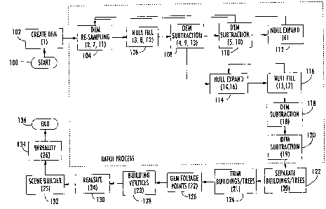
Generating and enhancing an original or initial DEM
will now be discussed with reference to the flow diagram of
FIG. 2, as well as to the computer display screens illustrated
in FIGS. 3-25. In the flow diagram, steps (1)-(19) will
initially be discussed, wherein steps (2)-(19) are considered
to be part of a batch process as will be discussed in greater
below. In the batch process, some of the blocks illustrated
in the flow diagram will be discussed more than once since
their respective functions are repeated based upon a looping
process. The number associated with each step being discussed
is provided in parenthesis within the corresponding block to
better illustrate the method for enhancing the original DEM.
From the start (Block 100), an initial step (1) is
using the computer 62 in Block 102 to generate an original DEM
from the randomly spaced data as provided via the storage
medium 80. Referring to the initial computer screen 200 as
illustrated in FIG. 3, the user selects the "Generate DEM From
Points" in field 202. This causes a "Points To DEM Settings"
computer screen 204 to be displayed, as illustrated in FIG. 4.
In the "Points To DEM Settings" computer screen 204,
the name of the file storing the collected data is entered in
field 206. The format of the points is selected in field 208.
In this case, the points are based upon a universal transverse
mercator (UTM) grid. The unit of measure of the points is
selected in field 210, which is in meters, for example. The
UTM grid includes 60 north-south zones, with each zone being 6
degrees wide in latitude. The UTM zone of interest is selected
in field 212. Zone 15 is selected in field 212, for example.
The resolution of the data is selected in field 214, and the
-9-
CA 02597057 2007-08-07
WO 2006/086253 PCT/US2006/003979
window filter size is selected in field 216, as readily
appreciated by those skilled in the art. The generated
original DEM is provided in the computer screen 300 as
illustrated in FIG. 5.
Steps (2)-(19) for enhancing the original DEM are
initiated by selecting the "Run Batch Process" in field 220
from the initial computer screen 200 as illustrated in FIG. 3.
As the batch process is run, fields 222, 224 and 226 allow the
user to set certain parameters associated with the batch
process. These parameters will be discussed below.
In Block 104, step (2) is the re-sampling of the
original DEM. The settings associated with the re-sampling
are provided in the computer screen 230 as illustrated in FIG.
6. The original DEM had a resolution of 1 meter, for example,
and will now be re-sampled at a lower resolution. The
resolution is set in field 232, which is 30 meters, for
example. The window filter size is also selected in field
234. The result is provided in the computer screen 302 as
illustrated in FIG. 7, which is a smoothing of the objects 54,
56 on the terrain 52.
In Block 106, a null fill is performed on the re-
sampled DEM. The null fill is associated with the null
manipulations provided in field 226 from the initial computer
screen 200 as illustrated in FIG. 3. The null manipulations
may be divided into a null expansion or a null fill as
provided in computer screen 240 in FIG. 8. Field 242
corresponds to the null expansion and field 244 corresponds to
the null filling. Since a null fill is being performed,
computer screen 250 is displayed as illustrated in FIG. 9.
The settings associated with the null fill include field 252
for the method of the fill, field 254 for the number of fill
passes to be performed, and field 256 for the fill reach. The
resulting re-sampled DEM after null filling is provided in
computer screen 304 as illustrated in FIG. 10.
-10-
CA 02597057 2007-08-07
WO 2006/086253 PCT/US2006/003979
In Block 108, a DEM subtraction is performed.
Computer screen 260 is associated with the DEM subtraction as
illustrated in FIG. 11. The threshold used in the DEM
subtraction is selected in field 262. The re-sampled DEM
after null filling in step (3) is subtracted from the original
DEM in step (1) to produce an objects-only DEM. The objects-
only DEM is provided in the computer screen 306 as illustrated
in FIG. 12.
In Block 110, step (5) is another DEM subtraction.
The objects-only DEM from step (4) is subtracted from the
original DEM in step (1) to produce a DEM without the objects.
This DEM is provided in the computer screen 308 as illustrated
in FIG. 13.
A null expansion is performed in Block 112 on the
DEM without the objects, which corresponds to step (6). The
computer screen 270 is associated with the null expansion as
illustrated in FIG. 14. The nulls are expanded corresponding
to the value selected in field 272. The null expansion makes
sure that all the objects have been removed so that the result
is a DEM without the objects at the 1 meter resolution, as
provided in the computer screen 310 and as illustrated in FIG.
15.
The run batch process now loops back to Block 104
for step (7). Block 104 performs a re-sampling on the DEM
without the objects as provided in FIG. 15. The re-sampling
is performed at a lower resolution, that is, from 1 meter to
meters. The result is provided in the computer screen 312
as illustrated in FIG. 16.
In Block 106, a second null fill is performed, which
30 corresponds to step (8). The second null fill is performed on
the re-sampled DEM without the objects as provided in Block
112. This process generates a terrain-only DEM as provided in
the computer screen 314 in FIG. 17. In Block 108, a second
DEM subtraction is performed, which corresponds to step (9).
-11-
CA 02597057 2007-08-07
WO 2006/086253 PCT/US2006/003979
The terrain-only DEM from step (8) is now subtracted from the
original DEM in step (1) to produce an enhanced objects-only
DEM. The enhanced objects-only DEM is provided in the
computer screen 316 as illustrated in FIG. 18. In Block 110,
step (10) is another DEM subtraction step. The enhanced
objects-only DEM from step ~9) is subtracted from the original
DEM in step (1) to produce an enhanced DEM without the
objects. The enhanced DEM without objects is provided in the
computer screen 318 as illustrated in FIG. 19.
For step (11), the run batch process again loops
back to Block 104. Block 104 performs another re-sampling on
the enhanced DEM without the objects as provided by Block 110.
As before, the re-sampling is also performed at a lower
resolution, that is, from 1 meter to 30 meters. The result is
provided in the computer screen 320 as illustrated in FIG. 20.
In Block 106, another null fill is performed, which
corresponds to step (12). This third null fill is performed
on the re-sampled DEM without the objects as provided by Block
104 to generate an enhanced terrain-only DEM as provided in
the computer screen 322 in FIG. 21. This DEM is also referred
to as the final terrain-only DEM.
In Block 108, a third DEM subtraction is performed,
which corresponds to step (13). The enhanced terrain-only DEM
from step (12) is subtracted from the original DEM in step (1)
to produce an even further enhanced objects-only DEM. The
further enhanced objects-only DEM is provided in the computer
screen 324 as illustrated in FIG. 22.
A null expansion is performed on the further
enhanced objects-only DEM in Block 114, which corresponds to
step (14). In Block 116, a null fill is performed, which
corresponds to step (15). Steps (14) and (15) are performed
to remove noise from around the objects to generate an even
further enhanced objects-only DEM. The process loops back to
Block 114 so that steps (16) and (17) are performed. That is,
-12-
CA 02597057 2007-08-07
WO 2006/086253 PCT/US2006/003979
another null expansion and null fill are performed to generate
a second further enhanced objects-only DEM as provided in the
computer screen 326 in FIG. 23.
In Block 118, a DEM subtraction is performed. The
second further enhanced objects-only DEM from step (17) is
subtracted from the further enhanced objects-only DEM from
step (15) to produce a noise-only DEM. The noise-only DEM is
provided in the computer screen 328 as illustrated in FIG. 24.
In Block 120, another DEM subtraction (step 19) is
performed. The noise-only PEM from step (18) is subtracted
from the second further enhanced objects-only DEM from step
(15) to produce a final objects-only DEM. The final objects-
only DEM is provided in the computer screen 330 as illustrated
in FIG. 25.
As discussed above for steps (2)-(19), a final
terrain-only DEM and a final objects-only DEM have been
generated. Compared to prior art DEMs, these DEMs are
enhanced as a result of the looping iterations performed in
steps (2)-(19). Yet another aspect in accordance with the
present invention that will now be discussed is the separation
of the final objects-only DEM into a building DEM and a
foliage DEM. In other words, the final objects-only DEM is
separated into two separate DEMs so that each DEM may be
separately processed.
Separating the final objects-only DEM into a
building DEM and a foliage DEM will now be discussed with
reference to the flow diagram illustrated in FIG. 26, as well
as to FIGS. 27-28. Referring to the computer screen 200
initially illustrated in FIG. 3, the user selects "Separate
Buildings and Trees" in field 227. This causes a "Separate
Buildings and Trees" computer screen 410 to be displayed, as
illustrated in FIG. 27.
Still referring to FIG. 27, the user has the option
of selecting several threshold parameters. Since the
-13-
CA 02597057 2007-08-07
WO 2006/086253 PCT/US2006/003979
separation is performed based upon calculating a perimeter per
area for each object, as well as the height of each object,
corresponding comparison threshold values are set via the
computer screen 410. For instance, the perimeter per area
threshold is set in field 412. The minimum size of each
object to be considered is set in field 414. This field is
labeled as the minimum posts. The chord residue is selected
in field 416, and corresponds to a width or length of a side
of the object being considered. A maximum tree height is
selected in field 418. A second threshold to be associated
with a second perimeter per area test is selected in field
420. This second threshold selected in field 420 may be
different than the first threshold selected in field 412.
To start separating (Block 500) the final objects-
only DEM into a building DEM and a foliage DEM, a perimeter
versus area parameter for each object in the final objects-
only DEM is determined in Block 502. For purposes of
explaining the present invention, reference will also be made
to FIG. 28, which provides a pictorial representation of how
the final objects-only DEM is separated into a building DEM
and a foliage DEM. For instance, a simplified representation
representing the final objects-only DEM as initially
illustrated in FIG. 25 is provided in frame 600 in FIG. 28.
As illustrated in frame 600, the objects include
buildings 54 and trees 56 grouped together in the same DEM.
The perimeter versus area parameter for each object is
compared to the selected threshold in Block 504 to identify
whether each object in the DEM is a building 54 or foliage 56.
Based upon the comparison to the threshold, the objects are
separated into a building DEM and a foliage DEM, as
illustrated in frames 602 and 604.
The data for each object includes a height value,
and the height value for each object identified as foliage 56
in frame 604 is compared to a height threshold in Block 506.
-14-
CA 02597057 2007-08-07
WO 2006/086253 PCT/US2006/003979
In Block 508, each foliage 56 in frame 604 is re-identified as
a building 54 if the height value associated therewith is
greater than the height threshold. As illustrated in frames
606 and 608, the building 54 initially identified as foliage
56 in frame 604 has been re-identified as a building in frame
606. However, tall trees 56 in frame 604 have now been
identified as buildings based upon the comparison to the
height threshold, as shown in frame 606.
In Block 510, a second perimeter versus area
parameter is determined for each object identified as a
building in frame 606. Each second perimeter versus area
parameter is compared to a second threshold in Block 512.
Each building 54 is re-identified as foliage 56 if the second
perimeter versus area parameter is greater than the second
threshold in Block 514.
The objects identified as buildings 54 are separated
into a building DEM, and the objects identified as foliage are
separated into a foliage DED" in Block 516. Separate building
and foliage DEMs advantageously allow more realistic
topographical models to be generated with significantly less
user intervention. The building DEM is represented by frame
610, and the foliage DEM is represented by frame 612. The
method for separating the final objects-only DEM into a
building DEM and a foliage DEM ends at Block 518. The above
steps for separating the final objects-only DEM into two
separate DEMs correspond to step (20) in FIG. 2.
The remaining steps (21)-(26) will now be discussed.
The buildings 54 and the trees 56 will each be modeled
differently. Block 124 corresponds to step (21) and is
optional, but allows the user to manually clean up or edit the
separation of the buildings 54 and trees 56 in case the
automatic process failed to correctly identify each object
correctly.
-15-
CA 02597057 2007-08-07
WO 2006/086253 PCT/US2006/003979
In Block 126, which corresponds to step (22), each
foliage in the foliage DEM 612 is modeled as 3D points. The
user selects the "Generate Points From DEM" in field 228 as
shown in FIG. 3 to convert the points into a list of x
(latitude), y (longitude) and z (height).
In Block 128, which corresponds to step (23), the
buildings are modeled as vectors. Modeling buildings as
vectors is disclosed in U.S. Patent No. 6,654,690 as discussed
in the background section. Texture is placed on the polygons
representing the buildings in Block 130, which corresponds to
step (24). In other words, images are placed on the polygons
to give the topographical model a realistic look. RealSiteTM
is one such commercially available tool to perform this task.
RealSiteTM was developed by the Harris Corporation, which is
assignee of the present invention.
In Block 132, SceneBuilderTM is used to format all
of the generated geometry and textures for display on the
computer system 60. SceneBuilderTM is a._so a commercially
available tool. Using InRealityTM in Block 134, the final
topographical model for display is provided, as illustrated in
FIG. 29. InRealityTM is another commercially available tool
developed by the Harris Corporation, and allows the user to
navigate virtual scenes and conduct various analyses.
InRealityTM is designed to be a companion to the RealSiteTM
software. The process ends at Block 136.
-16-