Note: Descriptions are shown in the official language in which they were submitted.
CA 02597661 2007-08-13
WO 2006/091487 PCT/US2006/005662
WELL PLACEMENT BY USE OF DIFFERENCES IN ELECTRICAL
ANISOTROPY OF DIFFERENT LAYERS
Tor Eiane & Wallace H. Meyer
BACKGROUND OF THE INVENTION
1. Field of the Invention
[0001] This invention relates generally to drilling of lateral wells into
earth
formations, and more particularly to the maintaining the wells in a desired
position
relative to an interface within a reservoir in situations where the earth
formations are
anisotropic..
2. Description of the Related Art
[0002] To obtain hydrocarbons such as oil and gas, well boreholes are drilled
by
rotating a drill bit attached at a drill string end. The drill string may be a
jointed
rotatable pipe or a coiled tube. Boreholes may be drilled vertically, but
directional
drilling systems are often used for drilling boreholes deviated from vertical
and/or
horizontal boreholes to increase the hydrocarbon production. Modem directional
drilling systems generally employ a drill string having a bottomhole assembly
(BHA)
and a drill bit at an end thereof that is rotated by a drill motor (mud motor)
and/or the
drill string. A number of downhole devices placed in close proximity to the
drill bit
measure certain downhole operating parameters associated with the drill
string. Such
devices typically include sensors for measuring downhole temperature and
pressure,
tool azimuth, tool inclination. Also used are measuring devices such as a
resistivity-
measuring device to determine the presence of hydrocarbons and water.
Additional
downhole instruments, known as measurement-while-drilling (MWD) or logging-
while-drilling (LWD) tools, are frequently attached to the drill string to
determine
formation geology and formation fluid conditions during the drilling
operations.
[0003] Boreholes are usually drilled along predetermined paths and proceed
through
various formations. A drilling operator typically controls the surface-
controlled
1
CA 02597661 2007-08-13
WO 2006/091487 PCT/US2006/005662
drilling parameters during drilling operations. These parameters include
weight on
bit, drilling fluid flow through the drill pipe, drill string rotational speed
(r.p.m. of the
surface motor coupled to the drill pipe) and the density and viscosity of the
drilling
fluid. The downhole operating conditions continually change and the operator
must
react to such changes and adjust the surface-controlled parameters to properly
control
the drilling operations. For drilling a borehole in a virgin region, the
operator
typically relies on seismic survey plots, which provide a macro picture of the
subsurface formations and a pre-planned borehole path. For drilling multiple
boreholes in the same formation, the operator may also have information about
the
previously drilled boreholes in the same formation.
[0004] In development of reservoirs, it is common to drill boreholes at a
specified
distance from fluid contacts within the reservoir. An example of this is shown
in Fig.
2 where a porous formation denoted by 105a, 105b has an oil water contact
denoted
by 113. The porous formation is typically capped by a caprock such as 103 that
is
impermeable and may further have a non-porous interval denoted by 109
underneath.
The oil-water contact is denoted by 113 with oil above the contact and water
below
the contact: this relative positioning occurs due to the fact the oil has a
lower density
than water. In reality, there may not be a sharp demarcation defining the oil-
water
contact; instead, there may be a transition zone with a change from high oil
saturation
at the top to a high water saturation at the bottom. In other situations, it
may be
desirable to maintain a desired spacing from a gas-oil. This is depicted by
114 in Fig.
1. It should also be noted that a boundary such as 114 could, in other
situations, be a
gas-water contact.
[0005] In order to maximize the amount of recovered oil from such a borehole,
the
boreholes are commonly drilled in a substantially horizontal orientation in
close
proximity to the oil water contact, but still within the oil zone. US Patent
RE35386 to
Wu et al, having the same assignee as the present application and the contents
of
which are fully incorporated herein by reference, teaches a method for
detecting and
2
CA 02597661 2007-08-13
WO 2006/091487 PCT/US2006/005662
sensing boundaries in a formation during directional drilling so that the
drilling
operation can be adjusted to maintain the drillstring within a selected
stratum is
presented. Wu shows examples of reservoir navigation using a multiple
propagation
resistivity tool. In such a tool, measurements are made at a pair of spaced
apart
receivers for signals resulting from excitation of transmitters symmetrically
disposed
about the two receivers. Resistivity values are determined from amplitude
differences
(Ra) and from phase difference (RP) of the signals at the two receives. The
method
used by Wu comprises the initial drilling of an offset well from which
resistivity of
the formation with depth is determined. This resistivity information is then
modeled
to provide a modeled log indicative of the response of a resistivity tool
within a
selected stratum in a substantially horizontal direction. A directional (e.g.,
horizontal)
well is thereafter drilled wherein resistivity is logged in real time and
compared to that
of the modeled horizontal resistivity to determine the location of the drill
string and
thereby the borehole in the substantially horizontal stratum. From this, the
direction of
drilling can be corrected or adjusted so that the borehole is maintained
within the
desired stratum. The resistivity sensor typically comprises at least one
transmitter and
at least one receiver. Measurements may be made with propagation sensors that
operate in the 400 kHz and higher frequency.
[0006] A limitation of the method and apparatus used by Wu is that resistivity
sensors
are responsive to oil/water contacts for relatively small distances, typically
no more
than 5 m; at larger distances, conventional propagation tools are not
responsive to the
resistivity contrast between water and oil. One solution that can be used in
such a
case is to use an induction logging tool that typically operate in frequencies
between
10kHz and 50kHz. US Patent 6,308,136 to Tabarovsky et al having the same
assignee
as the present application and the contents of which are fully incorporated
herein by
reference, teaches a method of interpretation of induction logs in near
horizontal
boreholes and determining distances to boundaries in proximity to the
borehole.
[0007] An alternative approach to determination of distances to bed boundaries
is
3
CA 02597661 2007-08-13
WO 2006/091487 PCT/US2006/005662
disclosed in US Patent Application Ser. No. 10/373,365 of Merchant et al.
Taught
therein is the use of multicomponent induction logging tools and measurements
as an
indicator of a distance to a bed boundary and altering the drilling direction
based on
such measurements. In conventional induction logging tools, the transmitter
and
receiver antenna coils have axes substantially parallel to the tool axis (and
the
borehole). The antenna configuration of the multicomponent tool of Merchant et
al.
is illustrated in Fig. 3.
[0008] Fig. 3 (prior art) shows the configuration of transmitter and receiver
coils in
the 3DExplorerTM (3DEX) induction logging instrument of Baker Hughes. Three
orthogonal transmitters 201, 203, and 205 that are referred to as the TX, TZ,
and Ty
transmitters are placed in the order shown. The three transmitters induce
magnetic
fields in three spatial directions. The subscripts (x, y, z) indicate an
orthogonal
system substantially defined by the directions of the normal to the coils of
the
transmitters. The z-axis is chosen to be along the longitudinal axis of the
tool, while
the x-axis and y-axis are mutually perpendicular directions lying in the plane
transverse to the axis. Corresponding to each transmitter 201, 203, and 205
are
associated receivers 211, 213, and 215, referred to as the RX, R,, and Ry
receivers,
aligned along the orthogonal system defined by the transmitter normals, placed
in the
order shown in Figure 1. RX, RZ, and Ry are responsible for measuring the
corresponding magnetic fields HXX, H, and H. Within this system for naming the
magnetic fields, the first index indicates the direction of the transmitter
and the second
index indicates the direction of the receiver. In addition, the receivers RY
and R,,
measure two cross-components, H,,Y and HXZ, of the magnetic field produced by
the TX
transmitter (201). This embodiment of the invention is operable in single
frequency
or multiple frequency modes. It should further be noted that the description
herein
with the orthogonal coils and one of the axes parallel to the tool axis is for
illustrative
purposes only. Additional components could be measured, and, in particular,
the coils
could be inclined at an angle other than 00 or 900 to the tool axis, and
furthermore,
need not be orthogonal; as long as the measurements can be "rotated" or
"projected"
4
CA 02597661 2007-08-13
WO 2006/091487 PCT/US2006/005662
onto three orthogonal axes, the methodology described herein is applicable. .
Measurements may also be made at a plurality of frequencies, and/or at a
plurality of
transmitter-receiver distances.
[0009] While the teachings of Merchant are show that the 3DEXTM measurements
are
very useful in determination of distances to bed boundaries (and in reservoir
navigation), Mercl2ant discusses the reservoir navigation problem in terms of
measurements made with the borehole in a substantially horizontal
configuration
(parallel to the bed boundary). This may not always be the case in field
applications
where the borehole is approaching the bed boundary at an angle. In a situation
where
the borehole is inclined, then the multicomponent measurements, particularly
the
cross-component measurements, are responsive to both the distance to the bed
boundary and to the anisotropy in the formation.
[0010] It would be desirable to have a method of determination of distance to
a bed
boundary in a deviated well in anisotropic earth formations. The present
invention
satisfies this need.
SUMMARY OF THE INVENTION
[0011] One embodiment of the present invention is a method of evaluating an
anisotropic earth formation having an interface. A principal cross-component
measurement is made with or derived from at least one receiver on an
instrument
conveyed in a borehole in the earth formation corresponding to excitation by
at least
one transmitter. A distance to an interface in the earth formation is
determined from
the principal cross-component measurement. The measurements may be made by
excitation of at least two transmitters symmetrically disposed about the at
least one
receiver. The interface may be a bed boundary or it may be a fluid contact.
The
principal cross components may be zx measurements. The resistivity measuring
instrument may be an induction instrument. The principal cross component
measurements may be direct measurements or measurements obtained by coordinate
5
CA 02597661 2007-08-13
WO 2006/091487 PCT/US2006/005662
rotation. Two receivers may be used, in which case a weighted difference of
measurements made by the two receivers may be used. Estimating the distance
may
be based on using a difference between at least one of (i) an in-phase
component of
the principal cross components, and, (ii) a quadrature component of the
principal
cross components. Using the method of the present invention, it is possible to
get
warning of approach to an interface where there is no contrast in horizontal
resistivity
but there is a contrast in vertical resistivity.
[0012] The instrument may be conveyed downhole on a wireline or be part of a
bottomhole assembly (BHA). In the latter case, the determined distance may be
used
in controlling the drilling direction and in reservoir navigation to maintain
a desired
distance of the BHA from the interface.
[0013] Another embodiment of the present invention is an apparatus for
evaluating an
anisotropic earth formation having an interface. Measurements are made by
exciting
pair of transmitters positioned on opposite sides of at least one receiver on
an
instrument conveyed in a borehole in the earth formation. The measurements may
be
principal component measurements or they may be rotated to give principal
component measurements. A processor determines from the principal component
measurements a distance to an interface in the earth formation. The interface
may be
a bed boundary or it may be a fluid contact. The principal cross components
may be
zx measurements. The resistivity measuring instrument may be an induction
instrument. Two receivers may be used, in which case a weighted difference of
measurements made by the two receivers may be used. The processor may estimate
the distance using a difference between at least one of (i) an in-phase
component of
the principal cross components, and, (ii) a quadrature component of the
principal
cross components. Measurements made with at least one of an x, y, z
transmitter and
at least one of an x, y, z receiver are to be considered as principal
components. A
cross-component has a y or z receiver (or by reciprocity, a y or z
transmitter).
6
CA 02597661 2007-08-13
WO 2006/091487 PCT/US2006/005662
[0014] The instrument may be conveyed downhole on a wireline or be part of a
bottomhole assembly (BHA). In the latter case, the determined distance may be
used
by a downhole processor for controlling the drilling direction and in
reservoir
navigation to maintain a desired distance of the BHA from the interface.
[0015] Another embodiment of the invention is a machine readable medium that
includes instructions for a method of evaluating an anisotropic earth
formation having
an interface. Based on the instructions, measurements made with at least one
receiver
on an instrument conveyed in a borehole in the earth formation corresponding
to
excitation from opposite sides of the receiver are processed to determine a
distance to
an interface in the earth formation. The interface may be a bed boundary or it
may be
a fluid contact. The principal cross components may be zx measurements. The
resistivity measuring instrument may be an induction instrument. The principal
cross
component measurements may be direct measurements or measurements obtained by
coordinate rotation. Two receivers may be used, in which case the instructions
provide for determination of a weighted difference of measurements made by the
two
receivers.. Estimating the distance may be based on using a difference between
at
least one of (i) an in-phase component of the principal cross components, and,
(ii) a
quadrature component of the principal cross components. The instrument may be
conveyed downhole on a wireline or be part of a bottomhole assembly (BHA). In
the
latter case, the instructions may enable use of the determined distance for
controlling
the drilling direction and/or maintaining a desired distance of the BHA from
the
interface. The machine readable medium may include ROMs, EPROMs, EEPROMs,
Flash Memories and Optical disks.
BRIEF DESCRIPTION OF THE DRAWINGS
[0016] For detailed understanding of the present invention, reference should
be made
to the following detailed description of the preferred embodiment, taken is
conjunction with the accompanying drawings, in which like elements have been
given
like numerals and wherein:
7
CA 02597661 2007-08-13
WO 2006/091487 PCT/US2006/005662
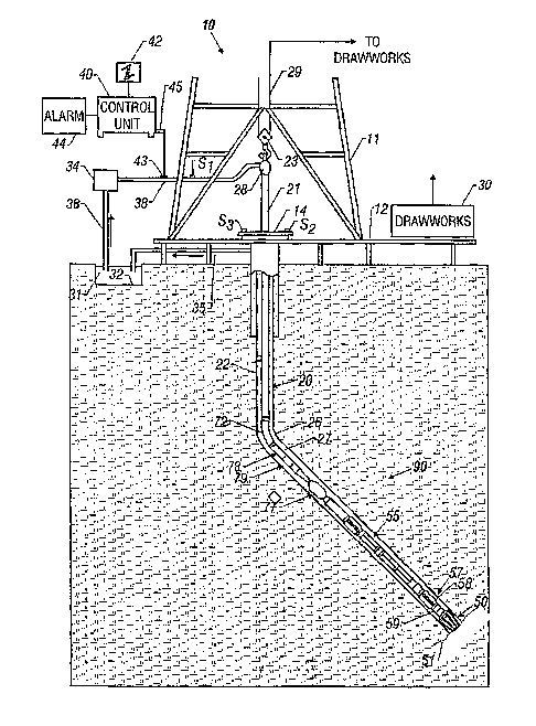
Figure 1 (prior art) shows a schematic diagram of a drilling system having a
drill
string that includes a sensor system according to the present invention;
Figure 2 is an illustration of a substantially horizontal borehole proximate
to an
oil/water contact in a reservoir,
Figure 3 (prior art) illustrates the 3DEXTM multi-component induction tool of
Baker
Hughes Incorporated;
Figure 4 illustrates the transmitter and receiver configuration of the
AZIVIRES tool
suitable for use with the method of the present invention;
Figures 5a, 5b show exemplary responses to a model in which a layer of
resistivity 2
92-m is positioned between two layers of resistivity 20 52-m.,
Figures 5c, 5d show the in-phase and quadrature component response for two
transmitters positioned on opposite sides of a receiver;
Figures 6a, 6b show the effect of anisotropy on a single transmitter response
in a
horizontal borehole;
Figures 7a, 7b show the effect of anisotropy on a single transmitter response
in a
deviated borehole;
Figures 7c, 7d show the effect of anisotropy on the response of a single
transmitter
positioned on the opposite side of the transmitter of figures 7a, 7b in a
deviated
borehole;
Figures 8a, 8b, 8c 8d show the dual transmitter response in a deviated
borehole for a
number of different anisotropy factors;
Figures 9a, 9b, 9c 9d show the dual transmitter responses in a deviated
borehole for
a fixed anisotropy factor and a number of different resistivities;
Fig. 10 shows prior art log measurements in a near horizontal well as it
crosses into a
marl layer;
Fig. 11 shows modeling results for the depth interval corresponding t Fig. 10,
and
Fig. 12 shows the ability of the method of the present invention to detect
proximity to
the marl layer as well as its direction.
DETAILED DESCRIPTION OF THE INVENTION
8
CA 02597661 2007-08-13
WO 2006/091487 PCT/US2006/005662
[0018J Fig. 1 shows a schematic diagram of a drilling system 10 with a
drillstring 20
carrying a drilling assembly 90 (also referred to as the bottom hole assembly,
or
"BHA") conveyed in a"wellbore" or "borehole" 26 for drilling the wellbore. The
drilling system 10 includes a conventional derrick 11 erected on a floor 12
which
supports a rotary table 14 that is rotated by a prime mover such as an
electric motor
(not shown) at a desired rotational speed. The drillstring 20 includes a
tubing such as
a drill pipe 22 or a coiled-tubing extending downward from the surface into
the
borehole 26. The drillstring 20 is pushed into the wellbore 26 when a drill
pipe 22 is
used as the tubing. For coiled-tubing applications, a tubing injector, such as
an
injector (not shown), however, is used to move the tubing from a source
thereof, such
as a reel (not shown), to the wellbore 26. The drill bit 50 attached to the
end of the
drillstring breaks up the geological formations when it is rotated to drill
the borehole
26. If a drill pipe 22 is used, the drillstring 20 is coupled to a drawworks
30.via a
Kelly joint 21, swivel 28, and line 29 through a pulley 23. During drilling
operations,
the drawworks 30 is operated to control the weight on bit, which is an
important
parameter that affects the rate of penetration. The operation of the drawworks
is well
known in the art and is thus not described in detail herein.
[0019] During drilling operations, a suitable drilling fluid 31 from a mud pit
(source)
32 is circulated under pressure through a channel in the drillstring 20 by a
mud pump
34. The drilling fluid passes from the mud pump 34 into the drillstring 20 via
a
desurger (not shown), fluid line 38 and Kelly joint 21. The drilling fluid 31
is
discharged at the borehole bottom 51 through an opening in the drill bit 50.
The
drilling fluid 31 circulates uphole through the annular space 27 between the
drillstring
20 and the borehole 26 and returns to the mud pit 32 via a return line 35. The
drilling
fluid acts to lubricate the drill bit 50 and to carry borehole cutting or
chips away from
the drill bit 50. A sensor Sl typically placed in the line 38 provides
information about
the fluid flow rate. A surface torque sensor S2 and a sensor S3 associated
with the
drillstring 20 respectively provide information about the torque and
rotational speed
of the drillstring. Additionally, a sensor (not shown) associated with line 29
is used to
9
CA 02597661 2007-08-13
WO 2006/091487 PCT/US2006/005662
provide the hook load of the drillstring 20.
[0020] In one embodiment of the invention, the drill bit 50 is rotated by only
rotating
the drill pipe 22. In another embodiment of the invention, a downhole motor 55
(mud
motor) is disposed in the drilling assembly 90 to rotate the drill bit 50 and
the drill
pipe 22 is rotated usually to supplement the rotational power, if required,
and to effect
changes in the drilling direction.
[0021] In an exemplary embodiment of Fig. 1, the mud motor 55 is coupled to
the
drill bit 50 via a drive shaft (not shown) disposed in a bearing assembly 57.
The mud
motor rotates the drill bit 50 when the drilling fluid 31 passes through the
mud motor
55 under pressure. The bearing assembly 57 supports the radial and axial
forces of
the drill bit. A stabilizer 58 coupled to the bearing assembly 57 acts as a
centralizer
for the lowermost portion of the mud motor assembly.
[0022] In one embodiment of the invention, a drilling sensor module 59 is
placed near
the drill bit 50. The drilling sensor module contains sensors, circuitry and
processing
software and algorithms relating to the dynamic drilling parameters. Such
paranieters
typically include bit bounce, stick-slip of the drilling assembly, backward
rotation,
torque, shocks, borehole and annulus pressure, acceleration measurements and
other
measurements of the drill bit condition. A suitable telemetry or communication
sub
72 using, for exaniple, two-way telemetry, is also provided as illustrated in
the drilling
assembly 90. The drilling sensor module processes the sensor information and
transmits it to the surface control unit 40 via the telemetry system 72.
[0023] The communication sub 72, a power unit 78 and an MWD too179 are all
connected in tandem with the drillstring 20. Flex subs, for example, are used
in
connecting the MWD too179 in the drilling assembly 90. Such subs and tools
form
the bottom hole drilling assembly 90 between the drillstring 20 and the drill
bit 50.
The drilling assembly 90 makes various measurements including the pulsed
nuclear
CA 02597661 2007-08-13
WO 2006/091487 PCT/US2006/005662
magnetic resonance measurements while the borehole 26 is being drilled. The
communication sub 72 obtains the signals and measurements and transfers the
signals,
using two-way telemetry, for example, to be processed on the surface.
Alternatively,
the signals can be processed using a downhole processor in the drilling
assembly 90.
[0024] The surface control unit or processor 40 also receives signals from
other
downhole sensors and devices and signals from sensors S1-S3 and other sensors
used
in the system 10 and processes such signals according to programmed
instructions
provided to the surface control unit 40. The surface control unit 40 displays
desired
drilling parameters and other information on a display/monitor 42 utilized by
an
operator to control the drilling operations. The surface control unit 40
typically
includes a computer or a microprocessor-based processing system, memory for
storing programs or models and data, a recorder for recording data, and other
peripherals. The control unit 40 is typically adapted to activate alarms 44
when
certain unsafe or undesirable operating conditions occur.
[0025] Fig.4 shows an azimuthal resistivity tool configuration suitable for
use with
the method of the present invention. This is a modification of the basic 3DEX
tool of
Fig. 3 and comprises two transmitters 251, 251' whose dipole moments are
parallel to
the tool axis direction and two receivers 253, 253' that are perpendicular to
the
transmitter direction. In one embodiment of the invention, the tool operates
at 400
kHz frequency. When the first transmitter fires, the two receivers measure the
magnetic field produced by the induced current in the formation. This is
repeated for
the second transmitter. The signals are combined in following way:
HTl = H2 -(dl l(d1 + d2)3 = Hl
HT2 = Hl - (dl /(dl + d2))3 . H2 (1).
Here, H1 and H2 are the measurements from the first and second receivers,
respectively, corresponding to excitation of a transmitter and the distances
dl and d2
are as indicated in Fig. 4. The tool rotates with the BHA and in an exemplary
mode
of operation, makes measurements at 16 angular orientations 22.5 apart. The
11
CA 02597661 2007-08-13
WO 2006/091487 PCT/US2006/005662
measurement point is at the center of two receivers. In a uniform, isotropic
formation,
no signal would be detected at either of the two receivers. The invention thus
makes
use of cross component measurements, called principal cross-components,
obtained
from a pair of transmitters disposed on either side of at least one receiver.
It should
further be noted that using well known rotation of coordinates, the method of
the
present invention also works with various combinations of measurements as long
as
they (i) correspond to signals generated from opposite sides of a receiver,
and, (ii) can
be rotated to give the principal cross components.
[0026] The dual transmitter configuration was originally developed to reduce
electronic errors in the instrument and to increase the signal to noise ratio.
See US
Patent 6,586,939 to Fanini et al. The present invention is an application of
the dual
transmitter configuration for a new application.
[0027] Figs. 5a, 5b show exemplary responses to a model in which a layer of
resistivity 2 SZ-m is positioned between two layers of resistivity 20 SZ-m.
The bed
boundaries are 20 ft (6.096m) apart and are indicated by 311, 313 in Fig. 5a
and by
311', 313' in Fig. 5b.
301, 303 are the amplitudes of the Tl and T2 responses (given by eqn. 1) when
the
receivers are oriented vertically, while 305, 307 are the phases of the Tl and
T2
responses. Again, it should be emphasized that the responses correspond to
measurements made with the tool parallel to the bed boundaries. This is
consistent
with the results of MeNchant (which were for a single transverse receiver).
Figs. 5c
gives the in-phase and quadrature components of Tl and Fig. 5d gives the in-
phase
and quadrature components of the T2 response.
[0028] Turning now to Fig. 6a, the in-phase and quadrature components of the
Tl
response are shown for a horizontal borehole at different distances from the
bed
boundaries. The model has a 2SZ-m layer between two layers of 8 92-m vertical
resistivity. For Fig. 6a, the layers are isotropic, i.e., the vertical
resistivity is the same
12
CA 02597661 2007-08-13
WO 2006/091487 PCT/US2006/005662
as the horizontal resistivity. Fig. 6b shows the in-phase and quadrature
components
of the Tl response are shown for a horizontal borehole at different distances
from the
bed boundaries for a model with an anisotropy factor of 4.0, i.e., the
vertical
resistivity is four times the horizontal resistivity. Comparison of Figs. 6a
and 6b
shows that the responses are unaffected by the vertical resistivity and depend
only on
the horizontal resistivity. Note that the terms "horizontal" and "vertical"
are used
with reference to the resistivity anisotropy axes, which are typically
parallel to bed
boundaries. It should further be noted that the terms resistivity and its
reciprocal,
conductivity, may be interchangeably used.
[0029] Turning now to Figs. 7a, 7b, the in-phase 401 and quadrature 403
components
of the Tl response are shown for a borehole with a 60 inclination to the bed
boundary. In Fig. 7a, the anisotropy factor is 1.0 while in Fig. 7b, the
anisotropy
factor is 2Ø The in-phase and quadrature components are shown by 405, 407
respectively. Several observations may be made about Figs. 7a, 7b.
[0030] First, the "horns" of the curves are not at the bed boundary. More
importantly,
in Fig. 7a, the in-phase and quadrature components are both substantially zero
at
some distance away from the bed boundary. Since Fig. 7a is for an isotropic
model,
this show that the cross-component response of the tool for an isotropic earth
formation may be used as a distance indicator for reservoir navigation. The
same is
not true for Fig. 7b (anisotropic earth formation): even at some distance away
from
the bed boundaries, there are non-zero values for the in-phase and quadrature
components. This means that in a deviated borehole, the response depends both
on
the distance to the bed boundary as well as on the anisotropy factor. The
baseline is
different from zero and is caused by anisotropy.
[0031] Similar conclusions follow from Figs 7c, 7d which are responses of the
T2
transmitter corresponding to Figs. 7a, 7b. here, 411, 413 are the in-phase and
quadrature components for isotropic formations while 415, 417 are the in-phase
and
13
CA 02597661 2007-08-13
WO 2006/091487 PCT/US2006/005662
quadrature components for the anisotropic fonnation. Additionally, comparison
of
Fig. 7a with 7c and of Fig. 7b with 7d shows that the offset of the "horns"
from the
bed boundaries are in opposite directions for the two transmitter signals,
something
that could have been expected as the nominal measuring point is midway between
the
two receivers. In addition, it is noted that the baseline response for the two
transmitters has the same sign.
[0032] Based on these observations, in one embodiment of the present
invention, the
sign of the T2 response is reversed and then added to the Tl response. The
results are
shown in Figs. 8a-8d for four different anisotropy factors: 1.0, 2.0, 3.0 and
4.0
respectively. The other model parameters are unchanged from Figs. 7a -7d. In
each
of the figures, 451 is the in-phase component of the dual transmitter response
while
453 is the quadrature component of the dual transmitter response.
[0033] To test the robustness of the method, additional examples are shown. In
Figs.
9a-9d, the anisotropy factor is fixed at 3.0, the resistivity contrast is
fixed at 4.0, and
the actual values of horizontal resistivities in the middle layer are 0.5 b2-
m, 1.0 52-m,
2.0 Q-m and 4.0 52-m respectively. The quadrature component is particularly
diagnostic of the position of the bed boundaries.
[0034] Next, an example from a well is shown illustrating the use of the
invention
described above and its ability to detect approaching bed boundaries where
there is no
change in the horizontal resistivity across the boundary: there is only a
change in the
vertical resistivity. What is desired is the identification of marl in the
subsurface
ahead of the drillbit. Marl has little Rh (horizontal resistivity) contrast
with
surrounding forniations. Rv (the vertical resistivity) is higher in the marl.
[0035] Fig. 10 is a display of logs in a near horizontal section of the well.
In a near
horizontal well, the MPR tool measurements are responsive to both horizontal
and
vertical resistivities of the formation within the radius of investigation of
the tool The
14
CA 02597661 2007-08-13
WO 2006/091487 PCT/US2006/005662
four fixed depth curves (res 10, res20, res3 5, and res60) represent the true
resistivity at
a particular radius of investigation after correction for anisotropy and other
environmental effects. The bottom track shows the gamma ray 601 and a
calculated
anisotropy ratio (Rõ/Rh) 603. The two curves Ra 613 and Rp 611 are the
uncorrected 2
MHz long-spaced measurements plotted a factor of 10 too high. RP is the
resistivity
determined from phase differences in the MPR tool and RZ is the resistivity
from
amplitude differences in the MPR tool This is very similar to what would be
seen in
a real time display with the MPR (the 400 kHz attenuation would be very
similar to
the 2 MHz one in terms of anisotropy). When the anisotropy ratio goes from 1
to 2 at
9640 feet (entering the Marl section) the two uncorrected curves separate as
expected
which would be easily seen in the real time log.
[0036] Fig. 11 shows same log section using the method of the present
invention.
The curve 629 (Rh) is the horizontal resistivity and shows virtually no change
across
the boundary. This means that a conventional vertical log through this section
(which
is responsive primarily to horizontal resistivity) would not detect the bed
boundary.
However, the vertical resistivity 627 (RV) is nearly twice as high as it is in
the zone
above 9640 feet and the bed boundary would be detected witli the method of the
present invention.
[0037] Fig. 12 is a computer simulation of the Rh and R, data from Fig. 11
(the depth
scale is only 40 feet in this plot as opposed to 100 feet in the last two).
The curves
651 and 653 are the horizontal and vertical resistivities. As can be seen, the
change in
the vertical resistivity occurs sharply at the bed boundary and would thus
give very
little warning of a possible approach to the bed boundary during drilling
operations.
The curves 671 and 673 correspond to the binned measurements of the imaginary
component response discussed above. The curve 671 corresponds to the bottom
bin
while the curve 673 corresponds to the top azimuthal bin. To simplify the
illustration,
the remaining bins, while plotted, have not been labeled. The curves 671 and
673
start showing changes several feet before the boundary is crossed, and could
thus
CA 02597661 2007-08-13
WO 2006/091487 PCT/US2006/005662
serve as an aid in reservoir navigation. Additionally, the azimuthal
resistivity tool
(bottom track) does give some warning. In addition, the response shows that
the
approaching bed is below the tool.
[0038] It would be expected that if the borehole is exactly parallel to the
bed
boundary, the response to a vertical resistivity change across the bed
boundary would
be undetectable. Computer simulation has shown that the method works even at
dip
angles of up to 85 (borehole with 5 inclination to bed boundary). This would
cover
most practical situations of reservoir navigation.
[0039] The invention has been described above with reference to a drilling
assembly
conveyed on a drillstring. However, the method and apparatus of the invention
may
also be used with a drilling assembly conveyed on coiled tubing. When the
measurements are made with a sensor assembly mounted on a BHA during drilling
operations, the detennined distance can be used by a downhole processor to
alter the
direction of drilling of the borehole. Alternatively or additionally, the
distance
information may be telemetered to the surface where a surface processor or a
drilling
operator can control the drilling direction. The method may also be used in
wireline
applications to determine distances to bed boundaries away from the borehole.
This
may be useful in well completion, for example, in designing fracturing
operations to
avoid propagation of fractures beyond a specified distance.
[0040] It should further be noted that while the invention has been described
with a
dual transmitter, dual receiver configuration, the method of the invention is
equally
applicable with a dual transmitter single receiver arrangement. In such a
situation, the
raw signals in the single transmitter may be used (instead of the difference
signal
given by eqn. 1).
[0041] The processing of the data may be done by a downhole processor to give
corrected measurements substantially in real time. Alternatively, the
measurements
16
CA 02597661 2007-08-13
WO 2006/091487 PCT/US2006/005662
could be recorded downhole, retrieved when the drillstring is tripped, and
processed
using a surface processor. Implicit in the control and processing of the data
is the use
of a computer program on a suitable machine readable medium that enables the
processor to perform the control and processing. The machine readable medium
may
include ROMs, EAROMs, EPROMs, EEPROMs, Flash Memories and Optical disks.
[0042] The foregoing description is directed to particular embodiments of the
present
invention for the purpose of illustration and explanation it will be apparent,
however,
to one skilled in the art that many modifications and changes to the
embodiments set
forth above are possible without departing from the scope and the spirit of
the
invention. It is intended that the following claims be interpreted to embrace
all such
modifications and changes.
17