Note: Descriptions are shown in the official language in which they were submitted.
CA 02622238 2008-03-11
WO 2007/032747 PCT/SG2006/000267
[Designation of Document] SPECIFICATION
[Title of the Invention] INFORMATION OUTPUT APPARATUS
[Technical Field]
[0001]
The present invention relates to a medium having printed
thereon dot patterns and an information output apparatus
thereof.
[Background Art]
[0002]
There is known a map, serving as a medium, on which an
identifier, such as a barcode or the like, is provided. In
a car navigation device, positional data, such as latitude or
longitude, is recorded in the identifier on the map. 'Then,
if the identifier is read by a reading unit, it is registered
as a destination by the car navigation device. On a display
of the car navigation device, a present location, direction
and distance to a destination, and the like are displayed (for
example, see JP-A-6-103498)
[0003]
Further, there is suggested an information display method
that stores information corresponding to the identifier on the
map in a memory of a computer or a memory card and, if the
identifier is read by a reading unit, displays the information
corresponding to the identifier on an electronic apparatus,
such as a computer or a cellular phone. For example, barcodes
1
CA 02622238 2008-03-11
WO 2007/032747 PCT/SG2006/000267
are printed at tourist attractions on the map and, if a barcode
is read, the explanation on a tourist destination is displayed
as a video (for example, see JP-A-2004-54465).
[Patent Document 1] JP-A-6-103498
[Patent Document 2] JP-A-2004-54465
[Disclosure of the Invention]
[Problem that the Invention is to solve]
[0004]
However, inJP-A-6-103498,it may beimpossible to enlarge
or reduce the map displayed on the display of the car navigation
device and to simply display a place to be displayed other than
the present location. In addition, there is a problem
flexibility is lacking.
Further, in JP-A-2004-54465, the information obtained
from the identifier is limited to the explanation of facilities
or the like. That is, it may be impossible to obtain desired
information about the map, such as roads around the facilities
or the like.
[0005]
The invention has been finalized in consideration of the
above problems, and it is an object of the invention to realize
a user-friendly medium and information output thereof by
defining a plurality of information in the same region of a
dot pattern printed on a surface of a medium, such as a map
or the like, and selectively outputting the information through
2
CA 02622238 2008-03-11
WO 2007/032747 PCT/SG2006/000267
an imaging operation of an imaging unit.
[Means for Solving the Problem]
[0006]
The invention has the following configurations.
According to a first aspect of the invention, an
information output apparatusfor a medium, on which dot patterns
based on predetermined rules are printed in concurrence with
printing, includes an imaging unit that reads the dot patterns
on a surface of the medium, a converting unit that converts
a captured image obtained by the imaging unit into code values
or coordinate values indicated by the dot patterns, and an output
unit that outputs information corresponding to the code values
or the coordinate values. The apparatus has, on at least one
surface thereof, a medium where the dot pattern obtained by
patterning the coordinate information is superimposed and
printed and a multi-information region where the dot pattern
obtained by patterning the code information is superimposed
and printed on the surface of the medium, together with at least
the coordinate information. When the imaging unit reads the
coordinate information from the dot pattern in the
multi-information region on the surface of the medium, the
converting unit reads information associated with the
coordinate information from a storage unit, and the output unit
outputs the information. Further, when the imaging unit reads
the code information from the dot pattern in the
3
CA 02622238 2008-03-11
WO 2007/032747 PCT/SG2006/000267
multi-information region on the surface of the medium, the
converting unit reads information associated with the code
information from the storage unit, and the output unit outputs
the information.
[0007]
As such, a dot pattern that has the code information and
the coordinateinformation together is printed on the dot pattern.
For example, when the medium is a map, from code information
of a symbol on the map, the outline, an image, a motion picture,
sound information, and the like of the symbol can be output
from a display device or a speaker as the output unit. Further,
from the coordinate information on the map and the symbol, a
corresponding map image can be output from the display device.
[0008]
Moreover, the coordinate information may include XY
coordinate and a Z coordinate.
[0009]
Further, unless the entire surface of the medium is the
multi-information region where the coordinate information and
the code information are printed, when the entire surface of
the medium are represented by XY coordinates, only a
predetermined region or a symbol portion may include the code
information.
[0010]
According to a second aspect of the invention, in the
4
CA 02622238 2008-03-11
WO 2007/032747 PCT/SG2006/000267
information output apparatus according to the first aspect of
the invention, an icon figure on which a dot pattern for mode
switching on whether to read and output information
corresponding to the code information read from the dot pattern
in the multi-information region from the storage unit or to
read and output information corresponding to the coordinate
information from the storage unit is printed may be printed
on the surface of the medium.
[0011]
As such, since the icon figure for selecting whether to
output the information corresponding to the code information
or to output the information corresponding to the coordinate
information is printed on the surface of the medium, the
information can be selectively output using the imaging unit.
[0012]
For example, when the medium is a map, and when 'map icon'
and ' information icon' are printed on the map, if the 'map icon'
is captured, the coordinate information of the map is read,
and thus a corresponding map image can be output from the display
device. When the 'information icon' is captured, the outline,
the image, the motion picture, sound, and the like corresponding
to the symbol on the map are output from the output unit, such
as a display device or a speaker.
[0013]
Moreover, printing used herein includes laminating of
CA 02622238 2008-03-11
WO 2007/032747 PCT/SG2006/000267
a seal or a transparent film having printed thereon dot patterns
on the surface of the medium, as well as direct printing on
the surface of the medium.
[0014]
According to a third aspect of the invention, in the
information output apparatus according to the second aspect
of the invention, the coordinate information on the surface
of the mediummay have at least XY coordinates and a Z coordinate,
and the storage unit may store information corresponding to
the XY and Z coordinates.
[0015]
As such, since the Z coordinate is included as the
coordinate information, for example, the height of a mountain
or a hill, the depth of a sea, a lake, or a pond, or the like
on the map can be given as information.
[0016]
According to a fourth aspect of the invention, in the
information output apparatus according to the first aspect of
the invention, an icon figure, on which code information for
up and down or left and right movement for moving, on the output
unit, image information output from the output unit is
superimposed and printed, may be further printed on thesurface
of the medium.
[0017]
Since such an icon figure is printed and disposed, the
6
CA 02622238 2008-03-11
WO 2007/032747 PCT/SG2006/000267
image information displayed on the output unit, such as a display
device or the like, can be easily moved.
[0018]
According to a fifth aspect of the invention, in the
information output apparatus according to the first aspect of
the invention, an icon figure, on which code information for
enlarging or reducing, on the output unit, image information
output from the output unit is superimposed and printed, may
be further printed on the surface of the medium.
[0019]
Since such an icon figure is printed and disposed, the
image information displayed on the output unit, such as a display
device or the like, can be easily enlarged or reduced.
[0020]
According to a sixth aspect of the invention, an
information output apparatusfor a medium, on which dot patterns
based on predetermined rules are printed in concurrence with
printing, includes an imaging unit that reads the dot patterns
on a surface of the medium, a converting unit that converts
a captured image obtained by the imaging unit into code values
or coordinate values indicated by the dot patterns, and an output
unit that outputs information corresponding to the code values
or the coordinate values. The dot pattern obtained by
patterning the coordinate information is superimposed and
printed on at least one surface of the medium. The medium has
7
CA 02622238 2008-03-11
WO 2007/032747 PCT/SG2006/000267
a multi-information region where the dot pattern obtained by
patterning the code information is superimposed and printed
on the surface of the medium, together with at least the
coordinate information. When the imaging unit reads the
coordinate information and the code information from the dot
patterns in the multi-information region on the surface of the
medium, the converting unit reads information corresponding
to the coordinate information and the code information from
a storage unit, and the output unit outputs the information.
Output information is switched according to the read operation
of the dot pattern on the surface of the medium by the imaging
unit.
[0021]
As such, the output information can be switched according
to the read operation of the dot pattern on the surface of the
medium by the imaging unit. Therefore, for example, the output
information to be output from the output unit can be switched
through a simple operation of the imaging unit on the surface
of the medium.
[0022]
More specifically, as described as a seventh aspect of
the invention, the switching of the output information may
include switching between output information based on the
coordinate information and output information based on the code
information, switching of the output information in the
8
CA 02622238 2008-03-11
WO 2007/032747 PCT/SG2006/000267
coordinate information or the code information, or resetting
of the output information.
[0023]
For example, when a map is printed on the surface of the
medium, the dot pattern obtained by patterning the coordinate
information is printed on the map, and a symbol region obtained
by patterning the code information is printed on the map,
together with the coordinate inf ormation, the switching between
the output information based on the coordinate information and
the output information based on the code inf ormation may include
switching between image information, such as a map to be
displayed on the display device as the output unit and
explanation information (characters, images, sound, andmotion
pictures) of tourist spots corresponding to the symbol region
when the substantially same XY coordinate information or code
information in a predetermined time is read multiple times by
a grid tapping operation of the imaging unit on the surface
of the medium (the symbol region) (an eighth aspect of the
invention).
[0024]
The switching of the output information in the coordinate
information may include switching of layers of a map image to
be displayed on the output unit (a display device) , continuous
switching, such as enlargement or reduction, movement of a map
screen in XY directions, a dynamic change of a scenery screen
9
CA 02622238 2008-03-11
WO 2007/032747 PCT/SG2006/000267
having a moved view point in a three-dimensional map or the
like, by the read operation of the imaging unit on the surface
of the medium (the coordinate information of the map).
[0025]
The switching in the code information may include
switching of the outline, the image, the motion picture, and
sound to be displayed on the output unit (a display device or
a speaker) by the read operation of the imaging unit on the
surface of the medium (the code information on the symbol of
the map).
[0026]
The read operation of the imaging unit on the surface
of the medium may be performed when XY coordinate information
read in a predetermined time is recognized as a substantially
circular trace by a circular grid sliding operation (a ninth
aspect of the invention) . As such, the output information from
the output unit may be switched by an operation of the imaging
unit drawing a circle on the surface of the medium.
[0027]
The read operation of the imaging unit on the surface
of the medium may be performed when XY coordinate information
read in a predetermined time is recognized as a substantially
linear trace by a linear grid scroll operation of the imaging
unit on the surface of the medium(a tenth aspect of the
invention).
CA 02622238 2008-03-11
WO 2007/032747 PCT/SG2006/000267
[0028]
The read operation of the imaging unit on the surface
of the medium may be performed when a trace of XY coordinates
read in a predetermined time is recognized as a repetition of
a linear trace of a short length by a grid scratch operation
of the imaging unit (an eleventh aspect of the invention).
Further, the read operation of the imaging unit on the surface
of the medium may be performed when a grid tilt operation of
the imaging unit, that is, an inclination of an imaging optical
axis with respect to a vertical line of the surface of the medium
is recognized (a twelfth aspect of the invention) . In addition,
the read operation of the imaging unit on the surface of the
mediummay be performed when a grid grind operation of the imaging
unit, that is, in an inclined state where the imaging optical
axis is kept at a predetermined inclination with respect to
a vertical line of the surface of the medium, a change in the
inclined state of an imaging optical axis is recognized by
rotating around the=vertical line (a thirteenth aspect of the
invention). The inclination of the imaging unit may be
recognized by a difference in brightness in an imaging field
of the imaging unit (a fourteenth aspect of the invention).
[0029]
According to a fifteenth aspect of the invention, in the
information output apparatus according to the sixth or seventh
aspect of the invention, themediummaybe amap, and the switching
11
CA 02622238 2008-03-11
WO 2007/032747 PCT/SG2006/000267
of the output information may be switching from the map to
information, switching of layers of the map, continuous
switching of enlargement or reduction of the map, continuous
switching of a display position of the map to XY directions,
and switching of a sight line. As such, since the map is selected
as the medium, the image information (digital map) to be
displayed on the display device as the output unit can be
diversely changed.
[0030]
The medium may be a map on which a dot pattern obtained
by patterning three-dimensional map information by XYZ
coordinates as coordinate information,is superimposed and
printed, and the output information may display a
three-dimensional map image generated on the basis of the XYZ
coordinates with respect to a fixation point viewed from a view
point on a display device as the output unit by continuously
switching the fixation point, an angle, or a viewing angle.
[0031]
The switching of the output information may continuously
switch an altitude of a view point so as to display a corresponding
three-dimensional map image on a display device as the output
unit.
[0032]
Accordingly, a three-dimensional image can be displayed
by changing a Z coordinate of a view point while fixing the
12
CA 02622238 2008-03-11
WO 2007/032747 PCT/SG2006/000267
fixation point, or by changing the fixation point itself in
a Z direction.
[Advantage of the Invention]
[0033]
According to the aspects of the invention, a plurality
of information are defined to the dot pattern printed on the
surface of the medium, such as a map, and the information is
selectively output by an imaging operation of the imaging unit,
thereby realizing a user-friendly medium and information output
thereof.
[Brief Description of the Drawings]
[0194]
[Fig. 1] Fig. 1 is a front view of a planar map of an embodiment
of the invention.
[Fig. 2] Fig. 2 is an explanatory view showing a utilization
state of a map.
[Fig. 3] Fig. 3 is a block diagram showing the system
configuration of a computer and a scanner that are used in
connection with a map.
[Fig. 4] Fig. 4 is an explanatory view showing an example
of a dot pattern.
[Fig. 5] Fig. 5 is an enlarged view showing an example of
an information dot of a dot pattern.
[ Figs . 6A and 6B ] Figs. 6A and 6B are explanatory views showing
the arrangement of information dots.
13
CA 02622238 2008-03-11
WO 2007/032747 PCT/SG2006/000267
[Fig. 7] Fig. 7 is a diagram showing an example of an
information dot and bit display of data defined therein, and
shows another embodiment.
[ Figs . 8A to 8C] Figs. 8Ato 8C show examples of an information
dot and bit display of data defined therein, and specifically,
Fig. 8A shows a case where two dots are disposed, Fig. 8B shows
a case where four dots are disposed, and Fig. 8C shows a case
where five dots are disposed.
[ Figs . 9A to 9D] Figs. 9A to 9D show modifications of a dot
pattern, and specifically, Fig. 9A is a schematic view showing
a case where six information dots are disposed, Fig. 9B is a
schematic view showing a case where nine information dots are
disposed, Fig. 9C is a schematic view showing a case where 12
information dots are disposed, and Fig. 9D is a schematic view
showing a case where 36 information dots are disposed.
[Figs. 10A and 10B] Figs. 10A and 10B are diagrams
illustrating a format of a dot pattern in a planar map, and
specifically, Fig. 10A is an explanatory view showing values
defined in individual dots by a table, and Fig. 10B is an
explanatory view showing the arrangement of individual dots.
[Figs. 11A and 11B] Figs. 11A and 11B are diagrams
illustrating an operation that enlarges or reduces a map
displayed on a display device (monitor) by clicking an icon
portion, and specifically, Fig. 11A is a diagram showing a user' s
operation, and Fig. 11B is a diagram illustrating a screen on
14
CA 02622238 2008-03-11
WO 2007/032747 PCT/SG2006/000267
the display device (monitor) in Fig. 11A.
[Figs. 12A and 12B] Figs. 12A and 12B are diagrams
illustrating an operation that scrolls a map on a display
(monitor) by clicking an icon portion, and specifically, Fig.
12A is a diagram showing a user's operation, and Fig. 12B is
a diagram illustrating a screen on the display (monitor) in
Fig. 12A.
[Figs. 13A and 13B] Figs. 13A and 13B are diagrams
illustrating an operation that scrolls a map on a display
(monitor) by clicking a road in a map portion, and specifically,
Fig. 13A is a diagram showing a user's operation, and Fig. 13B
is a diagram illustrating a screen on the display (monitor)
in Fig. 13A.
[Figs. 14A and 14B] Figs. 14A and 14B are diagrams
illustrating an operation that scrolls a map on a display
(monitor) by clicking a symbol in a map portion, and specifically,
Fig. 14A is a diagram showing a user's operation, and Fig. 14B
is a diagram illustrating a screen on the display (monitor)
in Fig. 14A.
[Figs. 15A and 15B] Figs. 15A and 15B are diagrams
illustrating an operation that displays a symbol on a display
(monitor) by clicking an icon portion, and specifically, Fig.
15A is a diagram showing a user's operation, and Fig. 15B is
a diagram illustrating a screen on the display (monitor) in
Fig. 15A.
CA 02622238 2008-03-11
WO 2007/032747 PCT/SG2006/000267
[Figs. 16A and 16B] Figs. 16A and 16B are diagrams
illustrating an information mode, and specifically, Fig. 16A
is a diagram showing a user' s operation, and Fig. 16B is a diagram
illustrating a screen on the display (monitor) in Fig. 16A.
[ Figs . 17A to 17C] Figs. 17A to 17C are diagrams illustrating
an operation that switches from a map mode to an information
mode.
[ Figs . 18A to 18C] Figs. 18A to 18C are diagrams illustrating
an operation that scrolls a map on a display (monitor) according
to an orientation of a scanner, and specifically, Fig. 18A is
a diagram showing a user's operation, Fig. 18B is a diagram
illustrating a state where the scanner is inclined, and Fig.
18C is a diagram illustrating a screen on the display (monitor)
in Fig. 18B.
[ Figs . 19A to 19C] Figs. 19A to 19C are diagrams illustrating
an operation that scrolls a map on a display (monitor) according
to an inclination of a scanner, and specifically, Fig. 19A is
a diagram showing a user's operation, Fig. 19B is a diagram
illustrating a state where the scanner is inclined, and Fig.
19C is a diagram illustrating a screen on the display (monitor)
in Fig. 19B.
[Figs. 20A to 20C] Figs. 20A to 20C are diagrams illustrating
the relationship between an inclination and an orientation of
a scanner and a scroll direction.
[Figs. 21A and 21B] Figs. 21A and 21B are diagrams
16
CA 02622238 2008-03-11
WO 2007/032747 PCT/SG2006/000267
illustrating an operation that enlarges a map on a display
(monitor) by rotating a scanner, and specifically, Fig. 21A
is a diagram showing a user' s operation, and Fig. 21B is a diagram
illustrating a screen on the display (monitor) in Fig. 21A.
[Figs. 22A and 22B] Figs. 22A and 22B are diagrams
illustrating an operation that reduces a map on a display
(monitor) by rotating a scanner, and specifically, Fig. 22A
is a diagram showing a user' s operation, and Fig. 22B is a diagram
illustrating a screen on the display (monitor) in Fig. 22A.
[Figs. 23A and 23B] Figs. 23A and 23B are diagrams
illustrating a format of a dot pattern in a three-dimensional
map according to another embodiment of the invention, and
specifically, Fig. 23A is an explanatory view showing values
defined in individual dots by a table, and Fig. 23B is an
explanatory view showing the arrangement of individual dots.
[Figs. 24A to 24C] Figs. 24A to 24C are diagrams illustrating
an operation that changes a view point by rotating a scanner
in a three-dimensional map, and specifically, Figs. 24A and
24B are diagram showing a user's operation, and Fig. 24C is
a diagram illustrating a screen on a display (monitor) in Figs.
24A and 24B.
[Fig. 25] Fig. 25 is a diagram illustrating an operation that
tilts up or tilts down a view point and illustrates a user's
operation.
[Figs. 26A to 26C] Figs. 26A to 26C are diagrams illustrating
17
CA 02622238 2008-03-11
WO 2007/032747 PCT/SG2006/000267
an operation that tilts up or tilts down a view point, and
specifically, illustrates a screen displayed on a display
(monitor) when each operation of Fig. 25 is performed.
[Figs. 27A and 27B] Figs. 27A and 27B are diagrams
illustrating an operation that changes a view point left or
right, and specifically, Fig. 27A is a diagram showing a user's
operation, and Fig. 27B is a diagram illustrating a screen on
a display (monitor) in Fig. 27A.
[Figs. 28A and 28B] Figs. 28A and 28B are diagrams
illustrating an operation that changes a view point left or
right, and specifically, illustrate a screen on a display
(monitor) in Figs. 27A and 27B.
[Figs. 29A and 29B] Figs. 29A and 29B are diagrams
illustrating an operation that changes a mode of a screen on
a display (monitor) by a grid pump operation, and specifically,
Fig. 29A is a diagram showing a user's operation, and Fig. 29B
is a diagram illustrating a screen on the display (monitor)
in a normal mode.
[Figs. 30A and 30B] Figs. 30A and 30B are diagrams
illustrating an operation that changes a mode of a screen on
a display (monitor) by a grid pump operation, and specifically,
Fig. 30A is a diagram illustrating a case where a display mode
is changed to a telephoto mode on the display (monitor), and
Fig. 30B is a diagram illustrating a case where a display mode
is changed to a wide mode on the display (monitor).
18
CA 02622238 2008-03-11
WO 2007/032747 PCT/SG2006/000267
[ Figs . 31A to 31C] Figs. 31A to 31C are diagrams illustrating
an operation that resets a view point to a normal mode by a
grid tapping operation, and specifically, Fig. 31A is a diagram
illustrating a user's operation, Fig. 31B is a diagram
illustrating a screen on a display (monitor) before the operation,
and Fig. 31C is a diagram illustrating a screen on the display
(monitor) after the operation.
[ Figs . 32A and 32B] Figs. 32A and 32B are explanatory views
showing another embodiment of a scanner that is used to perform
various operations on a map.
[Figs. 33] Fig. 33 is diagrams illustrating a method of
measuring inclination direction and angle when various
operations are performed according to an inclination of a
scanner.
[Figs. 34A and 34B] Figs. 34A and 34B are diagrams
illustrating a method of measuring inclination direction and
angle when various operations are performed according to an
inclination of a scanner.
[Fig. 35] Fig. 35 is a diagram illustrating a method of
measuring an inclination direction when various operations are
performed according to an inclination of a scanner.
[Fig. 36] Fig. 36 is a diagram illustrating a method of
measuring an inclination direction using a Fourier function
when various operations are performed according to an
inclination of a scanner.
19
CA 02622238 2008-03-11
WO 2007/032747 PCT/SG2006/000267
[Fig. 37] Fig. 37 is a diagram illustrating a method of
measuring an inclination direction using an equation of n-th
degree when various operations are performed according to an
inclination of a scanner.
[Figs. 38A to 38C] Figs. 38A to 38C are diagrams illustrating
a function of designating a range by a grid drag operation and
displaying a symbol on a display (monitor).
[Figs. 39A and 39B] Figs. 39A and 39B are diagrams
illustrating a function of displaying a cross-section on a
display (monitor) by a grid drag operation.
[Description of Reference Numerals and Signs]
[0195]
CPU: CENTRAL PROCESSING UNIT
MM: MAIN MEMORY
USB I/F: USB INTERFACE
HD: HARD DISK DEVICE
DISP: DISPLAY DEVICE (DISPLAY UNIT)
KBD: KEYBOARD
NW I/F: NETWORK INTERFACE
NW: NETWORK
[Best Mode for Carrying Out the Invention]
[0034]
(First Embodiment: Planar Map)
Figs. 1 to 22B relates to a first embodiment of the
invention.
CA 02622238 2008-03-11
WO 2007/032747 PCT/SG2006/000267
[0035]
In this embodiment, a map is used as a medium. If the
map is captured by a pen-type scanner (imaging unit), a map
or information corresponding to the captured content is
displayed on a display device (monitor) as an output unit. On
the display device, an electronic map installed in a personal
computer, or corresponding characters, figures, sound, and
motion pictures are displayed.
[0036]
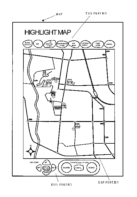
Fig. 1 is a diagram showing a surface printing state of
a map (medium) that is used herein.
The map used herein has an icon portion where an icon
is printed that instructs an operation for performing various
kinds of display on the display device, and a map portion where
roads, railroad lines, and tourist facilities are printed.
[0037]
In each icon region of the icon portion, a dot pattern
indicating a code corresponding to an operation instruction
is printed. A dot pattern printed therein will be described
below. The icon portion is printed in upper and lower sides
of the map. On the upper side, icons of ' information' ,'map' ,
'GS gasoline stand', 'convenience store', 'ATM bank',
'accommodation', 'places to eat', and 'cancel' are provided.
[0038]
On the lower side, icons of ' up' ,' right' ,' down' ,' left' ,
21
CA 02622238 2008-03-11
WO 2007/032747 PCT/SG2006/000267
and 'return' for moving the electronic map, and icons of
' enlarge' ,' normal' , and ' reduce' for changing the size of the
electronic map are printed.
[0039]
In the map portion, symbols indicating roads, railroad
lines, and tourist facilities are printed. In regions of the
map portion, dot patterns indicating XY coordinates
corresponding to positions of the roads or the railroad lines
are printed. Further, in the symbols, dot patterns obtained
by coding facility information or the like are superimposed
and printed, in addition to the XY coordinates corresponding
to the positions of the facilities or the like.
[0040]
Fig. 2 is an explanatory view showing a utilization state
of the map.
[0041]
As shown in the drawing, in the invention, the map (medium)
is used in connection with an electronic apparatus, such as
a personal computer, and a pen-type scanner (imaging unit).
That is, the pen-type scanner is connected to the computer by
a USB cable or the like. A user clicks (captures) an arbitrary
position or symbols on the map portion, or various icons printed
in the icon portion using the scanner.
[0042]
An address of the electronic map is registered in a map
22
CA 02622238 2008-03-11
WO 2007/032747 PCT/SG2006/000267
mode icon. If the user clicks the map mode icon, the electronic
map registered in a hard disk device of the personal computer
is read and then is output and displayed on a display.
Moreover, in Fig. 2, the scanner is connected to the
computer, but the invention is not limited thereto. For example,
the scanner may be used in connection with other communication
apparatuses, such as a cellular phone, a PDA (Personal Digital
Assistant), and the like.
[0043]
Fig. 3 is a hardware block diagram showing the
configuration of the computer and the scanner.
[0044]
As shown in Fig. 3, the personal computer has a central
processing unit (CPU) , a main memory (MM) , and a hard disk device
(HD) , a display device (DISP) as an output unit, and a keyboard
(KBD) as an input unit that are connected to the central
processing unit by a bus.
[0045]
Then, the scanner as an imaging unit is connected through
.a USB interface (USB I/F).
[0046]
Though not shown, in addition to the display device ( DISP ),
a printer, a speaker, and the like are connected as an output
unit.
[0047]
23
CA 02622238 2008-03-11
WO 2007/032747 PCT/SG2006/000267
The bus (BUS) is connected to a general-use network (NW) ,
such as Internet or the like, through a network interface (NW
I/F), such that electronic map data, character information,
image information, sound information, motion picture
information, programs, and the like can be downloaded from a
server (not shown).
[0048]
In the hard disk (HD), an operating system (OS),
application programs, such as an analysis program of a dot
pattern used in this embodiment or the like, and data, such
as electronic map data, character information, image
information, sound information, motion picture information,
or various tables, are registered.
[0049]
The central processing unit (CPU) sequentially reads the
application programs in the hard disk through the bus (BUS)
and the mainmemory (MM) and executes them. Further, the central
processing unit (CPU) reads out data and outputs and displays
the data on the display device (DISP) . As such, the functions
to be described in this embodiment are implemented.
[0050]
The scanner has an optical imaging element, such as an
infrared ray irradiation unit (red LED) and an IR filter, a
CMOS sensor, a CCD sensor, or the like, although not shown in
the drawing. The scanner has a function of imaging reflected
24
CA 02622238 2008-03-11
WO 2007/032747 PCT/SG2006/000267
light of irradiation light irradiated on a surface of the medium.
Here, the dot patterns on the surface of the medium are printed
with carbon ink, and portions other than the dot patterns are
printed with no-carbon ink.
[0051]
Carbon ink has a light absorption characteristic, and
thus only dot portions in the captured image by the optical
imaging element are imaged black.
[0052]
The captured image of the dot pattern read in such a manner
is analyzed by a central processing unit (CPU) in the scanner,
then is converted into a coordinate value or a code value, and
subsequently is transmitted to the personal computer through
a USB cable.
[0053]
The central processing unit (CPU) of the personal computer
refers to a table indicating the received coordinate value or
code value and causes the display device (DISP) or the speaker
(not shown) to output corresponding electronic map data,
character information, image information, sound information,
or motion picture information.
[0054]
Next, the dot pattern used herein will be described with
reference to Figs. 4 to 9D.
[0055]
CA 02622238 2008-03-11
WO 2007/032747 PCT/SG2006/000267
Fig. 4 is an explanatory view showing GRID1 as an example
of a dot pattern of the invention.
[0056]
Moreover, in the drawings,for convenience of explanation,
vertical and horizontal lattice lines are shown, but do not
exist on a printing surface. When the scanner as the imaging
unit has an infrared ray irradiation unit, key dots 2,
information dots 3, reference lattice point dots 4 and the like
constituting the dot pattern 1 are preferably printed with carbon
ink that absorbs infrared rays.
[0057]
Fig. 5 is an enlarged view showing an example of the
information dots of the dot pattern and bit display of data
defined therein. Figs. 6A and 6B are explanatory views showing
the information dots disposed around the key dot.
[0058]
An information input/output method using the dot pattern
of the invention includes generation of the dot pattern 1,
recognition of the dot pattern 1, and output of information
and programs from the dot pattern 1. That is, in order to read
the dot pattern 1 as image data by a camera, first, the reference
lattice point dots 4 are extracted, then the key dots 2 are
extracted on the basis of the fact that dots do not hit at positions
where the reference lattice point dots 4 are originally disposed,
and subsequently the information dots 3 are extracted. Assuch,
26
CA 02622238 2008-03-11
WO 2007/032747 PCT/SG2006/000267
through digitalization, the information regions are extracted
and then the information is digitalized. On the basis of the
digitalized information, the information and programs are
output from the dot pattern 1. For example, the information,
such as sound and the like, or programs are output from the
dot pattern 1 to an information output apparatus, a personal
computer, a PDA, or a cellular phone.
[0059]
In the invention, upon generation of the dot pattern 1,
fine dots for recognition of information, such as sound, that
is, the key dots 2, the information dots 3, and the reference
lattice point dots 4 are arranged according to predetermined
rules by a dot code generation algorithm. As shown in Fig.
4, in each block of the dot pattern 1 representing information,
x 5 reference lattice point dots 4 are disposed on the basis
of the key dots 2, and the information dot 3 is disposed in
the vicinity of a virtual lattice point 5 surrounded by four
reference lattice points 4. In the block, arbitrary
digitalized information is defined. Moreover, in the example
of Fig. 4, four blocks (in a bold-line frame) of the dot pattern
1 are arranged in parallel. Of course, the dot pattern 1 is
not limited to four blocks.
[0060]
One corresponding information and program may be output
to one block or may be output to a plurality of blocks.
27
CA 02622238 2008-03-11
WO 2007/032747 PCT/SG2006/000267
[0061]
When the dot pattern 1 is taken as image data by a camera,
imaging from distortion or slant of a lens of the camera,
expansion and contraction of the paper, curvature of thesurface
of the medium, and distortion upon printing can be corrected
using the reference lattice point dots 4. Specifically, the
correction function (Xn, Yn) = f(Xn' , Yn' ) for converting the
distorted four reference lattice point dots 4 into the original
rectangular shape is obtained, and the information dots 3 are
corrected by the same function so as to calculate a vector of
the correct information dots 3.
[0062]
If the reference lattice point dots 4 are disposed in
the dot pattern 1, as for image data obtained by taking the
dot pattern 1 using the camera, the distortion due to the camera
is corrected. Accordingly, even when the image data of the
dot pattern 1 is taken by a popular camera including a lens
having high distortion, the image data obtained by taking the
dot pattern 1 using the camera can be accurately recognized.
Further, even though the image data is taken in a state where
the camera is inclined with the respect to the surface of the
dot pattern 1, the dot pattern 1 can be accurately recognized.
[0063]
As shown in Fig. 4, the key dots 2 are dots that are formed
by disposing the four reference lattice point dots 4 at four
28
CA 02622238 2008-03-11
WO 2007/032747 PCT/SG2006/000267
corners of the block to be shifted in a predetermined direction.
The key dots 2 are representative points of the dot pattern
1 for one block representing theinformation dots 3. Forexample,
the reference lattice point dots 4 at the four corners of the
block of the dot pattern 1 are shifted by 0.2 mm upward. When
the information dots 3 represent X and Y coordinates, the
positions where the key dots 2 are shifted by 0.2 mm downward
become coordinate points. However, this numerical value is
not limited thereto, but may vary according to the size of the
block of the dot pattern 1.
[0064]
The information dots 3 are dots for the recognition of
information. The information dots 3 are arranged around the
key dot 2 as a representative point, and simultaneously are
disposed at end points expressed by a vector with the virtual
lattice point 5, that is, the center surrounded by the four
reference lattice point dots 4, as a start point. For example,
the information dots 3 are respectively surrounded by the
reference lattice point dots 4 and, as shown in Fig. 5, the
dots spaced from the virtual lattice point 5 by 0.2 mm have
direction and length expressed by the vector. Then, these dots
are rotated by 45 degrees in a clockwise direction and then
disposed in eight directions. These dots represent three bits.
Therefore, three bits x 16 = 48 bits can be expressed by the
dot pattern 1 of one block.
29
CA 02622238 2008-03-11
WO 2007/032747 PCT/SG2006/000267
[0065]
Moreover, in the example shown in the drawing, the three
bits are expressed by disposing the dots in the eight directions,
but the invention is not limited thereto. For example, four
bits can be expressed by disposing the dots in 16 directions.
Of course, other changes can be made.
[0066]
The diameter of the key dot 2, the information dot 3,
or the reference lattice point dot 4 is preferably about 0.1
mm in consideration of visual quality, printing accuracy to
paper quality, resolution of the camera, and optimum
digitalization.
[0067]
Further, a gap between the reference lattice point dots
4 is about 1 mm in the horizontal/vertical direction in
consideration of a required information amount for an imaging
area and misrecognition of various dots 2, 3, and 4. The shift
amount of the key dot 2 is preferably about 20% of the lattice
gap in consideration of misrecognition of the reference lattice
point dot 4 and the information dot 3.
[0068]
A gap between the information dot 3 and the virtual lattice
point surrounded by the four reference lattice point dots 4
is preferably a gap of 15 to 30% of a distance between adjacent
virtual lattice points 5. If a distance between the information
CA 02622238 2008-03-11
WO 2007/032747 PCT/SG2006/000267
dot 3 and the virtual lattice point 5 is shorter than the gap,
the dots are likely to be recognized as a large lump and are
difficult to be considered as the dot pattern 1. In contrast,
if the distance between the information dot 3 and the virtual
lattice point 5 is longer than the gap, it is difficult to
recognize whether or not the information dot 3 keeps vector
directionality around an adjacent virtual lattice point 5.
[0069]
For example, as shown in Fig. 6A, the information dots
3 of I1 to 116 are arranged from the center of the block in a
clockwise direction to have a lattice gap of 1 mm and represents
3 bits x 16 = 48 bits by 4 mm x 4 mm.
[0070]
Moreover, subblocks that have individual information
contents having no effect on other information content may be
provided in the block. Fig. 6B shows these subblocks. In the
subblocks [I1, 12, 13, In] .[Is, 16, 17, I8] , [I9, IiO, I11, I12] ,
and [I13, I14, 115, 1161, each having four information dots 3,
independent data (3 bits x 4 = 12 bits) are expanded in the
information dots 3. As such, if the subblocks are provided,
error check can be easily performed in subblocks.
[0071]
Preferably, vector directions (rotation direction) of
the information dots 3 are uniformly determined for every 30
to 90 degrees.
31
CA 02622238 2008-03-11
WO 2007/032747 PCT/SG2006/000267
[0072]
Fig. 7 is a diagram showing an example of the information
dot 3 and bit display of data defined therein, and shows another
embodiment.
[0073]
For the information dots 3, two long and short dots from
the virtual lattice point 5 surrounded by the reference lattice
point dots 4 are used. If the vector directions are 8 directions,
4 bits can be represented. At this time, the longer dot is
preferably about 25 to 30% of the distance between adjacent
virtual lattice points 5 and the shorter dot is preferably about
15 to 20% thereof. However, an inter-center gap between the
long and short information dots 3 is preferably longer than
the diameter of the dot.
[0074]
The number of information dots 3 surrounded by the four
referencelattice point dots 4 is pref erably one in consideration
of visual quality. However, when a desired information amount
is large regardless of visual quality, one dot is assigned for
one vector, and a plurality of information dots 3 are represented,
thereby having a large amount of information. For example,
in case of an eight-directional vector of a concentric circle,
the information dots 3 surrounded by the four reference lattice
point dots 4 can represent information of 28. The 16 information
dots of one block become 2128.
32
CA 02622238 2008-03-11
WO 2007/032747 PCT/SG2006/000267
[0075]
Figs. 8A to 8C show examples of the information dot and
bit display of data defined therein. Specifically, Fig. 8A
shows a case where two dots are disposed, Fig. 8B shows a case
where four dots are disposed, and Fig. 8C shows a case where
five dots art disposed.
[0076]
Figs. 9A to 9D show modifications of the dot pattern.
Specifically, Fig. 9A is a schematic view showing a case where
six information dots are disposed, Fig. 9B is a schematic view
showing a case where nine information dots are disposed, Fig.
9C is a schematic view showing a case where 12 information dots
are disposed, and Fig. 9D is a schematic view showing a case
where 36 information dots are disposed.
[0077]
In the dot patterns 1 shown in Figs. 4 and Figs. 6A and
6B, 16 (4 x 4) information dots 3 are disposed in one block.
However, the invention is not limited to the 16 information
dots 3, but various changes can be made. For example, according
to the size of a required information amount or resolution of
the camera, 6 (2 x 3) information dots 3 may be disposed in
one block (a), 9 (3 x 3) information dots 3 may be disposed
in one block (b), 12 (3 x 4) information dots 3 may be disposed
in one block (c) , or 36 information dots 3 may be disposed in
one block (d).
33
CA 02622238 2008-03-11
WO 2007/032747 PCT/SG2006/000267
[0078]
Next, Figs. 10A and 10B show the relationship between
the dot pattern printed on the surface of the map, and the code
value and the XY coordinate value.
[0079]
Fig. 10A shows values, which are defined by 32 bits of
Co to C31 of the dot pattern, by a table. Co to C7 represent
X coordinates, Ca to C15 represent Y coordinates, C16 to C27
represent map numbers, C28 to C30 represent parity bits, and
C31 represents XY map data.
[0080]
Moreover, C16 to CZ7 are not limited to map numbers, but
may represent other codes (code value).
[0081]
These values are disposed in lattice regions shown in
Fig. 10B.
[0082]
As such, in this dot pattern, the X coordinates, the Y
coordinates, and corresponding code information (code values)
can be registered in 4 x 4 lattice regions. Accordingly,
specific code information can be given to a region of a symbol
on the map, together with the XY coordinates. With the
formatting of such a dot pattern, the information based on the
XY coordinates, and texts, images, motion pictures, and sound
information corresponding to a symbol icon of a building or
34
CA 02622238 2008-03-11
WO 2007/032747 PCT/SG2006/000267
the like can be associated and output.
[0083]
Figs. 11A and 11B are diagrams illustrating an operation
that enlarges or reduces an electronic map by clicking an icon
displayed on the lower side of the icon portion.
[0084]
Fig. 11A is a diagram showing an operation that is
performed on the map by a user, and Fig. 11B is a diagram showing
a video that is displayed on the display device (monitor) when
the corresponding operation is performed. As shown in Fig.
11A, if the user clicks the symbol 'enlarge' located on the
lower side of the icon portion using the scanner, an imaging
element captures the dot pattern printed on the symbol. Then,
the capturedimage is analyzedbythe internal central processing
unit (CPU) of the scanner, then is converted into a dot code
(coordinate value or code value), and subsequently is
transmitted to the personal computer.
[0085]
The central processing unit (CPU) of the personal computer
refers to a table in the hard disk device (HD) on the basis
of the dot code, reads image data (in this example, enlarged
data of the electronic map) stored corresponding to the dot
code, and displays that on the display device (monitor).
[0086]
The central processing unit (CPU) may perform a display
CA 02622238 2008-03-11
WO 2007/032747 PCT/SG2006/000267
control of the display device (DISP) on the basis of the dot
code, andmay directly enlarge the image data of the map displayed
on the display (monitor).
[0087]
In such a manner, as shown in Fig. 8B, the magnification
of the electronic map on the display device (monitor) is enlarged.
Similarly, if the symbol ' reduce ' is clicked, the magnification
of the electronic map is reduced. If the symbol 'normal' is
clicked, the.normal magnification returns.
[0088]
Figs. 12A and 12B are diagrams illustrating an operation
that moves a map to be displayed on the display device (monitor)
by clicking an icon displayed on the lower side of the icon
portion.
[0089]
In Fig. 12A, if the icon 'right' is clicked (captured
by the scanner) , the central processing unit (CPU) of the scanner
analyzes the dot pattern of the icon by an analysis program,
converts the dot pattern into the dot code (coordinate value
or code value), and transmits the converted dot code to the
personal computer.
[0090]
The central processing unit(CPU)of the personal computer
that receives the dot code refers to the table in the hard disk
device (HD) on the basis of the dot code, reads out the image
36
CA 02622238 2008-03-11
WO 2007/032747 PCT/SG2006/000267
data (in this example, map data on the right side than the
coordinate position of the electronic map) stored corresponding
to the dot code, and displays the image data on the display
device (monitor).
[0091]
The central processing unit (CPU) may perform a display
control of the display device (DISP) on the basis of the dot
code, and may directly move and draw the image data of the map
displayed on the display (monitor).
[0092]
In the above-described embodiment, an example where the
image data displayed on the display device (DISP) moves in the
left direction on the screen by the icon 'right' has been
described, but the image data may move in the right direction.
[0093]
Similarly, if the user clicks ' left' , the image data of
the map is scrolled leftward (or rightward) . If 'up' is clicked,
the image data of the map is scrolled upward (or downward),
and, if 'down' is clicked, it is scrolled downward (or upward) .
In addition, if 'return' is clicked, the image data of the map
returns to the state before the scroll.
[0094]
Figs. 13A and 13B are diagrams illustrating an operation
that scrolls the electronic map by clicking the map by the user.
[0095]
37
CA 02622238 2008-03-11
WO 2007/032747 PCT/SG2006/000267
Figs. 13A and 13B are diagrams illustrating a case where
the user clicks an arbitrary position, such as a road, a river,
or the like on the map. Specifically, Fig. 13A is a diagram
showing an operation that is performed on the map by the user,
and Fig. 13B is a diagram showing a video that is displayed
on the display device (monitor) when the corresponding operation
is performed. For example, as shown in Fig. 13A, if the user
clicks a cross of the road using the scanner, the central
processing unit (CPU) of the scanner analyzes the dot pattern
by an analysis software program. The dot code is transmitted
to the central processing unit (CPU) of the computer. The
computer reads only a code representing the XY coordinates of
that position in the dot code. In such a manner, as shown in
Fig. 13B, the image data of the map is scrolled such that the
cross is located at the center of the display.
[0096]
According to the invention, a click point is not limited
to the road or river, but may be a symbol on the map, such as
a gas station or the like. If the user clicks the symbol,
according to the above-described method, the code representing
the XY coordinates of the symbol is read, and the image data
of the map is scrolled such that the symbol is located at the
center of the display.
[0097]
Figs. 14A and 14B are diagrams illustrating an operation
38
CA 02622238 2008-03-11
WO 2007/032747 PCT/SG2006/000267
that scrolls the electronic map by a grid drag operation.
[0098]
Fig. 14A is a diagram showing an operation that is
performed on the map by the user, and Fig. 14B is a diagram
showing a video that is displayed on the display when the
corresponding operation is performed. Here, the grid drag
operation refers to move the scanner in a state where the scanner
is in contact with the map portion. In this example, the user
initially clicks the center of the cross, and moves the scanner
to the center of the map portion so as not to be separated from
the map portion. With this operation, as shown in Fig. 14B,
the screen is scrolled such that the center of the cross is
located at the center of the display.
[0099]
With this operation, first, the scanner reads the
coordinate value of the cross, and then the coordinate value
changes as the scanner moves.
[0100]
The coordinate values changed in such a manner are
sequentially transmitted to the personal computer. The central
processing unit (CPU) of the personal computer moves (scrolls)
the electronic map displayed on the display device (monitor)
on the basis of the change of the coordinate value. As a result,
according to the invention, the electronic map is scrolled such
that the clicked point is displayed at the center of the display.
39
CA 02622238 2008-03-11
WO 2007/032747 PCT/SG2006/000267
[0101]
Figs. 15A and 15B are diagrams illustrating a search
function of facilities or the like.
[0102]
Fig. 15A is a diagram showing an operation that is
performed on the map by the user, and Fig. 15B is a diagram
showing a video that is displayed on the display device (monitor)
when the corresponding operation is performed.
[0103]
If the user clicks any one icon of 'GS', 'ATM',
' accommodation' , and 'places to eat' printed on the upper side
of the map, an icon symbol indicating the facility corresponding
to the symbol is displayed on the electronic map. For example,
as shown in Fig. 15A, if the user clicks the icon ' GS' , as shown
in Fig. 15B, a symbol ' GS' indicating a gas station is displayed
at a position on the electronic map where the gas station exists.
Similarly, if the user clicks the icon 'ATM', an icon indicating
an ATM of a bank or the like is displayed. Further, if the
user clicks the icon 'accommodation', a symbol indicating a
lodging facility, such as a hotel or an inn, is displayed, and,
if the user clicks the symbol ' places to eat' , a symbol indicating
a restaurant is displayed. Accordingly, the user can easily
know where a target facility is located.
[0104]
Here, in the icons 'GS', 'ATM', 'accommodation', and
CA 02622238 2008-03-11
WO 2007/032747 PCT/SG2006/000267
' places to eat' , a code value is printed as a dot pattern for
every predetermined number of icons. Then, if the imaging
element of the scanner reads the dot pattern as the captured
image, the central processing unit (CPU) of the scanner converts
the dot pattern into the code value on the basis of the analysis
program of a ROM, and transmits the code value to the personal
computer.
[0105]
The central processing unit (CPU) of the personal computer
searches the table on the basis of the code value, and maps
and displays a symbol image corresponding to the code value
on an electronic map image displayed on the display (monitor)
[0106]
In a state where the symbol is displayed on the electronic
map, if the user clicks the icon corresponding to the symbol,
the symbol on the electronic map is removed.
[0107]
Figs. 16A and 16B are diagrams illustrating an inf ormation
mode.
[0108]
The information mode refers to a state where information
(characters, images, sound, motion pictures, and the like)
corresponding to the symbol on the map is explained.
[0109]
In this embodiment, in an initial setting, a map mode
41
CA 02622238 2008-03-11
WO 2007/032747 PCT/SG2006/000267
is set. In order to switch from the map mode to the information
mode, as shown in Fig. 16A, the user first clicks the icon
'information' on the upper side of the icon portion.
Accordingly, a switching processing from the map mode to the
information mode is performed.
[0110]
Specifically, in the icon ' information', a predetermined
code value is printed as a dot pattern. Then, if the imaging
element of the scanner reads the dot pattern as image data,
the central processing unit (CPU) of the scanner converts the
dot pattern into the code value by the analysis program of the
ROM, ad transmits the code value to the personal computer.
[0111]
The central processing unit (CPU) of the personal computer
that receives the code value switches a display mode of the
display (monitor) to the information mode.
[0112]
Next, the user clicks a symbol indicating a facility whose
information is desired. For example, as shown in Fig. 16A,
the user clicks a symbol of a temple. Then, a code value
indicating the temple is transmitted to the personal computer.
The central processing unit (CPU) of the personal computer that
receives the code value of the temple searches the table on
the basis of the code value and outputs information (characters,
images, sound, motion pictures, and the like) corresponding
42
CA 02622238 2008-03-11
WO 2007/032747 PCT/SG2006/000267
to the code value from the display (monitor) . Here, the video
of the temple is displayed on the display, and sound for
explaining the temple is output from the speaker.
[0113]
Figs. 17A to 17C are diagrams illustrating a method of
switching from the map mode to the information mode.
[0114]
As shown in Figs. 16A and 16B, on the upper side of the
icon portion, two icons of 'information' and 'map' are printed.
However, mode switching can be performed by an operation of
the scanner, instead of clicking these icons.
[0115]
Fig. 17A shows a case where switching is performed by
a grid tapping operation. The grid tapping operation refers
to an operation that stands the scanner in a direction
perpendicular to the map and hits against the map while moving
the scanner up and down. For example, if the user performs
the grid tapping operation on the symbol of the temple, switching
from the map mode to the information mode is performed, and
the video of the temple is displayed on the display (monitor)
[0116]
Specifically, the central processing unit (CPU) of the
personal computer recognizes that the grip tapping operation
is performed when the substantially same XY coordinate
information or code information are read in a predetermined
43
CA 02622238 2008-03-11
WO 2007/032747 PCT/SG2006/000267
time multiple times.
[0117]
Fig. 17B shows a case where switching is performed by
a grid sliding operation. The grid sliding operation refers
to an operation that circularly slides the scanner on the map.
The user performs the grid sliding operation so as to surround
the symbol. Accordingly, switching from the map mode to the
information mode is performed, and the video of the temple is
displayed on the display (monitor).
[0118]
Specifically, the central processing unit (CPU) of the
personal computer recognizes that the grip sliding operation
is performed when XY coordinate information read in a
predetermined time by the circular grid sliding operation of
the imaging unit on the surface of the medium is recognized
as a substantially circular trace.
[0119]
Fig. 17C shows a case where switching is performed by
a grid scratch operation. The grid scratch operation refers
to an operation that moves the scanner on the map several times
as a scratch. The user performs the grid scratch operation
on the symbol. Accordingly, switching from the map mode to
the information mode is performed, and the video of the temple
is displayed on the display (monitor).
[0120]
44
CA 02622238 2008-03-11
WO 2007/032747 PCT/SG2006/000267
Specifically, the central processing unit (CPU) of the
personal computer recognizes that the grip scratch operation
is performed when a trace of XY coordinates read in a
predetermined time is recognized as a repetition of a short
linear trace (scratch).
[0121]
The operation of the scanner for switching from the map
mode to the information mode is not limited to the
above-described embodiment. With other operations than the
above-described operations by the user, switching to the
information mode may be performed.
[0122]
Figs. 18A to 18C are diagrams illustrating an operation
that scrolls the electronic map according to an orientation
of the scanner (grid tilt operation) . Specifically, Fig. 18A
is a diagram illustrating an operation of the user, Fig. 18B
is a diagram illustrating a case where the inclination of the
scanner changes with respect to the vertical direction, and
Fig. 18C is a diagram illustrating a state where the electronic
map is being scrolled on the display (monitor).
[0123]
The orientation of the scanner refers to an orientation
in which a frame buffer becomes upward upon imaging. As shown
in Fig. 18A, the user sets the orientation of the scanner in
a direction to be scrolled and clicks. Then, a position where
CA 02622238 2008-03-11
WO 2007/032747 PCT/SG2006/000267
the user clicks is scrolled in a direction indicated by the
orientation of the scanner.
[0124]
In this case, a scroll distance of the electronic map
is determined by the inclination of the scanner with respect
to the vertical line of the map and an angle between the scanner
and the map. In Fig. 18B, (1) shows a state where the scanner
stands upright before inclined, (2) shows a state where the
scanner is inclined forward, (3) shows a state where the scanner
is further inclined forward, (4) shows a state where the scanner
is inclined backward, and (5) shows a state where the scanner
is further inclined backward. As such, the operation that
inclines the scanner forward or backward is referred to as grid
tilt. For each case, Fig. 18C illustrates how the electronic
map is scrolled on the display (monitor) . It is assumed that
a point on the map portion clicked by the user is located at
the center of the screen before the scanner is inclined. Then,
when the scanner is inclined forward, the electronic map moves
in parallel with the same direction as a direction indicated
by the orientation of the scanner. Further, if the scanner
is deeply inclined, a moving speed and a moving distance increase.
Meanwhile, when the scanner is inclined backward, the electronic
map moves in a direction opposite to the direction indicated
by the orientation of the scanner by 180 degrees. Like a case
where the scanner is inclined forward, as the scanner is deeply
46
CA 02622238 2008-03-11
WO 2007/032747 PCT/SG2006/000267
inclined, the moving speed and the moving distance increase.
[0125]
Figs. 19A to 19C are diagrams illustrating an operation
that scrolls the map displayed on the display device (monitor)
according to the inclination of the scanner with respect to
the orientation of the dot pattern. Specifically, Fig. 19A
is a diagram illustrating the operation of the user, Fig. 19B
is a diagram illustrating a case where the inclination of the
scanner with respect to the vertical direction changes, and
Fig. 19C is a diagram illustrating a state where the electronic
map is scrolled on the display (monitor).
[0126]
The inclination of the scanner refers to an angle between
the orientation of the dot pattern and a scanner main body.
The electronic map is scrolled in a direction in which the scanner
is inclined.
[0127]
A scroll distance is determined by a depth at which the
scanner is inclined. In Fig. 19B, (1) shows a state where a
pen stands upright before inclined, (2) shows a state where
the pen is inclined forward, and (3) shows a state where the
pen is further inclined forward. For each case, Fig. 19C
illustrates how the electronic map is scrolled on the display
(monitor). It is assumed that a point on the map clicked by
the user is located on a lower right side of the screen before
47
CA 02622238 2008-03-11
WO 2007/032747 PCT/SG2006/000267
the scanner is inclined. When the scanner is inclined forward,
the electronic map moves in parallel with the same direction
as the direction indicated by the orientation of the scanner.
Further, as the scanner is deeply inclined, the moving speed
and the moving distance increase.
[0128]
The direction in which the scanner is inclined and the
scroll direction of the electronic map on the display may be
reversed.
[0129]
Figs. 20A to 20C are diagrams illustrating the
relationship between the inclination of the scanner and an angle
at which the map on the display (monitor) is scrolled.
[0130]
The dot pattern on the map is superimposed and printed
in the same direction as a vertical direction of the paper.
As shown in Fig. 20A, it is assumed that an angle between the
orientation of the dot pattern and the orientation of the scanner
is a. Further, as shown in Fig. 20B, it is assumed that, when
the user inclines the scanner, an angle between the inclination
of the scanner and the orientation of the scanner is P. In
this case, the electronic map moves in a direction of an angle
y between the inclination of the scanner and the orientation
of the dot. That is, the angle y becomes as follows.
7 + (3.
48
CA 02622238 2008-03-11
WO 2007/032747 PCT/SG2006/000267
[0131]
The inclination of the scanner can be recognized by a
difference in brightness in an imaging field, and this will
be described below.
[0132]
Figs. 21A and 21B are diagrams illustrating an operation
of the scanner for enlarging the screen displayed on the display
(monitor) by a grid grind operation.
[0133]
The grid grind operation refers to an operation that
rotates the scanner. Fig. 21A is a diagram showing an operation
that is performed on the map by the user, and Fig. 21B is a
diagram showing a video that is displayed on the display
(monitor) when the corresponding operation is performed. As
shown in Fig. 21A, if the user performs the grid grind operation
of the scanner in a right direction, as shown in Fig. 21B, the
electronic map is enlarged.
[0134]
The grid grind operation is an operation that rotates
the scanner, and the grid grind operation in the right direction
is referred to as 'grid grind right'.
[0135]
Specifically, the central processing unit (CPU) of the
personal computer recognizes that the grid grind operation is
performed when, in an inclined state where an imaging optical
49
CA 02622238 2008-03-11
WO 2007/032747 PCT/SG2006/000267
axis keeps a predetermined inclination with respect to the
vertical line of the surface of the medium, a change in the
inclined state of the imaging optical axis is recognized
according to the rotation around the vertical line.
[0136]
Figs. 22A and 22B are diagrams illustrating an operation
of the scanner for reducing the screen displayed on the display
(monitor) by a grid grind operation.
[0137]
Fig. 22A is a diagram showing an operation that is
performed on the map by the user, and Fig. 22B is a diagram
showing a video that is displayed on the display (monitor) when
the corresponding operation is performed. As shown in Fig.
22A, if the user performs the grid grind operation of the scanner
in a left direction, as shown in Fig. 22B, the electronic map
is reduced.
[0138]
As such, the grid grind operation in the left direction
is referred to as 'grid grind left'.
[0139]
(Second Embodiment: Three-dimensional Map)
Figs. 23A to 31C relate to a second embodiment of the
invention and illustrate display of a three-dimensional map
when an electronic map is a three-dimensional map.
[0140]
CA 02622238 2008-03-11
WO 2007/032747 PCT/SG2006/000267
In this embodiment, like the planar map, a map on which
dot patterns are superimposed and printed is also used in
connection with an electronic apparatus, such as a computer
or the like. That is, if an arbitrary point on the map, such
as a mountain or a pond is clicked using the scanner, a
three-dimensional image corresponding to that point is
displayed on the display (monitor).
[0141]
Figs. 23A and 23B show the relationship between a dot
pattern printed on the surface of the map, and a code value
and an XYZ coordinate value.
[0142]
Fig. 23A shows values, which are defined by 32 bits of
Co to C31 of the dot pattern, by a table. Co to C7 represent
X coordinates, C8 to C15 represent Y coordinates, C16 to C23
represent Z coordinates, C24 to C27 represent map numbers, C28
to C30 represent parity bits, and C31 represents XYZ map data.
[0143]
Moreover, C24 to C27 are not limited to map numbers, but
may represent other codes (code value).
[0144]
These values are disposed in lattice regions shown in
Fig. 23B.
[0145]
Figs. 24A to 24C are diagrams illustrating an operation
51
CA 02622238 2008-03-11
WO 2007/032747 PCT/SG2006/000267
that changes a view point by the above-described grid grind
operation.
[0146]
Fig. 24A is a diagram illustrating a case where the scanner
rotates in a counterclockwise direction, Fig. 24B is a diagram
illustrating a case where the scanner rotates in a clockwise
direction, and Fig. 24C is a diagram illustrating a change in
view point in Figs. 24A and 24B.
[0147]
In Fig. 24C, Z denotes an altitude at a point clicked
by the user. If the user clicks an arbitrary point, a scene
viewed from the point clicked by the user is displayed on the
display device (monitor) as a three-dimensional image. In this
case, a view point becomes Z + h1 as the sum of the altitude
and the height of human's eyes, and this view point becomes
a normal view point. As shown in Fig. 24A, if the user rotates
the scanner in the counterclockwise direction, the view point
rises to a position (1) . Then, as shown in Fig. 24B, if the
scanner rotates in the clockwise direction, the risen view point
falls.
[0148]
Figs. 25 and 26A to 26C are diagrams illustrating an
operation that tilts up or down the view point according to
the orientation of the scanner.
[0149]
52
CA 02622238 2008-03-11
WO 2007/032747 PCT/SG2006/000267
Fig. 25 is a diagram illustrating a user's operation on
the map. As indicated by (1) , the user first places the scanner
perpendicularly to the map. Then, as shown in Fig. 26A, the
electronic map is displayed on the display (monitor) in a normal
mode. As indicated by (2) of Fig. 25, if the user inclines
the scanner forward, as shown in Fig. 26B, the view point moves
downward as if a person's posture falls forward. Further, as
indicated by (3) of Fig. 25, if the scanned is inclined backward,
as shown in Fig. 26C, the view point moves upward as if a person
pulls back his/her upper part.
[0150]
Figs. 27A to 28B are diagrams illustrating an operation
that changes an angle by inclining the scanner left or right.
[0151]
In Fig. 27A, (1) shows a state where the scanner stands
upright with respect to the map, (2) shows a state where the
scanner is inclined left, and (3) shows a state where the scanner
is inclined right.
[0152]
In the state (1), the three-dimensional map is displayed
on the display (monitor) in a normal mode. As indicated by
(2), if the user inclines the scanner left, as shown in Fig.
28A, a screen is displayed in a state where the view point moves
left. As indicated by (3), if the user inclines the scanner
right, as shown in Fig. 28B, a screen is displayed in a state
53
CA 02622238 2008-03-11
WO 2007/032747 PCT/SG2006/000267
where the view point moves right.
[0153]
Figs. 29A to 30B are diagrams illustrating an operation
that changes a magnification of the map displayed on the screen
by a grid pump operation.
[0154]
The grid pump operation is an operation that quickly the
scanner forward or backward repeatedly. Before the grid pump
operation is performed, as shown in Fig. 29B, the same screen
as an image when a normal lens of the camera is captured is
displayed on the display (monitor). As indicated by (1) of
Fig. 29A, if the user quickly inclines the pen forward repeatedly,
as shown in Fig. 30A, the image is gradually enlarged, and the
same screen as an image captured using a telephoto lens is
displayed. Further, as indicated by (2) of Fig. 29A, if the
pen is quickly inclined backward repeatedly, a field angle is
gradually widened and, as shown in Fig. 30B, a screen when an
image is captured using a wide lens is displayed.
[0155]
Figs. 31A to 31C are diagrams illustrating an operation
that resets a view point operation by the grid tapping operation.
[0156]
The grid tapping operation is an operation that stands
the scanner perpendicularly to the map and hits against the
map while moving the scanner up and down.
54
CA 02622238 2008-03-11
WO 2007/032747 PCT/SG2006/000267
[0157]
For example, as shown in Fig. 31B, it is assumed that
a screen captured by the wide lens at a high-altitude position
by the above-described grid pump operation is displayed. In
this case, as shown in Fig. 31A, if the grid tapping operation
is performed, as shown in Fig. 31C, the display mode is reset
to the normal mode.
[0158]
Even in a telephoto mode by the grid pump operation,
similarly, the display mode is reset to the normal mode.
[0159]
Even when the view point changes by the grid grind
operation described with reference to Figs. 24A to 24C, the
view point is reset by the grid tapping operation.
[0160]
Figs. 32A and 32B show another embodiment of the scanner.
[0161]
Fig. 32A shows a state where the scanner is fixed by a
tripod tool. An opening is provided at the center of the tool,
and rubber is formed around the opening. The scanner is inserted
into the opening in use. With this structure, when the user
performs an operation, such as a grid grind or the like, the
scanner can be fixed, and the sensor unit can be prevented from
reading a dot pattern other than a target dot pattern.
[0162]
CA 02622238 2008-03-11
WO 2007/032747 PCT/SG2006/000267
Fig. 32B shows a state where the scanner is fixedby springs
in a cup-like tool. Openings are provided at upper and lower
parts of the tool, and a plurality of springs are provided at
the upper part. The scanner is fixed by the springs in use.
[0163]
In the known scanner, when the user performs various
operations using thescanner,a bottompart slightlymovesduring
rotation, and the dot pattern cannot be accurately read. In
contrast, with the above-described structure, the bottom part
is fixed, and thus the dot pattern can be accurately read.
Further, with rubber or springs, the user can smoothly perform
the operation.
[0164]
Figs. 33A to 37 are diagrams illustrating a method of
calculating an inclination direction when the scanner is
inclined.
[0165]
The inclination of the scanner with respect to the vertical
direction of the surface of the medium (map) can be recognized
by a difference in brightness in imaging field of the scanner,
as shown in Fig. 20B.
[0166]
The inclination direction of the scanner refers to an
angle between the scanner and the map, as shown in Fig. 34A.
Which direction the user inclines the scanner can be calculated
56
CA 02622238 2008-03-11
WO 2007/032747 PCT/SG2006/000267
by the following method.
[0167]
First, calibration is performed. The scanner stands
upright with respect to the map, and then brightness of cells
1 to 48 shown in Fig. 33 is measured. Fig. 33 shows a region
around the scanner. It is assumed that brightness at that time
is BLO (i) . .i is the value of the measured cell. For example,
brightness of the 24th cell is represented by BLO(24).
[0168]
In the scanner, two LEDs are provided. For this reason,
even though the scanner stands upright with respect to the map,
there is a difference in brightness between a cell around the
LED and a cell spaced from the LED. Accordingly, the calibration
is performed.
[0169]
Next, brightness when the scanner is inclined is measured.
As shown in Fig. 34B, brightness of the cells 1 to 48 when the
scanner is inclined in a predetermined direction is measured.
It is assumed that brightness of the cell i is BL(i). Next,
a difference between BL (i) and BLO (i) in each cell is measured.
Next, the following is calculated.
Max (BLO(i) - BL(i))
[0170]
When the scanner is inclined, a direction opposite to
the inclination direction is darkened. This is because the
57
CA 02622238 2008-03-11
WO 2007/032747 PCT/SG2006/000267
LED is also inclined in the inclination direction of the scanner,
and thus the distance from the LED becomes more distant in the
direction opposite to the inclination direction. Accordingly,
as shown in Fig. 34B, a direction opposite to the cell having
the maximum difference becomes a position where the scanner
is inclined.
[0171]
Then, the inclination direction of the scanner is
determined.
[0172]
Figs. 33A to 34B show another method of determining the
inclination direction and the angle by performing the
calibration.
[0173]
Initially, the calibration is performed. First, the
scanner stands upright with respect to the map, and brightness
of the cells 1 to 48 shown in Fig. 33A is measured. It is assumed
that brightness in the cell i is BLO(i).
[0174]
Next, the scanner is inclined by 45 , and goes round with
the tip of the pen as an axis, as shown in Fig. 35. In this
case, it is assumed that brightness when the scanner is located
at a position of the cell i is BL45 (i) . BL45 (i) from the cells
1 to 48 are measured. With the above operations, the calibration
is completed.
58
CA 02622238 2008-03-11
WO 2007/032747 PCT/SG2006/000267
[0175]
Next, when the user inclines the scanner, brightness of
the cells 1 to 48 is measured. It is assumed that brightness
of the cell i is BL ( i), and i= 1, n (4 8). Next, the following
is calculated.
[Equation 1]
Max BLO(i) - BL(i) ~ i=1, n = 1, n(= 48)
BLO(i) - BL45(i)
[0176]
Since BLO(i) - BL45(i) is constant, when the value of
BLO(i) - BL(i) has the maximum, that is, when BL(i) has the
minimum, the following has the maximum.
[Equation 2]
BLO(i) - BL(i) 5i=1, n=1, n(= 48)
BLO(i) - BL45(i)
As described above, since the direction opposite to the
inclination direction of the scanner is most darkened, the
direction opposite to the cell i in this case becomes the
inclination direction of the scanner.
[0177]
The inclination angle of the scanner is as follows.
[Equation 3]
8= 45 x BLO(i) - BL(i) 5i=1, n=1, n(= 48)
BLO(i) - BL45(i)
[0178]
59
CA 02622238 2008-03-11
WO 2007/032747 PCT/SG2006/000267
In the above-described equation, it is assumed that an
angle 0 is linear with respect to brightness, but strictly,
the following approximation using a trigonometrical function
results in an increase in accuracy. Then, the angle is as
follows.
[Equation 4]
9= I cos-1 r_BL(i) - BL45(i)
-
2 BL0(i) - BL45(i)
[0179]
Fig. 36 shows a method of measuring the inclination
direction using a Fourier function.
[0180]
As shown in Fig. 35, eight cells of the cells 1 to 8 are
selected as measurement points, and brightness of each cell
is measured.
A sine function is represented as follows.
aj {sin(1/2) j - 1 (0 - (3j) }
That is, the number of unknown quantities is two.
[0181]
Therefore, when n measurement points are provided, the
number of discrete points becomes n. Accordingly, the sum of
n/2 sine functions is calculated, and this becomes brightness
BL(i) at a radius from the analysis center. That is, the
following is represented.
[Equation 5]
CA 02622238 2008-03-11
WO 2007/032747 PCT/SG2006/000267
Z 1~
BL(i) =Yaj sin(12 J (8 -,8j)
j=1
However, n = 2m (where n is the number of measurement
points).
[0182]
In this embodiment, since the number of measurement points
is 8, n= 8. Accordingly, a1 to a4 and 01 to (34 of Fourier
series are calculated by synthesizing equations of four sine
functions. Then, brightness BL(i) at the radius from the
analysis center is represented by the sum of the four sine
functions.
[0183]
From the above equation, the angle 0 having the minimum
BL(i) becomes the darkest position, and a direction opposite
thereto by 180 degrees becomes the inclination direction of
the scanner.
[0184]
Fig. 37 shows a method of measuring the inclination
direction by analyzing an equation of the n-th degree.
[0185]
A graph of Fig. 37 shows a function of the n-th degree.
When the function of the n-th degree is used, brightness BL (i)
at the radius from the analysis center is as follows.
BL (i) = al (0 - (31) = a2 (0 - (32) ... aj (0 - (3j )
However, j = n/2 and n = 2m.
61
CA 02622238 2008-03-11
WO 2007/032747 PCT/SG2006/000267
[0186]
As shown in Fig. 35, in this embodiment, since the number
of measurement points is 8, it is necessary to calculate eight
solutions. Since two unknown quantities of aj and Pj are
included in one equation, four solutions of the equation are
calculated, and then al to a4 and (31 to (34 are calculated.
[0187]
Accordingly, the angle 0 at which BL (i) becomes the minimum
is calculated. A position having an angle 0 is the darkest
position, and a direction opposite thereto by 180 degrees becomes
the inclination direction of the scanner.
[0188]
In the measurement method according to Figs. 36 and 37,
the inclination of the scanner with respect to the vertical
line of the map cannot be measured. Then, in connection with
the measurement method shown in Figs. 33A to 34B, the inclination
angle can be specifically measured.
[0189]
Figs. 38A to 38C are explanatory views showing another
embodiment of the search function of facilities and the like
described with reference to Figs. 15A and 15B.
[0190]
In this embodiment, if the user performs the grid drag
operation, a designated range is determined on the basis of
the trace, and a facility or the like designated by the user
62
CA 02622238 2008-03-11
WO 2007/032747 PCT/SG2006/000267
is searched in that range.
[0191]
In Fig. 38A, A is a start point and B is an end point.
If the user drags from A to B as arbitrary points in the map
portion, the coordinate values of A and B are recognized, and
a rectangle or a square having a diagonal AB becomes the
designated range. After the grid drag operation is performed,
if the icon of a desired facility, such as 'GS', 'ATM', and
the like printed on the icon portion, is clicked, only the
facilities within the designated range among the facilities
are displayed.
[0192]
In Fig. 38B, if the user drags from A to B as arbitrary
points in the map portion, a circle having a radius AB becomes
the designated range. Further, in Fig. 38C, if the user draws
an arbitrary shape such that the start point and the end point
are consistent with each other, the shape becomes the designated
range.
Figs. 39A and 39B are explanatory views showing a method
of displaying a section by the grid drag operation in the
three-dimensional map.
[0193]
Fig. 39A is a diagram showing an operation that is
performed on the map by the user, and Fig. 39B is a diagram
showing a screen that is displayed on the display (monitor)
63
CA 02622238 2008-03-11
WO 2007/032747 PCT/SG2006/000267
when the corresponding operation is performed. As shown in
Fig. 39A, the user performs the grid drag operation with the
start point A and the end point B. Then, as shown in Fig. 39B,
a cross-sectional view taken along the line AB is displayed
on the display (monitor) . As described with reference to Figs.
23A and 23B, the map has the XY coordinates and the Z coordinate,
and thus the cross-sectional view is easily generated on the
basis of the Z coordinate with respect to the XY coordinates
in the line AB.
64