Note: Descriptions are shown in the official language in which they were submitted.
CA 02627784 2008-04-29
WO 2007/057696 PCT/GB2006/004314
A NAVIGATION DEVICE DISPLAYING TRAFFIC INFORMATION
BACKGROUND OF THE INVENTION
1. Field of the Invention
This invention relates to a navigation device that displays traffic
information.
2. Description of the Prior Art
Advances in technology and the increasing pressures of congested road
environments
have encouraged the development and adoption of Personal Navigation Devices
(PND).
The abbreviation PND is sometimes used to refer to a'portable navigation
device', but in
this specification will be given its more expansive defixnition, covering any
kind of
personal navigation device that is either portable (e.g. can be fixed to an
auto windscreen
using a suction mount), or embedded (e.g. perinanently fixed into an
automobile). PNDs
can be dedicated navigation devices (e.g. a device whose primary function is
navigation)
or can have multiple other applications (e.g. media players) or *can have a
primary
function other than navigation (e.g. they may be a mobile telephone). PNDs are
used
predominantly, but not exclusively, in cars and other motor vehicles. PNDs
incorporate
geographical map databases including road information and points of interest.
They
generally include software which allows the user to input a destination and to
be provided
with one or more routes; driving instructions are issued to guide.the driver
along the
selected route ,to the destination. The PND may include a mount attachable to
an
automotive windscreen.
The selection of the route along which to guide the driver can be very
sophisticated, and
the selected route may take into account existing and predicted traffic and
road
conditions, historical information about road speeds, and the driver's own
preferences
for the factors dete+niining road choice. In addition, the device may
continually monitor
road and traffic conditions, and offer to or choose to change the route over
which the
remainder of the journey is to be made due to changed conditions.
Road travel is a major part of everyday life for businesses, for other
organnizations, and
for private individuals. The costs of traffic delays can be very large. The
purely financial
CA 02627784 2008-04-29
WO 2007/057696 PCT/GB2006/004314
2
cost has been estimated as billions of pounds in the UK alone. Given these
costs,
systems which can assist drivers to optimize theit travel, for instance by
selecting the best
route and by avoiding congestion delays, are of significant value. In fact a
diverse array of
driver information systems has grown up. The longest established are broadcast
radio
traffic reports which aggregate data from a number of sources such as the
police, eye-in-
the-sky, and more recently mobile phone calls from drivers stuck in traffic
jams, to
provide subjective advice about incidents and delays. Radio Data System (RDS)
radios
make these systems more effective by automatically cutting to traffic'reports
from normal
radio programmes. Static route planning systems are provided on the websites
of major
motoring organisations such as the Automobile Association (AA) and RAC plc in
the
UK. These allow a driver to enter the points of a journey and to be given a
route and
driving instructions for that route.
In th.e recent past, global positioning system (GPS)-based in-vehicle personal
navigation
devices have been introduced. Examples of these are the TomTom GOTM series of
PNDs. Personal navigation devices use the GPS system to discover the exact
position of
the vehicle on the road network and to plot the location of the vehicle on an
on-screen
road map. PNDs contain a mechanism for computing best or good routes between
two
or more points on the road network and can direct the driver along the chosen
route,
continually monitoring their position on that route. Personal navigation
devices have
begun to incorporate traffic irnformation into their services, and in some,
traffic
information is integrated into the route selection process: the PND will route
around
congested roads. Where traffic information is provided by th.e PND, the user
can observe
delayswhere they impact the selected route, and guide the device to re-plan a
route
avoiding the delayed sections of road if they consider this necessary. Real
time traffic
monitoring systems, based on various technologies (e.g. mobile phone calls,
fixed
cameras, GPS fleet tracking) are being used to identify traffic delays and to
feed the
information into notification systems.
Government organizations charged with managing the ttansport network have
installed
static traffic cameras at key locations on the road network. The images from
these
cameras are presented on public websites in order to give drivers immediate
visual
information about the state of the roads.
CA 02627784 2008-04-29
WO 2007/057696 PCT/GB2006/004314
3
Each of the above systems has unique strengths and weaknesses. Whi.le a
personal
navigation device can provide what is in a formal sense optimal advice for the
route to
take on a particular journey, this advice may be disregarded by the driver if
the route
proposed seems unusual, or if there is no supporting evidence for the route
selection.
Clearly, an unusual route selection may be made when the normal best route
suffers
severe congestion or an accident.
It is known that static traffic cameras can provide very direct information. A
user can see
queues of vehicles on a congested section of road, or moving slowly through a
section of
roadworks. Weather conditions in the area monitored by the camera provide
extra
information about likely traffic conditions: snow, heavy rain or bad
visibility may provide
the driver with a reason to postpone their journey. On the negative side,
traffic cameras
cannot easily be consulted during a journey: the driver must plan ahead and
check them
before setting off, typically from an internet connected PC.
Broadcast radio reports can be very reassuring, and tend to be trusted. They
are also very
easily available. But a driver who wishes to depart may have to wait up to 25
minutes or
more after their desired departure time for the next traffic report which
contains
information relevant to their trip.
The integration of some of these traffic information systems into PNDs can
provide
benefits. A driver who checks their regular route when setting.off, or after
setting off,
and sees congestion, may ask their PND for a route which avoids the
congestion.
PNDs may consist of a small box with a screen; PNDs may be installed or
carried in a
vehicle. PNDs typically contain a GPS receiver in order to accurately locate
the vehicle in
which it is installed and determine the vehicle's orientation. The user
interacts with the
PND to tell it the journey they wish to make. The device selects a route for
the journey.
The user may intervene in, or guide the route selection process. The device
provides
visual and audible instructions to show the user the vehicle's current
position and to
guide the user along a chosen route. User interaction with the device may be
by a touch
CA 02627784 2008-04-29
WO 2007/057696 PCT/GB2006/004314
4
screen, by steering column mounted remote control, by voice activation or by
any other
suitable method.
PNDs may contain a communications module which allows them to connect to the
internet. A PND may coinmunicate using the Bluetooth short-range radio
communication system to a General Packet Radio Service (GPRS)-enabled mobile
telephone, and from the mobile phone to the internet. An internet connection
allows a
PND to receive or transmit any information as long as the volume is not too
large and a
protocol can be agreed for the communication. A PND may download road delay
information to display or integrate into route selection or it may download
weather
information relevant to the route.
A PND is generally implemented as a small prograrmmable computer, consisting
of: a
central processor unit (CPU); memory for storing and running -programs and
data;
persistent memory for retaining prograins and data permanently; a display, and
a set of
input and output systems. A modern embedded CPU is significantly more powerful
than
the CPU of a general purpose computer from 5 or 10 years ago, and can easily
support
running a general purpose operating system sucli as some variant of Unix. Such
systems
frequently run an implementation of the free Linux or Berkeley Software
Distribution
(BSD) operating systems. Persistent memory may be implemented as a hard disk
or as
some form of non-volatile RAM. In the case of a PND the display may be the
touch
screen unit. PND input and output systems may include a touch screen, voice
activation,
or remote control over Bluetooth.
Providers of PNDs and other embedded computing platforms provide development
kits
to assist computer programmers in creating novel or extended applications for
their
platforms using standard software development procedures. This serves to
encourage
improvements to the , core application, and promotes an ecosystem of software
applications and extensions for the platform which may contribute to its
market success.
CA 02627784 2008-04-29
WO 2007/057696 PCT/GB2006/004314
SUMMARY OF THE INVENTION
A fii:st aspect is a navigation device operable to display a route
superimposed on a road
map, together with one or more symbols each indicating a location for which
audio or
5 visual traffic information exists, each symbol being selectable to play back
the audio or
visual information.
Non-limiting, optional details are as follows: The visual traffic information
might be still
or video images, for example generated by one or more fixed traffic cameras,
or even
cameras (e.g. in a PND itself) operated by end-users sharing that information
over a
network. The visual traffic information might be generated by or obtained from
a web
site or from a television service. Audio traffic information might be
generated by or
obtained from a radio broadcast service or a television audio feed, or
generated by or
obtained itom a web site. The traffic information could also be broadcast or
otherwise
distributed with location identifying data. The term 'play back' implies that
the
information is stored; in this specification, it also includes information
being played in
real-time - for example a real time video feed from a traffic camera without
prior local or
remote storage (other than the transient storage that is part of the normal
broadcast
process).
One implementation of the device includes a touch screen display and the
symbols are
then each large enough to be reliably selected using a fingertip (e.g. the
syYnbols could be
each at least 0.3cm x 0.3cm). The device may also include (or be connected to)
a voice
recognition engine, enabling a user to simply speak an appropriate control
message to
initiate playback of the audio or visual information (e.g. "Show traffic
camera No. 3'). In
any event, the symbol may consist solely of text description, or be a graphic
or icon that
may conform to the appearance of POI (point of interest) symbols: for visual
traffic
information, the symbol may graphically represents a camera and for audio
traffic
information it may graphically represent a microphone. It may be a thumbnail
image -
e.g. an actual thumbnail image of a video frame from a traffic camera.
In a touch screen implementation, when the user touches the screen in the
vicinity of a
symbol for visual traffic information, the latest image or sequence of images
for the
CA 02627784 2008-04-29
WO 2007/057696 PCT/GB2006/004314
6
location associated with that symbol is displayed for a defined number of
seconds..
Siinilarly, when the user touches the screen in the vicinity of a symbol for
audio traffic
information, the latest audio report for the location associated with that
symbol is played
back. Also, when the user touches the'screen in the vicinity of a symbol for
visual traffic
information, the latest image for the location associated with that symbol may
be
displayed until the user manually chooses to return to the map by touching the
screen or
using some other control. Likewise, when the user touches the screen in the
vicinity of a
symbol for audio traffic information, the latest audio report for the location
associated
with that symbol is played back until the user manually chooses to return to
the map by
touching the screen or using some other control.
Other implementation specific, optional features are:
= when audio or visual traffic information for a location is played back on
the
device, the device shows a menu option that enables the user to include or
exclude that location from a route. Each traffic camera image (or, more
generally,
each playback of audio or video traffic information), can be accompanied with
route calculation options, such as a button labelled 'include in route' and
'another
button labelled 'exclude from route'. Touching the 'include in route' button
then
causes the route calculation algorithm (typically running on the PND itself)
to
calculate a route that goes past the traffic camera (or location otherwise
referenced in the traffic information); touching the other button leads to a
route
being calculated that avoids that particular camera.
= the device can be configured to display a sequence of the images along the
route
from a set of cameras along the route, when requested by a user command. The
images may be displayed in the same order as the cameras along the route: each
is
displayed for a short time or until the user manually selec'ts to display the
next
image, from the next camera, or to cancel the sequence. The sequence of images
from successive cameras may also be interleaved with the map display
highlighting the symbol pertaining to the camera which produced the image it
is
about to display. The sequence can include forward and back controls to allow
the user to =flexibly move to the images which axe most interesting to them.
= the device may take advantage of the order of images required for a slide
show to
CA 02627784 2008-04-29
WO 2007/057696 PCT/GB2006/004314
7
download the images from the network in expected display order, minimizing the
delay to the user before all but the first image is displayed on screen. The
expected first image of a slide show may be downloaded immediately (and also
automatically - i.e. without any specific user request) a route has been
selected, so
that there is no delay at all before the slide show begins, when it is
requested.
= audio or visual traffic information can be for locations on a planned route;
e.g.
the cameras are those cameras associated with the planned route or
alternatives to
that route.
= audio or visual traffic information can be used before or independently of
selecting a route. '
= the user may choose to view camera image displays within an area that is of
interest, either before selecting or requesting a route, or entirely
independently of
selecting a route.
= the device can be requested to show a slide show of all the visual traffic
information from a set of cameras in an area.
= the order of display of the camera images is selected by the device; the
device
selects the order of display of the camera images by scanning the area and
displaying the camera images in the same sequence order. as the sequence of
camera distances from the user's cutrent location; the camera image from the
camera nearest to the user's current location is displayed first, and the
camera
image from the camera furthest from the user's current location is displayed
last.
= the slide show is automatic in that each camera image is shown for a few
seconds
before proceeding to the next image; or the slide show is non-automatic in
that
the user must touch the screen, or issue some other command, to request the
system to display the next image.
= the device can support the download and display of video clips from the
internet.
= a video clip of traffic moving through the camera area is shown when the
camera
is selected via a camera symbol on a map.
= a series of video clips are shown, one clip per camera, when a slide show of
the
cameras on a route or in an area is requested.
= the traffic information which is displayed is displayed together with a
symbol
which indicates the traffic direction corresponding to the direction in which
the
user wishes to travel. This applies to both visual as well as audio traffic
CA 02627784 2008-04-29
WO 2007/057696 PCT/GB2006/004314
8
information.
= the symbol which is displayed to represent the presence of visual traffic
information at a location is displayed together with further symbols which
indicate for which viewing directions visual traffic information is available
for
that location.
= Another approach is for an arrow to be superimposed over, the actual lanes
that
form part of the route; this may require pattern recognition software able to
deteiinine the edges of the road and to morph or alter the shape of an arrow
so
that it is shown in the correct orientation and perspective as though forming
part
of the road surface.
A second aspect of the invention is a proxy server operable to supply audio or
visual
traffic information to a navigation device, the navigation device itself being
operable to
display a route superimposed on a road map together with one or more symbols
each
indicating a location for which audio or visual traffic information exists on
the server,
each symbol being selectable to play back the audio or visual information, the
server
adapting the audio or visual information for the specific playback-
requirements of the
navigation device.
The proxy server is supplied with (or requests) data from audio or visual
traffic
information sources; it can act as middleware, in effect taking in data feeds
for audio
and visual traffic information and adapting that information to conform to a
standard,
or extracting data from that incoming information and re-packaging that data
in a
standard format suitable to bandwidth efficient broadcast or transmission to
PNDs.
Other optional featutes of the proxy server include the following:
= the proxy server converts the images to a format which can be read by PNDs.
= the proxy server scales or clips the image to the PND form factor.
= the proxy server comp.resses the image to the minimum detail level visible
on
the PND screen.
= the proxy server reduces the frame rate of the video to a minimum consistent
with keeping the video viewable on the device; the frame rate may be as low as
5 frames per second.
CA 02627784 2008-04-29
WO 2007/057696 PCT/GB2006/004314
9
= the proxy server encodes the resultant video using an A/V encoding standard
such as MPEG-4 in order to yield highly compressed video data.
= the proxy server can select traffic reports from the internet, or ftom
broadcasts.
= the proxy server can store the traffic reports as audio streams indexed by
th.e
station coverage area.
= when a user of the device makes a request, the latest reports from stations
which
intersect the geographical area of interest to the driver, or from stations in
the
geographical area through which the driver is being routed by the device, can
be
transmitted to the device and played back by it.
A final aspect is a method of providing audio or visual traffic information to
a navigation
device, the navigation device being operable to display a route superimposed
on a road
map, together with one or more symbols each indicating a location for which
audio or
visual traffic information exists, each symbol being selectable to play back
the audio or
visual information, the method comprising the steps of (a) a proxy server
obtaining or
being provided with audio or visual traffic information from one or more
sources of that
information; and (b) the proxy server manipulating the information for
reproduction on
the device.
CA 02627784 2008-04-29
WO 2007/057696 PCT/GB2006/004314
BRIEF DESCRIPTION OF THE DRAWINGS
5 Figure 1 is a PND screen view, presenting ainap which shows the curient
location, the
destination, and the approximate positions of two ttaffic cameras with respect
to the Yoad
network.
Figure 2 is a PND screen view of traffic camera image data obtained fYom
camera 1 in
Figure 1.
10 Figure 3 is a PND screen view'of traffic camera image data obtained from
camera 2 in
Figure 1.
Figure 4 is an image of a PND device which is an example of the invention and
which is
carrying out an example of the invention.
CA 02627784 2008-04-29
WO 2007/057696 PCT/GB2006/004314
11
DETAILED DESCRIPTION
With a complex PND system, it is beneficial to give the user clear and simple
information
which validates the advice given by the personal navigation device. A
mechanism is
described which enhances PNDs with still images, video and audio relevant to
traffic
conditions in the vicinity of a driver and on the route of any journey they
propose to
make in order that the driver can be presented with and review audio and/or
visual
(A/V) information relating to their journey. The mechanism described here
allows the
validation of route selection using still images, video and audio. This
provides a much
improved interaction experience for the user of a PND and improves the
driver's
confidence in tlie advice offered by the device. The driver will be reassured
when it is
clear that the advice is accurate. Equally, the mechanism allows a driver to
review A/V
information relating to possible routes, or independently of any route; he may
for
example simply be curious to see traffic conditions on a given road.
In an implementation of the present invention, a PND can be enhanced to
request or be
sent A/V data such as images, video or sound, from a communications' network,
for
example from an internet location or directly from the GPRS network provider's
systems. Or the PND can be registered with a network service which pushes A/V
data to
it. The PND can then present images and video on screen and audio over
loudspeakers
when requested by the control system of the PND. Where such A/V data consists
of
traffic camera images, the PND can provide an interface to allow the search,
selection
and display of images from traffic cameras on or near to a route, or in a
specified
geographical area. The traffic cameras used in this invention may be those
cameras
associated with a planned route or with alternatives to that route. Image data
may also be
that recorded using a camera on a mobile phone; such data may be-collected by
a PND,
then transmitted to a network for use as camera information which relates to
traffic.
Image data may be that recorded by a television service. Where the A/V data is
audio,
the PND can provide mechanisms to allow the selection and playback of audio
streams.
This may consist of recent traffic reports from local radio stations located
in the
geographical areas of interest, or audio obtained from a television service,
of any other
useful audio information uploaded to the PND, or of audio synthesised from
other
information, such as from web page information, in order to present it most
conveniently
CA 02627784 2008-04-29
WO 2007/057696 PCT/GB2006/004314
12
to the user of the PND. Any piece of A/V data may be supplied together with
location
identifiers, such as spatial coordinates such as latitude and longitude, which
identify the
place to which thp information relates. For camera data, this may be provided
with
direction indicating data such as the direction in which the camera is
pointing, such as
may be represented by a compass bearing for example.
Traffic Camera Irxlage Presentation
Traffic camera images can be selected for download from the internet, and
display on the
PND screen, in a number of ways. For example, for the display of Ca.mera
Images
relevant to a chosen route, when a route has been selected the device will
display the
route superimposed on a road map, with symbols indicating the location of
traffic
cameras additionally superiv.nposed. The symbols will be large enough to be
reliably
selected using a fingertip: such symbols will be at least 0.3 cm by 0.3 cm in
area. The
syinbol relating to visual traffic data may resemble a camera. The symbol
relating to audio
traffic data may resemble a speaker or a microphone. An arrow or other
direction
indicating symbol near to each traffic camera symbol may be included; this
points in the
approximate direction in which the traffic camera is pointing, to help the
user to
understand on which part of the camera image to look for the traffic which is
ttravelling
in the same direction as the user's possible route. Alternatively, the traffic
camera symbol
may be oriented so that the direction in which the traffic camera symbol is
pointing is
approximately the same as the direction in which the traffic camera is
pointing. The PND
can be configured so that when the user touches the screen in the vicinity of
a camera
symbol, the latest image from the indicated camera is displayed for a defined
number of
seconds. The display then returns to the map. The device can alternatively be
configured
so that when the user touches the screen in the vicinity of a camera symbol,
the latest
image from the indicated camera is displayed until the user manually chooses
to return to
the map by touching the screen or using some other control.
Where traffic camera images for opposite directions from approximately the
same place
on a route are available, the default may be for the PND to display the camera
image
from the camera which is pointing in approximately the same di.rection as the
direction
along the route in which the user wishes to travel. However, this may not
always be
CA 02627784 2008-04-29
WO 2007/057696 PCT/GB2006/004314
13
available, as one of the two cameras may not be working, or traffic camera
cost
installation reasons may mean that only one traffic camera is present at a
particular
location, for example. It may be preferable to include an arrow in the map
image only for
the exceptional cases in which the camera is pointing along the direction
which is
opposite to the route direction in which the user wishes to travel. If a user
wishes to
check the available camera image data very thoroughly, the user may wish to
review the
camera images for both possible directions from a particular direction. In
this case, two
arrows each pointing in opposite directions will be shown on the map image. By
selecting
each arrow in turn for exainple, the user can thereby view the camera image
for each
respective camera pointing direction. Within a= camera image, optionally a
symbol or
word can be displayed which indicates whether the direction shown is
approximately
parallel to or approximately opposite to the direction in which the user
wishes to travel.
For example, an up arrow may be used to show a parallel direction; a down
arrow may be
used to show an opposite direction.
The PND must perform a calculation so as know if a given camera image is
approximately parallel to the user route, or is in the direction approximately
opposite to
the user's route. The direction of the camera is received along with its
position
coordinates. The PND is able to calculate the direction of the user route at
the point
where the camera is located. The angle between these two directions may be
calculated in
a number of ways, as will be obvious to one skilled in art. One way is to
consttuct unit
vectors for the two directions in the plane of the map. The angle between the
two
directions is then given by the inverse cosine of the mathematical vector dot
product
between the two unit vectors. If the angle is less than 90 degrees, the camera
direction
can be taken to be approximately parallel to the user's route. If the angle is
greater than
90 degrees, the camera direction can be taken to be approximately opposite to
the user's
route. If the angle is exactly 90 degrees, the camera direction is unclear
with respect to
the user route, and may be represented by a query symbol. A greater level of
sophistication could be used by displaying an arrow on the camera image and on
the map
which is at a continuously variable angle, the displayed angle being that
obtained using an
inverse trigonometric function and a vector mathematical calculation.
CA 02627784 2008-04-29
WO 2007/057696 PCT/GB2006/004314
14
The PND can be configured to display a sequence of the images from successive
cameras
positioned along the route, when requested to do so by a user command. In this
instance,
an image from each relevant camera is displayed. The images are typically
displayed in
route order, and each is displayed for a short time or until the user manually
selects to
display the next camera image, or to cancel the sequence. The sequence may be
interleaved with the aforementioned map display highlighting the 'symbol
pertaining to
the camera which produced the image it is about to display, as well as
possibly an arrow
showing the approximate direction in which the camera is pointing, and may
include
forward and back controls to allow the user to move flexibly to the images
which are
most interesting to them.
The PND may take advantage of the order of images required for a slide show to
download the images from the network in expected display order, ininjmi7ing
the delay
to the user before all but the first image is displayed on screen. The
expected first image
of a slide show may be downloaded immediately a route has been selected, so
that there
is no delay at all before the slide show begins, when it is requested.
When audio or visual traffic information for a location is played back on the
device, the
device shows a menu option that enables the user to include or exclude that
location
from a route.
Display of Camera Images in an Area
The user may choose to view camera image displays within an area that is of
interest to
them, either before selecting or requesting a route, or entirely independently
of selecting a
route. For instance if a driver commonly travels the same route, they may use
the device
to review the cameras on that route before or after setting off. Where this
shows no
problems, the driver might proceed on their way without asking the device to
find a
route. Only where the camera review shows congestion might the driver feel the
need to
request that the device select a route, to determine if their usual route is
still the best.
Where the camera images are related to an area, the device will display the
road map of
the selected geographical area, with camera symbols superimposed, as well as
possibly
arrows showing the approximate direction in which each camera is pointing. The
user
CA 02627784 2008-04-29
WO 2007/057696 PCT/GB2006/004314
can select the camera, and the device will download and display the latest
image from that
camera.
The device can be requested to show a slide show of all the cameras in an
area. An order
5 of display can be selected by the device, for instance scanning the area and
displaying the
image from the camera closest to the user's current location first, and
thereafter in
distance sequence, with the furthest away last. This slide show can be chosen
to be
automatic i.e. to show each camera image for a few seconds, then move on to
the next,
or manual i.e. touch the screen, or issue some other command, to request the
device to
10 display the next image.
When the user of a device invokes it, the latest reports from television or
radio stations
which intersect the geographical area of interest to the user, or being routed
over by the
device, can be transmitted to the device and played back by it.
The device can be configured to use a mode of operation which will not
distract the
driver's attention from the safe operation of their vehicle. For instance, if
rules are
defined to cause the PND to automatically and repeatedly display appropriate
images in
sequence, the driver need not be interrupted by the PND, but need only view it
when it is
safe to do so. In this way, the device can provide guidance and interaction
while the
driver remains safe and behaves legally: in many jurisdictions the law
requires or implies
that the driver should not allow their attention to be distracted by an in-
vehicle device
such as a PND. An' example in the UK is the 1988 Road Traffic Act. Of couYse,
in the
UK it is perfectly legal for a passenger to operate a PND interactively. 25
Download and Compression
In current implementations of mobile cominunications networks, communications
costs
and delays can be significant when transmitting data of the size of images. In
addition,
different camera images may be made available in different sizes, scales and
image
formats. These problems can be mitigated by directing image requests through a
proxy
server which is attached to the fixed internet. In this arrangement, when the
PND
requires a camera image at a particular location, or a number of images in an
area, it
CA 02627784 2008-04-29
WO 2007/057696 PCT/GB2006/004314
16
makes the request to the proxy server: The proxy server in turn requests the
images from
their various original locations, and receives them extremely quickly over the
fixed
internet. The proxy server may obtain data from the internet, or from audio or
video
broadcasts. Alternatively, the proxy server may receive data sent to it by
external sources,
such as on a periodic basis, such as every half hour, or when there is
significant news to
report. The proxy server then converts the images to a format which can be
read by the
PND, scales or clips the image to the PND form factor, and compresses the
image to the
miniinum detail level visible on the PND screen, or to a level of detail which
is less than
the minimum detail level visible on the PND screen. Images may be supplied in
black
and white, as a black and white image requires less bandwidth than a colour
image. An
image processed in this way can usually be downloaded to a PND over GPRS in 1
or 2
seconds, thus enablin.g the image display mechanisms we have described.
Traffic Camera Video Presentation
The system can support the download and display of video clips from the
internet. The
same systems of user interaction are employed to select video clips as are
used to select
still images: a video clip of traffic moving through the camera area is shown
when the
camera is selected via a camera symbol on a map, or a series of video clips
are shown,
one clip per camera, when a slide show of the cameras on a route or in an area
is
requested.
Video Compression
.25 In order to acldress the time and cost to download video clips over
current
communications networks (for example GPRS), a proxy server is used as an
optional part
of the system. The proxy server fetches original video clips over the fixed
internet, and
transforms them so that they are of the minimum size compatible with display
on the
PND. This reduces to acceptable levels the cost and time to download the
clips. The
proxy server clips frames of the video to the aspect ratio for the PND screen.
The proxy
server compresses individual frames so that they have no more detail than is
visible on
the PND screen, or to have less detail than is visible on the screen. This can
result in a
large reduction in the data size required. The proxy server may reduce the
frame rate of
CA 02627784 2008-04-29
WO 2007/057696 PCT/GB2006/004314
17
the video to a minimum consistent with keeping the video viewable on the PND.
This
frame rate may be as low as 5 frames per second for a simple video such as
that of
vehicles moving past a static camera. The proxy server encodes the resultant
video using
a sophisticated A/V encoding standard such as MPEG-4 in order to yield highly
compressed video data. Such encodings can factor out static background, and
other
common elements of successive images in a video clip, and only transmit the
differences
between one scene and the next. The constrained application of compressing
traffic
camera video clips is particularly ainenable to such compression techniques,
and can yield
a video clip which encodes a few, seconds of video at low frame rates in a
size which is
not orders of magnitude larger than the size of a still image.
Radio Report Storage and Presentation
Local and national radio stations transmit periodic traffic reports. The proxy
server can
select traffic reports from the intemet, or from broadcasts, using the RDS
system. The
proxy server can then store these reports as audio streams indexed by the
station
coverage area. When the user of a PND invokes them, the latest reports from
stations
which intersect the geographical area of interest to the driver, or from the
route being
used by the PND, can be transmitted to the PND and played back by it. The PND
has a
speaker which is used to issue verbal driving instructions. This speaker can
be
programmed to play back downloaded traffic reports when they are selected. The
map
interface used to select traffic cameras for image display may be augmented
with symbols
indicating audio traffic reports, including reports which refer to particular
locations on
the map. These can be selected for playback by touching the screen or by any
of the
other control mechanisms already described.
Example of Implementation
Here is an example of an implementation using the touch screen for a user to
examine
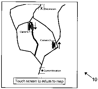
cameras on alternative possible routes. Figure 1 shows the map of the ttravel
area
displayed on the PND screen 10. Note that the position of the vehicle in which
the PND
is installed is indicated, as is the requested destination and the approximate
locations of
two static traffic cameras. The user touches the camera icon shown in the
screen to select
CA 02627784 2008-04-29
WO 2007/057696 PCT/GB2006/004314
18
caxnera 1. The PND downloads the appropriate image from the proxy server.
Figure 2
shows the image shown on the PND screen 20 from camera 1. By the direction of
the
arrow near to camera 1 in Figure 1, camera 1 is pointing in the opposite
direction to the
user's possible route past camera 1. This example is in the UK, where traffic
drives on
the left. Therefore because the image shows congestion on the side of the road
on which
the traffic is travelling in the opposite direction to the direction in which
the camera is
pointing, the user's possible route is suffering from congestion. This is in
contrast to the
traffic travelling in the direction in which the camera is pointing, which is
not suffering
from congestion. This example shows clearly the benefit of informing the user
of the
approximate direction in which the camera is pointing, as if the user did not
know in
wliich direction the camera was pointing, they would only have been able to
infer that
there was a 50:50 chance of encountering congestion near to catnera ,1. This
is a very
important benefit, as typically when congestion occurs, it occuxs for traffic
travelling in
one direction and not for traffic travelling in the opposite direction. The
arrow 21 in
Figure 2 shows that the camera taking the image is facing along the direction
which is
approximately opposite to that in which the user wishes to travel, because
this is the
meaning of an arrow which is pointing down. Another approach is for an arrow
to be
superimposed over the actual lanes that form part of the route; this may
require pattern
recognition software able to determine th.e edges of the road and to morph or
alter the
shape of an arrow so that it is shown in the correct orientation and
perspective as though
forming part of the road surface.
The driver returns to the map view of Figure 1 to investigate alternative
route options.
On viewing the image in Figu.re 1, the driver decides that the route passing
camera 2 may
be a good alternative. Figure 3 shows the image 30 displayed by the PND when
the
traffic camera 2 of Figure 1 is selected. The arrow 31 in Figure 3 shows that
the camera
taking the image is facing along the direction which is approximately parallel
to that in
which the user wishes to ttavel; because this is the meaning of an arrow which
is pointing
up. In Figure 3, because the direction in which the camera is pointing is
approximately
parallel to the intended journey direction, only one car is visible 'in the
lanes for the
direction in which the user wishes to travel. Based on the image in Figure 3,
this route
seems to be much less congested, so the driver decides to take the route past
camera 2.
At this point, the dtiver might ask the PND to calculate some routes. Amongst
the routes
CA 02627784 2008-04-29
WO 2007/057696 PCT/GB2006/004314
19
offered by the PND, the optimum route offered by the PND would depend upon
whether the routing system was aware of the delays at the camera 1 location,
and wlzat
account it made of them in route selection. But it is clear that where there
are cameras,
the traffic camera images have given tlie driver a good idea of the correct
route to take.
The driver may select a route which passes by camera 2, such as by including
the road by
camera 2 as an intermediate point in the route. This can be facilitated by
accoinpanying
each traffic camera image (or, more generally, each playback of audio or video
traffic
information), with route calculation options, such as a button labelled
'include in route'
and another button labelled 'exclude from route'. Touching the 'include in
route' button
then causes the route calculation algorithm (typically running on the PND
itsel~ to
calculate a route that goes past the traffic camera (or location otherwise
referenced in the
traffic information); touching the other button leads to a route being
calculated that
avoids that particular camera. The route calculation algorithm may,well use
other
kinds of traffic data in performing its calculations (e.g. road traffic
sensors, movement of
mobile telephones across the cell network etc.); hence, a typical PND may
display icons
indicative of roadworks, or major accidents super-iinposed over a navigation
map or a
schematic showing the planned route. It is well known that the quality of the
traffic
information can be very variable, not least because it comes from many
different sources.
Hence, it is not unknown for a major traffic jam to be completely unreported
by many
conventional traffic systems; with the present approach, a driver, seeing a
traffic jam
ahead, can ask his PND to display the POIs for all traffic cameras (this can
be done using
the standard POI selection process in which a user marks a check box for all
POI types
that are to be displayed). The PND then downloads the appropriate traffic
camera data
(which may be the most recent still image, or in some cases a real time video
feed) and
the driver can then select the traffic camera POI symbols for the cameras
along say the
next 5 miles of his route so that he has actual visual confirmation of what
the traffic jam
really looks like.
An image of a device 40 running an experimental system of the invention for
traffic
camera display 42 is shown in Figure 4. In Figure 4, the camera location is
indicated on a
map 41 together with an arrow which shows the approximate direction in which
the
camera is pointing. This is an example of how traffic camera images might look
on a real-
world PND. The white arrow 43 in Figure 4 shows that the camera taking the
image is
CA 02627784 2008-04-29
WO 2007/057696 PCT/GB2006/004314
facing along the direction which is approximately parallel to that in which
the user wishes
to travel, because this is the meaning of an arrow which is pointing up.
The device described above allows a variety of A/V information sources on a
5 communications network to be used to enhance the information provided by a
personal
navigation device. The mechanism for integrating the loading and viewing of
traffic
camera images with the route guidance and route selection facilities of a PND
is a
particular instance of this information enhancement. Other examples of A/V
information enhancement have also been outlined. The application of image and
video
10 compression techniques and the use of a proxy server allow the data to be
loaded onto
the PND in real time and in an efficient manner. Although the use of PNDs has
been
emphasized above, it will be appreciated by those skilled in the art that the
PND could
instead be an embedded automotive navigation device.
15 Various modifications and alterations of this invention will become
apparent to those
skilled in the art without departing from the scope of this invention, and it
should be
understood that this invention is not to be unduly liniited to the
illustrative embodiments.