Note: Descriptions are shown in the official language in which they were submitted.
CA 02635785 2008-06-30
WO 2007/079395 PCT/US2006/062682
DEVICE AND NETWORK ENABLED GEO-FENCING FOR
AREA SENSITIVE GAMING ENABLEMENT
CROSS REFERENCE
[0001] This application claims the benefit of U.S. Application No. 11/323,265,
filed December 30, 2005, entitled "Device and Network Enabled Geo-Fencing for
Area
Sensitive Gaming Enablement," which is hereby incorporated by reference in its
entirety.
TECHNICAL FIELD
[0002] The subject matter described herein relates generally to methods and
apparatus for locating wireless devices, and enabling, selectively enabling,
limiting,
denying, or delaying certain functions or services based on the calculated
geographic
location and a pre-set location area defined by local, regional, or national
legal
jurisdictions. Wireless devices, also called mobile stations (MS), include
those such as
used in analog or digital cellular systems, personal communications systems
(PCS),
enhanced specialized mobile radios (ESMRs), wide-area-networks (WANs), and
other
types of wireless communications systems. Affected functions or services can
include
those either local to the mobile station or performed on a landside server or
server
network. More particularly, but not exclusively, the subject matter described
herein
relates to the use of jurisdiction sensitive gaming, wagering, or betting laws
or
regulations to determine if the gaming functionality of a MS can be enabled.
-1-
CA 02635785 2008-06-30
WO 2007/079395 PCT/US2006/062682
BACKGROUND
[0003] This application is related by subject matter to U.S. Application No.
11/198,996 (attorney docket no. TPI-0693), filed August 8, 2005, entitled "Geo-
Fencing
in a Wireless Location System" (the entirety of which is hereby incorporated
by
reference), which is a continuation of U.S. Application No. 11/150,414, filed
June 10,
2005, entitled "Advanced Triggers for Location Based Service Applications in a
Wireless
Location System," which is a continuation-in-part of U. S. Application No.
10/768,587,
filed January 29, 2004, entitled "Monitoring of Call Information in a Wireless
Location
System," now pending, which is a continuation of U.S. Application No.
09/909,22 1, filed
July 18, 2001, entitled "Monitoring of Call Information in a Wireless Location
System,"
now U.S. Patent No. 6,782,264 B2, which is a continuation-in-part of U.S.
Application
No. 09/539,352, filed March 31, 2000, entitled "Centralized Database for a
Wireless
Location System," now U.S. Patent No. 6,317,604 Bl, which is a continuation of
U.S.
Application No. 09/227,764, filed January 8, 1999, entitled "Calibration for
Wireless
Location System," now U.S. Patent No. 6,184,829 Bl.
[0004] A great deal of effort has been directed to the location of wireless
devices, most notably in support of the Federal Communications Commission's
(FCC)
rules for Enhanced 911 (E91 1) Phase II. (The wireless Enhanced 911 (E91 1)
rules seek to
improve the effectiveness and reliability of wireless 911 service by providing
911
dispatchers with additional information on wireless 911 calls. The wireless
E911 program
is divided into two parts - Phase I and Phase II. Phase I requires carriers,
upon valid
request by a local Public Safety Answering Point (PSAP), to report the
telephone number
of a wireless 911 caller and the location of the antenna that received the
call. Phase II
requires wireless carriers to provide more precise location information,
within 50 to 300
meters in most cases. The deployment of E911 has required the development of
new
technologies and upgrades to loca1911 PSAPs, etc.) In E911 Phase II, the FCC's
mandate
included required location precision based on circular error probability.
Network-based
systems (wireless location systems where the radio signal is collected at the
network
receiver) were required to meet a precision of 67% of callers within 100
meters and 95%
of callers within 300 meters. Handset-based systems (wireless location systems
where the
radio signal is collected at the mobile station) were required to meet a
precision of 67%
of callers within 50 meters and 95% of callers within 100 meters. Wireless
carriers were
allowed to adjust location accuracy over service areas so the accuracy of any
given
location estimation could not be guaranteed.
-2-
CA 02635785 2008-06-30
WO 2007/079395 PCT/US2006/062682
[0005] While some considerations, such as accuracy and yield (the number of
successful locations per calls) were defined by the FCC for the single LBS
service of
E91 l, additional quality-of -service (QoS) parameters such as latency (time
to location
fix and delivery of the location estimate to the requesting or selected
application) were
not. The FCC concern with accuracy was for the particular instance of a
cellular call
being placed to an emergency services center (the 911 centers or PSAP). The
state-of-the-
art and the FCC's rigorous accuracy standards limited the technology choices
for widely
deployed location technologies. Network-based options for E911 Phase II
included
uplink-time-difference-of-arrival (U-TDOA), angle of arrival (AoA), and
TDOA/AoA
hybrids. Non- network-based location options for E911 Phase II included use of
the
Navistar Global Positioning System (GPS) augmented with data from a landside
server
that includes synchronization timing, orbital data (Ephemeris) and acquisition
data (code
phase and Doppler ranges).
[0006] Besides the FCC E911 compliant location systems for wireless voice
communications, other wireless location systems using Time-of-Arrival (TOA),
Time-
Difference-of-Arrival (TDOA), Angle-of-Arrival (AoA), Power-of-Arrival (POA),
Power-Difference-of-Arrival can be used to develop a location to meet specific
location-
based services (LBS) requirements.
[0007] In the Detailed Description section below, we provide further
background on location techniques and wireless communications systems that may
be
employed in connection with the present invention. In the remainder of this
Background
section, we provide further background on wireless location systems.
[0008] Early work relating to Wireless Location Systems is described in U.S.
Patent No. 5,327,144, July 5, 1994, "Cellular Telephone Location System,"
which
discloses a system for locating cellular telephones using time difference of
arrival
(TDOA) techniques. Further enhancements of the system disclosed in the '144
patent are
disclosed in U.S. Patent No. 5,608,410, March 4, 1997, "System for Locating a
Source of
Bursty Transmissions." Both of these patents are assigned to TruePosition,
Inc., the
assignee of the present invention. TruePosition has continued to develop
significant
enhancements to the original inventive concepts.
[0009] Over the past few years, the cellular industry has increased the number
of air interface protocols available for use by wireless telephones, increased
the number
of frequency bands in which wireless or mobile telephones may operate, and
expanded
the number of terms that refer or relate to mobile telephones to include
"personal
-3-
CA 02635785 2008-06-30
WO 2007/079395 PCT/US2006/062682
communications services," "wireless," and others. The air interface protocols
now used in
the wireless industry include AMPS, N-AMPS, TDMA, CDMA, GSM, TACS, ESMR,
GPRS, EDGE, UMTS WCDMA, and others.
[0010] The wireless communications industry has acknowledged the value and
importance of the Wireless Location System. In June 1996, the Federal
Communications
Commission issued requirements for the wireless communications industry to
deploy
location systems for use in locating wireless 911 callers. Widespread
deployment of these
systems can reduce emergency response time, save lives, and save enormous
costs
because of reduced use of emergency response resources. In addition, surveys
and studies
have concluded that various wireless applications, such as location sensitive
billing, fleet
management, and others, will have great commercial value in the coming years.
[0011] As mentioned, the wireless communications industry uses numerous air
interface protocols in different frequency bands, both in the U.S. and
internationally. In
general, neither the air interface nor the frequency bands impact the Wireless
Location
System's effectiveness at locating wireless telephones.
[0012] All air interface protocols use two categories of channels, where a
channel is defined as one of multiple transmission paths within a single link
between
points in a wireless network. A channel may be defined by frequency, by
bandwidth, by
synchronized time slots, by encoding, shift keying, modulation scheme, or by
any
combination of these parameters. The first category, called control or access
channel, is
used to convey information about the wireless telephone or transmitter, for
initiating or
terminating calls, or for transferring bursty data. For example, some types of
short
messaging services transfer data over the control channel. Different air
interfaces use
different terminology to describe control channels but the function of the
control channels
in each air interface is similar. The second category of channel, known as
voice or traffic
channel, typically conveys voice or data communications over the air
interface. Traffic
channels come into use once a call has been set up using the control channels.
Voice and
user data channels typically use dedicated resources, i.e., the channel can be
used only by
a single mobile device, whereas control channels use shared resources, i.e.,
the channel
can be accessed by multiple users. Voice channels generally do not carry
identifying
information about the wireless telephone or transmitter in the transmission.
For some
wireless location applications this distinction can make the use of control
channels more
cost effective than the use of voice channels, although for some applications
location on
the voice channel can be preferable.
-4-
CA 02635785 2008-06-30
WO 2007/079395 PCT/US2006/062682
[0013] The following paragraphs discuss some of the differences in the air
interface protocols:
[0014] AMPS - This is the original air interface protocol used for cellular
communications in the U.S. and described in TIA/EIA Standard IS 553A. The AMPS
system assigns separate dedicated channels for use by control channels (RCC),
which are
defined according to frequency and bandwidth and are used for transmission
from the
BTS to the mobile phone A reverse voice channel (RVC), used for transmission
from the
mobile phone to the BTS, may occupy any channel that is not assigned to a
control
channel.
[0015] N-AMPS - This air interface is an expansion of the AMPS air interface
protocol, and is defined in EIA/TIA standard IS-88. It uses substantially the
same control
channels as are used in AMPS but different voice channels with different
bandwidth and
modulation schemes.
[0016] TDMA - This interface, also known as D-AMPS and defined in
EIA/TIA standard IS-136, is characterized by the use of both frequency and
time
separation. Digital Control Channels (DCCH) are transmitted in bursts in
assigned
timeslots that may occur anywhere in the frequency band. Digital Traffic
Channels
(DTC) may occupy the same frequency assignments as DCCH channels but not the
same
timeslot assignment in a given frequency assignment. In the cellular band, a
carrier may
use both the AMPS and TDMA protocols, as long as the frequency assignments for
each
protocol are kept separated.
[0017] CDMA - This air interface, defined by EIA/TIA standard IS-95A, is
characterized by the use of both frequency and code separation. Because
adjacent cell
sites may use the same frequency sets, CDMA must operate under very careful
power
control, producing a situation known to those skilled in the art as the near-
far problem,
makes it difficult for most methods of wireless location to achieve an
accurate location
(but see U.S. Patent No. 6,047,192, Apri14, 2000, Robust, Efficient,
Localization
System, for a solution to this problem). Control channels (known in CDMA as
Access
Channels) and Traffic Channels may share the same frequency band but are
separated by
code.
[0018] GSM - This air interface, defined by the international standard Global
System for Mobile Communications, is characterized by the use of both
frequency and
time separation. GSM distinguishes between physical channels (the timeslot)
and logical
channels (the information carried by the physical channels). Several recurring
timeslots
-5-
CA 02635785 2008-06-30
WO 2007/079395 PCT/US2006/062682
on a carrier constitute a physical channel, which are used by different
logical channels to
transfer information - both user data and signaling.
[0019] Control channels (CCH), which include broadcast control channels
(BCCH), Common Control Channels (CCCH), and Dedicated Control Channels (DCCH),
are transmitted in bursts in assigned timeslots for use by CCH. CCH may be
assigned
anywhere in the frequency band. Traffic Channels (TCH) and CCH may occupy the
same
frequency assignments but not the same timeslot assignment in a given
frequency
assignment. CCH and TCH use the same modulation scheme, known as GMSK. The
GSM General Packet Radio Service (GPRS) and Enhanced Data rates for GSM
Evolution
(EDGE) systems reuse the GSM channel structure, but can use multiple
modulation
schemes and data compression to provide higher data throughput. GSM, GPRS, and
EDGE radio protocols are subsumed by the category known as GERAN or GSM Edge
Radio Access Network.
[0020] UMTS - Properly known as UTRAN (UMTS Terrestrial Radio Access
Network), is an air interface defined by the international standard third
Generation
Partnership program as a successor to the GERAN protocols. UMTS is also
sometimes
known as WCDMA (or W-CDMA), which stands for Wideband Code Division Multiple
Access. WCDMA is direct spread technology, which means that it will spread its
transmissions over a wide, 5MHz carrier.
[0021] The WCDMA FDD (Frequency Division Duplexed) UMTS air interface
(the U- interface) separates physical channels by both frequency and code. The
WCDMA
TDD (Time Division Duplexed) UMTS air interface separates physical channels by
the
use of frequency, time, and code. All variants of the UMTS radio interface
contain
logical channels that are mapped to transport channels, which are again mapped
to W-
CDMA FDD or TDD physical channels. Because adjacent cell sites may use the
same
frequency sets, WCDMA also uses very careful power control to counter the near-
far
problem common to all CDMA systems. Control channels in UMTS are known as
Access
Channels whereas data or voice channels are known as Traffic Channels. Access
and
Traffic Channels may share the same frequency band and modulation scheme but
are
separated by code. Within this specification, a general reference to control
and access
channels, or voice and data channels, shall refer to all types of control or
voice and data
channels, whatever the preferred terminology for a particular air interface.
Moreover,
given the many types of air interfaces (e.g., IS-95 CDMA, CDMA 2000, UMTS, and
W-
CDMA) used throughout the world, this specification does not exclude any air
interface
-6-
CA 02635785 2008-06-30
WO 2007/079395 PCT/US2006/062682
from the inventive concepts described herein. Those skilled in the art will
recognize other
interfaces used elsewhere are derivatives of or similar in class to those
described above.
[0022] GSM networks present a number of potential problems to existing
Wireless Location Systems. First, wireless devices connected to a
GSM/GPRS/UMTS
network rarely transmit when the traffic channels are in use. The use of
encryption on the
traffic channel and the use of temporary nicknames (Temporary Mobile Station
Identifiers (TMSI)) for security render radio network monitors of limited
usefulness for
triggering or tasking wireless location systems. Wireless devices connected to
such a
GSM/GPRS/UMTS radio network merely periodically "listen" for a transmission to
the
wireless device and do not transmit signals to regional receivers except
during call setup,
voice/data operation, and call breakdown. This reduces the probability of
detecting a
wireless device connected to a GSM network. It may be possible to overcome
this
limitation by actively "pinging" all wireless devices in a region. However,
this method
places large stresses on the capacity of the wireless network. In addition,
active pinging
of wireless devices may alert mobile device users to the use of the location
system, which
can reduce the effectiveness or increase the annoyance of a polling location-
based
application.
[0023] The above-cited Application No. 11/198,996, "Geo-Fencing in a
Wireless Location System," describes methods and systems employed by a
wireless
location system to locate a wireless device operating in a defined geographic
area served
by a wireless communications system. In such a system, a geo-fenced area may
be
defined, and then a set of predefined signaling links of the wireless
communications
system may be monitored. The monitoring may also include detecting that a
mobile
device has performed any of the following acts with respect to the geo-fenced
area: (1)
entered the geo-fenced area, (2) exited the geo-fenced area, and (3) come
within a
predefined degree of proximity near the geo-fenced area. In addition, the
method may
also include, in response to detecting that the mobile device has performed at
least one of
these acts, triggering a high-accuracy location function for determining the
geographic
location of the mobile device. The present application describes methods and
systems for
using the concept of a geo-fenced area to enable, selectively enable, limit,
deny, or delay
certain functions or services based on the calculated geographic location and
a pre-set
location area defined by local, regional, or national legal jurisdictions. The
present
invention, however, is by no means limited to systems employing the geo-
fencing
technologies described in the above-cited Application No. 11/198,996.
-7-
CA 02635785 2008-06-30
WO 2007/079395 PCT/US2006/062682
SUMMARY
[0024] The following summary provides an overview of various aspects of
exemplary implementations of the invention. This summary is not intended to
provide an
exhaustive description of all of the important aspects of the invention, or to
define the
scope of the invention. Rather, this summary is intended to serve as an
introduction to the
following description of illustrative embodiments.
[0025] With the increase in gaming and the increase in wireless networks,
interest in wireless device-based gaming is rising. In the present
application, we describe,
among other things, a wireless user interface device, application server, and
location
service to enable legal wireless gaming. The ability to independently locate
the wireless
device serves to eliminate location spoofing and assures authorities that the
gaming
transaction is limited to licensed jurisdictions.
[0026] The illustrative embodiments described herein provide methods and
apparatus for locating wireless devices, and enabling, selectively enabling,
limiting,
denying, or delaying certain functions or services based on the calculated
geographic
location and a pre-set location area defined by user definitions; service
area; billing
zones; or local, regional, or national political boundaries or legal
jurisdictions. Wireless
devices include those such as used in analog or digital cellular systems,
personal
communications systems (PCS), enhanced specialized mobile radios (ESMRs), wide-
area-networks (WANs), networks of localized radios (WiFi, UWB, RFID) and other
types of wireless communications systems. Affected functions or services can
include
those either local to the wireless device or performed on a server or server
network. More
particularly, but not exclusively, we describe the use of wireless device
location estimates
with jurisdiction sensitive gaming, wagering, or betting laws or regulations
to determine
if the gaming functionality of a wireless device can be enabled.
[0027] Additional features and advantages of the invention will be made
apparent from the following Detailed Description of Illustrative Embodiments.
BRIEF DESCRIPTION OF THE DRAWINGS
[0028] The foregoing summary as well as the following detailed description are
better understood when read in conjunction with the appended drawings. For the
purpose
of illustrating the invention, there is shown in the drawings exemplary
constructions of
the invention; however, the invention is not limited to the specific methods
and
instrumentalities disclosed. In the drawings:
-8-
CA 02635785 2008-06-30
WO 2007/079395 PCT/US2006/062682
[0029] Figure 1 schematically depicts a Location Device Platform (LDP) Client
Device.
[0030] Figure 2 schematically depicts an LDP Server.
[0031] Figure 3 schematically depicts a system in accordance with the present
invention.
[0032] Figure 4 is a flowchart illustrating a process in accordance with the
present invention.
DETAILED DESCRIPTION OF ILLUSTRATIVE EMBODIMENTS
A. Overview
[0033] A Location Device Platform (LDP) Client 110 and LDP Server 220 (see
Figs. 1 and 2, respectively) enable location services for any physical item.
In one mode,
the item is or comprises wireless communications device (cell phone, PDA,
etc.)
configured for the purposes of wagering. Since wagering is controlled (in the
USA) by
local or state regulations, the location of legal wagering is typically
confined to enclosed
areas such as casinos, riverboats, parimutuel tracks, or assigned off-site
locations. Use of
the LPD capabilities allows for wagering to take place anywhere under the
control of a
regulatory body.
[0034] The LDP Client Device 110 may be used for both purpose-built and
general purpose computing platforms with wireless connections and wagering
functionality. The LDP Server 220, a location-aware server resident in a
telecommunications network, can perform location checking on the wireless LDP
Client
Device 110 (analogous to existing systems checking of IP addresses or
telephony area
codes) to determine if wagering functionality can be enabled. The actual
wagering
application can be resident on the LDP Server 220 or exist on another
networked server.
The LDP Server 220 can even supply a gaming permission indicator or a
geographical
location to a live operator/teller.
[0035] The location methodology employed by the wireless location system
may be dependent on the service area deployed or requirements from the
wagering entity
or regulatory authority. Network-based location systems include those using
POA,
PDOA, TOA, TDOA, or AOA, or combinations of these. Device-based location
systems
may include those using POA, PDOA, TOA, TDOA, GPS, or A-GPS. Hybrids,
combining multiple network-based techniques, multiple device-based techniques,
or a
combination of network and device based techniques, can be used to achieve the
accuracy, yield, and latency requirements of the service area or location-
based service.
-9-
CA 02635785 2008-06-30
WO 2007/079395 PCT/US2006/062682
The location-aware LDP Server 220 may decide on the location technique to use
from
those available based on cost of location acquisition.
[0036] The LDP Client Device 110 preferably includes a radio communications
link (radio receiver and transmitter 100, 101) for communicating with the LDP
Server
220. Wireless data communications may include cellular (modem, CPDP, EVDO,
GPRS,
etc.) or wide-area networks (WiFi, WiMAN/MAX, WiBro, ZigBee, etc.) associated
with
the location system. The radio communications method can be independent of the
wireless location system functionality - for instance, the device may acquire
a local WiFi
Access Point, but then use GSM to communicate the SSID of the WiFi beacon to
the
LDP Server 220 for a proximity location.
[0037] The LDP Server 220 authenticates, authorizes, bills, and administers
the
use of the LDP Client Device 110. Preferably, the LDP Server 220 also
maintains the
service area definitions and wagering rules associated with each service area.
The service
area may be either a polygon defined by a set of latitude/longitude points or
a radius from
a central point. The service area may be defined within the location-aware
server by
interpretation of gaming statutes. Based on the service area definition, the
rules, and the
calculated location, the LDP Server 220 may grant the wireless device full
access, limited
access, or no access to gaming services. The LDP Server 220 also preferably
supports a
geo-fencing application where the LDP Client Device 110 (and the wagering
server) is
informed when the LDP Client Device 110 enters or leaves a service area. The
LDP
Server 220 preferably supports multiple limited access indications. Limited
access to a
wagering service can mean that only simulated play is enabled. Limited access
to service
can also mean that real multi-player gaming is enabled, but wagering is not
allowed.
Limited access to service may be determined by time of day or by the location
combined
with the time of day. Moreover, limited access to service can mean that a
reservation for
gaming at a particular time and within a prescribed area is made.
[0038] The LDP Server 220 can issues a denial of service to both the LDP
Client Device 110 and the wagering server. Denial of access can also allow for
the
provision of directions to where requested gaming is allowed.
[0039] The LDP Client Device 110 and LDP Server 220 may allow for all
online gaming and wagering activities based on card games, table games, board
games,
horse racing, auto racing, athletic sports, on-line RPG, and online first
person shooter.
-10-
CA 02635785 2008-06-30
WO 2007/079395 PCT/US2006/062682
[0040] It is envisioned, but not required, that the LDP Server 220 could be
owned or controlled by a wireless carrier, a gaming organization or a local
regulatory
board.
[0041] We will now briefly summarize two exemplary use cases.
Use Case: Geo-fencin
[0042] In this scenario, the LDP Client Device 110 is a purpose-built gaming
model using GSM as the radio link and network-based Uplink-TDOA as the
location
technique. Handed out to passengers as they arrive at the airport, the LDP
Client Device
110 initially supports gaming tutorials, advertisements, and simulated play.
When the
device enters the service area, it signals the user though audible and visual
indicators that
the device is now capable of actual wagering. This is an example of a geo-
fencing
application. Billing and winnings are enabled via credit card or can be
charged/awarded
to a hotel room number. If the LDP Client Device 1101eaves the area, audible
and visual
indicators show that the device is now incapable of actual wagering as the LPD
Server
220 issues a denial message to the LDP Client Device and wagering server.
Use Case: Access Attempt
[0043] In this scenario, the LDP Client Device 110 is a general purpose
portable
computer with a WiFi transceiver. A wagering application client is resident on
the
computer. Each time a wagering function is accessed, the LDP Client Device 110
queries
the LDP Server 220 for permission. The LDP Server 220 obtains the current
location
based on the WiFi SSID and power of arrival, compares the location against the
service
area definition and allows or denies access to the selected wagering
application. Billing
and winnings are enabled via credit card.
B. LDP Client Device
[0044] The LDP Client Device 110 is preferably implemented as a location
enabling hardware and software electronic platform. The LDP Client Device 110
is
preferably capable of enhancing accuracy of a network-based wireless location
system
and hosting both device-based and hybrid (device and network-based) wireless
location
applications.
Form Factors
[0045] The LDP Client Device 110 may be built in a number of form-factors
including a circuit-board design for incorporation into other electronic
systems. Addition
(or deletion) of components from the Radio Communications
Transmitter/Receiver,
-11-
CA 02635785 2008-06-30
WO 2007/079395 PCT/US2006/062682
Location Determination, Display(s), Non-Volatile Local Record Storage,
Processing
Engine, User Input(s), Volatile Local Memory, Device Power Conversion and
Control
subsystems or removal of unnecessary subsystems allow the size, weight, power,
and
form of the LPD to match multiple requirements.
Radio Communications - Transmitter 101
[0046] The LDP Radio Communications subsystem may contain one or more
transmitters in the form of solid-state application-specific-integrated-
circuits (ASICs).
Use of a software defined radio may be used to replace multiple narrow-band
transmitters
and enable transmission in the aforementioned radio communications and
location
systems. The LDP Client Device 110 is capable of separating the communications
radio
link transmitter from the transmitter involved in a wireless location
transmission under
direction of the onboard processor or LDP Server 220.
Radio Communications - Receiver 100
[0047] The LDP Radio Communications subsystem may contain one or more
receivers in the form of solid-state application-specific-integrated-circuits
(ASICs). Use
of a wide-band software defined radio may be used to replace multiple narrow-
band
receivers and enable reception of the aforementioned radio communications and
location
systems. The LDP Client Device 110 is capable of separating the communications
radio
link receiver from the receiver used for wireless location purposes under
direction of the
onboard processor or LDP Server 220. The LDP Radio Communications subsystem
may
also be used to obtain location-specific broadcast information (such as
transmitter
locations or satellite ephemerides) or timing signals from the communications
network or
other transmitters.
Location Determination Enine 102
[0048] The Location Determination Engine, or subsystem, 102 of the LPD
Client Device enables device-based, network-based, and hybrid location
technologies.
This subsystem can collect power and timing measurements, broadcast
positioning
information and other collateral information for various location
methodologies,
including but not limited to: device-based time-of-arrival (TOA), forward link
trilateration (FLT), Advanced-forward-link-trilateration (AFLT), Enhanced-
forward-link-
trilateration (E-FLT), Enhanced Observed Difference of Arrival (EOTD),
Observed Time
Difference of Arrival (O-TDOA), Global Positioning System (GPS) and Assisted
GPS
(A-GPS). The location methodology may be dependent on the characteristics of
the
-12-
CA 02635785 2008-06-30
WO 2007/079395 PCT/US2006/062682
underlying radio communications or radio location system selected by the LDP
or LDP
Server 220.
[0049] The Location Determination subsystem can also act to enhance location
in network-based location systems by modifying the transmission
characteristics of the
LPD Client Device 110 to maximize the device's signal power, duration,
bandwidth,
and/or delectability (for instance, by inserting a known pattern in the
transmitted signal to
enable the network-based receiver to use maximum likelihood sequence
detection).
Display(s) 103
[0050] The display subsystem of the LDP Client Device, when present, may be
unique to the LDP and optimized for the particular location-application the
device
enables. The display subsystem may also be an interface to another device's
display
subsystem. Examples of LDP displays may include sonic, tactile or visual
indicators.
User Input(s) 104
[0051] The User Input(s) subsystem 104 of the LDP Client Device, when
present, may be unique to the LDP Client Device and optimized for the
particular
location-application the LPD Client Device enables. The User Input subsystem
may also
be an interface to another device's input devices.
Timer 105
[0052] The timer 105 provides accurate timing/clock signals as may be required
by the LDP Client Device 110.
Device Power Conversion and Control 106
[0053] The Device Power Conversion and Control subsystem 106 acts to
convert and condition landline or battery power for the other LDP Client's
electronic
subsystems.
Processing Engine 107
[0054] The processing engine subsystem 107 may be a general purpose
computer that can be used by the radio communication, displays, inputs, and
location
determination subsystems. The processing engine manages LDP Client resources
and
routes data between subsystems and to optimize system performance and power
consumption in addition to the normal CPU duties of volatile/non-volatile
memory
allocation, prioritization, event scheduling, queue management, interrupt
management,
paging/swap space allocation of volatile memory, process resource limits,
virtual memory
management parameters, and input/output (I/O) management. If a location
services
-13-
CA 02635785 2008-06-30
WO 2007/079395 PCT/US2006/062682
application is running local to the LDP Client Device 110, the processing
engine
subsystem 107 can be scaled to provide sufficient CPU resources.
Volatile Local Memory 108
[0055] The Volatile Local Memory subsystem 108 is under control of the
processing engine subsystem 107, which allocates memory to the various
subsystems and
LDP Client resident location applications.
Non-Volatile Local Record Stora4e 109
[0056] The LDP Client Device 110 may maintain local storage of transmitter
locations, receiver locations or satellite ephemerides in non-volatile local
record storage
109 through power-down conditions. If the location services application is
running local
to the LDP Client, application specific data and application parameters such
as
identification, ciphering codes, presentation options, high scores, previous
locations,
pseudonyms, buddy lists, and default settings can be stored in the non-
volatile local
record storage subsystem.
C. Location Aware Application Enabling Server (LDP Server) 220
[0057] The LDP Server 220 (see Fig. 2) provides the interface between the
wireless LDP Client Devices 110 and networked location-based services
applications. In
the following paragraphs we describe the components of the illustrative
embodiment
depicted in Figure 2. It should be noted that the various functions described
are
illustrative and are preferably implemented using computer hardware and
software
technologies, i.e., the LDP Server is preferably implemented as a programmed
computer
interfaced with radio communications technologies.
Radio Communications Network Interface 200
[0058] The LDP Server 220 connects to the LDP Client Device 110 by a data
link running over a radio communications network either as a modem signal
using
systems such as, but not limited to: CDPD, GPRS, SMS/MMS, CDMA-EVDO, or
Mobitex. The Radio Communications Network Interface (RCNI) subsystem acts to
select
and commands the correct (for the particular LDP) communications system for a
push
operation (where data is sent to the LDP Client 110). The RCNI subsystem also
handles
pull operations where the LDP Client Device 110 connects the LDP Server 220 to
initiate
a location or location-sensitive operation.
-14-
CA 02635785 2008-06-30
WO 2007/079395 PCT/US2006/062682
Location Determination Enine 201
[0059] The Location Determination Engine subsystem 201 allows the LDP
Server 220 to obtain LDP Client Device 110 location via network-based TOA,
TDOA,
POA, PDOA, AoA or hybrid device and network-based location techniques.
Administration Subsystem 202
[0060] The Administration subsystem 202 maintains individual LDP records
and services subscription elections. The LDP Server 220 Administration
subsystem
allows for arbitrary groupings of LDP Client Devices to form services classes.
LDP
subscriber records may include ownership; passwords/ciphers; account
permissions; LDP
Client Device 110 capabilities; LDP make, model, and manufacturer; access
credentials;
and routing information. In the case where the LDP Client Device is a
registered device
under a wireless communication provider's network, the LDP Server 220
administration
subsystem preferably maintains all relevant parameters allowing for LDP access
of the
wireless communication provider's network.
Accounting Subsystem 203
[0061] The LDP Accounting subsystem 203 handles basic accounting functions
including maintaining access records, access times, and the location
application accessing
the LDP Client location allowing for charging for individual LDP Client Device
and
individual LBS services. The Accounting subsystem also preferably records and
tracks
the cost of each LDP access by the wireless communications network provider
and the
wireless location network provider. Costs may be recorded for each access and
location.
The LDP Server 220 can be set with a rules-based system for the minimization
of access
charges via network and location system preference selection.
Authentication Subsystem 204
[0062] The main function of the Authentication subsystem 204 is to provide the
LDP Server 220 with the real-time authentication factors needed by the
authentication
and ciphering processes used within the LDP network for LDP access, data
transmission
and LBS-application access. The purpose of the authentication process is to
protect the
LDP network by denying access by unauthorized LDP Clients or by location-
applications
to the LDP network and to ensure that confidentiality is maintained during
transport over
a wireless carrier's network and wireline networks.
Authorization Subsystem 205
[0063] The Authorization subsystem 205 uses data from the Administration and
Authentication subsystems to enforce access controls upon both LDP Client
Devices and
-15-
CA 02635785 2008-06-30
WO 2007/079395 PCT/US2006/062682
Location-based applications. The access controls implemented may be those
specified in
Internet Engineering Task Force (IETF) Request for Comment RFC-3693, "Geopriv
Requirements," the Liberty Alliance's Identity Service Interface
Specifications (ID-SIS)
for Geo-location, and the Open Mobile Alliance (OMA). The Authorization
subsystem
may also obtain location data for an LDP Client before allowing or preventing
access to a
particular service or Location-based application. Authorization may also be
calendar or
clock based dependent on the services described in the LDP profile record
resident in the
administration subsystem. The Authorization system may also govern connections
to
external billing system and networks, denying connections to those networks
that are not
authorized or cannot be authenticated.
Non-Volatile Local Record Stora4e 206
[0064] The Non-Volatile Local Record Storage of the LDP Server 220 is
primarily used by the Administration, Accounting, and Authentication
subsystems to
store LDP profile records, ciphering keys, WLS deployments, and wireless
carrier
information.
Processin Enine 207
[0065] The processing engine subsystem 207 may be a general purpose
computer. The processing engine manages LDP Server resources and routes data
between
subsystems.
Volatile Local Memory 208
[0066] The LDP Server 220 has a Volatile Local Memory store composed of
multi-port memory to allow the LDP Server 220 to scale with multiple,
redundant
processors.
External Billin Network(s) 209
[0067] Authorized External billing networks and billing mediation system may
access the LDP accounting subsystem database through this subsystem. Records
may also
be sent periodically via a pre-arranged interface.
Interconnection(s) to External Data Network(s) 210
[0068] The interconnection to External Data networks is designed to handle
conversion of the LDP data stream to external LBS applications. The
interconnection to
External Data networks is also a firewall to prevent unauthorized access as
described in
the Internet Engineering Task Force (IETF) Request for Comment RFC-3694,
"Threat
Analysis of the Geopriv Protocol." Multiple access points resident in the
Interconnection
to External Data Networks subsystem 210 allow for redundancy and
reconfiguration in
-16-
CA 02635785 2008-06-30
WO 2007/079395 PCT/US2006/062682
the case of a denial-of-service or loss of service event. Examples of
interconnection
protocols supported by the LDP Server 220 include the Open Mobile Alliance
(OMA)
Mobile-Location-Protocol (MLP) and the Parlay X specification for web
services; Part 9:
Terminal Location as Open Service Access (OSA); Parlay X web services; Part 9:
Terminal location (also standardized as 3GPP TS 29.199-09).
External Communications Network(s) 211
[0069] External Communications Networks refer to those networks, both public
and private, used by the LDP Server 220 to communicate with location-based
applications not resident on the LDP Server 220 or on the LDP Client Device
110.
D. System/Process for Gaming
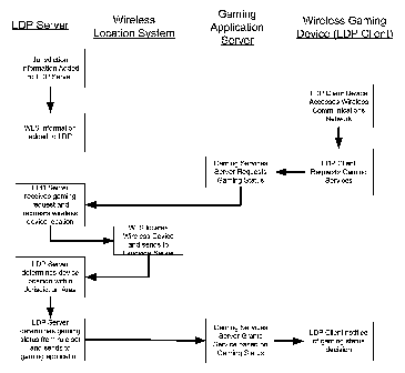
[0070] Figure 3 illustrates a system in accordance with one embodiment of the
present invention. As shown, such a system includes one or more LDP Client
Devices
110 and an LDP Server 220. The LDP Client Devices 110 may be configured for
gaming
applications of the type that are typically regulated by state and local
governmental
agencies. As discussed above, an LDP Client Device may comprise a conventional
mobile computing device (e.g., PDA), a mobile digital phone, etc., or may be a
special
purpose device dedicated to gaming. The LDP Client Device 110 has the
capability to
provide a user with wireless access to an Internet-based gaming application
server. Such
access may be provided via a wireless communications network (cellular, WiFi,
etc.), as
shown. In this implementation of the system, the gaming application server
includes or is
coupled to a database of gaming information, such as information describing
the
geographic regions where wagering is permitted.
[0071] As shown in Figure 3, the LDP Server 220 and Gaming Application
Server are operatively coupled by a communications link, so that the two
devices may
communicate with one another. In this embodiment, the LDP Server 220 is also
operatively coupled to a wireless location system, which, as discussed herein,
may be any
kind of system for determining the geographic location of the LDP Client
Devices 110. It
is not necessary that the LDP Client Devices be located with the precision
required for
emergency (e.g., E911) services, but only that they be located to the extent
necessary to
determine whether the devices are in an area where wagering is permitted.
[0072] Referring now to Figure 4, in one exemplary implementation of the
invention, the LDP Server is provided with gaming jurisdictional information
and well as
information provided by the wireless location system. The precise details of
what
-17-
CA 02635785 2008-06-30
WO 2007/079395 PCT/US2006/062682
information is provided to the LDP Server will depend upon the precise details
of what
kinds of services the LDP Server is to provide.
[0073] As shown in Figure 4, the LDP Client Device accesses the wireless
communications network and requests access to gaming services. This request is
routed
to the gaming application server, and the gaming application server in turn
requests
location information from the LDP Server. The LDP Server requests the WLS to
locate
the LDP Client Device, and the WLS returns the location information to the LDP
Server.
In this implementation of the invention, the LDP Server determines that the
LDP Client
Device is within a certain predefined jurisdictional area, and then determines
whether
gaming/wagering services should be provided (alternatively, this determination
could be
made the responsibility of the gaming application server). This information is
provided to
the gaming application server, and the gaming application server notifies the
LDP Client
Device of the determined gaming status decision (i.e., whether gaming services
will or
will not be provided).
E. Other Embodiments
LDP power savings through selective awake mode
[0074] Wireless devices typically have three modes of operation to save
battery
life: sleep, awake (listen), and transmit. In the case of the LDP Client
Device 110, a
fourth state, locate, is possible. In this state, the LDP Client Device 110
comes first to the
awake state. From received data or external sensor input, the LPD Client
determines if
activation of the Location Determination Engine or Transmission subsystem is
required.
If the received data or external sensor input indicates a location
transmission is not
needed, then the LDP Client Device 110 powers neither the location
determination or
transmission subsystems and returns to the minimal power drain sleep mode. If
the
received data or external sensor input indicates a location transmission is
needed only if
the device position has changed, then the LDP Client Device 110 will perform a
device-
based location and returns to the minimal power drain sleep mode. If the
received data or
external sensor input indicates a location transmission is necessary, then the
LDP Client
Device 110 may perform a device-based location determination, activate the
transmitter,
send the current LDP Client Device 1101ocation (and any other requested data)
and
return to the minimal power drain sleep mode. Alternatively, if the received
data or
external sensor input indicates a location transmission is necessary, then the
LDP Client
Device 110 may activate the transmitter, send a signal (optimized for
location) to be
-18-
CA 02635785 2008-06-30
WO 2007/079395 PCT/US2006/062682
located by network-means (the LDP Client Device 110 may send any other
requested
data at this time) and then return to the minimal power drain sleep mode.
Invisible Roamin for non-voice wireless LDPs
[0075] For LDP Clients using cellular data communications, it is possible to
provision the LDP Clients for minimal impact to existing cellular
authentication,
administration, authorization and accounting services. In this scenario, a
single LDP
platform is distributed in each cellular base station footprint (within the
cell-site
electronics). This single LDP Client Device 110 is then registered normally
with the
wireless carrier. All other LDPs in the area would then use SMS messages for
communication with the LDP Server 220 (which has its own authentication,
administration, authorization and accounting services) based on the single LDP
ID
(MIN/ESN/IMSI/TMSI) to limit HLR impact. A server would use the payload of the
SMS to determine both the true identity of the LDP and also the triggering
action,
location or attached sensor data.
SMS location probes using a known pattern loaded into the LDP
[0076] Using SMS messages with a known pattern of up to 190 characters in a
deployed WLS control channel location architecture or A-bis monitored system
the LDP
Client Device 110 can enhance the location of an SMS transmission. Since
characters are
known, the encryption algorithm is known, the bit pattern can be generated and
the
complete SMS message is available for use as an ideal reference by signal
processing to
remove co-channel interference and noise to increase the precision possible in
a location
estimation.
Location Data EncryMtion for Privacy, distribution and non-repudiation.
[0077] A method for enforcement of privacy, re-distribution and billing non-
repudiation using an encryption key server based in the LDP Server 220 may be
employed. In this method, the LDP Server 220 would encrypt the location record
before
delivery to any outside entity (the master gateway). The gateway can either
open the
record or pass the protected record to another entity. Regardless of the
opening entity, a
key would have to be requested from the LDP Server 220 key server. The request
for this
key (for the particular message sent) means that the "private" key "envelope'
was opened
and the location sequence number (a random number allocated by the LDP Server
220 to
identify the location record) read by the entity. The LDP Server 220 would
then deliver a
"secret" key and the subscriber's location under the same "private" key
repeating the
location sequence number to allow reading of the location record. In this
manner
-19-
CA 02635785 2008-06-30
WO 2007/079395 PCT/US2006/062682
subscriber privacy is enforced, gateways can redistribute location records
without reading
and recording the data, and receipt of the record by the final entity is non-
reputable.
Overlay Network-based location enhancement via LDP data channel
[0078] To perform an enhanced network-based location, the LDP Client Device
110 may be configured to receive broadcast acquisition data, register on the
system (if
required) and request data service from the wireless network. The data
connection is
routed by the data network to the LDP Server 220. Upon connection with the LDP
Server
220, the LDP Client Device 110 then immediately transmits its ID (examples
include:
MIN/ESN/TMSI/TruePosition), its channel information (examples include:
Channel, CC,
etc); its neighbor (for instance, the mobile-assisted-handoff (MAHO) list
(containing the
target network station, target channel, target time offset, power offset,
etc.); any
encryption bit-string given to the LDP Client Device 110 by the network, and a
semi
random-but-known pattern to send over the existing data path. This semi-random
sequence is retransmitted on a (n) second repeat period (the (n) second repeat
can be
matched to the availability of the MAHO list) until commanded to stop either
by internal
counters/timers or by the LDP Server 220.
[0079] The LDP Server 220 selects the network receiver stations based on the
received channels and receiver stations available in the neighbor (MAHO) list
(if any) or
from internal tables of stations locations. The network-based wireless
location then
performs a location up to the threshold of accuracy required by the quality of
service
demanded.
[0080] The LDP Server 220 can use the established duplex data path with the
LDP Client Device 110 to update the LDP timers, ID, programming, or other
characteristics. The LDP Server 220 can then command the LDP Client Device 110
based
on location, Ce11ID, mode, band, or RF protocol. The cellular system
signaling, voice,
and/or data encryption is irrelevant to this application since that data can
be delivered in
the data path to the WLS for use.
LDP location with only a network-based wireless location s, s~
[0081] An LDP Client Device 110 not equipped with a device-based location
determination engine can report its position in a non-network-based WLS
environment to
a LDP Server 220 equipped with an SMSC. At the highest level, the LDP Client
Device
110 can report the System ID (SID or PLMN) number or Private System ID (PSID)
so
the WLS can make the determination that the LPD is in (or out) of a WLS
equipped
system. The neighbor (MAHO) list transmitted as a series of SMS messages on
the
-20-
CA 02635785 2008-06-30
WO 2007/079395 PCT/US2006/062682
control channel could give rough location in a friendly carrier network that
has not yet
been equipped with a WLS. Reverse SMS allows for the WLS to reprogram any
aspect of
the LDP. If the LDP Client Device 110 is in a network-based WLS equipped area,
the
LDP Client Device 110 can then offer higher levels of accuracy using the
network-based
WLS.
Automatic transmitter location via LDP with network database
[0082] If the LDP Client Device 110 radio communications subsystem is
designed for multi-frequency, multi-mode operation or if the LDP Client Device
110 is
provided with connection to external receivers or sensors, the LDP Client
Device 110
becomes a location-enabled telemetry device. In a particular application, the
LDP Client
Device 110 uses the radio communications subsystem or external receiver to
locate radio
broadcasts. Reception of such broadcasts, identified by the transmission band
or
information available from the broadcast, triggers the LDP Client Device 110
to establish
a data connection to the LDP Server 220, perform a device-based location or
begin a
location-enhanced transmission for use by the LDP Server 220 or other network-
based
server.
[0083] One exemplary use of this LDP Client Device 110 variant is as a
networked radar detector for automobiles or as a WiFi hotspot locator. In
either case, the
LDP Server 220 would record the network information and location for delivery
to
external location-enabled applications.
Use of externally derived precision timing for scheduling communications
[0084] Battery life may be a key enabler for at least some applications of
autonomous location specific devices. In addition, the effort associated with
periodically
charging or replacing batteries in a location specific device is anticipated
to be a
significant cost driver. A device is considered to have 3 states: active,
idle, sleep.
Active = in communication with the network
Idle = in a state capable of entering the active state
Sleep = a low power state
[0085] The power consumption in the active state is driven by the efficiency
of
digital and RF electronics. Both of these technologies are considered mature
and their
power consumption is considered to be already optimized. The power consumption
in the
sleep mode is driven by the amount of circuitry active during the sleep state.
Less
circuitry means less power consumption. One method of minimizing power
consumption
is to minimize the amount of time spent in the idle state. During the idle
state, the device
-21 -
CA 02635785 2008-06-30
WO 2007/079395 PCT/US2006/062682
must periodically listen to the network for commands (paging) and if received
enter the
active state. In a standard mobile station (MS), the amount of time spent in
the idle state
is minimized by restricting the when the paging commands can occur for any
particular
mobile station.
[0086] This aspect of the invention utilizes an absolute external time
reference
(GPS, A-GPS, or information broadcast over a cellular network) to precisely
calibrate the
location specific client device's internal time reference. An internal
temperature sensing
device would enable the device to temperature compensate its own reference.
The GPS or
A-GPS receiver can be part of the location determination engine of the LDP
Client
Device 110 used for device-based location estimation.
[0087] Given that the location specific device has a precise time reference,
the
network can schedule the device to enter the idle mode at a precise time
thereby
maximizing the amount of time spent in the lowest power state. This method
will also
minimize unsuccessful attempts to communicate with a device in sleep mode
thereby
minimizing load on the communication network.
Speed, Time, Altitude, Area Service
[0088] The LDP Client Device functionality may be incorporated into other
electronic devices. As such, the LDP, a location-aware device with radio
communications
to an external server with a database of service parameters and rules for use,
can be used
to grant, limit or deny service on the basis of not only location within a
service area, but
also on the basis of time, velocity, or altitude for a variety of electronic
devices such as
cell phones, PDAs, radar detectors, or other interactive systems. Time
includes both time-
of-day and also periods of time so duration of a service can be limited.
Intelli~4ent Mobile Proximity
[0089] The LDP Client Device 110 may be paired with another LDP Client to
provide intelligent proximity services where the granting, limiting, or denial
of services
can be based on the proximity of the LDP pair. For instance, in an anti-theft
application,
an LDP Client Device 110 could be incorporated into an automobile while other
LDPs
would be incorporated into the car radio, navigation system, etc. By
registering the set of
LDP Clients as paired in the LDP Server 220, and setting triggering conditions
for
location determination based on activation or removal, an anti-theft system is
created. In
the case of unauthorized removal, the LDP Client Device 110 in the removed
device
could either deny service or allow service while providing location of the
stolen device
incorporating the LDP Client.
-22-
CA 02635785 2008-06-30
WO 2007/079395 PCT/US2006/062682
F. Location Techniques: Network-Based, Device-Based and Hybrid
[0090] Each wireless (radio) location system comprises a transmitter and
receiver. The transmitter creates the signal of interest [s(t)], which is
collected and
measured by the receiver. The measurement of the signal of interest may take
place at
either the wireless device or the network station. The transmitter or the
receiver can be in
motion during the signal measurement interval. Both may be in motion if the
movements
of either (or both) can be precisely defined a priori.
Network-Based Location Techniques
[0091] When the measurement takes place at the network (a geographically
distributed set of one or more receivers or transceivers), the location system
is known as
network-based. Network-based wireless location systems can use TOA, TDOA, AOA,
POA, and PDOA measurements, often hybridized with two or more independent
measurements being included in the final location calculation. The networked
receivers
or transceivers are known by different names, including Base Stations
(cellular), Access
Points (Wireless Local Access Networks), Readers (RFID), Masters (Bluetooth)
or
Sensors (UWB).
[0092] Since, in a network-based system, the signal being measured originates
at the mobile device, network-based systems receive and measure the signal's
time of
arrival, angle of arrival, or signal strength. Sources of location error in a
network-based
location system include: network station topology, signal path loss, signal
multipath, co-
channel signal interference and terrain topography.
[0093] Network station topology can be unsuitable for a network-based location
technique with sites in a line (along a roadway) or sites with few neighbors.
[0094] Signal path loss can be compensated for by longer sampling periods or
using a higher transmit power. Some radio environments (wide area, multiple
access
spread spectrum systems such as IS-95 CDMA and 3GPP UMTS) have a hear-ability
issue due to the lower transmit powers allowed.
[0095] Multipath signals, caused by constructive and destructive interference
of
reflected, non-line-of-sight signal paths will also affect location accuracy
and yield of a
network-based system, with dense urban environments being especially
problematic.
Multipath may be compensated for by use of multiple, separated receive
antennas for
signal collection and post-collection processing of the multiple received
signals to
remove time and frequency errors from the collected signals before location
calculation.
- 23 -
CA 02635785 2008-06-30
WO 2007/079395 PCT/US2006/062682
[0096] Co-channel signal interference in a multiple access radio environment
can be minimized by monitoring of device specific features (example: color-
code) or by
digital common mode filtering and correlation between pairs of collected
signals to
remove spurious signal components.
Network-based - TOA
[0097] A Network-based Time-of-Arrival system relies on a signal of interest
being broadcast from the device and received by the network station. Variants
of
Network-based TOA include those summarized below.
Sinle Station TOA
[0098] A range measurement can be estimated from the round-trip time of a
polling signal passed between and then returned between transceivers. In
effect this range
measurement is based on the TOA of the returned signal. Combining the range
estimate
with the known location of the network node provides a location estimate and
error
estimate. Single station TOA is useful in hybrid systems where additional
location
information such as angle-of-arrival or power-of-arrival is available.
[0099] An example of the commercial application of the single station TOA
technique is found in the CGI+TA location method described in ETSI Technical
Standards for GSM: 03.71, and in Location Services (LCS); Functional
description; Stage
223.171 by the 3rd Generation Partnership Project (3GPP).
Synchronous Network TOA
[0100] Network-based TOA location in a synchronous network uses the
absolute time of arrival of a radio broadcast at multiple receiver sites.
Since signals travel
with a known velocity, the distance can be calculated from the times of
arrival at the
receivers. Time-of-arrival data collected at two receivers will narrow a
position to two
points, and TOA data from a receiver is required to resolve the precise
position.
Synchronization of the network base stations is important. Inaccuracy in the
timing
synchronization translates directly to location estimation error. Other static
sources of
error that may be calibrated out include antenna and cabling latencies at the
network
receiver.
[0101] A possible future implementation of Synchronous Network TOA, when
super-high accuracy (atomic) clocks or GPS-type radio time references achieve
affordability and portability, is for the transmitter and receivers to be
locked to a common
time standard. When both transmitters and receivers have timing in common, the
time-of-
-24-
CA 02635785 2008-06-30
WO 2007/079395 PCT/US2006/062682
flight can be calculated directly and the range determined from the time-of-
flight and
speed of light.
Asynchronous Network TOA
[0102] Network-based TOA location in an asynchronous network uses the
relative time of arrival of a radio broadcast at the network-based receivers.
This technique
requires that the distance between individual receiver sites and any
differences in
individual receiver timing be known. The signal time-of-arrival can then be
normalized at
for receiver site, leaving only the a time-of-flight between the device and
each receiver.
Since radio signals travel with a known velocity, the distance can be
calculated from
derived, normalized time-of-arrivals at the receivers. Time-of-arrival data
collected from
three of more receivers will be used to resolve the precise position.
Network-based TDOA
[0103] In a network-based (uplink) time-difference-of-arrival wireless
location
system, the transmitted signal of interest is collected, processed, and time-
stamped with
great precision at multiple network receiver/transceiver stations. The
location of each
network station, and thus the distance between stations, is known precisely.
The network
receiver stations time stamping requires either highly synchronized with
highly stable
clocks or that the difference in timing between receiver station is known.
[0104] A measured time difference between the collected signals from any pair
of receiver stations can be represented by a hyperbolic line of position. The
position of
the receiver can be determined as being somewhere on the hyperbolic curve
where the
time difference between the received signals is constant. By iterating the
determination of
the hyperbolic line of position between every pair of receiver stations and
calculating the
point of intersection between the hyperbolic curves, a location estimation can
be
determined.
Network-based AoA
[0105] The AOA method uses multiple antennas or multi-element antennae at
two or more receiver sites to determine the location of a transmitter by
determining the
incident angle of an arriving radio signal at each receiver site. Originally
described as
providing location in an outdoor cellular environment, see US Patent No.
4,728,959,
"Direction Finding Localization," the AoA technique can also be used in an
indoor
environment using Ultrawideband (UWB) or WiFi (IEEE802.11) radio technologies.
- 25 -
CA 02635785 2008-06-30
WO 2007/079395 PCT/US2006/062682
Network-based POA
[0106] Power of arrival is a proximity measurement used between a single
network node and wireless device. If the system consists of transceivers, with
both a
forward and reverse radio channel available between the device and network
node, the
wireless device may be commanded to use a certain power for transmission,
otherwise
the power of the device transmitter should be known a priori. Since the power
of a radio
signal decreases with range (from attenuation of radio waves by the atmosphere
and the
combined effects of free space loss, plane earth loss, and diffraction
losses), an estimate
of the range can be determined from the received signal. In simplest terms, as
the
distance between transmitter and receiver increases, the radiated radio energy
is modeled
as if spread over the surface of a sphere. This spherical model means that the
radio power
at the receiver is decreased by the square of the distance. This simple POA
model can be
refined by use of more sophisticated propagation models and use of calibration
via test
transmissions at likely transmission sites.
Network-based POA multipath
[0107] This power-of-arrival location technology uses features of the physical
environment to locate wireless devices. A radio transmission is reflected and
absorbed by
objects not on the direct line-of-sight on the way to the receiver (either a
network antenna
or device antenna), causing multipath interference. At the receiver, the sum
of the
multiple, time delayed, attenuated copies of the transmission arrive for
collection.
[0108] The POA multipath fingerprinting technique uses the amplitude of the
multipath degraded signal to characterize the received signals for comparison
against a
database of amplitude patterns known to be received from certain calibration
locations.
[0109] To employ multipath fingerprinting, an operator calibrates the radio
network (using test transmissions performed in a grid pattern over the service
area) to
build the database of amplitude pattern fingerprints for later comparison.
Periodic re-
calibration is required to update the database to compensate for changes in
the radio
environment caused by seasonal changes and the effects of construction or
clearances in
the calibrated area.
Network-based PDOA
[0110] Power-difference-of-arrival requires a one-to-many arrangement with
either multiple sensors and a single transmitter or multiple transmitters and
a single
sensor. PDOA techniques require that the transmitter power and sensor
locations be
-26-
CA 02635785 2008-06-30
WO 2007/079395 PCT/US2006/062682
known a priori so that power measurements at the measurement sensors may be
calibrated for local (to the antenna and sensor) amplification or attenuation.
Network-based Hybrids
[0111] Network-based systems can be deployed as hybrid systems using a mix
of solely network-based or one of network-based and device-based location
technologies.
Device-Based Location Techniques
[0112] The device-based receivers or transceivers are known by different
names: Mobile Stations (cellular), Access Points (Wireless Local Access
Networks),
transponders (RFID), Slaves (Bluetooth), or Tags (UWB). Since, in a device-
based
system. the signal being measured originates at the network, device-based
systems
receive and measure the signal's time of arrival or signal strength.
Calculation of the
device location may be performed at the device or measured signal
characteristics may be
transmitted to a server for additional processing.
Device-Based TOA
[0113] Device-based TOA location in a synchronous network uses the absolute
time of arrival of multiple radio broadcasts at the mobile receiver. Since
signals travel
with a known velocity, the distance can be calculated from the times of
arrival either at
the receiver or communicated back to the network and calculated at the server.
Time of
arrival data from two transmitters will narrow a position to two points, and
data from a
third transmitter is required to resolve the precise position. Synchronization
of the
network base stations is important. Inaccuracy in the timing synchronization
translates
directly to location estimation error. Other static sources of error that may
be calibrated
out include antenna and cabling latencies at the network transmitter.
[0114] A possible future implementation of device-based Synchronous Network
TOA, when super-high accuracy (atomic) clocks or GPS-type radio time
references
achieve affordability and portability, is for the network transmitter and
receivers to both
be locked to a common time standard. When both transmitters and receivers have
timing
in common, the time-of-flight can be calculated directly and the range
determined from
the time-of-flight and speed of light.
Device-based TDOA
[0115] Device-based TDOA is based at collected signals at the mobile device
from geographically distributed network transmitters. Unless the transmitters
also provide
(directly or via broadcast) their locations or the transmitter locations are
maintained in the
-27-
CA 02635785 2008-06-30
WO 2007/079395 PCT/US2006/062682
device memory, the device cannot perform the TDOA location estimation
directly, but
must upload the collected signal related information to a landside server.
[0116] The network transmitters stations signal broadcasting requires either
transmitter synchronization with highly stable clocks or that the difference
in timing
between transmitter stations is known to the location determination engine
located either
on the wireless device or the landside server.
[0117] Commercial location systems using device-based TDOA include the
Advanced Forward Link Trilateration (AFLT) and Enhanced Forward Link
Trilateration
(EFLT) (both standardized in ANSI standard IS-801) systems used as a medium
accuracy
fallback location method in CDMA (ANSI standard IS-95, IS-2000) networks.
Device-based Observed Time Difference
[0118] The device-based Observed Time Difference location technique
measuring the time at which signals from the three or more network
transmitters arrive at
two geographically dispersed locations. These locations can be a population of
wireless
handsets or a fixed location within the network. The location of the network
transmitters
must be known a priori to the server performing the location calculation. The
position of
the handset is determined by comparing the time differences between the two
sets of
timing measurements.
[0119] Examples of this technique include the GSM Enhanced Observed Time
Difference (E-OTD) system (ETSI GSM standard 03.71) and the UMTS Observed Time
Difference of Arrival (OTDOA) system. Both EOTD and OTDOA can be combined with
network TOA or POA measurements for generation of a more accurate location
estimate.
Device-based TDOA - GPS
[0120] The Global Positioning System (GPS) is a satellite-based TDOA system
that enables receivers on the Earth to calculate accurate location
information. The system
uses a total of 24 active satellites with highly accurate atomic clocks placed
in six
different but equally spaced orbital planes. Each orbital plane has four
satellites spaced
equidistantly to maximize visibility from the surface of the earth. A typical
GPS receiver
user will have between five and eight satellites in view at any time. With
four satellites
visible, sufficient timing information is available to be able to calculate
the position on
Earth.
[0121] Each GPS satellite transmits data that includes information about its
location and the current time. All GPS satellites synchronize operations so
that these
repeating signals are transmitted at effectively the same instant. The
signals, moving at
- 28 -
CA 02635785 2008-06-30
WO 2007/079395 PCT/US2006/062682
the speed of light, arrive at a GPS receiver at slightly different times
because some
satellites are further away than others. The distance to the GPS satellites
can be
determined by calculating the time it takes for the signals from the
satellites to reach the
receiver. When the receiver is able to calculate the distance from at least
four GPS
satellites, it is possible to determine the position of the GPS receiver in
three dimensions.
[0122] The satellite transmits a variety of information. Some of the chief
elements are known as ephemeris and almanac data. The ephemeris data is
information
that enables the precise orbit of the satellite to be calculated. The almanac
data gives the
approximate position of all the satellites in the constellation and from this
the GPS
receiver is able to discover which satellites are in view.
+4~.
x(t)a2D2(t) CA. (t,sin( 2rr
where:
i: satellite number
ai: carrier amplitude
Di: Satellite navigation data bits (data rate 50 Hz)
CAi: C/A code (chipping rate 1.023 MHz)
t: time
60: C/A code initial phase
fi: carrier frequency
Oi: carrier phase
n: noise
w: interference
Device-based Hybrid TDOA - A-GPS
[0123] Due to the long satellite acquisition time and poor location yield when
a
direct line-of-sight with the GPS satellites cannot be obtained, Assisted-GPS
was
disclosed by Taylor (see US Patent No. 4,445,118, "Navigation system and
method").
Wireless Technologies for Location
Broadcast Location Systems
[0124] Location systems using dedicated spectrum and comprising
geographically dispersed receiver networks and a wireless transmitter 'tag'
can be used
with the present invention as can systems supplying timing signals via
geographically
-29-
CA 02635785 2008-06-30
WO 2007/079395 PCT/US2006/062682
dispersed networks of transmitting beacons with the LDP Client Device 110
acting as a
receiver or transceiver unit. The LDP Client Device 110 is well suited to be
either the
transmitter tag or receiver unit for such a wireless system and may use such
networks
dependent on service area, accessibility and pricing of the location service.
In the case of
a location network operating in a dedicated spectral band, the LDP Client
Device 110
could use its ability to utilize other radio communications networks to
converse with the
LDP Server 220 and landside location applications. Examples of these broadcast
location
system include the Lo-jack vehicle recovery system, the LORAN system, and the
Rosum
HDTV transmitter-based, E-OTD-like system.
Cellular
[0125] Wireless (Cellular) systems based on AMPS, TDMA, CDMA, GSM,
GPRS, and UMTS all support the data communications link required for the
present
invention. Cellular location systems and devices for enhancing cellular
location
techniques have been taught in detail in TruePosition's United States patents.
These
patents cover various location approaches, including but not limited to AoA,
AoA
hybrids, TDOA, TDOA hybrids including TDOA/FDOA, A-GPS, hybrid A-GPS. Many
of the described technologies are now in commercial service.
Local and Wide Area Networks
[0126] These wireless systems were all designed as purely digital data
communications systems rather than voice-centric systems with data
capabilities added
on as a secondary purpose. Considerable overlap in radio technologies, signal
processing
techniques, and data stream formats has resulted from the cross pollination of
the various
standards groups involved. The European Telecommunications Standards Institute
(ETSI) Project for Broadband Radio Access Networks (BRAN), the Institute of
Electrical
and Electronics Engineers (IEEE), and the Multimedia Mobile Access
Communication
Systems (MMAC) in Japan (Working Group High Speed Wireless Access Networks)
have all acted to harmonize the various systems developed.
[0127] In general, WLAN systems that use unlicensed spectrum operate without
the ability to handoff to other access points. Lack of coordination between
access points
will limit location techniques to single-station techniques such as POA and
TOA (round-
trip-delay).
IEEE 802.11 - WiFi
[0128] WiFi is standardized as IEEE 802.11. Variants currently include
802.11a, 802.11b, 802.11g, and 802.11n. Designed as a short range, wireless
local-are-
-30-
CA 02635785 2008-06-30
WO 2007/079395 PCT/US2006/062682
network using unlicensed spectrum, WiFi system are well suited for the various
proximity location techniques. Power is limited to comply with FCC Part 15
(Title 47 of
the Code of Federal Regulations transmission rules, Part 15, subsection 245).
[0129] Part 15.245 of the FCC rules describes the maximum effective isotropic
radiated power (EIRP) that a license-free system can emit and be certified.
This rule is
meant for those who intend to submit a system for certification under this
part. It states
that a certified system can have a maximum of 1 watt (+36 dBm) of transmit
power into
an omni-directional antenna that has 6 dBi gain. This results in an EIRP of:
+30 dBm + 6
dBi = +36 dBm (4 watts). If a higher gain omni-directional antenna is being
certified,
then the transmit power into that antenna must reduced so that the EIRP of
that system
does not exceed +36 dBm EIRP. Thus, for a 12 dBi omni antenna, the maximum
certifiable power is +24 dBm (250 mW (+24 dBm + 12 dBi = 36 dBm). For
directional
antennas used on point-to-point systems, the EIRP can increase by 1 dB for
every 3 dB
increase in gain of the antenna. For a 24 dBi dish antenna, it works out that
+24 dBm of
transmit power can be fed into this high gain antenna. This results in an EIRP
of: +24
dBm +24 dBi = 48 dBm (64 Watts).
[0130] IEEE 802.11 proximity location methods can be either network-based or
device-based.
HiperLAN
[0131] HiperLAN is short for High Performance Radio Local Area Networks.
Developed by the European Telecommunications Standards Institute (ETSI),
HiperLAN
is a set of WLAN communication standards used chiefly in European countries.
[0132] HiperLAN is a comparatively short-range variant of a broadband radio
access network and was designed to be a complementary access mechanism for
public
UMTS (3GPP cellular) networks and for private use as a wireless LAN type
systems.
HiperLAN offers high speed (up to 54 Mb/s) wireless access to a variety of
digital packet
networks.
IEEE 802.16 - WiMAN, WiMAX
[0133] IEEE 802.16 is working group number 16 of IEEE 802, specializing in
point-to-multipoint broadband wireless access.
IEEE 802.15.4 - Zi _gBee
[0134] IEEE 802.15.4/ZigBee is intended as a specification for low-powered
networks for such uses as wireless monitoring and control of lights, security
alarms,
motion sensors, thermostats and smoke detectors. 802.15.4/ZigBee is built on
the IEEE
-31-
CA 02635785 2008-06-30
WO 2007/079395 PCT/US2006/062682
802.15.4 standard that specifies the MAC and PHY layers. The "ZigBee" comes
from
higher-layer enhancements in development by a multi-vendor consortium called
the
Zigbee Alliance. For example, 802.15.4 specifies 128-bit AES encryption, while
ZigBee
specifies but how to handle encryption key exchange. 802.15.4/ZigBee networks
are
slated to run in the unlicensed frequencies, including the 2.4-GHz band in the
U.S.
Ultra Wideband (UWB)
[0135] Part 15.503 of FCC rules provides definitions and limitations for UWB
operation. Ultrawideband is a modem embodiment of the oldest technique for
modulating
a radio signal (the Marconi Spark-Gap Transmitter). Pulse code modulation is
used to
encode data on a wide-band spread spectrum signal.
[0136] Ultra Wideband systems transmit signals across a much wider frequency
than conventional radio communications systems and are usually very difficult
to detect.
The amount of spectrum occupied by a UWB signal, i.e., the bandwidth of the
UWB
signal, is at least 25% of the center frequency. Thus, a UWB signal centered
at 2 GHz
would have a minimum bandwidth of 500 MHz and the minimum bandwidth of a UWB
signal centered at 4 GHz would be 1 GHz. The most common technique for
generating a
UWB signal is to transmit pulses with durations less than 1 nanosecond.
[0137] Using a very wideband signal to transmit binary information, the UWB
technique is useful for a location either be proximity (via POA), AoA, TDOA or
hybrids
of these techniques. Theoretically, the accuracy of the TDOA estimation is
limited by
several practical factors such as integration time, signal-to-noise ratio
(SNR) at each
receive site, as well as the bandwidth of the transmitted signal. The Cramer-
Rao bound
illustrates this dependence. It can be approximated as:
TDOArms = 1
2,-t.frms 2SbT
where f,,,s is the rms bandwidth of the signal, b is the noise equivalent
bandwidth of the
receiver, T is the integration time and S is the smaller SNR of the two sites.
The TDOA
equation represents a lower bound. In practice, the system should deal with
interference
and multipath, both of which tend to limit the effective SNR. UWB radio
technology is
highly immune to the effects of multipath interference since the signal
bandwidth of a
UWB signal is similar to the coherence bandwidth of the multipath channel
allowing the
different multipath components to be resolved by the receiver.
[0138] A possible proxy for power of arrival in UWB is use of the signal bit
rate. Since signal-to-noise ratios (SNRs) fall with increasing power, after a
certain point
-32-
CA 02635785 2008-06-30
WO 2007/079395 PCT/US2006/062682
faster than the power rating increases, a falling s/n ratio means, in effect,
greater
informational entropy and a move away from the Shannon capacity, and hence
less
throughput. Since the power of the UWB signal decreases with range (from
attenuation of
radio waves by the atmosphere and the combined effects of free space loss,
plane earth
loss, and diffraction losses), the maximum possible bit rate will fall with
increasing
range. While of limited usage for a range estimate, the bit rate (or bit error
rate) could
serve as an indication of the approach or departure of the wireless device.
[0139] In simplest terms, as the distance between transmitter and receiver
increases, the radiated radio energy is modeled as if spread over the surface
of a sphere.
This spherical model means that the radio power at the receiver is decreased
by the
square of the distance. This simple model can be refined by use of more
sophisticated
propagation models and use of calibration via test transmissions at likely
transmission
sites.
Bluetooth
[0140] Bluetooth was originally conceived as a Wireless Personal Area
Network(W-PAN or just PAN). The term PAN is used interchangeably with the
official
term "Bluetooth Piconet". Bluetooth was designed for very low transmission
power and
has a usable range of under 10 meters without specialized, directional
antenna. High-
powered Bluetooth devices or use of specialized directional antenna can enable
ranges up
to 100 meters. Considering the design philosophies (the PAN and/or cable
replacement)
behind Bluetooth, even the l Om range is adequate for the original purposes
behind
Bluetooth. A future version of the Bluetooth specification may allow longer
ranges in
competition with the IEEE802.11 WiFi WLAN networks.
[0141] Use of Bluetooth for location purposes is limited to proximity (when
the
location of the Bluetooth master station is known) although single station
Angle-of-
Arrival location or AoA hybrids are possible when directional antenna are used
to
increase range or capacity.
[0142] Speed and direction of travel estimation can be obtained when the slave
device moves between piconets. Bluetooth piconets are designed to be dynamic
and
constantly changing so a device moving out of range of one master and into the
range of
another can establish a new link in a short period of time (typically between
1-5 seconds).
As the slave device moves between at least two masters, a directional vector
may be
developed from the known positions of the masters. If links between three or
more
-33-
CA 02635785 2008-06-30
WO 2007/079395 PCT/US2006/062682
masters are created (in series), an estimate of the direction and speed of the
device can be
calculated.
[0143] A Bluetooth network can provide the data link necessary for the present
invention. The LDP Client Device 110 to LDP Server 220 data could also be
established
over a W-LAN or cellular data network.
RFID
[0144] Radio Frequency Identification (RFID) is an automatic identification
and
proximity location method, relying on storing and remotely retrieving data
using devices
called RFID tags or transponders. An RFID tag is an encapsulated radio
transmitter or
transceiver. RFID tags contain antennas to enable them to receive and respond
to radio-
frequency queries from an RFID Reader (a radio transceiver) and then respond
with a
radio-frequency response that includes the contents of the tags solid state
memory.
[0145] Passive RFID tags require no internal power source and use power
supplied by inductively coupling the reader with the coil antenna in the tag
or by
backscatter coupling between the reader and the dipole antenna of the tag.
Active RFID
tags require a power source.
[0146] RFID wireless location is based on the Power-of-Arrival method since
the tag transmits a signal of interest only when in proximity with the RFID
Reader. Since
the tag is only active when scanned by a reader, the known location of the
reader
determines the location of the tagged item. RFID can be used to enable
location-based
services based on proximity (location and time of location). RFID yields no
ancillary
speed or direction of travel information.
[0147] The RFID reader, even if equipped with sufficient wired or wireless
backhaul is unlikely to provide sufficient data link bandwidth necessary for
the present
invention. In a more likely implementation, the RFID reader would provide a
location
indication while the LDP-to-LDP Server 220 data connection could also be
established
over a WLAN or cellular data network.
Near Field Communications
[0148] A variant of the passive RFID system, Near Field Communications
(NFC) operates in the 13.56 MHz RFID frequency range. Proximity location is
enabled,
with the range of the NFC transmitter less than 8 inches. The NFC technology
is
standardized in ISO 18092, ISO 21481, ECMA (340, 352 and 356), and ETSI TS 102
190.
-34-
CA 02635785 2008-06-30
WO 2007/079395 PCT/US2006/062682
G. Citations to WLS-related Patents
[0149] TruePosition, Inc., the assignee of the present invention, and its
wholly
owned subsidiary, KSI, Inc., have been inventing in the field of wireless
location for
many years, and have procured a portfolio of related patents, some of which
are cited
above. Therefore, the following patents may be consulted for further
information and
background concerning inventions and improvements in the field of wireless
location:
1. U.S. Patent No. 6,876,859 B2, Apri15, 2005, Method for Estimating
TDOA and FDOA in a Wireless Location System;
2. U.S. Patent No. 6,873,290 B2, March 29, 2005, Multiple Pass Location
Processor;
3. U.S. Patent No. 6,782,264 B2, August 24, 2004, Monitoring of Call
Information in a Wireless Location System;
4. U.S. Patent No. 6,771,625 Bl, August 3, 2004, Pseudolite-Augmented
GPS for Locating Wireless Phones;
5. U.S. Patent No. 6,765,531 B2, July 20, 2004, System and Method for
Interference Cancellation in a Location Calculation, for Use in a Wireless
Locations System;
6. U.S. Patent No. 6,661,379 B2, December 9, 2003, Antenna Selection
Method for a Wireless Location System;
7. U.S. Patent No. 6,646,604 B2, November 11, 2003, Automatic
Synchronous Tuning of Narrowband Receivers of a Wireless System for
Voice/Traffic Channel Tracking;
8. U.S. Patent No. 6,603,428 B2, August 5, 2003, Multiple Pass Location
Processing;
9. U.S. Patent No. 6,563,460 B2, May 13, 2003, Collision Recovery in a
Wireless Location System;
10. U.S. Patent No. 6,546,256 Bl, Apri18, 2003, Robust, Efficient, Location-
Related Measurement;
11. U.S. PatentNo. 6,519,465 B2, February 11, 2003, Modified Transmission
Method for Improving Accuracy for E-911 Calls;
12. U.S. Patent No. 6,492,944 Bl, December 10, 2002, Internal Calibration
Method for a Receiver System of a Wireless Location System;
13. U.S. Patent No. 6,483,460 B2, November 19, 2002, Baseline Selection
Method for Use in a Wireless Location System;
-35-
CA 02635785 2008-06-30
WO 2007/079395 PCT/US2006/062682
14. U.S. Patent No. 6,463,290 Bl, October 8, 2002, Mobile-Assisted Network
Based Techniques for Improving Accuracy of Wireless Location System;
15. U.S. Patent No. 6,400,320, June 4, 2002, Antenna Selection Method For A
Wireless Location System;
16. U.S. Patent No. 6,388,618, May 14, 2002, Signal Collection on System
For A Wireless Location System;
17. U.S. Patent No. 6,366,241, Apri12, 2002, Enhanced Determination Of
Position-Dependent Signal Characteristics;
18. U.S. Patent No. 6,351,235, February 26, 2002, Method And System For
Synchronizing Receiver Systems Of A Wireless Location System;
19. U.S. Patent No. 6,317,081, November 13, 2001, Internal Calibration
Method For Receiver System Of A Wireless Location System;
20. U.S. Patent No. 6,285,321, September 4, 2001, Station Based Processing
Method For A Wireless Location System;
21. U.S. Patent No. 6,334,059, December 25, 2001, Modified Transmission
Method For Improving Accuracy For E-911 Calls;
22. U.S. Patent No. 6,317,604, November 13, 2001, Centralized Database
System For A Wireless Location System;
23. U.S. Patent No. 6,288,676, September 11, 2001, Apparatus And Method
For Single Station Communications Localization;
24. U.S. Patent No. 6,288,675, September 11, 2001, Single Station
Communications Localization System;
25. U.S. Patent No. 6,281,834, August 28, 2001, Calibration For Wireless
Location System;
26. U.S. Patent No. 6,266,013, July 24, 2001, Architecture For A Signal
Collection System Of A Wireless Location System;
27. U.S. Patent No. 6,184,829, February 6, 2001, Calibration For Wireless
Location System;
28. U.S. Patent No. 6,172,644, January 9, 2001, Emergency Location Method
For A Wireless Location System;
29. U.S. Patent No. 6,115,599, September 5, 2000, Directed Retry Method For
Use In A Wireless Location System;
30. U.S. Patent No. 6,097,336, August l, 2000, Method For Improving The
Accuracy Of A Wireless Location System;
-36-
CA 02635785 2008-06-30
WO 2007/079395 PCT/US2006/062682
31. U.S. Patent No. 6,091,362, July 18, 2000, Bandwidth Synthesis For
Wireless Location System;
32. U.S. Patent No. 6,047,192, Apri14, 2000, Robust, Efficient, Localization
System;
33. U.S. Patent No. 6,108,555, August 22, 2000, Enhanced Time Difference
Localization System;
34. U.S. Patent No. 6,101,178, August 8, 2000, Pseudolite-Augmented GPS
For Locating Wireless Telephones;
35. U.S. Patent No. 6,119,013, September 12, 2000, Enhanced Time-
Difference Localization System;
36. U.S. Patent No. 6,127,975, October 3, 2000, Single Station
Communications Localization System;
37. U.S. Patent No. 5,959,580, September 28, 1999, Communications
Localization System;
38. U.S. Patent No. 5,608,410, March 4, 1997, System For Locating A Source
Of Bursty Transmissions;
39. U.S. Patent No. 5,327,144, July 5, 1994, Cellular Telephone Location
System; and
40. U.S. Patent No. 4,728,959, March 1, 1988, Direction Finding Localization
System.
H. Conclusion
[0150] The true scope the present invention is not limited to the illustrative
embodiments disclosed herein. For example, the foregoing disclosure of a
Wireless
Location System (WLS) uses explanatory terms, such as wireless device, mobile
station,
client, network station, and the like, which should not be construed so as to
limit the
scope of protection of this application, or to otherwise imply that the
inventive aspects of
the WLS are limited to the particular methods and apparatus disclosed. In many
cases, the
place of implementation (i.e., the functional element) described herein is
merely a
designer's preference and not a hard requirement. Accordingly, except as they
may be
expressly so limited, the scope of protection is not intended to be limited to
the specific
embodiments described above.
-37-