Note: Descriptions are shown in the official language in which they were submitted.
CA 02635817 2008-07-21
WO 2007/095671
PCT/AU2007/000179
SYSTEM AND METHOD FOR IDENTIFYING MANOEUVRES FOR A VEHICLE
IN CONFLICT SITUATIONS
FIELD OF THE INVENTION
The present invention is directed to a system and method for identifying
manoeuvres for a vehicle in conflict situations. The present invention has
particular but not exclusive application to an aircraft display system to
avoid mid-
air collisions between aircraft, or conversely to intercept a threat in mid-
air.
Further, it will be appreciated that the invention may also be used in marine
vessels for similar purposes.
As used herein the expression "vehicle" is not limited to conventional
vehicles
such as aeroplanes, ships, cars etc, but also includes uninhabited vehicles.
As used herein the expression "conflict situation" is to be given a broad
meaning
and refers to a situation in which the vehicle can conflict with another
object in
the sense of there being an impact or a close or near miss between the vehicle
and the other object. The expression includes but is not limited to an impact
by
the vehicle, near misses, and threat interception.
As used herein the expression "condition" refers to various parameters
associated with a vehicle or object. These include, but are not limited to,
position
(including altitude), bearing, heading, velocity, acceleration etc.
BACKGROUND OF THE INVENTION
Anti-collision systems in vehicles are known. Systems currently in use employ
displays of the vehicle's own region that are derivatives of systems based on
inertial, radar, and sonar sensors, and provide a visual representation of the
1
CA 02635817 2008-07-21
WO 2007/095671
PCT/AU2007/000179
existence of another vehicle. Such systems provide limited information on how
to
optimally steer away from any potential conflict.
An example of a system currently used in aircraft is the Traffic Alert and
Collision
Avoidance System (TCASII). When a second aircraft, known as the intruder, is
detected in the first aircraft's onboard system, a warning signal is
transmitted to
the cockpit crew. This is known as a traffic advisory signal. The system then
emits an audible and visual instruction for the pilot to either climb or
descend.
This is known as the resolution advisory signal.
A similar traffic advisory signal is received by the crew of the second
aircraft if so
equipped. However the resolution advisory instruction received at the second
aircraft (if so equipped) is the opposite to that given to the first aircraft.
The
system therefore provides a suggestive manoeuvre (either climb or descend) to
both aircraft to avoid a collision. Whilst there is a cockpit display for the
system, it
is quite cryptic and might not visually identify a second aircraft, in the
conflict
region.
As discussed above, TCASII provides only a climb or descend option to the
pilot
to avoid the conflict. The pilot does not receive instruction to turn or
change
speed. Further, the TCASII system cannot adequately handle multiple aircraft
in
a potential collision zone.
Another prior art system for identifying conflicts is the air-to-air radar
display.
Such a display is usually used in fighter aircraft and is not implemented in
civil
vehicles. Figure 1 shows the main features of the display that is primarily
used to
target enemy aircraft in air-to-air combat (Figure reference: Shaw, R.L.,
(1988)
Fighter Combat: The Art and Science of Air-to-Air Combat, Patrick Stephens
Limited). When a target is out of range, the display simply directs the
aircraft, or
own-aircraft/ownship, on a collision course with the target. The pilot can
achieve
2
CA 02635817 2008-07-21
WO 2007/095671
PCT/AU2007/000179
the required direction by steering the dot 100 so as to place it in the centre
of the
display.
The display of Figure 1 is essentially a projection of the front rectangle of
directions scanned by ownship's sensors, such as radar. Thus a direction in 3D
becomes a point in 2D on the display. The line of sight (LOS) 102 of the
target
becomes a point, which in this instance is represented by a square to
differentiate from other symbols displayed to the pilot. The allowed steering
error
(ASE) circle 104 indicates a range of possible launching directions. That is,
when
the steering dot 100 lies inside the circle 104, a launch can be successful.
The
display may contain other information like time and distance to the intercept
point
(not shown). It will be appreciated that such a display can also act as a
collision
avoidance system, where the pilot simply steers ownship away from the target.
A further prior art system is disclosed in U.S. Patent no. 6,970,104 to Knecht
and
Smith. Here, flight information is used to calculate a conflict region within
a
reachable region of ownship. The display gives an artificial three dimensional
representation (heading, speed and altitude) of a conflict region to the
pilot. The
display does not show three dimensional positions relative to ownship, and
only
displays manoeuvre space in relation to the conflict region. That is, the
pilot must
identify a region away from the conflict region, calculate the required
heading,
speed and altitude from the display, then manoeuvre ownship in accordance with
these calculations.
The conflict region of Knecht and Smith is calculated from assumptions about
how both aircraft could turn, climb, descend, accelerate or slow down. Thus
their
conflict region requires both questionable assumptions and considerable
processing of data, rather than incontrovertible information and the display
of
directly meaningful data.
3
CA 02635817 2008-07-21
WO 2007/095671
PCT/AU2007/000179
Further, the pilot is not informed of the level of danger associated with the
chosen
heading, speed and altitude. The pilot might be placing own-aircraft into a
future
conflict situation if the conflict region is just beyond the chosen time
horizon (look
ahead minutes) and is therefore not displayed.
Therefore, there is a need to provide a display for a vehicle to immediately
inform
the pilot of the vehicle of a potential conflict situation, and provide an
indication
as to the inherent level of danger for potential manoeuvres of the vehicle.
SUMMARY OF THE INVENTION
The present invention aims to provide an alternative to known systems and
methods for identifying desirable vehicle manoeuvres in conflict situations.
In general terms, in one aspect the present invention relates to a system and
method of identifying manoeuvres for a vehicle in conflict situations
involving the
vehicle and at least one other object. A plurality of miss points are
calculated for
the vehicle and object conditions at which the vehicle will miss an impact
with the
at least one other object by a range of miss distances.
The miss points are displayed such that a plurality of miss points at which
the
vehicle would miss impact by a given miss distance indicative of a given
degree
of conflict is visually distinguishable from other miss points at which the
vehicle
would miss impact by greater miss distances indicative of a lesser degree of
conflict. The resulting display indicates varying degrees of potential
conflict to
present in a directional view display a range of available manoeuvres for the
vehicle in accordance with varying degrees of conflict.
One embodiment of the visually distinguishable pluralities of miss points are
characterised by isometric mappings, and preferably colour bandings. In
4
CA 02635817 2015-07-16
accordance with another embodiment of the invention, the directional view
display is a
monochrome display, or preferably a colour display.
In general terms, a further aspect of the invention resides in calculating
other vehicle and
object conditions whereby the displayed range of available manoeuvres is
updated in
accordance with changes to the conditions of the vehicle and other object. In
a further
preferred embodiment, the location of at least one collision point is
calculated where the
vehicle will impact the other object for given vehicle and object conditions.
The at least one
collision point is then displayed in the directional view display.
In general terms, another aspect of the invention relates to a method and
system for avoiding
a mid-air collision between two aircraft.
In a further embodiment of the invention, a navigation system for a vessel is
described.
In general terms, in another aspect the present invention relates to a method
for intercepting
a moving object.
In a further embodiment, the present invention relates to logic embedded in a
computer
readable medium to implement the abovementioned systems and methods.
In accordance with one illustrative embodiment, there is provided a method of
identifying
manoeuvres for a vehicle in conflict situations involving the vehicle and at
least one other
object, the method comprising: for given vehicle and other object conditions,
calculating a
plurality of miss points at which the vehicle will miss an impact with the at
least one other
object by a range of miss distances, each range of miss distances
representative of a range of
respective future minimum separations between the vehicle and the at least one
other object
for possible vehicle directions; for the given vehicle and object conditions,
calculating the
location of at least one collision point at which the vehicle will impact the
other object;
displaying in a directional view display the miss points such that a plurality
of miss points at
which the vehicle would miss impact by a given miss distance indicative of a
given degree
of potential conflict is visually distinguishable from other miss points at
which the vehicle
5
CA 02635817 2015-07-16
would miss impact by greater miss distances indicative of a lesser degree of
potential
conflict; and displaying the at least one collision point in the directional
view display;
whereby the directional view display indicates varying degrees of potential
conflict
indicative of respective risks of collision to thereby present a range of
available manoeuvres
for the vehicle and the risk of collision associated with each available
manoeuvre.
In accordance with another illustrative embodiment, there is provided a system
for
identifying manoeuvres for a vehicle in conflict situations involving the
vehicle and at least
one other object, the system comprising: for given vehicle and other object
conditions,
means for calculating a plurality of miss points at which the vehicle will
miss an impact with
the at least one other object by a range of miss distances, each range of miss
distances
representative of a range of future minimum separations between the vehicle
and the at least
one other object for possible vehicle directions; for the given vehicle and
object conditions,
means for calculating the location of at least one collision point at which
the vehicle will
impact the other object; and a directional view display; whereby the
directional view display
is configured to display the miss points such that a plurality of miss points
at which the
vehicle would miss impact by a given miss distance indicative of a given
degree of potential
conflict is visually distinguishable from other miss points at which the
vehicle would miss
impact by greater miss distances indicative of a lesser degree of potential
conflict; and
whereby the directional view display is configured to display the at least one
collision point
in the directional view display; and whereby the directional view display
indicates varying
degrees of potential conflict indicative of respective risks of collision to
thereby present a
range of available manoeuvres for the vehicle and the risk of collision
associated with each
available manoeuvre.
There is also provided a computer readable medium having stored thereon
instructions for
identifying manoeuvres for a vehicle in conflict situations involving the
vehicle and at least
one other object, the instructions, when executed by a computer, causing the
computer to
perform the steps of: for given vehicle and object conditions, calculating a
plurality of miss
points at which the vehicle will miss an impact with the at least one other
object by a range
of miss distances, each range of miss distances representative of a range of
future minimum
5A
CA 02635817 2015-07-16
separations between the vehicle and the at least one other object for possible
vehicle
directions; for the given vehicle and object conditions, calculating the
location of at least one
collision point at which the vehicle will impact the other object; displaying
in a directional
view display the miss points such that a plurality of miss points at which the
vehicle would
miss impact by a given miss distance indicative of a given degree of potential
conflict is
visually distinguishable from other miss points at which the vehicle would
miss impact by
greater miss distances indicative of a lesser degree of potential conflict;
and displaying the at
least one collision point in the directional view display; whereby the
directional view display
indicates varying degrees of potential conflict indicative of respective risks
of collision to
thereby present a range of available manoeuvres for the vehicle and the risk
of collision
associated with each available manoeuvre.
In accordance with another illustrative embodiment, a computer readable medium
has stored
thereon instructions which, when executed by a computer, cause the computer to
perform
any one of the above methods.
BRIEF DESCRIPTION OF THE FIGURES
Figure 1 is a prior art display system primarily used in air-to-air combat.
Figures 2a and 2b depict a potential conflict situation in relation to two
aircraft.
5B
CA 02635817 2008-07-21
WO 2007/095671
PCT/AU2007/000179
Figures 2c and 2d show a display in accordance with the present invention of
the
potential conflict situation of Figures 2a and 2b.
Figures 3a to 3b depict the conflict situation of Figures 2a to 2d after a
certain
amount of time has elapsed and the potential conflict situation between the
two
aircraft is closer.
Figures 3c and 3d show a display in accordance with the present invention of
the
potential conflict situation of Figures 3a and 3b.
Figure 4 is an alternative display of the potential conflict situation
depicted in
Figures 3a and 3b.
Figures 5a to 5c depict a monochrome display in accordance with an embodiment
of the present invention.
Figure 6 is an alternative display in accordance with an embodiment of the
present
invention.
Figures 7a and 7b show geometry vectors for miss distance in accordance with
the
present invention.
Figures 8a and 8b show collision geometry vectors in accordance with the
present
invention.
Figure 9 shows collision projections of contours and collision points in
accordance
with the present invention.
Figures 10a to 10d show further projections of contours and collision points
calculated in accordance with the present invention.
6
CA 02635817 2008-07-21
WO 2007/095671
PCT/AU2007/000179
DETAILED DESCRIPTION OF THE PREFERRED EMBODIMENT OF THE
INVENTION
Turning now to a more detailed description of the present invention, Figures
2a and
2b depict two aircraft (own-aircraft 200, intruder 202) approaching a
potential
conflict situation. Figure 2c shows a preferred cockpit display in accordance
with
the present invention, with reference to the situation shown in Figure 2a.
The example situation shown in Figures 2a and 2b has the following parameters:
= own-aircraft speed is 400 ft/s; and
= intruder speed is 780 ft/s.
Both aircraft 200, 202 are flying level and own-aircraft 200 is 200 feet
higher than
intruder 202. There is other traffic below (not shown) preventing a descent by
either aircraft.
The top plan view of Figure 2a shows a perspective scene. Dashed lines 204 and
206 show the direction of the current velocity vector of own-aircraft 200, and
intruder 202 respectively. Solid lines 208 and 210 emanating from own-aircraft
show the directions that would lead to a conflict situation. These lines are
calculated on the basis that neither aircraft changes speed, and the intruder
202
continues with its current velocity vector 206.
There are two collision points because the intruder 202 is faster and the two
aircraft are closing. Since aircraft position and velocity vectors change with
time,
the directions change dynamically. If the intruder 202 were slower than own-
aircraft 200, there would be at most one collision direction.
Figure 2b duplicates the same situation as described above, observed from the
side.
7
CA 02635817 2008-07-21
WO 2007/095671
PCT/AU2007/000179
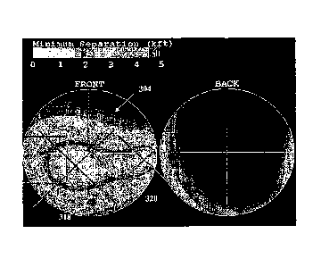
Figure 2c shows an example of a preferred display in accordance with the
present invention. The left disc 212 is a zenithal projection of the front
hemisphere of directions around own-aircraft, where the zenith is directly
ahead.
The right disc 214 is the rear hemisphere, which is included because a
conflict
situation could originate from a faster intruder behind own-aircraft.
The cross hairs are aligned with own-aircraft body axes. That is, the centre
of the
front projection corresponds to the longitudinal body axis of own-aircraft, or
the
pilot's viewpoint straight ahead. The centre of the rear projection is
directly
opposite, towards the rear of own-aircraft.
Equal radial angles in 3D, relative to the central directions, are represented
as
equal radial distances from the centres of the projections. The circumferences
of
the circles are at 900 from the centres, and both circles represent a ring
centred
on the pilot in a plane at right angles to the longitudinal axis.
The LOS, giving the direction of the intruder 202 from own-aircraft 200, is
preferably shown as a square 216. The size of the square indicates the
distance
to the intruder, but its minimum size is preferably fixed. Collision points
218 and
220 are preferably represented as crosses. In similar regard to the intruder,
the
size of the collision points 218, 220 indicates the distance to the potential
collision. The band surrounding the collision points define a conflict zone
222.
The variations in shading inside the conflict zone are a representation of the
miss
distance, or future minimum separation, between own-aircraft and intruder for
all
hypothetical own-aircraft directions. That is, the variations in shading
define
degrees of conflict. Preferably, the shading is a degree of colours to allow
the
pilot to immediately associate a miss distance with a level of danger.
To further explain how the varying degrees of conflict are calculated, a
hypothetical direction for own-aircraft is chosen. That is, the cross hairs
are
notionally positioned toward a desired direction, with existing speed. This is
8
CA 02635817 2008-07-21
WO 2007/095671
PCT/AU2007/000179
referred to as a miss point. Referring to Figure 2c, should the intruder
continue
with its current velocity vector, a hypothetical miss distance may be
calculated
(discussed below) in relation to the miss point.
Preferably, a colour is chosen from the legend 224 appropriate for this miss
distance, and a screen pixel is coloured accordingly at that miss point.
Appropriate shading may be applied to indicate the degree of conflict if a
colour
display is unavailable. If the miss distance is calculated to be beyond the
range of
the legend 224 ¨ which is 5 kft in Figure 2c ¨ then the pixel, or miss point,
is left
black. Continuing with this algorithm, the miss distance may be calculated for
a
continuum of hypothetical own-aircraft directions, resulting in the displayed
degree of conflict.
The varying degree of conflict inside the conflict zone allows the pilot to
immediately evaluate a level of danger associated with any course that might
be
taken. Therefore, if the intention is to avoid the collision points, the pilot
may
steer the vehicle so as to ensure an adequate miss distance (immediately
derived by the colour/shading associated with that miss point). If it is the
intention
to intercept the intruder, the pilot may steer the vehicle toward the
collision point,
evaluating the degree of conflict to assist with the direction for intercept.
Preferably, the display includes data information 226 to assist the pilot. A
preferred embodiment of the invention as shown in Figure 2c further includes,
but
is not limited to, the current distance of the intruder alongside its symbol,
and the
distance and time to the collision points. An immediate indication of the
degree of
conflict is also preferably shown in a separate representation 228. The time
and
distance to closest approach 230 may also be shown.
Although not shown, further data information preferably includes visual
indications, such as arrows, representing the position of cross (i.e. above,
below,
left or right) of own-aircraft when passing the intruder. In addition, a
numerical
9
CA 02635817 2008-07-21
WO 2007/095671
PCT/AU2007/000179
value HM of the vertical component representing the miss distance is
preferably
included when the position of cross is above or below the intruder. Also, a
numerical value Wm of the horizontal component of the miss distance may be
included when the position of cross is to the left or right of the intruder.
Consequently, the directions of the arrows, and value of the miss distance
indicates how own-aircraft should steer to vary the degree of conflict
depending
on whether a conflict is to be avoided or the intruder is to be intercepted.
Figure 2d shows another embodiment of the display and depicts a Mercator
projection of the whole sphere. The flight situation shown here, is the same
situation shown in Figure 2c. In similar regard to Figure 2c, the axes of the
display are the axes of own-aircraft. Equal angles of azimuth are represented
as
equal horizontal distances. Equal angles of elevation are represented as equal
vertical distances. The point exactly above own-aircraft, relative to its
axes, is
mapped onto the upper edge, so directions in this vicinity are greatly
magnified
and distorted. Similarly, the point exactly below own-aircraft is mapped onto
the
lower edge. This projection has the merit of continuity of front and rear
projections, except for a vertical cut behind own-aircraft.
This display of Figure 2d incorporates a projection of the horizon which, at
this
instant, is flat and level. Points above the horizon are preferably depicted
in a
different colour/shade to assist the pilot. As own-aircraft pitches up, the
horizon
appears to fall near the centre and to rise near the left and right edges (as
seen
in Figure 3d). As own-aircraft banks in a turn, it tilts and adopts a
sinusoidal
shape. A horizon (not shown) could be added to the double hemisphere
projection of Figure 2c, if desired.
The inner window 232 of Figure 2d approximates a pilot's typical visual field
of
view. That is, -90 to +90 horizontally and -20 to +20 vertically relative
to the
aircraft's lateral and longitudinal axes, respectively.
CA 02635817 2008-07-21
WO 2007/095671
PCT/AU2007/000179
Figure 3a is a further top view of the situation described above in relation
to
Figure 2, after a certain amount of time has elapsed and the potential
conflict
situation between own-aircraft 300 and an intruder 302 is closer. In similar
regard
to Figures 2a and 2b, dashed lines 301 and 303 show the direction of the
current
velocity vector of own-aircraft 300, and intruder 302 respectively. Lines 305
and
307 emanating from own-aircraft show the directions that would lead to
conflict.
As can be seen in Figure 3b, own-aircraft 300 has taken an evasive manoeuvre
to climb.
The size of the conflict zone 304 on the display in Figure 3c has increased in
size
in comparison to Figure 2c to create a greater visual impression of danger as
is
appropriate. This also conveys the information that own-aircraft's safe
steering
directions are more extreme and require urgent action.
An alternative display is shown in Figure 3d depicting a Mercator projection
of the
whole sphere. In this embodiment, data information 306 is shown at the bottom
of
the display, giving accurate information to the pilot of the vehicle regarding
the
potential collision point.
As the situation continues, own-aircraft continues to climb to avoid the
collision
point. The skilled person will appreciate that the crosshairs of the zenithal
projection of Figure 3c, and the Mercator projection shown in Figure 3d
likewise
move to a safer region in the conflict zone depicted by colour or shading
indicating an acceptable degree of conflict.
Therefore, to summarise the situation of Figures 2 a ¨ d, and Figures 3 a ¨ d,
own-aircraft 200 identifies the main collision point 218 nearly straight
ahead. This
is indicated by a bright colour/shading at own-aircraft's current heading and
in the
data information box at 228.
11
CA 02635817 2008-07-21
WO 2007/095671
PCT/AU2007/000179
Minor drifts in direction could lead to a conflict. Therefore, own-aircraft
may turn
to the right, which the display supports in accordance with an acceptable
degree
of conflict. Were the intruder 202 to maintain its course, there is the risk
from the
second collision point 220 to own-aircraft's right at 700.
Own-aircraft decides to increase the predicted vertical separation by
initiating a
climb, as shown in Figures 3a ¨ 3c. Over a period of 10 seconds own-aircraft
300
rotates upward to a 50 climb angle, and then maintains this angle. Own-
aircraft
300 allows a small turn to the right at 0.15 per second. The intruder 302
does
not change direction, as it is not aware of the presence of own-aircraft 300
in this
instance. The main collision point 318 on the display drifts down and to the
left,
as desired. The projected separation measures will now increase as shown in
the
data information box 306. The degree of conflict is indicated by a
colour/shading
at own-aircraft's current direction (crosshairs 320 in Figure 3c, and
crosshairs
324 in Figure 3d) and in the data information box at 328.
It will be appreciated that in some circumstances, such as a retreating
intruder,
there is no collision point. However, the conflict zone and degree of conflict
may
still be present, with some inner shading/colours missing.
The system of the present invention may display multiple conflict zones
relating
to more than one intruder. Additional conflict zones may be caused by the
existence of weather or terrain. The required information is calculated as
discussed below, and superimposed onto the display with their symbols (e.g.
crosses and squares), conflict zones and associated degrees of conflict. Where
a
display pixel would have different colours or shade for two intruders (that
is, the
degrees of conflict varies for the same position in a conflict zone), it is
preferably
assigned the colour/shading of the smaller miss distance.
A further display embodiment is shown in Figure 4 of the flight situation
discussed above in accordance with Figures 3a ¨ 3d. This is a zenithal
projection
12
CA 02635817 2008-07-21
WO 2007/095671
PCT/AU2007/000179
of the whole sphere of directions around own-aircraft. The inner disc 400 is
identical to the front hemisphere zenithal projection in Figure 3c, so that
equal
radial angles are represented as equal radial distances. However, in this
projection the radial angles are continued out to 1800. The point exactly
behind
own-aircraft is mapped on to the outer circumference 402, so directions in
this
vicinity are greatly magnified and distorted.
The horizon (not shown) in this representation would form a closed curve which
might be difficult to interpret. It does however have the merit of continuity
of front
and rear hemispheres. Preferably, the displays of the current invention may be
interchanged as desired by the operator of the vehicle.
Preferably, the range of angles in any of the projections could be limited in
order
to show small angle changes. Additionally, the degree of conflict may be
varied in
accordance with the pilot's requirements, or according to an algorithm. This
advantageously allows finer resolution of separations when aircraft are
dangerously close, and need to manoeuvre more accurately.
It will be appreciated by those skilled in the art that a monochrome display
may
be used instead of a colour image or a varying shaded image to represent the
degree of conflict. Preferably a monochrome display, such as the variations
shown in Figures 5a, 5b, and 5c, will contain one or more contour lines 500 to
provide an immediate indication of the degree of conflict. Each contour on the
topographic-type display corresponds to a constant miss distance, hence a
constant degree of conflict. Derivatives of these displays are particularly
useful
for inclusion in a head-up display (HUD).
Figure 6 depicts a further design in accordance with an embodiment of the
present invention for a display on the instrument panel of a ship's bridge.
The
display is employed to immediately indicate a degree of conflict. That is, the
level
of danger of collision with other vessels or other obstacles such as terrain.
13
CA 02635817 2008-07-21
WO 2007/095671
PCT/AU2007/000179
The display is a two-dimensional plan view. The crosshairs are aligned with
ownship's axes, so that directly ahead relative to the vessel is at 12 o'clock
on .
the display. The inner hand 600, shown in this instance at around 11 o'clock,
is
the current LOS of an intruder. The intruder is currently on a track that
crosses in
front of ownship.
The coloured or shaded bands 602 shown in the outer disc on the display
indicate the varying degrees of conflict associated with the miss distance for
each
hypothetical velocity of ownship.
Depending on the vessel's immediate environment, a relevant scale for the
degree of conflict may be selected. For example, a vessel in open sea may have
a larger scale than that required for a harbour patrol vessel. The associated
legend 604 preferably gives a numerical value of miss distance in relation to
each
degree of conflict. Miss distances can be measured from the centre point of
each
ship, or the dimensions and orientations of the vessel can be factored in.
The display of Figure 6 shows that, on its current heading, ownship will miss
the
intruder by about 300 units. The dangerous direction for ownship is at 1
o'clock,
leading to a collision point.
If the collision point is a fixed object (e.g. terrain), the degree of
conflict would still
be displayed in a manner in accordance with the present invention. Those
skilled
in the art would appreciate that an inner hand need not be present in this
instance to indicate a LOS for a fixed potential collision point.
The display would preferably be augmented by numerical values (not shown),
indicating time and distance to collision points. Additional intruders would
be
indicated by another LOS hand and another set of coloured/shaded bands. The
14
CA 02635817 2008-07-21
WO 2007/095671
PCT/AU2007/000179
LOS hand could be replaced by a symbol, or other obvious variant, on the
perimeter.
It will be appreciated by those skilled in the art that such displays
described
above by way of example of an embodiment of the present invention are not
limited to being located in the vehicle experiencing the potential conflict.
For
example, the system and method of the present invention may be implemented in
an air traffic control system.
Turning now to the preferred method for calculating the degree of conflict.
The
following nomenclature will be used throughout the calculations discussed
below.
VF = velocity vector of own-aircraft
VF = speed of own-aircraft
VT = velocity vector of intruder
VT = speed of intruder
VR = velocity vector of own-aircraft relative to intruder
U = unit vector parallel to VR
U LOS = unit vector from own-aircraft to intruder
R0 = current 3D distance between own-aircraft and intruder
RmD = 3D miss distance between own-aircraft and intruder
x = coordinate parallel to U Los
= = coordinate perpendicular to U Los in the plane of U.Los
and VT
= coordinate perpendicular to x and y
VRõ = x component of VR; similarly for VRy and VRz
VTx = X component of VT; similarly for VT), and VT,
VF = hypothetical velocity vector of own-aircraft
X = x component of VF ; similarly for Y and Z
CA 02635817 2008-07-21
WO 2007/095671
PCT/AU2007/000179
= semi-angle of cone
/3 = tan
h = distance of a point from the vertex of the cone in the x
direction
h+(0) = solution of equation (12); h_(0) is the other solution
= polar angle of a point around the axis of the cone
CDT' = Cockpit Display for Traffic Information
LOS = Line Of Sight
Values for the calculations below may be received by known methods such as
radio data link transmission. Preferably, these values are calculated with the
accuracy and precision of received high resolution coordinates from a Global
Positioning System (GPS).
With reference to the collision geometry in Figure 7a, own-aircraft has 3D
velocity
vector VF, the intruder has 3D velocity vector VT , their current 3D distance
is
Ro and the LOS to the intruder is given by the unit vector ULos.
Here F is for First person and T is for inTruder or Threat or Traffic. From
the
point of view, or frame of reference of the intruder, own-aircraft appears to
move
with velocity VR=VF¨VT in a direction with unit vector UR=VRIIVR if VFVT =
Figure 7b shows that the miss distance is the shortest path from the intruder
to
the line through own-aircraft in the direction of UR . The shortest path is
the
perpendicular to the line. The component of the relative position vector
RoULos
along UR is C= RoULos URI
where the dot denotes the scalar product. If
=
VF =VT then C =0. Hence the vector from the intruder to own-aircraft at
closest
approach would be
Rm = CUR¨ RoU Los (1)
16
CA 02635817 2008-07-21
WO 2007/095671
PCT/AU2007/000179
Pythagoras' theorem gives the miss distance as
RAID = RAI = AIR02 ¨ C2 (2)
This formula is used to compute the miss distances for all hypothetical own-
aircraft directions (miss points), resulting in the degree of conflict shown
as the
colour or shaded regions in Figures 2 to 6. For own-aircraft's current
direction,
the component HM of Rm along the upward axis of own-aircraft and the
component Wm along its right wing are also calculated. They show how far own-
aircraft will pass above and to own-aircraft's right of the intruder at
closest
approach, and their values are preferably given in the information data
display.
Collision points correspond to RmD = 0, which occur when U = U LOS as (2)
shows, so that U Los , VF and VT would be coplanar. Orthogonal coordinates
(x,y,z) are used in which the x axis lies along U Los and the y axis lies in
the
=
plane of U Los and VT, so that VT has a positive y component VTy . The z axis
is defined by the right hand rule. The collision triangle shown in Figure 8a
shows
a case where VF >VT . If VF <Vry there is no collision point. Otherwise
Pythagoras' theorem gives the standard formula:
VR1 = ¨ T/T., + jv ¨ VT2y (3)
and own-aircraft's velocity vector would be
VF1= VT IVRU LOS (4)
17
CA 02635817 2008-07-21
WO 2007/095671
PCT/AU2007/000179
The direction of this vector is projected on the displays as a cross. Figure
8b
illustrates a case where VF <VT and there are two collision directions. For
the
second, the plus before the square root in (3) becomes a minus. This gives a
second own-aircraft velocity vector VF7 , whose direction is projected on the
display as a second cross. Its parameters are preferably given against the
lower
cross in the information data section of the display. For own-aircraft's
current
velocity vector and for the collision directions, the times Cy VR to reach
minimum
separation are shown in the data box.
Referring back to Figure 5a a line plot version of a zenithal display is
shown,
where the closed curve conflict zone corresponds to a miss distance of 2000
feet.
The collision point is now represented by a dot, instead of a cross. The LOS
is
shown as a solid square and the cross hairs are reduced. For the purposes of
ease of description, both aircraft are flying level and own-aircraft has a
speed of
500 ft/s. The intruder has a speed of 400 ft/s, is at a distance of 6000 feet,
and is
300 to the left and 7 below own-aircraft. The intruder is crossing in front
of own-
aircraft at 90 to own-aircraft's path. The collision point could be reached
in 10.7
seconds. However, Figure 5a indicates that they will miss by about 1200 feet.
A computer program may obtain the 2000 foot contour, pixel by pixel, but this
is
computationally expensive and does not generate a smooth curve. Instead, an
equation for the contour is obtained by referring to the collision geometry in
Figure 8a. Equation (2) can be written in the form
(RoULos = VR )2 =-= (4 ¨ 41D)IvR12 (5)
which can be expressed in components as
Rd vi,, = (Rd ¨ Riõ))(vix + v + Viz) (6)
18
CA 02635817 2008-07-21
WO 2007/095671
PCT/AU2007/000179
The hypothetical own-aircraft velocity is fiF = (X,Y,Z) where the components
X,Y,Z are variables which will define the contour. Therefore,
VR,
VRy = Y ¨ VTy (7)
VR, = Z
because VT has no z component. Now (6) reduces to
P2(X ¨ Vrx)2 = (Y _ v-Ty)2 + z2 (8)
where
Rim
,6 = (9)
\ 4, -4,,,
.
Equation (8) defines a cone with vertex VT, axis along the x axis, and semi-
angle 0 = arctan /3 . Figure 9 shows one example. Recalling that own-
aircraft's
actual current speed VF 'IT,7F1 is assumed for all hypothetical own-aircraft
directions, then
2
X2 +Y2 +Z2 = VF (10)
This defines the surface of a sphere of radius 1/F' centred at the origin, as
illustrated in Figure 9. The simultaneous equations (8) and (10) define two
closed
curves, where the cone intersects the sphere. The hypothetical own-aircraft
velocities VT, ----(X,Y,Z) then lie on the curves of Figure 9. Also, the
collision
points lie at the intersection of the axis of the cone with the surface of the
sphere,
19
CA 02635817 2008-07-21
WO 2007/095671 PCT/AU2007/000179
because p= 0 when RmD = 0. The VF 's have directions given by the unit vector
To plot the projections of the UF 's in Figure 9, (8) is written
parametric form
X¨ Va = h
Y ¨ VTy = h,8 cos 0 (11)
Z = hfisin0
where h is the vertical distance above the vertex of the cone and 0 is the
polar
angle around the axis of the cone in Figure 9. Substituting this in (10),
gives the
quadratic equation for h
1220 + /1 -2,
) 2h(V.T.t. Vryi6COS 0) -I- (17.7? - = 0 (12)
The two solutions are denoted h,(0) and h_(0) . When h( ) is substituted in
(11), the equation of the upper curve in Figure 9 is expressed in terms of the
single parameter 0. The curve can then be generated from (11) by stepping
through closely spaced values of 0 in the range (0, 2r). The directions UF are
then projected zenithally to produce the display of Figure 5a.
A lower curve in Figure 9 could be obtained from h_(0) in a similar way.
However,
the lower half of the cone corresponds to a minimum separation occurring in
the
past, so it is not physically relevant.
Considering a scenario as depicted in Figure 10a however, both curves lie on
the
upper half of the cone, and occur in the future. The resulting projection
produces
two contours as shown in Figure 5c.
CA 02635817 2008-07-21
WO 2007/095671
PCT/AU2007/000179
The possible situations are as follows. If own-aircraft is faster ( VF VT ) ,
there is
exactly one collision point. This follows, because the vertex of the cone is
inside
the sphere in Figure 9. If own-aircraft is slower ( VF < VT ) , then the
vertex is
outside the sphere and there are two main cases:
(i). If1/TX > 0 there is no collision point, because the vertex of the cone
lies
above the sphere (see Figure 10c). IfT/TX <0 and VT), > VF there is no
collision
point, because the vertex of the cone lies to the side of the sphere (see
Figure
10d). In both cases, if VT is large enough, there is no conflict zone
(contour)
either.
(ii). If VT, <0 and VT), < VF there are two conflict points, as the vertex of
the cone lies below the sphere (see Figures 10a and lob). There is always at
least one contour. A single contour, which could be dumbbell shaped, can
enclose both collision points (see Figure 10b) resulting in a conflict zone.
Alternatively, two separate contours can each contain one collision point (see
Figure 10a). Unless VF VT , one collision point is much closer and has a much
larger contour. Mathematical conditions for the different types of contours
can be
deduced from these figures.
By way of example, Figure 5b shows the contours from Figure 2, whereas Figure
5c shows the contours from Figures 3 or 4. Figure 5c is an example like Figure
10b. These line plot displays could be used to resolve the conflict as
described
above, though the visual information is less complete. Preferably, many miss
distances are calculated to give a beneficial indication of a degree of
conflict.
It will be appreciated that vertical dimensions of aircraft are relatively
small and
vertical manoeuvres are required operationally for aircraft. Therefore, it
might be
more convenient to have a finer scale in the vertical direction. This would
possibly result in a vertical colour legend and a horizontal colour legend. A
21
CA 02635817 2008-07-21
WO 2007/095671
PCT/AU2007/000179
horizontal miss distance of a , say, appears on the same contour (same
colour/shading) as a vertical miss distance of b, say, where the ratio bia is
a
fixed number less than one, based on dimensions and manoeuvrability of the
vehicle. For an angle 0 relative to the horizontal in the stereo plot, a
suitable
value of miss distance is
Va2 cos2 + b2 sin2 0 (13)
This miss distance may be found as a point on the display, along the radius at
angle 0 , and a contour drawn through that point, or colours/shades the pixel
with
the associated colour/shading. The resulting display then gives a finer
resolution
of vertical miss distances allowing a more accurate measure of a degree of
conflict.
It will be appreciated by those skilled in the art that the above calculations
are not
limited to single-plane vehicle conditions (i.e. constant direction). Further
derivation of coordinate points can result in the hypothetical calculation of
the
intruding vehicle banking (turning), or altering speed, and the probable
degree of
conflict that such manoeuvres would cause own-aircraft. For example, a
hypothetical conflict in minimal time could be calculated, to inform the pilot
of
own-aircraft of a possible imminent conflict if the intruder turns in a
dangerous
way.
It will of course be realised that whilst the above has been given by way of
an
illustrative example of this invention, all such and other modifications and
variations
hereto, as would be apparent to persons skilled in the art, are deemed to fall
within
the broad scope and ambit of this invention as set forth in the following
claims.
22