Note: Descriptions are shown in the official language in which they were submitted.
CA 02641813 2008-08-08
WO 2007/091086 PCT/GB2007/000459
1
Electromagnetic Surveying
The present invention relates to electromagnetic (EM) surveying, in particular
for seabed logging, and is concerned with providing a system for determining
the resistivity or conductivity of subsea strata, especially the upper strata,
e.g.
at a depth of up to about 100 in or even greater.
Currently, the most widely used techniques for geological surveying,
particularly in sub-marine situations, are seismic methods. These seismic
techniques are capable of revealing the structure of the subterranean strata
with
some accuracy. However, whereas a seismic survey can reveal the location and
shape of a potential reservoir, it can normally not reveal the nature of the
reservoir.
It has been appreciated by the present applicants that while the seismic
properties of hydrocarbon filled strata and water-filled strata do not differ
significantly, their electromagnetic resistivities do differ. Thus, by using
an
electromagnetic surveying method, these differences can be exploited and the
success rate in predicting the nature of a reservoir can be increased
significantly.
Consequently, a method and apparatus embodying these principles form the
basis of the present applicants' EP-A- 1256019.
This contemplates a method for searching for a hydrocarbon containing
subterranean reservoir which comprises: applying a time varying
electromagnetic field to subterranean strata; detecting the electromagnetic
wave
field response; seeking, in the wave field response, a component representing
a
refracted or ducted wave; and determining the presence and/or nature of any
CA 02641813 2008-08-08
WO 2007/091086 PCT/GB2007/000459
2
reservoir identified based on the presence or absence of a wave component
refracted or ducted by hydrocarbon layer.
A ducted wave behaves differently, depending on the nature of the stratum in
which it is propagated. In particular, the propagation losses in hydrocarbon
stratum are much lower than in a water-bearing stratum while the speed of
propagation is much higher. Thus, when a hydrocarbon-bearing reservoir is
present, and an EM field is applied, a strong and rapidly propagate.d ducted
wave can be detected. This may therefore indicate the presence of the
reservoir
or its nature if its presence is already known.
Electromagnetic surveying techniques in themselves are known. However,
they are not widely used in practice. In general, the reservoirs of interest
are
about 1 km or more below the seabed. In order to carry out electromagnetic
surveying as a stand alone technique in these conditions, with any reasonable
degree of resolution, short wavelengths are necessary. Unfortunately, such
short wavelengths suffer from very high attenuation. Long wavelengths do not
provide adequate resolution. For these reasons, seismic techniques are
preferred.
However, while longer wavelengths applied by electromagnetic techniques
cannot provide sufficient information to produce an accurate indication of the
boundaries of the various strata, if the geological structure is already
known,
they can be used to determine the nature of a particular identified formation,
if
the possibilities for the nature of that formation have significantly
differing
electromagnetic characteristics. The resolution is not particularly important
and so longer wavelengths which do not suffer from excessive attenuation can
be employed.
CA 02641813 2008-08-08
WO 2007/091086 PCT/GB2007/000459
3
The resistivity of seawater is about 0.3 ohm-m and that of the overburden
beneath the seabed would typically be from 0.3 to 4 ohm-m, for example about
2 ohm-m. However, the resistivity of an oil reservoir is likely to be about 20-
300 ohm-m. This large difference can be exploited using EM surveying
techniques. Typically, the resistivity of a hydrocarbon-bearing formation will
be 20 to 300 times greater than water-bearing formation.
Thus, an EM source such as an electric dipole transmitter antenna on or close
to the sea floor induces (EM) fields and currents in the sea water and in the
subsurface strata. In the sea water, the EM-fields are strongly attenuated due
to
the high conductivity in the saline environment, whereas the subsurface strata
with less conductivity potentially can act as a guide for the EM-fields (less
attenuation). If the frequency is low enough (in the order of 1 Hz), the EM-
waves are able to penetrate deep into the subsurface, and deeply buried
geological layers having higher electrical resistivity than the overburden (as
e.g. a hydrocarbon filled reservoir) will affect the EM-waves. Depending on
the angle of incidence and state of polarisation, an EM wave incident upon a
high resistive layer may excite a ducted (guided) wave mode in the layer. The
ducted mode is propagated laterally along the layer and leaks energy back to
the overburden and receivers positioned on the sea floor. The terms
"refracted"
and "ducted" are used in this specification to refer to this wave mode.
In seabed logging, a signal is emitted from a towed source antenna, parallel
to,
and close to the sea floor; and the wavefield response detected by a number of
stationary receivers, distributed on the sea floor, is recorded. The strength
of
the emitted signal is proportional to the current IA delivered to the antenna,
and
this current is accurately monitored and recorded. [If the current source is
very
stable, the current would, of course be constant.]
CA 02641813 2008-08-08
WO 2007/091086 PCT/GB2007/000459
4
It is an object of the present invention to provide an apparatus and method
for
detecting and/or determining the nature of a subterranean reservoir.
According to one aspect of the invention, there is provided a method of
determining the nature of a subterranean stratum which comprises: deploying
an electric dipole transmitter antenna, preferably with its axis generally
horizontal; applying an electromagnetic (EM) field to the stratum containing
the reservoir using the transmitter; measuring the current and voltage at the
antenna terminals during the EM transmission; and determining the nature of
the stratum from changes in the measured voltage.
Changes in the nature of subterranean strata cause changes in the resistivity
of
the seabed as a whole beneath the sea floor. Since the resistivity of the
source,
antenna and sea water should remain constant, these changes in seabed
resistivity alone may cause the voltage at the antenna terminals to vary and
so
the variations in antenna voltage will be representative of the of the changes
in
the nature of the strata in the seabed.
Thus, analysis of the logged receiver data may reveal the presence of a fast,
low attenuation guided wave, and thus the presence of a high resistivity
stratum
which may be oil bearing.
High resistivity may, however, occur, not in oil bearing strata only, but also
in
strata consisting of e.g. solid salt or rock containing little or no water. In
order
to determine the nature of the high resistivity stratum, it is generally
necessary
to carry out a detailed analysis of the logged reciever data, in order to
create a
model, based on the seismic data, in which resistivity values are assigned to
the various strata. From the geological knowledge of the region in question,
the
most likely nature of a high resistivity stratum may then be ascertained.
CA 02641813 2008-08-08
WO 2007/091086 PCT/GB2007/000459
The accuracy of the model is limited by the receiver data, and may be
improved by utilising other available information. One means of obtaining such
additional information is by monitoring the input impedance of the towed
5 transmitter antenna ZA. = VA/IA, where IA is the antenna current and IA the
terminal voltage.
The input impedance of the towed transmitter antenna is determined by the
following parameters:
1. The configuration of the antenna.
2. The conductivity of the sea water
3. The position and orientation of the antenna with respect to the sea floor
4. The topography of the sea floor (plane or otherwise).
5. The resistivity distribution below the sea floor.
Parameters 1-4 may be separately monitored and accounted for, and the
remaining variations of ZA provide information about the resistivity
distribution
below the sea floor.
In one embodiment, the transmitter is located on or close to the seabed or the
bed of some other area of water. Preferably, the frequency of the EM field is
continuously varied over the transmission period. Preferably, the field is
transmitted for a period of time for 3 seconds to 60 minutes, for example,
from
10 seconds to 5 minutes. Preferably, the method is repeated at different
locations.
In a more preferred embodiment, the transmitter is towed over the seabed while
the EM field is being transmitted. The transmitter is preferably towed as
close
CA 02641813 2008-08-08
WO 2007/091086 PCT/GB2007/000459
6
to the sea floor as possible. Preferably, the distance to the sea floor should
be
much less than the length of the antenna (e.g. 20 m to 200 m), and much less
than the wavelength of the frequencies to be used.
Preferably, the transmitter includes an inertia sensor to sense the difference
between a change in the sea floor height and a rise/fall of the transmitter.
In addition, the transmitted signal shape may be modified so that it contains
more of the harmonics which are useful for mapping the conductivity. It will
be understood that calculation of the conductivity of the upper strata of the
seabed as a function of position and depth is also desirable.
Preferably, the method of the invention is carried out during a conventional
EM
survey using receivers to detect the transmission wavefield response. The
method may also be used in conjunction with seismic surveying techniques.
The invention extends to a method for detecting different subterranean strata
and is particularly applicable to the detection and identification of
hydrocarbon
bearing strata.
Preferably, the wavelength of the transmission is given by the formula
O.Olh <_ k_< 30h; or more preferably,
0. l h <_ k < 10h
wherein A is the wavelength of the transmission through the subsea strata and
h is the distance from the seabed to the strata under investigation.
Preferably,
the transmission frequency is from 0.01 Hz to 1 kHz, for example, from 0.1 to
20 Hz.
CA 02641813 2008-08-08
WO 2007/091086 PCT/GB2007/000459
7
The invention extends to a process for the production of a survey report by
carrying out a method according to the invention, and a survey report produced
in this way.
The invention may be carried into practice in various ways and an embodiment
will now be described by way of example with reference to the accompanying
drawings, in which:
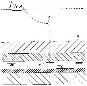
Figure 1 is a schematic diagram showing how the invention may be carried out
in practice.
Figure 1 shows an antenna 11 towed by a vessel 12 at a distance h above the
sea floor 13. The antenna 11 emits a wavefield, whose strength is proportional
to the current IA delivered to the antenna 11, and this is accurately
monitored
and recorded. By also monitoring and recording the voltage VA at the antenna
terminals, the impedance of the antenna, ZA = VA/IA, may be calculated. ZA is
a function of the frequency,f, and when a multifrequency signal is employed,
this function may be found within a range of frequencies extending from f= 0
to a maximum frequency fmax, determined by the frequency spectrum of the
signal, and the accuracy of the voltage and current measurements. By means of
the impedance function, the following important parameters may be calculated,
namely, the distance from the antenna to the sea floor, the conductivity of
the
sea water, and the step in conductivity at the sea floor, and possibly more
detail
of the conductivity variation immediately below the sea floor.
Part of the emitted signal is reflected at the sea floor, the reflection
coefficient
being
CA 02641813 2008-08-08
WO 2007/091086 PCT/GB2007/000459
8
61 - 62
p = (1)
61 62
where 6i and a2 are the conductivities above and below the sea floor 13,
respectively. The reflected signal induces a voltage VR in the antenna,
thereby
altering the voltage and the current at the antenna terminals, thus ultimately
causing a change in the antenna impedance. The ainplitude and phase of VA
vary with the frequencyf, and the distance h between the antenna and the sea
floor. At sufficiently high frequencies, VA is negligible, and the impedance
depends.only on the frequence, and on the conductivity 61, which may then be
calculated.
Assuming 62 constant, the reflected signal may be found from the simple model
indicated in Figure 1, as emitted from an image antenna 14 located the
distance
h below the (plane) sea floor, with 62 = 61. The current of the image antenna
is
Pla=