Note: Descriptions are shown in the official language in which they were submitted.
CA 02660339 2009-02-06
WO 2008/021943 PCT/US2007/075562
GEOSPATIAL MODELING SYSTEM FOR PERFORMING FILTERING
OPERATIONS BASED UPON A SUM OF DIFFERENCES OF A GIVEN AND
NEIGHBORING LOCATION POINTS AND RELATED METHODS
The present invention relates to the field of topographical modeling,
and, more particularly, to geospatial modeling systems and related methods.
Topographical models of geographical areas may be used for many
applications. For example, topographical models may be used in flight
simulators and
for planning military missions. Furthermore, topographical models of man-made
structures (e.g., cities) may be extremely helpful in applications such as
cellular
antenna placement, urban planning, disaster preparedness and analysis, and
mapping,
for example.
Various types and methods for making topographical models are
presently being used. One common topographical model is the digital elevation
map
(DEM). A DEM is a sampled matrix representation of a geographical area which
may
be generated in an automated fashion by a computer. In a DEM, coordinate
points are
made to correspond with a height value. DEMs are typically used for modeling
terrain
where the transitions between different elevations (e.g., valleys, mountains,
etc.) are
generally smooth from one to a next. That is, DEMs typically model terrain as
a
plurality of curved surfaces and any discontinuities therebetween are thus
"smoothed"
over. Thus, in a typical DEM no distinct objects are present on the terrain.
One particularly advantageous 3D site modeling product is RealSite
from the present Assignee Harris Corp. RealSite may be used to register
overlapping images of a geographical area of interest, and extract high
resolution
DEMs using stereo and nadir view techniques. RealSite provides a semi-
automated
process for making three-dimensional (3D) topographical models of geographical
areas, including cities, that have accurate textures and structure boundaries.
Moreover,
RealSite models are geospatially accurate. That is, the location of any given
point
within the model corresponds to an actual location in the geographical area
with very
high accuracy. The data used to generate RealSite models may include aerial
and
-1-
CA 02660339 2011-05-31
WO 2008/021943 PCT/US2007/075562
satellite photography, electro-optical, infrared, and light detection and
ranging
(LIDAR).
Another advantageous approach for generating 3D site models is set
forth in U.S. Patent No. 6,654,690 to Rahmes et al., which is also assigned to
the
present Assignee. This patent discloses an automated method for making a
topographical model of an area including terrain and buildings thereon based
upon
randomly spaced data of elevation versus position. The method includes
processing
the randomly spaced data to generate gridded data of elevation versus position
conforming to a predetermined position grid, processing the gridded data to
distinguish building data from terrain data, and performing polygon extraction
for
the building data to make the topographical model of the area including
terrain and
buildings thereon.
One potentially challenging aspect of generating geospatial models
such as DEMS is distinguishing different types of geospatial data, e.g.,
foliage data
and building data. This is because foliage such as trees results in noisy data
(e.g.,
LIDAR data) because of the varying heights and contours of the leaves, etc.
Even
though buildings generally provide relatively smooth data towards the centers
of the
buildings, the edges of the buildings where a transition from roof to ground
occurs
often produces noisy data as well. Moreover, foliage is often placed directly
adjacent
to or overlies buildings, which makes distinguishing the two using automated
computer processing techniques particularly challenging. As a result, if an
operator
wants to separate foliage and building data to provide a model of just one or
the other
types of data, the operator may have to manually designate foliage and
buildings in a
raw image data scene. However, this can be extremely time consuming and, thus,
cost
prohibitive in many applications.
In view of the foregoing background, it is therefore an object of the
present invention to provide a geospatial modeling system having geospatial
data type
separation features and related methods.
This and other objects, features, and advantages are provided by a
geospatial modeling system which may include a geospatial model database and a
-2-
CA 02660339 2009-02-06
WO 2008/021943 PCT/US2007/075562
processor. The processor may cooperate with the geospatial model database for
performing at least one noise filtering operation on data comprising
elevations
associated with respective location points. More particularly, the at least
noise
filtering operation may include determining a respective center point
elevation
difference for each location point and based upon a sum of differences between
elevations of a given location point and a plurality of neighboring location
points.
The data may include ground data and foliage data, for example. As
such, data processor may further separate the ground data from the foliage
data based
upon the at least one noise filtering operation. The at least one filtering
operation may
include a first loose tolerance filtering to determine an inclusive estimate
of building
locations, and a second strict tolerance filtering to reduce false building
locations.
Also, the processor may further perform at least one edge recovery operation
to
compensate for noisy building perimeters. In addition, the processor may
perform a
masking operation based upon the inclusive estimate of the building locations
to
generate masked building data. The at least one filtering operation may
further
include a third filtering based upon the masked building data and the output
of the
second strict tolerance filtering.
By way of example, the plurality of neighboring location points
comprises eight neighboring location points. Furthermore, the at least one sum
of
differences operation may also include determining a respective neighboring
points
elevation difference for each pair of adjacent location points based upon a
sum of
differences between elevations of respective center point elevation
differences for the
adjacent location points. The at least one noise filtering operation may
further include
selectively replacing foliage and building data points with nulls based upon
the at
least one sum of differences operation and an elevation difference threshold.
The
geospatial modeling system may also include a display coupled to the processor
for
displaying at least one of the separated foliage and building data.
A geospatial modeling method aspect may include performing at least
one noise filtering operation on data comprising elevations associated with
respective
location points using a processor. More particularly, the at least noise
filtering
-3-
CA 02660339 2009-02-06
WO 2008/021943 PCT/US2007/075562
operation may include determining a respective center point elevation
difference for
each location point and based upon a sum of differences between elevations of
a given
location point and a plurality of neighboring location points.
A computer-readable medium may have computer executable modules
including a geospatial model database module and a processing module
cooperating
therewith for performing at least one noise filtering operation on data
comprising
elevations associated with respective location points. Moreover, the at least
noise
filtering operation may include determining a respective center point
elevation
difference for each location point and based upon a sum of differences between
elevations of a given location point and a plurality of neighboring location
points.
FIG. 1 is a schematic block diagram of a geospatial model system in
accordance with the invention.
FIG. 2 is a flow diagram illustrating a geospatial modeling method in
accordance with the invention for separating building and foliage geospatial
data.
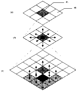
FIGS. 3-5 are 3D grid views illustrating sum of difference filtering
operations in accordance with the method of FIG. 2.
FIGS. 6-15 are a series of screen prints illustrating various aspects of
the method of FIG. 2.
The present invention will now be described more fully hereinafter
with reference to the accompanying drawings, in which preferred embodiments of
the
invention are shown. This invention may, however, be embodied in many
different
forms and should not be construed as limited to the embodiments set forth
herein.
Rather, these embodiments are provided so that this disclosure will be
thorough and
complete, and will fully convey the scope of the invention to those skilled in
the art.
Like numbers refer to like elements throughout.
Referring initially to FIG. 1, a geospatial modeling system 20
illustratively includes a geospatial model database 21 and a processor 22 that
may
advantageously be used for separating different types of geospatial data, such
as
building and foliage data, for example. By way of example, the processor 22
may be a
central processing unit (CPU) of a PC, Mac, or other computing workstation,
for
-4-
CA 02660339 2009-02-06
WO 2008/021943 PCT/US2007/075562
example. A display 23 may also be coupled to the processor 22 for displaying
geospatial modeling data, as will be discussed further below. The processor 22
may
be implemented using a combination of hardware and software components/modules
to perform the various operations that will be discussed further below, as
will be
appreciated by those skilled in the art.
By way of example, the geospatial data may be captured using various
techniques such as stereo optical imagery, Light Detecting and Ranging
(LIDAR),
Interferometric Synthetic Aperture Radar (IFSAR), etc. Generally speaking, the
data
will be captured from overhead (e.g., nadir) views of the geographical area of
interest
by airplanes, satellites, etc., as will be appreciated by those skilled in the
art.
However, oblique images of a geographical area of interest may also be used in
addition to (or instead of) the nadir images to add additional 3D detail to a
geospatial
model. The raw image data captured using LIDAR, etc., may be processed
upstream
from the geospatial model database 21 into a desired format, such as a digital
elevation model (DEM), or this may be done by the processor 22.
Turning additionally to FIGS. 2 through 15, a method for separating
foliage data from the building data using the system 20 is now described.
Initially, a
DEM 50 (FIG. 6) of a given geographical area of interest or scene is
generated, at
Block 30. By way of example, the above-described RealSite system or the
system
set forth in U.S. Patent No. 6,654,690 may be used for generating the initial
DEM. Of
course, other suitable approaches for generating DEMs may also be used. The
DEM
50 may be generated by another computer and stored in the geospatial model
database
21, or it may be created by the processor 22 based upon "raw" geospatial data
(e.g.,
LIDAR data, etc.) stored in the database. The DEM 50 illustratively includes
terrain
(i.e., ground), buildings, and foliage data. Yet, in some applications it is
desirable to
separate one of these types of data, such as the building or foliage data,
from the
remainder of the DEM data so that it can be viewed and/or processed
individually.
To this end, a first step of extracting ground data from foliage and
building data is performed by the processor 22, at Block 31, to generate
foliage and
building data 51. As will be appreciated by those skilled in the art, the
foliage,
-5-
CA 02660339 2009-02-06
WO 2008/021943 PCT/US2007/075562
building, and ground data include elevations or heights associated with
respective
location points or posts.
Following the ground extraction, a first filtering operation is performed
on the foliage and building data 51 using a first loose tolerance to determine
an
inclusive estimate of building locations 52, at Block 32. Referring more
particularly to
FIG. 3, the filtering operation includes defining a center location point 45
and its
neighboring location points 46. Then, the processor 22 performs a sum of
differences
operation which includes determining a respective center point 45 elevation
difference
based upon a sum of differences between elevations of the center point and the
neighboring location points 46, where:
1 1
CenterDifference = I xi, j - xo, o ~. (1)
i=-1j=-1
In the illustrated embodiment, eight neighboring location points 46 are
used, but in other embodiments more or less neighboring location points may be
used.
The above-described sum of differences operation is performed for each of the
foliage
and building data location points within the DEM. That is, each location point
is
defined as a center and the sum of differences with respect to its neighboring
location
points is determined in accordance with equation (1).
The filtering operation further includes determining a respective
neighboring points 46 elevation difference for each pair of adjacent location
points
based upon a sum of differences between elevations of respective center point
elevation differences for the adjacent location points. That is, given two
adjacent
location points, a sum of differences is determined between the two location
point
elevations relative to the original location point elevations (FIG. 4). In the
present
example, there will be eight non-trivial neighbor differences per each center
location
point, where:
NeighborDlfferencedi, dj = I xi, j - xi + di, j + dj . (2)
-6-
CA 02660339 2009-02-06
WO 2008/021943 PCT/US2007/075562
Once the neighboring points elevation differences are determined, then
six adjacent points are identified that are not on a primary diagonal
(indicated by
shading in FIG. 5(a)) for a given center point 45. The eight-neighbor
difference is
then determined for each of the six adjacent points (FIG. 5(b)), as is a
center
difference of each set of the eight neighbor differences (FIG. 5(c)). A self-
similarity is
determined to be the smallest center difference, where higher values
correspond to
larger differences.
The above-described filtering operation allows a "rough" estimation of
the foliage in the building and foliage data DEM 51, which can then be
separated
from the building data to provide the inclusive estimate of building locations
52.
Stated alternatively, using a loose tolerance filtering will identify a large
portion of
the foliage, but will intentionally allow some foliage data to remain (which
appear as
small spots or speckles in FIG. 7) so that little or no building data is
excluded.
Next, a DEM subtract operation is performed, at Block 33, in which
the inclusive estimate of building locations 52 is "subtracted" from the
building and
foliage data 51 to provide a preliminary estimate of the foliage 53. The
processor 22
may then begin edge recovery operations, as indicated by the dashed box 34 in
FIG. 2,
to compensate for noisy building perimeters. More particularly, the first edge
recovery operation includes a null expansion on the inclusive estimate of
building
locations 52, at Block 35, to remove the foliage remnants (i.e., specks)
therein (FIG.
9), and produce an estimate of the buildings without specks 54.
The processor 22 may then perform a null filling operation on the
estimate of buildings without specks 54 to generate a mask of building data 55
(FIG.
10). That is, the null filling approximates geometric shapes of the buildings,
which are
shown in FIG. 11. The mask of building data 55 and the preliminary estimate of
the
foliage 53 are then used to perform a point in poly filtering operation to
generate an
improved estimate of the foliage 56. A next edge recovery operation includes a
DEM
subtract operation, namely subtracting the improved estimate of the foliage 56
from
the building and foliage data 51 to get an improved estimate of the building
data, at
Block 38. The above-described edge recovery operations may then be repeated
one or
-7-
CA 02660339 2009-02-06
WO 2008/021943 PCT/US2007/075562
more times, depending upon the desired accuracy for a given implementation, to
produce a final mask of building data 57 that will be used in a later step.
In addition, a second strict tolerance filtering is also performed on the
building and foliage data 51 to reduce false building locations, and this
filtering
produces a second estimate of the building data 58, at Block 39. More
particularly, the
second filtering operation is similar to the first filtering operation
described above
with reference to FIGS. 3-5, but a more tight or strict tolerance is used. The
relative
values of the strict and loose tolerance thresholds used in the filtering
operations may
be determined based upon factors such as the type of data being processed,
data
resolution, and the desired accuracy of the resulting building and/or foliage
data, for
example, as will be appreciated by those skilled in the art.
A DEM subtract operation is then performed based upon the building
and foliage data 51 and the second estimate of building data 58 to provide a
second
estimate of the foliage data 59, at Block 40 (FIG. 13). Another point in poly
filtering
operation is then performed, at Block 41, based upon the second estimate of
the
foliage data 59 and the final mask of building data 57 to produce a final
estimate of
the foliage data 60. Then, another DEM subtract operation may be performed
using
the building and foliage data 51 and the final estimate of the foliage data 60
to
generate a final building data estimate 61, at Block 42. The processor 22 may
then
selectively display the final separated foliage data 60 or the final building
data 61 on
the display 23, or it may be stored for further processing or usage.
In summary, the above-described approach advantageously uses a
center location point difference of neighbor differences as a noise metric, as
well as
an edge recovery routine to compensate for noisy building parameters.
Furthermore,
use of a loose tolerance to obtain a general idea of where the buildings are,
and then a
strict tolerance to help reduce the changes of false buildings, provides still
further
accuracy. However, it will be appreciated that in certain embodiments some of
the
above-described operations may be omitted or performed in an order different
than
shown or described.
-8-
CA 02660339 2009-02-06
WO 2008/021943 PCT/US2007/075562
The above-described approach may advantageously provide the ability
to automatically detect and/or distinguish foliage from underlying terrain and
man-
made (i.e., building) structures within a DEM, and model them separately. It
may
further allow modeling of foliage as 3D point (i.e., voxels), as well as the
modeling of
man-made structures and terrain as polygons.
-9-