Note: Descriptions are shown in the official language in which they were submitted.
CA 02662444 2009-03-03
WO 2008/044934 PCT/N02006/000350
A METHOD AND SYSTEM FOR DETERMINING A THREAT AGAINST A
BORDER
Field of the invention
The present invention relates to a system and method used in the protection of
borders, and in particular the borders of a country or state, against
intruders of
various kinds.
io Technical background
In a modern society, a country must protect itself against persons passing its
borders outside the official or legal points of entry. The persons in question
may
have various motifs for wanting to hide their entry into a country. This may
be
illegal immigration, smuggling, terrorism, etc. In order to protect the
borders,
various measures may be taken. This may be physical hindrances, such as
fences, various detectors for observing the border line, such as cameras,
radars, infrared line detectors, seismic detectors, or manual control by
border
patrols. The detectors are normally connected to a border station, which is
also
2o headquarter for border patrols. Thus, the border station will receive
information
as alarms from the detectors as well as observations reported by border
patrols.
This information should be used to devise countermeasures against possible
intruders, either by sending out border patrols to apprehend offenders or by
relocating resources, that is fencing and detectors, in order to make the
border
as tight as possible. However, the scattered information received in the
border
station is not easy to exploit. The information supplied by border patrols
passing
at regular intervals may not be representative for the real situation at the
border.
In addition, a detector may tell that an object has passed the border, but not
how severe the intrusion is, i.e. detectors may be tripped by squirrels as
well as
terrorists. Thus, there is a need for a structured approach for disseminating
information gathered in a border station.
In many ways, the situation depicted above corresponds to the threats posed
against computer networks by virus and malicious hackers. However, the
technique used in firewalls and protection software does not readily lend
itself
for protecting physical assets or the borders of a country.
CA 02662444 2009-03-03
WO 2008/044934 PCT/N02006/000350
Summary of the invention
It is an object of the invention to provide a solution to the problems
mentioned
above, and in particular to provide a method and system for determining the
threat against a border. The invention may be used for optimal resource
allocation to produce a good protection of said border, or the best protection
possible with the available resources.
In particular, it is an object to provide a method for determining a threat
against
io a border from objects crossing or trying to cross said border. Said method
includes at least the steps of segmenting the border into border elements of
uniform terrain features, infrastructure and weather conditions, collecting
data of
incidents occurring along a given border element, determining a threat
potential
for said border element, determining a protection factor for the border
element,
and determining a threat against the border element from the threat potential
and protection factor.
The method may be used for warning about an increased threat to a border,
wherein the threat is compared with a threat value threshold. If the threat
2o exceeds the threat value threshold, an alarm is issued.
The method may also be used for allocating protective measures along a
border.
Another object of the invention is to provide a system for determining a
threat
against a border from objects crossing or trying to cross said border. Said
system includes at least a plurality of detectors detecting incidents
occurring at
the border, a border management unit with interfaces to the detectors, a
statistics unit adapted to extract the number of incidents in a border element
and per threat potential category, a threat calculations unit for generating
overview diagrams of threat data and trends in border situation development,
wherein said border management unit includes a display unit for presenting
said
diagrams and trends.
Brief description of the drawings
The invention will now be described in detail in reference to the appended
drawings, in which:
CA 02662444 2009-03-03
WO 2008/044934 PCT/N02006/000350
Fig. 1 is a schematic view of a border zone explaining the various parameters
used in the present invention,
Fig. 2 is a diagram showing an example of threat curves,
Fig. 3 is a diagram showing a detail of Fig.2,
Fig. 4 is a schematic block diagram of a system according to the present
lo invention,
Fig. 5 is a flow diagram illustrating a use of the present invention.
Detailed description
The invention is based on a method of calculating the border threat as
described below:
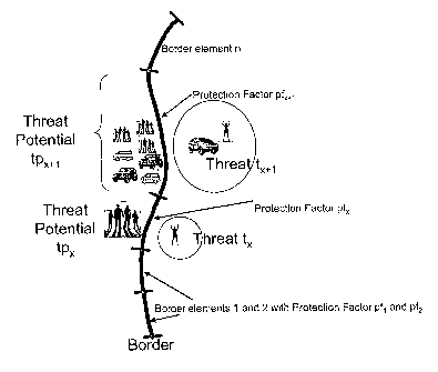
To establish a methodical approach, the border has to be broken down into
2o Elements (lengths of border) small enough to have uniform terrain features,
infrastructure and weather conditions, as illustrated in Fig. 1. This is
necessary
to be able to establish the correct threat for each part of the border.
For doing the correct splitting into elements, the following tools are needed
or
helpful:
= Good resolution topographical/vector maps of border area
= Best possible aerial pictures/satellite pictures of border area
= Preferably, also local pictures and experience from site survey along the
border
The threat itself is the result of two factors: The Threat Potential (TP) and
the
Protection Factor (PF). The TP will always have a value higher than 0 due to
such factors as differences in economy, social conditions or country location
(transit to other countries). It is important to note that the threat can be
low even
though the TP is high, due to a high PF.
The Threat Potential is a parameter expressing:
= The presence of potential border violators
CA 02662444 2009-03-03
WO 2008/044934 PCT/N02006/000350
= The type of violators including their determination to enter (e.g. work-
seeking persons, smugglers, terrorists)
The Protection Factor is a parameter expressing the existing protection of the
border:
= The difficulty of the terrain (e.g. mountains, deserts, roads, paths, woods)
= Weather (time of year, temperature, precipitation)
= The distance to villages, cities from the border (both sides)
= The infrastructure (roads, canals)
= The presence of Border Guards (deterrence)
= The presence of technical systems (deterrence)
= Less important factors dependent on local conditions
The Protection Factor is a "resistance" to the Threat Potential, deciding the
current of violators across the border at every point. This current must be
seen
as the real threat, giving:
T = TP/PF, or, since the total threat is the sum of the threat within the
small
2o elements:
n
tX
T= 1 where tx is the threat within a given element and n is the number of
elements that the border is split into. Each tx is calculated as tx= tpx/ pfx
where
tpx is the threat potential in the element area and pfx is the Protection
Factor for
the element.
In this way, the problem is reduced to finding the values of the different
factors
within each small border element where the conditions can be seen as constant
over the length of the element.
In Fig. 1 the border is segmented in a number of border elements 1-n. Each
3o border element is the object of a threat potential tp1-tp,,. tpx and tpx+l
shows the
threats posed against the border elements tx and tX+,, respectively. Various
measures are used to meet the treat potential, with the resulting protection
factors pi-p,,. The differences between the treat potentials and the
protection
factors form the treats tl-tn, which are numerical values indicating the
influx of
objects across the border.
CA 02662444 2009-03-03
WO 2008/044934 PCT/N02006/000350
Each parameter, how it is defined and determined numerically, will now be
described in further detail.
Threat Potential (TP)
The TP must be calculated to be able to find the level of the potential, which
in
turn will give the threat T when a fixed Protection Factor is used. The TP
consists of different objects such as work-seekers, organized criminals,
terrorists, trespassers. Obviously, the impact of an object from one of these
io categories crossing the border will be very different. In the calculation
of the
threat T, each category must be treated separately, or for simplicity, the
resulting TP level must be different. The last approach has been applied in
the
development of the method by using a consequence factor (c) to modify the TP
value. The factor must be high for possible terrorists and correspondingly low
for more innocent trespassers (people stepping over the border for a photo or
for excitement). The protection measures against these threats will also have
to
be different, resulting in different technical solutions during the design.
The value of the TP will therefore depend on a lot of factors such as:
= Type of object: Terrorist, activist, employee, work-seeker, other
= Class of object: Foreign or domestic, terrorist or criminal, insider
and/or outsider of the organization
= Objective of each type of object: Theft, sabotage, mass destruction
(maximum casualties), socio-political statement, other
= Number of objects expected for each category:
Individual suicide bomber, grouping or "cells" of operatives/terrorists,
gangs, other
= Target selected by objects: Critical infrastructure,
governmental buildings, national monuments, other
= Type of planning activities required to accomplish the objective: Long-
term "casing," photography, monitoring police and security patrol
patterns, other
= Most likely or "worst case" time an object could attack:
When facility/location is fully staffed, at rush hour, at night, other
= Range of object tactics: Stealth, force, deceit, combination, other
= Capabilities of object: Knowledge, motivation, skills, weapons and tools
CA 02662444 2009-03-03
WO 2008/044934 PCT/N02006/000350
These factors should ideally be taken into account when deciding the
"consequence factor" described below.
The TP for a given category can be expressed as:
tpc = f= c= WFTP and the total TP for a border element will be:
TP=Ytp~
1 , where m is the number of TP categories for the given element.
f = observed or estimated frequency of the given category in persons/day, or
io estimated frequency based on generally available information
c = consequence factor for TP category (Whole number between I and 100
representing "damage units"/person)
is WFTP = Weighting Factor for TP category (Whole number between 1 and 10,
local factor for compensating the TP value for effects from Border Guard work
pattern or similar known influences)
TP= threat potential in "damage units"/day
Protection Factor
This factor represents the "resistance" against the TP, deciding how many
border violators that are able to actually cross the border and perform their
damage (e.g. to people, to society, to economy).
The PF will be dependent on terrain, local infrastructure and technical
protection
system. A technical system may have patrols and other human elements as
part of the system. In addition, the local weather may be both an increasing
and
3o a reducing factor. Bad weather may stop objects from trying to cross border
in
difficult areas, but it is well known that professional criminals uses bad
weather
to cover illegal crossings at some locations.
For calculating the threat per element, PF needs to be calculated per element,
taking into account the abovementioned factors. A reasonable range providing
necessary resolution for the PF is 1 to 1 000 where 1 represents a fully open
CA 02662444 2009-03-03
WO 2008/044934 PCT/N02006/000350
border in simple terrain with supporting infrastructure. 1 000 represents a
practically closed border with very difficult terrain, no infrastructure and
heavy
technical protection systems. The factor due to terrain + infrastructure and
due
to technical systems is equally important for the PF, so each of these may
have
values up to 500.
PF must be calculated by using the method of splitting the border into small
elements that can be handled separately due to the need for reasonable
constant conditions:
pfx =pferra% +pf-h within a selected element with constant conditions.
Table o-1 below shows typical factors used for terrain and infrastructure that
may be used as guidelines when defining elements. Improved values must be
1s obtained through experience.
Terrain/infrastructure Factor Comments
High cliff 480
High cliff + nearby roads 400 *
Mountainous terrain 300
Mountainous + nearby 250 *
roads
Desert area 300 - 350 Dependent on size
and conditions
River 100 - 350 Depends on size
and water flow.
Lake 150 - 200
Forest 250 - 300 Dependent on type
Forest + nearby roads 200 - 250 *
Moor/swamp 150 - 200 Dependent of type
Moor/swamp + nearby 100 - 150
roads
Open fields 10 - 50
Open fields + nearby 1- 20
roads
CA 02662444 2009-03-03
WO 2008/044934 PCT/N02006/000350
Rural area 20 - 50 Dependent of type
Urban area 1- 2 This factor shall
never be less than
1.
Table 0-1: Typical PF for different terrains
* Reduce by 50 if nearby roads at both sides
For typical values for different types of technical protection systems, see
Table o-i below.
Technical system Factor Comments
Massive barrier 400 - 500 High steel or
concrete barriers with
sensors and digging
obstructions
Active fences 300 - 400 Dependent on height
and sensors
GSR and cameras 250 - 350 Dependent on
location and use of
towers
Camera chains along 200 - 300 Dependent on
border camera distance and
agility
PIR sensor chains + 170 - 270
camera chains
Long distance cameras 150 - 250 Dependent on
locations, agility and
automation
PIR sensor chains + 50 - 100 Dependant on sensor
long distance cameras type and distance.
Line sensors (cables 150 - 250 Dependent on types
and/or electronic and combinations
barriers)
Heavy patrolled border 100 - 200 Dependant on
pattern, frequency
CA 02662444 2009-03-03
WO 2008/044934 PCT/N02006/000350
and terrain
Light patrolled border 50 - 100 Dependant on pattern
and terrain
Decoys (camera, 50 - 100
radar)
Old fences & beamed 1- 10 Dependent on status
roads
No technical system 0
Table 0-1: Typical values of PF for technical systems
Using this method for each border element will enable calculation of the
threat
contribution from each element and the total threat for the border by using
the
formulas above.
Presentation of results
The threat calculation may be done using a computer system adapted to
io automatically collect all information from detectors as well as reports
from
border patrols.
The result may be presented graphically as an aid to an operator/analyst at
the
border station enabling him/her to allocate or reallocate resources in a
reliable
way. In addition, the output from the computer system may be used to sound an
is alarm when there are substantial changes in the traffic pattern at the
border.
Three main outputs of the method are Threat Potential curves, Protection
Factor curves and Threat curves. An example showing the calculated curves is
shown in Fig. 2.
2o The TP contributions from the different objects are shown with hatching in
each
bar. In this way, different countermeasures can be taken against each object
category of the TP within each element. The result of the countermeasures can
be seen on the corresponding Threat curves after calculating the PFs for the
elements. The Threat diagram will show the influence of the protection
25 countermeasures on the threat, element for element.
CA 02662444 2009-03-03
WO 2008/044934 PCT/N02006/000350
These diagrams are used in the design process of the technical system for
protection of the border. The diagrams may be used to optimize the protection
measures along the border. Ideally, the columns should be identical in height.
The data may also be used in a dynamic process for securing the borders as
explained below. One of the columns in Fig. 2 is shown I greater detail in
Fig. 3.
The height of the columns is a measure of how well this particular element of
the border is protected. The size of each individual part of the column will
tell
the boarder guards where the effort should be concentrated if the situation
must
be improved.
io These columns must be considered as snapshots of the situation since the
threat will change as soon as changes of the protection system are done. Due
to this fact, modular construction of border protection systems is required,
and
updates of the systems must be done frequently.
For an existing Border Protection system with a management system where all
incidents are treated and reported, the method can be implemented and
operate as part of the daily border protection. The system will then be a tool
for
the Border Guards for detecting and handling problem areas along the border
as soon as they appear; e.g. using BG patrols or reinforcing the technical
system.
2o A block diagram for a system that can handle the statistical data,
calculate and
present the resulting Threat potential, Threat, Protection Factor and
eventually
trend overviews (diagrams) to the operators is shown in Fig. 4.
The system includes a border management unit 45 with interfaces to various
detectors 41-44. This unit also includes a user interface allowing the border
guards to manually enter information gained during patrols along the border as
well as a display unit 410 for presenting threat curves and alarms. The border
management unit 45 is connected to a database 46 storing all incidents. A
statistics unit 47 is adapted to fetch data from the database 46.
The Statistics unit 47 extracts the number of incidents per border element and
per threat potential category (for each update) that shall be used by the
following Threat calculations unit 48 for generating overview diagrams of
threat
data and trends in the border situation development. Historical data are saved
to be able to select the time period of interest, in history database 49. The
results are returned to border management unit 45 for display or alarm.
CA 02662444 2009-03-03
WO 2008/044934 PCT/N02006/000350
The frequency of updates of the situation depends on the observed activity on
a
given border, and may vary from once a few hours to once a day. It is not
expected that more frequent updates will give any improvement since data is
dependent partly on operator handled data (reports from incidents), including
field activity to check and/or apprehend objects.
The system will be able to give alarms when threat rises above given
thresholds
to warn dedicated operators (analysts) of potential problems due to change in
behavior. Short term variations or season variations can be handled by the BG
by redefining patrol activities or modifying the technical solution (e.g. add
or
io move sensors/barriers).
Fig. 5 is a sequence diagram illustrating the steps taken in a system for
surveying and maintenance of the protection of a border. In an initial step
100,
the signals from the various sensors are received. Incidents reported by the
sensors are stored and used to calculate the instant threat situation with the
method described above, step 101. The newly calculated threat situation is
compared with historical data (the previous calculation) in step 102. If this
comparison indicates that the situation is stable, the process returns to step
100
for reading new signals from the sensors, step 103. However, if significant
changes have occurred in the threat situation, an alarm is triggered, step
104.
2o Then, various protective measures must be taken in step 105, as explained
above. The new threat situation is determined in step 106 until an optimal
border protection is achieved in step 107, i.e. the loop 105, 106, 107 will
run
until the border protection situation is satisfactory. At that stage, the
process
returns to step 100 and starts over again.
CA 02662444 2009-03-03
WO 2008/044934 PCT/N02006/000350
While the invention has been described in the context of a border protection
system covering the borders of a country, it may as well be used for the
protection of any large entity of great importance and which may be threatened
from outside. Examples of large entities that may be analyzed and protected
are
power plants, airports, dams, defence industrial sites and sites with
chemical/hazardous/nuclear waste protected by "local" border systems. The
threats in question may include air and land borne vehicles, or sea and
underwater vessels in addition to persons or groups of persons. The invention
may also be used in other settings, to protect non-physical borders, e.g. for
io determining the threat situation in a large computer network. Then,
recorded
incidents of attempted break-ins must be compared with protective measures
such as firewalls and potential risk elements such as inexperienced or inexact
users. The invention may also be used by e.g. insurance companies to
determine a threat situation, mapping recorded incidents against risk factors
and protective measures.