Note: Descriptions are shown in the official language in which they were submitted.
CA 02665179 2009-04-02
WO 2008/044042 PCT/GB2007/003880
1
Positioning System
The present invention is directed towards a positioning system for use in
electromagnetic surveying or Seabed Logging surveys and in particular for use
in
3 dimensional surveys.
Seabed Logging methods can be used to directly detect hydrocarbon reservoirs
beneath the sea floor. These methods comprise deploying an electromagnetic
source near the sea floor and measuring the response using one or more
receiver
instruments located at intervals spaced across the sea floor. The receiver
instruments may be in the form of long rigid arms carrying electrical sensors,
extending from a central body, which facilitates the detection of low-level
electrical signals in seawater. The sensors at the end of the arms are
therefore
placed near or at the sea floor.
According to one existing method, instruments are deployed as follows: the
positively buoyant instrument and an attached concrete anchor are dropped from
a
survey vessel at a chosen location; the instrument sinks freely to the sea
floor; the
position of the instrument while sinking may be monitored by acoustic methods
using one or more transponders; the instrument is positioned near to or on the
sea
floor in a desired location which is held steady by means of the concrete
anchor.
The instrument is then used to measure and store data during a survey while it
is
located on or near to the sea floor. After the measurements are complete,
acoustic
commands from the sea surface cause the instrument to be released from the
anchor; the instrument then floats up to the sea surface for retrieval by a
survey
vessel and the data is extracted from the instrument.
CA 02665179 2009-04-02
WO 2008/044042 PCT/GB2007/003880
2
More specifically, a number of different systems may be combined in use to
position a Seabed Logging source and one or more receivers prior to conducting
a
survey. These include, but are not limited to, acoustic transponders (mainly
used
for receiver positioning), magnetic compass systems (mainly used for
orientation
in the horizontal plane), depth transducers and altimeters (mainly used for
orientation in the vertical plane), tilt and pitch sensors (for spatial
orientation of
the receivers), and gyro systems (for spatial and horizontal orientation).
However,
each of these has advantages and disadvantages when seeking the accuracy of
data
required to process and interpret the detected data to provide a 3D map.
Examples
of problems typically include acoustic ambient noise, sound reflections, ray
bending and the varying sound transmission properties in salt water mainly
caused
by the variations in properties such as salinity and sea water temperature
versus
depth. This can wrongly image a target, or transponder, to be observed with a
false
offset both in range and in direction. At extreme angles, the target or
transponder
may even not be detected as it falls within a shadow zone cause by this ray
bending. The magnetic direction may also locally vary from area to area and
this
deviation may additionally change some degrees in magnetic storm conditions
and
can be complicated to detect and compensate for. The resulting measurements
can
therefore include errors which are too large for use in 3D solutions.
An example of problems is that known acoustic or electrical replying systems
for
positioning introduce external noise on the measured signals if the source is
located in the near proximity of the highly sensitive Seabed Logging sensors.
Such
noise may introduce errors in the positioning and relative orientation
measurements which may not be entirely removed during subsequent processing
of the measured data. These errors may be amplified in a 3D analysis.
CA 02665179 2009-04-02
WO 2008/044042 PCT/GB2007/003880
3
Higher degrees of accuracy in sensor positioning are required for new
acquisition
techniques, for example, 3D acquisition, as well as being desirable for
improving
the accuracy of results obtained from other processing techniques. Electric
and
magnetic fields are 3D vector dimensional and hence it is necessary to
understand
and include a full understanding of the spatial orientation of the sensors.
There is
therefore a need to improve the performance of receiver instruments, in order
to
improve the accuracy and efficiency with which surveys may be carried out and
the acquisition of data is undertaken.
It is therefore an object of the present invention to provide a positioning
system
which results in the position and orientation of the source and receivers
being
known to a degree of accuracy such that the contribution to the uncertainty in
the
measured EM field is less than 5% from all sources of error. This includes
circumstantial requirements (positional and relative timing) as well as non-
circumstantial requirements such as orientation of the sensors.
According to a first aspect of the present invention, there is provided a
passive
listening acoustic system, comprising: source means for providing continuous,
pulsed or pulse coded acoustic signals at two or more different frequencies;
and at
least two acoustic sensors or hydrophones, said acoustic sensors or
hydrophones
comprising means for detecting said acoustic signal and means for recording
the
detected signal.
In one embodiment, the system may be used to measure the position of a Seabed
Logging receiver, which is located at the sea floor. The receiver may comprise
flexible arms extending in the same plane at approximately 90 to each other.
At
the end of each arm is an electric field sensor. Associated with each of these
CA 02665179 2009-04-02
WO 2008/044042 PCT/GB2007/003880
4
sensors is an acoustic sensor or hydrophone which is located close to the
electric
field sensor. Since the exact position of each hydrophone relative to each
electric
field sensor is known, measurements from the hydrophones can be converted into
measurements for the real position and orientation of each electric field
sensor.
Accurate relative positions of the electric field sensors on each receiver to
each
other can therefore also be obtained.
The receiver may be deployed on a rigid frame which will have at least two
hydrophones secured to it such that the exact position and orientation of the
frame
can also be measured. The receiver frame may also further include magnetic
sensors. The hydrophones are preferably positioned on opposite sides of the
frame
to maximize their separation. The calculated position solution from these
measurements can supplement the readout from any other approved depth, tilt
and
pitch sensors designs which may also be fixed to the frame. Any difference
between the calculated position solution and the supplement solution may
thereafter either confirin or correct the other corresponding hydrophone
readings
on the receiver.
The acoustic signal which is transmitted has a low transducer current draw
relative
to the sensing threshold at the detecting distance and accordingly low-level
measurement signals which will not interfere with highly sensitive Seabed
Logging sensors. The EM sensors are not sensitive to such a dedicated
transmitted
acoustic signal provided that the distance between the sound source and
receiver is
sufficiently large and the sensors and/or connecting wires do not detect
adequate
movement due the acoustic shock wave. The magnetic EM sensors would
typically not be able to detect the increased current draw from a selected
acoustic
transmitter at ranges closer than about 10 meters. The EM sensors could
possibly
CA 02665179 2009-04-02
WO 2008/044042 PCT/GB2007/003880
be saturated at very close ranges but would hardly be damaged by the radiated
acoustic- or electric field alone. The source may be towed at any suitable
distance
from the sea floor, for example in the range of 5-100m, or 10-70m, or 15-50m,
for
example 15-40m or 20-30m. In other embodiments the source may be towed
5 closer to the water surface.
The receivers and/or the frame on which they are mounted may additionally
include one or more acoustic transponders. The transponders may be used to
track
the position of the receiver during deployment or during recovery and be an
acoustic link for data and/or command transfer between receivers and surface
equipment. They may also be used to activate and/or drive the release of the
receiver from the sea bottom during the recovery process.
The receivers and./or frames may additionally include one or more of depth,
tilt
and pitch sensors to enable further data to be collected and incorporated into
the
map generated.
The invention also comprises a method of accurately determining the position
of a
towed electromagnetic source and one or more electromagnetic receivers for use
in a Seabed Logging survey; the receivers including at least one acoustic
sensor or
hydrophone closely associated with each electromagnetic sensor, the method
comprising dropping each receiver into the sea water and allowing it to sink
to the
seafloor; activating a first acoustic source at a first frequency and
measuring the
position, time and movement of the first acoustic source, activating a second
acoustic source at a second frequency and measuring the position time and
movement of the second acoustic source, simultaneously recording the detected
acoustic signals on each hydrophone at both the first and second frequencies,
and
CA 02665179 2009-04-02
WO 2008/044042 PCT/GB2007/003880
6
passing the measured data to a central computer to calculate the phase
difference
and/or travel time between pairs of hydrophones.
By knowing the towing constant speed and the approximate position of the
moving vessel and the approximate position of the acoustic source at any
particular time, and the relative angles between the source and receivers, the
average source and receiver positions and orientations can be calculated by
Network solution techniques. Similar techniques have been used, for example,
for
positioning seismic vertical/bottom streamers and for localization of a target
relative to arrays of receivers on land or subsea. In the present invention,
this
technique is used to measure the orientation and position of stationary
objects
while using a moving ratller than stationary source. This will give results in
both
the horizontal plane and in the 3-D volume.
The system may further include a rigid frame for each receiver and the frame
may
include one or more additional components selected from: orientation sensors,
depth, tilt and pitch sensors, magnetic sensors and hydrophones.
The system may include one acoustic sensor or hydrophone for each electric
field
sensor, the hydrophone being located close to each electric field sensor. This
arrangement can take into account variations in the angle between sensors
which
may be caused by underwater currents or dislodging of the sensors as the
receiver
was deployed.
The method preferably utilises several phase measurements for each seabed
receiver to increase the accuracy of the positioning. The solution from this
network of phase measurements taken from multiple receivers will improve the
CA 02665179 2009-04-02
WO 2008/044042 PCT/GB2007/003880
7
accuracy. The number of measurements increases the accuracy through statistic
methods and the use of mean square analysis. The method may use a strong omni
directional acoustic source detectable at a long distance between source and
receivers. The usable range for the acoustic source signal may vary dependent
of
the survey layout and sea- and bathymetric properties. A normal usable
acoustic
range for the orientation issues will typically be between 100 meters at
closest and
ranging out to typically 1000 meters farthest off.
The source may typically be towed about 30 meters above the sea bottom. Either
one or both of the acoustic sources may be located on the same streamer
antenna
as the electromagnetic source. Both acoustic sources could be located on the
electromagnetic source streamer towed behind the vessel, one at the front tow
fish,
and the other at the rear or tail end of the towed antenna streamer.
Alternatively,
one or two of the acoustic sources may be on the one streamer and one or two
may
be on a separate source towed on a separate streamer. Each acoustic source is
recognized with individual unique source signature.
By contrast, the hydrophones are located close to the E-field sensors, i.e.
positioned onto the sea bottom. Different sound transmission properties
determine
the usable range between source and receiver. Examples:
= Bathymetry
= Sound reflections and refractions
= Source strength and attenuation
= Ray bending due to local variations in salinity and temperature, i.e.
thermoclines etc.
= Receiver signal to noise properties.
CA 02665179 2009-04-02
WO 2008/044042 PCT/GB2007/003880
8
Figure 2 shows in a schematic manner how some of the different limiting
factors
interact to produce an area where the acoustic source signal may be received.
Bathymetry and the sound cancellation effects due to reflection will introduce
a
shaded zone along the sea bottom with a survey-area dependant slope angle.
This
usable maximum distance is assumed to range out to approximately 1000 meters
if
there is a "clear" line of sight between the source and receivers elements. If
the
seafloor bathymetry is rugged or undulating, the range may be reduced
accordingly. The source strength, frequency and signal to noise ratio are also
contributing factors that determine the maximum detectable range between
source
and receiver. But, the effects of these factors can be minimized by a critical
selection of the hardware products.
Another limiting range factor is the angle between source and the pairs of
hydrophones. If the horizontal angle is higher than above a given limit (i.e.
the
source is close to the receiver), the errors in the phase angles for
orientation
measurements related to the horizontal plane are considerable. A minimum
distance for horizontal phase measurements would typically be approximately
100m for an acoustic source towed at typically 30m above the sea bottom. The
closest distance related to this error will also be counted for in the spatial
position
calculations and therefore most likely be reduced to a minimum. In fact, for a
90
horizontal angle, i.e. zero phase difference between at least one pair of
hydrophones, the position solution is within a surface plane perpendicular to
the
line between the two hydrophones. This zero phase information can preferably
be
utilized for a better position estimate at close vicinity. Overall this leads
to a given
survey dependant dough ring area (the shaded area in figure 2) around each
receiver where the source can be located while using the phase measurements to
determine the exact position and orientation of the receiver.
CA 02665179 2009-04-02
WO 2008/044042 PCT/GB2007/003880
9
The data recorded at each receiver is downloaded onboard the survey vessel
after
completion of the survey. The time stamps and phase measurements of each pair
of hydrophones are stored as part of the Seabed Logging data recorded in the
receivers. The relative positions and orientations are then subsequently
calculated
by a dedicated and proprietary navigation software package.
The present invention may be put into practice in a number of ways and some of
these will be described here in further detail with reference to the following
figures, in which:
Figure 1 shows schematically the basic set up for determining the positioning
of a
receiver;
Figure 2 shows the area around each receiver where measurements can be taken;
Figure 3 shows a receiver on a frame with pairs of hydrophones, pairs of
electrical
field sensors, triples or pairs of magnetic sensors and an acoustic (sound)
wave
propagating past the receiver;
Figure 4 shows schematically the different signals measured by the hydrophones
in a first embodiment of the phase measurement and calculation; and
Figure 5 shows schematically the different signals measured by the hydrophones
in a second embodiment of the phase measurement and calculation.
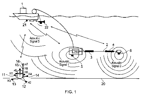
Referring to figure 1, there is shown a basic representation of the relative
positions
of a vessel 1, towing streamer 2 which includes two high current electrodes 3,
4.
The streamer also includes two acoustic sources 5, 6 which emit acoustic
signals at
different frequencies and/or pulse shapes, here named acoustic signal 1 and
acoustic signal 2. The vessel could alternatively tow more than one streamer
with
the electrodes or acoustic sources on them (not shown). A receiver 10 is
positioned
CA 02665179 2009-04-02
WO 2008/044042 PCT/GB2007/003880
on a frame and has been dropped to the sea floor 20. The receiver has in
principle
four electric field sensors 11, 12, 13, 14 arranged substantially orthogonally
in
substantially the same plane. The receiver may also have in principle other
pairs of
electric field sensors 15,16 arranged substantially in the vertical plane.
Each
5 sensor 11, 12, 13, 14, 15, 16 has a hydrophone H1, H2, H3, H4, H7, H8
respectively associated with it. The frame may also have numbers of pairs of
hydrophones H5, H6 arranged on opposite sides of the frame (see figure 3).
Other
types of sensors may be located inside the frame related to the orientation of
the
frame. These are typically magnetic field sensors and depth sensors and tilt
and
10 pitch sensors and are shown as 17, 18, 19 in figure 3.
The vessel may have an Ultra Short Base Line (USBL) transponder 21 fitted to
the
bottom of the vessel to measure the position of the electromagnetic streamer,
both
the front end and the tail. The vessel may additionally have a further
transmitter 22
with acoustic signal 3 which may be used to measure the vessel 1 position
relative
to the receiver 10. This additional transmitter may be either hull mounted
(not
shown) or towed separately from the electromagnetic streamer as shown in
figure
1. In this case the towed transmitter may be positioned relative to the vessel
by the
USBL transponder 21.
As described above, figure 2 shows the preferred area around each receiver
within
which measurements can optimally be taken. The precise formation of the area
will vary from survey to survey as it is affected by variables such as source
strength and attenuation, local variations in salinity and temperature, sound
reflections, etc. However, many of these variables will be known and the
preferred
area can be selected by navigation processing software given the actual towing
CA 02665179 2009-04-02
WO 2008/044042 PCT/GB2007/003880
11
source altitude such that data as recorded at each hydrophone, accurately
determines the position of each receiver and each sensor on each receiver.
Figure 3 shows a top view of receiver 10 mounted on a frame 25. The receiver
comprises flexible arms 30, 31 on which are mounted electric field sensors.
The
arms are arranged to extend substantially orthogonally to each other within
the
same plane. However, this cannot be assured after the receiver has dropped to
the
sea floor and angles may therefore vary slightly as shown in figure 3.
Therefore,
there are hydrophones H1, H2, H3, H4 associated with each sensor 11, 12, 13,
14
to measure the acoustic signals received at a position adjacent to the sensor.
The frame 25 also has hydrophones H5, H6 mounted at opposite sides. This is to
measure the orientation of the receiver once it has settled on the sea floor.
For
theoretical modeling, it is normally assumed that the sea floor is
substantially flat
and that the receivers will therefore lie such that the sensors are all in the
same
horizontal plane. In practice this will not be the case and hydrophones H5 and
H6
determine the horizontal orientation of the frame and hence also of the
sensors that
are located/fixed onto the frame. Hydrophones H7 and H8 may additionally be
mounted vertically relative each other on the frame or onto a vertical pole
attached
to the frame to determine the spatial orientation. One example of vertical
mounting H7 and H8 is shown in figure 1. Figure 3 also shows the acoustic or
sound waves being propagated in the direction of arrow 40 and the phase
difference between two hydrophones H3 and H4 by means of arrow 50.
Described below are two embodiments for the method of analyzing and using the
data to measure the phase between pairs of hydrophone signals. Figure 4 shows
CA 02665179 2009-04-02
WO 2008/044042 PCT/GB2007/003880
12
schematically the different signals received by a pair of hydrophones
according to
a first embodiment of the present invention.
According to the first embodiment, each of the two or alternatively three
acoustic
source signals is a continuous amplitude modulated mono frequency, also known
as an AM-signal. Refer to acoustic signal 1, signal 2 and signal 3 in figure
1. An
AM signal is designed by two frequencies, i.e. the modulated frequency with
the
information of interest and a carrier frequency usable for the transmitting
medium.
The selection of the carrier frequencies are given by the propagation of sound
in
sea water and the best selection of corresponding transceivers and receivers
for the
actual water depths and typically frequencies ranging between 12kHz to 50 kHz.
The selection of frequencies shall not interfere with the other survey subsea
communications, such as for example USBL positioning commands, altimeters
and echo sounders. The maximum wavelength of the modulated frequencies in the
present invention is defined as the half wavelength which equals the distance
between named pairs of hydrophones. For example, for 8 metre sensor arm
'length
and using the sound of speed, in water as 1500m/s, the maximum modulated
frequency is about 100Hz. The true speed of sound close to the sea bottom can
be
measured and counted for in the calculations.
The acoustic sources and pairs of hydrophone receivers can be associated with
the
following AM-radio transmitter/receiver similarity. Each of the acoustic
sources is
a broadcast AM transmitter tuned for sending 100Hz humming signals. Each of
the hydrophones is a AM radio antenna. A pair of hydrophones makes an
receivers
directional dipole antenna. All the electronics after the hydrophones are
individual
radio receivers tuned to listen for individual programs and hence capable to
filter
out all other AM-modulated broadcasted signals.
CA 02665179 2009-04-02
WO 2008/044042 PCT/GB2007/003880
13
The hydrophones measure all the individual frequency carrier signals as they
continuously arrive at the hydrophones. The signals are then conditioned by
individual charge amplifiers and further sent to the individual bandpass
filters. The
filters are designed so that only one carrier frequency can pass through each
bandpass filter The bandpass filtered signal is then sent through low-pass
filters
so that only the low frequency of about 100Hz is passing through. By this
method
each comparing phase circuitry will only detect the signal from only one of
the
designated acoustic source transmitters. Each of the pairs of two hydrophone
signals can be subsequently compared in an off the shelf electronic circuitry
where
the phase difference is output as an analog signal scaled as V/degree. These
analog
output signals can either be measured directly onto analog input channels on
the
subsea data logger on the Seabed Logger receivers or preferably be digitized
onto
a separate electronic circuitry and the phase difference results be finally
exported
in selected real time intervals to the datalogger as digital values and stored
as a
part of the recorded time-stamped Seabed Logging data.
Figure 5 shows schematically a second embodiment of the present invention for
measuring the phase between a pair of hydrophones. In this embodiment, the
different source signals may consist of any type of signal as long as they
differ
from each other and the signal can be detected over the required range and
preferably knowing their original transmitted signal shape and the duration is
known. The figure shows one example of two applicable signals that is
constructed of one up-sweep and the other of one down sweep, also called
"chirp-
signals", with sufficient duty cycle each from an individual source - acoustic
sources 5,6 in figure 1. The signal will in this application typically sweep
though
all frequencies ranging between 15-25kHz over a time period of 5 seconds. The
CA 02665179 2009-04-02
WO 2008/044042 PCT/GB2007/003880
14
signal can also be composed of single pulses or other different coded type
signals
like "spread spectrum" or "phase shifted code" known from wideband
transmission technologies.
The selection of the transmitted frequencies are again given by the
propagation of
sound in sea water and the best selection of corresponding transceivers and
receivers for the actual water depths and typically frequencies ranging
between
12kHz to 50 kHz. The qualified selection of coded signal ranging over a
variety of
frequencies will under normal conditions not interfere with the other survey
subsea communications, such as for example USBL positioning commands,
altimeters and echo sounders After measuring the signals at the hydrophones
the
signals are again conditioned by individual charge amplifiers and detected by
a
"digital signal processor" (DSP) with ready integrated analog-to digital
converters.
The DSP is programmed to calculate the cross-correlation between the different
hydrophone signals. The time difference between the two maximum outputs from
the cross-correlation is a direct measure of the relative arrival times or the
direct
phase difference by knowing the velocity of sound traveling between the
hydrophones. The results are exported in selected real time intervals to the
data
logger as digital values and stored as a part of the recorded time-stamped
Seabed
Logging data
This DSP method has the advantage that all combinations between phase
differences and/or relative arrival times between multiple numbers of pairs of
hydrophones can be calculated inside one chip. This makes subsequent
electronics
smaller, with less power consumption and making the processing to form the 3-D
volume of the area being surveyed easier.
CA 02665179 2009-04-02
WO 2008/044042 PCT/GB2007/003880
The present invention provides apparatus and a method for accurately
determining
the relative positions of vessel, electromagnetic source and receivers in the
same
time frame and thereby enabling the determination of a 3-D volume of the area
being surveyed to be drawn up after the results of the EM survey have been
5 analysed. The apparatus and method of the present invention does not damage
the
sensitive sensor equipment used in Seabed Logging surveys and also allows the
position of the receiver to be measured at the same time as the
electromagnetic
signals are being transmitted and received by the sensors - i.e. in a single
pass.
10 For an accurate 3-D volume to be determined it is necessary to have
accurate
positioning of both source and receiver. The invention determines the relative
positions and geometry of vessel, electromagnetic source and receivers in the
same
time frame. The relative positions are tied to the true position world
coordinates by
surface vessel positioning such as by "Global Positioning System". GPS
satellites
15 are commonly used references today. A selection of two or more sea bottom
receivers can additionally be positioned more accurately by other standard
surveying methods as for example triangulation and vessel spin on top of each
selected receiver to cancel out misalignment and USBL positioning errors. This
is
normally a time consuming process and inappropriate if many receivers deployed
on a survey area. But, knowing the more exact position of a few receivers will
help improving to tie the relative network positions to the true position
world
coordinates.
For a Seabed Logging source, the uncertainty of the source orientation angles
should be less than 2 degrees. For example, if the antenna length is 300
meters,
this means that the relative positions of head and tail of the antenna should
be
known within 15 meters. The uncertainty of the timing should be less than 4 ms
in
CA 02665179 2009-04-02
WO 2008/044042 PCT/GB2007/003880
16
order to produce correct phase. In order to produce correct amplitudes the
drift in
timing is required to be less than 1 ms.
The uncertainty of the source position parallel to the seafloor should be less
than
13 meters. The uncertainty in source depth should be less than 7.5 meters. The
uncertainty of the source elevation should be less than 7.5 meters and the
uncertainty of the source length should be less than 5 percent. The
uncertainty of
the source current should be less than 5 percent and finally the relative
standard
deviation of the source should be less than 0.02.
There are similarly high requirements for each of the Seabed Logging
receivers.
The uncertainty of orientation angles of the receivers should be less than 2
degrees. The uncertainty of the timing should again be less than 4 ms in order
to
produce correct phase, and in order to produce correct amplitudes versus
offsets,
the drift in timing is required to be less than lms. The uncertainty of the
receiver
position should be less than 13 meters in horizontal direction and less than
7.5
meters in depth. The uncertainty of the electrode distances should be less
than 5
percent (40 cm with 8 meters nominal electrode separation).
By determining the positions of the electromagnetic source and receivers to
such
accuracy it is possible to determine the 3-D volume for the area being
surveyed. In
particular, the apparatus and method of the present invention provide
measurements which meet the requirement that the contribution to uncertainty
in
the measured electromagnetic field should be less than five percent from all
sources of error.