Note: Descriptions are shown in the official language in which they were submitted.
CA 02667711 2009-05-29
APPARATUS AND METHOD FOR TRANSIT PREDICTION
BACKGROUND OF THE INVENTION
=
1. Field of the Invention
The present invention relates to devices and methods for offering navigational
choices, or preferences.
2. Description of the Related Art
Traffic flow can benefit from the availability of enhanced information in a
traffic
signal environment. This can be in either a traffic signal environment or a
traffic sign
environment, or a combination of both.
Present navigation systems permit latitude, longitude, latitude/longitude,
latitude/longitude/altitude, rho/theta, rho, theta as well as, a plethora of
combinations of
. ,
=
these and other reconciliatory methods for offering positional and/or velocity
and/or
acceleration, and/or jerk information. Common navigational arrangements
include: use of a
map display, some of which are moving map displays, some of which are supplied
with
navigational information from a GPS receiver. In this disclosure, it is
understood that
enhanced techniques such as differential UPS, or the use of pseudolites (i.e.
ground elements
complementing or replacing the space borne constellation of satellites) are to
optionally
stand in for the primary elements, i.e. GPSS, the satellites or a combination
thereof
According to Webster's Ninth New Collegiate Dictionary (1989), a histogram is
"a
representation of a frequency distribution by means of rectangles whose widths
represent
class intervals and whose heights represent corresponding frequencies." In
this
specification, for three dimensional histogram representations, the rectangles
have a width
representing class intervals of position along a traffic path in
latitude/longitude space and a
width representing class intervals along a line of a latitude/longitude
combination, other than
collinear with the length representation and whose heights represent frequency
of
occurrence.
=
1
=
=
. ,
CA 02667711 2009-05-29
See also U.S. Patents 4,559,602; 5,371,678; 5,636,128; 5,911,773; 5,940,010;
6,125,105; 6,317,686; 6,338,021; 6,385,537; 7,054,742; 5,986,575; and
6,243,026; and U.S.
Patent application 2006/0055557. See also Bell and MacDonald, "Bus Recognition
and
Prediction," Student Final Project CS4721, Columbia University, May 13, 1999.
SUMMARY OF THE INVENTION
In accordance with a first aspect of the present invention, there is provided
a transit
predictor to be carried by a carrier such as a person or vehicle when
attempting to travel
through one or more traffic signals that have a repeating change of state. The
transit
predictor has a data source with a navigational output indicating carrier
location and a timing
output indicating time. The transit predictor also has a processor with a
memory. The
processor is coupled to the data source for recording in the memory a
plurality of
background data from the data source signifying (a) one or more carrier
locations where data
from the data source indicate the Carrier was substantially stationary, and
(b) one or more
times when data from the data source indicate the carrier ceased being
substantially
stationary. The processor is operable to algorithmically derive from the
plurality of
background data a predicted future event that will occur around a predicted
time at a
location where, according to the background data, the earner previously ceased
being
substantially stationary.
In accordance with another aspect of the invention a predictive method is
provided
that employs a memory for use with a carrier such as a person or vehicle when
attempting to
travel through one or more traffic signals that have a repeating change of
state. The method
includes the steps of recurrently providing a navigational output indicating
carrier location =
and recurrently providing a timing output indicating time. Another step is,
using the
navigational and the timing outputs, recording in the memory a plurality of
background data
signifying (a) one or more carrier locations where the carrier was
substantially stationary,
and (b) one or more times when the carrier ceased being substantially
stationary. The
method also includes the step of algorithmically deriving from the plurality
of background
2
,
CA 02667711 2009-05-29
=
data a predicted future event that will occur around a predicted time at a
location where,
according to the background data, the carrier previously ceased being
substantially
= stationary.
A disclosed device can enhance navigation by augmenting the outputs of a
navigational sensor system. The device has at least one sensor for determining
at least one
of: a line of position, a velocity, a position in two or three dimensions. The
navigational
sensor is used in conjunction with a timing mechanism, and a processor to
deduce at least
one of: when the user is not in motion, when the user is in motion; using the
timing
mechanism to predict the phases of traffic lights and presenting this
information to the user
in audible, visible or a combination of both formats. The displayed
information can include
at least one of: zones of synchronized traffic lights, multiple fields
overlaid synchronized
states of traffic lights indicated by arrows or the like on underlying moving
maps, and the
amount of time remaining before a state change (red to green, green to
yellow/red), the
inability to resolve the traffic light state with available information, or
the partial inability to
resolve the traffic light state with available information.
In a disclosed method information is provided in a more readily usable format.
This
method also includes the steps of extracting the information from a database.
Also ongoing, interlaced with the detection and recording of locations of
stoppages is
the extrapolation of potential positions (optionally taken from a database of
validated routes)
and continual comparisons of the present position to a position extrapolated
ahead. This
extrapolated position can be obtained for various amounts of time, 10, 20, 30,
40, 50
seconds, and so on up to so many minutes. All the predicted positions can be
compared to
locations in the database that are stored (and to a minor extent being stored)
in memory. If
the system determines that a predicted position is within some threshold of
being at a
previously recorded location of stoppage (i.e. a previously visited
intersection), the time at
which the vehicle will arrive there is also predicted. This can be further
refined by an
ongoing interpolation as well. For example refinements of position can be
interpolated fin
known regular locations e.g. repetitive blocks, arrays, or intersections.
Also, knowledge of
3
=
CA 02667711 2009-05-29
intersections on either side of an intersection being approached or waited at,
can be
interpolated and presented to the user.
The system accumulates many qualified data sets. The many data sets are
compared
on a day-to-day basis, an every second day basis, and an every nth day basis.
Examples of
these data sets are presupposed patterns such as rush hours, time of weekdays,
known
resynchronizations, known intervention systems from e.g., EMS, neighborhood
boundaries,
occupied lanes, holidays, etc., and combinations of such. All such data sets,
which can be
extrapolated onto a reference date, are used to make predictions of the times
at which a
traffic light will turn green, for a given day. These predictions are
displayed on a moving
map display, or added to the data stream from a navigational sensor to such a
moving map
display, externally or integral to the unit.
A further refinement of this basic method extracts all locations of stoppage
in the
non-volatile memory and determines which, if any are the furthest forward
location in the
direction of travel, which is given a temporary assignment of being "at the
stop line."
Another embodiment includes the steps of extracting the information from a
database
augmented with data from other sources. More specifically the adjunct device
for a Global
=
Positioning System integrates information obtained, using at least one rule in
a rule based
expert system using time as the primary driver for decision information.
The system exploits at least one of: the synchronicity of traffic patterns
derived
primarily from estimates of traffic, inputs from previous traffic patterns,
time of day, day of
week, a histogram of findings of traffic congestion, traffic stoppage,
distance from traffic
signaling elements, previous traffic signal state, traffic signal state,
anticipated traffic signal
states.
The data stream leaving the navigational sensor is sensed and compared to the
previous value. At the paint that the vehicle's position is determined to be
moving, the time,
the latitude and the longitude and optionally the direction of arrival are
stored in a database.
The data are filtered by location and optionally direction of arrival to
determine the points in
time that the sensor has re-commenced motion at substantially the same
location
4
=
,
¨ =
CA 02667711 2009-05-29
(intersection). By filtering and comparing all known re-commencements a
histogram versus
time for suitably close locations can be made. In this way likely
possibilities for
re-commencement can be extrapolated and from this set a suitably close into
the future and
suitably close in position (i,e, where you are about to be, and when you are
about to arrive
there in time) predictions can be made.
By suitable communication of this information to the user, by at least one of
display,
lights, annunciation, tone output, steering inputs, suggested steering inputs,
other vehicle
inputs, e.g., turn signals, moving map overlay, optionally via a data link,
optionally the
Internet, the user can make informed decisions on muting, optionally done by
automated
means.
By employing devices and methods of the foregoing type, a party can
effectively
increase the party's understanding of the timing, or at least use thereof; of
traffic lights.
In another embodiment the information is added as a color on a moving map
display.
In this embodiment a moving map display has colored overlay in red, green,
yellow
indicating preferred routes, optionally these routes are from a set of
commonly used routes
determined by sensing the position of the sensor habitually. This can be
filtered by time of
day by time of week.
In another embodiment a sense of position in phase with where the user is in a
synchronized traffic system is relayed to the user. It is understood that
partial information
can also be supplied, i.e. cross street vehicle sensing pads can arrest
otherwise main traffic
flow but only during certain traffic light phases.
In another embodiment the navigation sensing element, combined with other
sensor
elements is Kalman filtered to create a navigational solution, passed to the
using entity.
Kalman filters as applied to navigation can use supplementary sensor
information to enhance
reliability of estimates of position offered by certain types of sensors (i.e.
if GPS is not
available then wheel spin and direction is acceptable for a short time, or the
like).
In another embodiment the system learns over long periods of time preferred
routes.
In another embodiment the system compares current locations to estimated
locations
5
¨
CA 02667711 2009-05-29
of intersections; i.e. it compares all similar locations with the same
direction of arrival and
estimates the furthest forward stopping location (determines the location of
the "white
stopping line" at the periphery of the intersection) and initially filters all
known stops in the
area, (optionally of the same direction of arrival) and uses the ones that are
furthest forward.
In another embodiment the system uses the furthest forward information and
slightly
further back information with a lesser weighting function, optionally with a
predetermined
time value dependent on position of stop from the estimated location of the
intersection; i.e. =
it makes an estimate of whether the vehicle is the first in line the second in
line, the third etc.
and then uses a predetermined estimates (perhaps from running average) of the
time that the
traffic between the user and the intersection takes to get moving after the
light has turned
green. The weighting function falls off pretty quickly as the traffic ahead of
a stopped user
could have a large variation in response times to a green light and the system
gives better
results provided the more refined data is used with greater weighting values;
i.e. use all
values determined, but water down the values of stoppages unless right at the
line.
In another embodiment of the present disclosure all known similar location
stoppages (i.e. all stops in all different directions at the same
intersection) can be used for
estimates of the time at which the light must have turned red; i.e. use up all
of the available
duty cycle. (Assumptions about substantially opposite directions of arrival
permitted the
same green time slot can be made.) Additionally it is envisioned that the user
can add
additional information such as "light that just turned green simultaneously
permits left
turns" to augment the database in such fashion. In an embodiment of the
present disclosure =
information refined by such is used in such refined fashion for the other
aspects of the
disclosed system; i.e. once the information is refined and has available the
light sequences,
that information can be used in the display, annunciations, etc. It can also
be accumulated by
the expert system by suppositions of time.
In another embodiment of this invention the aforementioned device is coupled
to the
output of a conventional OPS system, including the time signal, and is
displayed as a set of
colour tracings overlaid on a moving map display, wherein the colour is an
indication of the
6
CA 02667711 2009-05-29
likelihood of better than average passage possibility.
PRIEF DESCRIPTION OF THE DRAWINOA
The above description as well as other objects, features, and advantages of
the
present invention will be more fully appreciated by reference to the following
detailed
description of presently preferred but nonetheless illustrative embodiments in
accordance
with the present invention when taken in conjunction with the accompanying
drawings,
wherein:
Figure 1 is a schematic block diagram of a device of a first embodiment in
accordance with principles of the present invention;
Figure 2 is a perspective view of the device of figure 1 packaged as a global
positioning system as the navigational sensor, with an auxiliary device as an
attachment;
Figure 3 is a histogram showing one form of organization of the data collected
from
the device of Figure 1;
Figure 4 the histogram of Figure 3 after positional filtering.
Figure 515 a diagram representing traffic signal phasing on separate time
lines;
Figure 6 is an informational flowchart showing operations performed by the
device
=
of Figure 1;
,t
Figures 7A and 7B are informational flowcharts supplementing that of Figure 6
and
further showing operations performed by the device of Figure 1;
Figure 8 is a diagram representing traffic signal phasing on separate time
lines and
marked with certain attempted intersection crossings;
Figure 9 is a flowchart illustrating a power down processing for the device of
Figure
I;
Figure 9B is a schematic block diagram of a circuit that may be used in
connection
with the device of Figurel;
Figure 10 is an information display developed by the device of Figure 1 in the
form
of a map overlaid with the color information at the intersections;
7
CA 02667711 2009-05-29
Figure 11 is an information display that is an alternate to that of Figure 10;
Figure 12 shows an information display that is an alternate to that of Figures
10 and
11 and that is overlaid with zones of synchronization; and
Figure 13 shows a moving map of Figure 12 but modified to show moving zones of
synchronization,
DETAILED DESCRIPTION_OF THE PREFERRED EMBODIMENTS
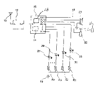
Referring to Figure 1, a transit predictor is illustrated according to a first
embodiment
as a device for offering enhanced navigational information. This transit
predictor may be
carried by a carrier such as a vehicle or a person and employs a navigational
sensor 12
providing a navigation output indicating carrier location. Navigation sensor
antenna 10
sends signals to input IN of navigation sensor 12. Navigation sensor 12 is in
this
embodiment a GPS system with a navigation output OUT connected to input IN of
processor
16. Sensor 12 outputs GI'S data streams of any one of various types including
NMEA =
(National Marine Electronics Association), whereby the time information is
readily
available. Instead of conventional GPS, some embodiments may use the GALILEO
(European) navigation system, the GLONASS (Russian) navigation system, or the
Baidu
(Chinese) navigation system. In other embodiments of this invention the
navigation sensor
may use exclusively or supplementally inertial navigation to determine
positional
information. Still other embodiments may provide navigational output from one
or more of
an inertial navigational reference, a LORAN sensor, an Omega navigation system
sensor,
and an RNAV receiver.
In still other embodiments the navigational sensor may employ a cellphone
device
that supplies navigational information from cellphone infrastructure. In such
cases the
system may determine location by triangulation from cell towers, or by using a
directional
antenna.
Processor 16 has memory 14, which includes volatile and nonvolatile digital
memory
and can accumulate triples of latitude, longitude and time. The foregoing
equipment may be
8
=
¨
CA 02667711 2009-05-29
carried in a vehicle, for example, an automobile. In this disclosure the
apparatus is
self-contained and battery operated.
Processor 16 receives time information either as a timing output from sensor
12 or
from another timing device. For example, processor can have its own internal
clock or can
be connected to a second device such as some other external clock. The devices
providing
the navigation output and the timing output are collectively referred to as a
data source.
Processor 16 is shown having a two-dimensional LCD display 18, herein referred
to =
as an interface. In some embodiments display 18 may be a separate display
connected to
processor 16.
As described further hereinafter, navigational sensor 12 detects the location,
and by
biking the difference in a minimum of two different locations can deduce an
approximation
of velocity. This is an ongoing activity monitored or implemented by processor
16. The
system can declare that velocities below a certain magnitude are effectively
zero velocity
(except that some changes may be treated as small distance increments that are
an artifact of
update and truncation errors occurring post-stoppage). The system will record
in
non-volatile memory 14 the time of occurrence, the location, and the direction
of arrival (i.e.
the sign of the difference in position, which was calculated and used to
approximate
velocity). Recorded data can be referred to a stopping event (stoppage) and
can be
correlated to the place and time when a vehicle (carrier) first stopped and
when it next
moved.
Output OUT1 of processor 16 may be connected to a display as described further
N. Network
NPmcac:sbseoranouinfonnatputs 00UoTn2chalOelUToplonnecb.3t,
tthocoangeentermincy inalc..hargof loeuodfspeaker 20
(other terminal grounded) and to transmitter/antenna combination 22, acting as
a wireless
transceiver to/from a remote network.
This wireless transceiver 22 can establish communications with an external
network
maintaining traffic signals. Network N can instead be a network of vehicles
carrying
equipment similar to that described herein. Network N can be accessed in order
to
9
CA 02667711 2009-05-29
download at least one of (a) supplementary data that can be used to supplement
background
data stored in memory 14, and (b) a schedule of state changes for one or more
traffic signals.
Transceiver 22 can also upload to this network N at least one of (a) time and
location of
events predicted by processor 16, (b) at least a portion of the background
data of memory 14,
and (c) information derived from the background data.
Processor outputs OUT4 through OUTn connect to the anodes of LEDs 33, 31, 29,
...
27, whose cathodes connect to ground through resistors R1, R2, R3, ... Mi. In
some
embodiments these LEDs can signal the state or predicted state of certain
traffic signals.
Referring to Figure 2, previously mentioned navigation sensor (sensor 12 of
Figure
1) is contained within navigation sensor module 120. Module 120 is shown with
an
interface in the form of keyboard 124 and LCD display 121. In SOIlle
embodiments
keyboard 124 may be used as a user operable device enabling a user to signal
observations to
the processor (processor 16 of Figure 1). Module 120 has a data port 122,
which is adapted
to connect to adjunct enc1osure126 containing the previously mentioned
processor
(processor 16 of Figure 1).
Figure 9B is a schematic block diagram showing the components of the power
down
circuitry. Main circuitry 510 (previously shown in Figure 1) is shown here
with volatile
memory 514, and non-volatile memory (NVM) 512 (also referred to herein as a
volatile and
non-volatile section of a memory). External power supply potential +V is
connected to the
anode of rectifier CR1 whose cathode connects to terminal PWR of main circuit
510. The
positive and negative terminals of optional battery BI or connected to
terminals PWR and
OND, respectively, of main circuit 510. Optional capacitor Cl is connected in
parallel with
battery Bl. At least one of Cl or 131 or an alternative power source must be
present to
supply internal power.
Serially connected resistors RI and 1W form a resistor divider that is
connected =
across battery Bl. Serial resistors R2 and R3 are connected between terminals
PWR and
GND of main circuit 510 to form another resistor divider.
The junction of resistor divider Rl/R4 is connected to one input of comparator
516
CA 02667711 2009-05-29
=
whose other input connects to the junction of divider R2/R3 in order to act as
a power
sensor. The output of comparator 516 connects to terminal INPUT of main
circuit 510.
As explained further hereinafter the dividers provide an indication of voltage
levels
that are suitable for processing on the rail voltages V+, or those of Cl or
Bl. =
Before removal of potential +V (i.e., during normal use) the resistor divider
R2/R3 is
powered by the external power +V and resistor divider RI/R4 is powered along
with all
other circuitry by V+ via diode CR1 in positive bias. The nodes in the middle
of the R2/R3
resistor divider and the Rl/R4 resistor divider are input to comparator 516
which in turn
detects that node R2/R3 is at a higher voltage than node Itlat4.
=
Removal of external power V+, reverse biases diode CR1, and in turn removes
=10 power to the resistor divider R2/R3 and causes the remaining circuity
to be powered by the
internal power source, battery Bl in our example. Removal of power to resistor
divider
R2/0.3 causes voltage at node R2/R3 to be less than voltage at node R1/R4,
which in turn is
,
sensed by comparator 516 to provide a signal to terminal INPUT of main circuit
510 (i.e.
providing a signal to processor 16 of Figure 1).
=
Main circuit 510 detects this power down and, as described later in connection
with
Figure 9, writes RAM contents 514 to NVM 512. Energy in capacitor Cl, or
battery Bl, is
sufficient to completely support this storage process.
Restoration of external power +V, restores power to resistor divider R2/R3,
and the
remaining circuity via now positively biased diode CR1. Restoration of power
to the
resistor divider R2/R3 causes the voltage of the R2/R.3 node to be higher than
the voltage at
the RI/R4 node, which is in turn sensed by comparator 516, sending a
corresponding signal
, to niain circuit 510,
This comparator signal supplied to the main circuit 510 causes the contents of
the
NVM 512 to be written to RAM 514 for use until the power is removed at V+ once
again.
Figure 9 is a diagram showing the sequence of actions that the present
device/method
uses. In Figure 9 power down action is triggered by removal of the incoming
electrical
power.
11
CA 02667711 2009-05-29
=
After removal of the vehicle power, V+, the first step of Figure 9 detects the
power
loss, and initiates the shut down sequence. In our example, circuitry 510 is
powered by the
internal battery B1 (Figure 9B) and uses random access memory, (RAM) memory
514 for
memory storage needs of Figures 6, 7A, and 78, for example step S33, or step
S28.
hi this example the RAM is easier to access and use, whilst the NVM doesn't
require
power during the interval that the unit is completely powered down.
Once data has been written to NVM, the unit completely shuts down.
Figure 3 shows a histogram developed from an exemplary database containing
records of events where a carrier (vehicle) stopped at an intersection. In
this context, a
histogram is defined to mean a representation of a frequency distribution by
means of
rectangles with a bottom edge whose placement is a linear representation of a
latitude/longitude combination. The height of these rectangles represent
frequency of
occurrence.
The histogram structure can be a three-dimensional array with an array of time
of
day, and day associated with the structure. The device of Figure 1 can detect
and store
repetitive stopping locations using latitude/longitude and the time of
stoppage for each of
=
stops 212, 214 and 216. (The device of Figure 1 can start with either present
position,
expected position, direction of travel, and compare it to the objects in the
structure of Figure
3.)
This example is for a very sparsely populated area with the vehicle stopping
frequently at the various stop lines 212, that is, stopping at a traffic light
without any
intervening vehicles ahead. A moderate amount of the stopping events occur at
(a) location
214, one car length back from the traffic signal, and (b) occasionally at
location 216, two car
lengths back. The heights of upright rectangles at locations 212, 214, and 216
are sized in
proportion to the frequency of the stopping events. It is understood that
other locations
further back from the line can be used as well, optionally in conjunction with
the
aforementioned cases 212, 214, and 216.
Figure 4 shows a histogram filtered to leave only stoppages at the stop line.
12
CA 02667711 2009-05-29
Because vehicle lengths are different, the histograms for line locations 214,
214 of
Figure 3, are not as sharp as illustrated (i.e., they might appear more like a
sloping ridge than
a sharp plane or wall). Location 216 represents two vehicle lengths back and
consequently
will tend to be less sharp. For this reason less weight (a predetermined
criteria f-or lowering
the reliability rating) may be given to data associated with stop locations
214 and 216.
The data accumulated into this histogram includes the time of any stopping
event in
the close vicinity of a traffic light and then evaluates whether stopping
events are closely
related in time and space. If so related the processor 16 of Figure 1
calculates the best
estimate of the time and location for the stopping event for the purposes to
be described
hereinafter. In building this histogram, GPS offers both a highly accurate
clock and
re-synchronized if required, as well as, a somewhat refined indication of
position. The
system can use best guess information and makes the guess to the best of its
capability, or
using best information from a plurality of data sources.
Once a correlation is made, the set of accumulated data from previous
stoppages at
that location is ordered (i.e. last time, second last time, third last time
etc.) and extrapolated,
with the last entry being weighted the most. A prediction of when the traffic
signal becomes
a given condition (e.g. a green light) for this particular direction of
travel, is developed by
determining the experience from previous instances and deduces what the
interval between
the turnings green is.
As a simple example, for a given traffic light which turned green at 8:24:00
A.M. on
Monday and again on Wednesday at 8:24:30 A.M., a prediction of when that light
will turn
green again Thursday will be 8:24:45. A subsequent measurement of the light
turning green
8:25:45 A.M. on Thursday (but not the 8:24:45) suggests that the light may
cycle on one
minute intervals. Accordingly, with the foregoing data, then the set of
predictions for Friday
include 8:26:00 (8:25:45+15 sec), 8:27:00, 8:28:00, 8:29:00, 8:30:00, etc.
Moreover, the
light is predicted to be red for a certain number of seconds before each of
those times in that
given travel direction.
Lights are assumed to be pure signals (i.e. no arrows, or advanced or delayed
greens)
13
CA 02667711 2009-05-29
at first, but may be refined as the user uses manual controls to supplement
event data,
effectively teaching the device that the signal at this location has alternate
paths, e.g. green at
a different phase that permits left turns. Alternatively, the user teaches the
system the exact
position of a stop line as he/she passes it, or indicates anomalous activity
and to 'forget
previous.'
Stops at some intersections will have been too infrequent to accurately
predict future
time of stoppage and one may need to wait for a build-up of stoppage data.
Further data
collection will permit corroboration and enhance the predictive powers of the
system, If the
said prediction is corroborated and reliable this fact can be displayed,
annunciated,
forwarded to a network or otherwise used. The absence of such a reliability
rating suggests
the unsuitability of such data and predictions. The reliability can be
indicated by a
non-standard color, such as blue in a graphical display. In some cases the
level of reliability
can be indicated by saturating a color or by increasing the volume of an
audible
announcement. In some cases, the exact time of turning green (i.e. present
intersection) is
removed a few seconds prior to prevent users from 'running the light.'
Figure 5 represents traffic light sequences around the same time of day as
five arcs
representing five successive days (labeled as Monday, Tuesday, Wednesday,
etc_). The
representation shows the state times of a traffic light as a time-line
position along the arcs. In
the example, red lights are represented by R, green lights are represented by
G, and yellow
or amber lights are represented by Y. Arrivals at a given intersection are
shown as 'X's
followed by a line terminating in an arrowhead at the actual time of crossing.
For Monday the arrival marked X occurs at an amber light and is too late to
allow
immediate passage. The reference phase 300 indicates the occurrence of the
next available
red to green transition. For Tuesday the red to green transition occurring
most closely to the
same time of day is marked as reference phase 302. Note this phasing is not
known a priori
and may have yet to be determined. Similarly, the closest red to green
transition on
Wednesday is marked as reference 304. Again this phasing is not know a priori
and may
have to be determined, The day to day timing drift or phase from reference 300
to 302 to
14
CA 02667711 2009-05-29
304 can be a positive value, a negative value, or be very close to zero. The
arcs can be
filtered based on day of the week so that weekday vs. weekend meta information
can be
accumulated. The same is true for rush hour meta information. Meta information
can be
= filtered based on reliability numbers previously discussed.
For example, the system may use the weekday information associated with a
stoppage, accumulating information about stoppages at a given location. The
stoppages may
be filtered by location and then subsequently filtered by direction of
arrival. In some cases
the system filters by either the direction of arrival, or its opposite. The
system need not use
precisely the day of the week, but may instead filter the data looking for two
in seven (i.e.
weekend days vs. weekdays) to identify weak solution days.
Figure 6 indicates a software process conducted by the previously mentioned
microprocessor (processor 16 of Figure 1) for compiling a database useful in
the
arrangement/method disclosed herein. Step 521, initial power-up, follows
processor
initiation, and downloads the database (previously stored in non-volatile
memory 14 of
Figure 1) into random access memory (RAM) at step S22.
Step S24 makes accurate time available from the navigation sensor in the case
of
GPS, or optionally from conventional time keeping means, in order to provide
switch SW3
with accurate time subdivided into small increments comparable to seconds;
having time
available in sub-second intervals provides better accuracy.
At step 523 the navigational sensor (sensor 12 of Figure 1) continuously
generates
location updates in streaming form. These newest updates are also made
available to switch
SW2, which upon closure strobes background data into (volatile) memory at step
S33, in a
manner to be explained presently. These updates are sent by step S25 to a
small buffer in
order to store the last position. Step S26 will then subtract this last stored
position from the
following (and yet to be buffered) update and in step S28 this difference will
be stored in
working memory.
This difference in position calculated at step S26 is an indicator for times
when the
position is changing and, conversely, an indicator of when the user is
stopped. The resultant
=
CA 02667711 2009-05-29
of subtraction step 526 yields non-zero values if the navigation sensor senses
position
changes substantially different from that previously retained at step 525,
Step S26 supplies
the direction of this motion to step S27 as an indicator of the direction of
arrival, for
purposes explicated hereinafter.
Upon a further iteration, step 526 calculates another distance difference and
step 530
compares this new difference (signal A) to the previously calculated
difference (signal B)
that was stored earlier under step S28. If within a predetermined tolerance
the new
difference A is approximately zero and the previously stored difference B is
not, step S30
outputs the affirmative conditional for this latest updating cycle, indicating
that the vehicle
has just stopped. Since the stoppage is declared within a predetermined
tolerance, this
stoppage condition is referred to as the carrier being substantially
stationary.
The local clock may be an accurate self-contained timer for deducing the
timing
information. While the time standard of the GPS system may be used, in some
embodiments a different clock may be used. It is noted in such cases the clock
must remain =
accurate to within seconds within several weeks, although the clock is not
necessarily
synchronized.
In any event, step 530 strobes switch SW4 to store in the database of step S33
the
stop time TOLM. Also, switch SW1 is strobed to likewise store DOA from step
526 in the
database. Also, step 530 niggers step 532, which then stores in a buffer the
stopping
location obtained from output E of step S23.
The same information presented to step 530 (signals A and B) is presented to
step
S29, With step S29 if, within a predetermined tolerance, the previously stored
difference B
is approximately zero and the new difference A is not, step S29 provides an
affirmative,
indicating the vehicle is just beginning to move. Since the resumption of
motion is declared
within a predetermined tolerance, this resumption condition is referred to as
the carrier
ceasing to be substantially stationary
Some navigational sensors, GPS, for example, can briefly continue to indicate
slight
vehicle movement after actually stopping (in relation to the earth) as the
receiver processing
16
CA 02667711 2009-05-29
refines the position slightly. This is a relatively slow process compared to
that otherwise
discussed here and false starts and stops can be rejected by comparison of
succeeding
uPdates=
A successful detection at step S29 of both a non-zero value from step S26 and
a
previous value of approximately zero from step S28 triggers at a point in time
where the
navigational sensor is just beginning to update once again after a stoppage,
At such a trigger
point the output of step S29 is presented directly to switches SW2, 5W3 and
optionally SW1
permitting background data from each to be made available for storage in step
S33. =
In response to the affirmative response OUT from conditional step S29, step
S32
stores in a buffer the current time signal dispatched from step S24, which is
derived from
= some remote or local clock or timer.
As a result of the trigger output from step S29 and S30 the following
background
data can be concurrently stored at step $33:
(1) from switch SW1 carrier direction of arrival (DOA), triggered from either
step
S29 or S30, step $30 imposing a smaller load on processing;
16 (2) from switch SW2 approximate location of the first movement
after stoppage
(LOFMAS), triggered from step S29,
(3) from switch SW3, triggered from step S29 : (a) time of the first movement
after
stoppage (TOFM), (b) time of day (TOD), (c) time of week (TOW), i.e., weekday
or
weekend, (d) time (i.e., day) of month (TOM), and (e) time of year (TOY),
e.g., nth day of
year or holiday.
(4) from switch SW4 time of last movement (TOLIvi), triggered from step S30,
and . =
from switches SW3 and SW4 time elapsed while stopped (i.e., TOFM - TOLM).
Storage of such data is herein referred to as storage of measured pairs (data
from
switches SW2 and SW3 or switches SW2 and SW4) and measured triples ((data from
26 switches SW2, SW3, and SW4).
It is understood that these switches may be store and forward buffers to
accommodate the streaming nature of the data flows.
17
CA 02667711 2009-05-29
The time elapsed while stopped is derivable from the difference between the
values
from switches SW3 and SW4, suitably adjusted by optional step S3 la as will be
explained
presently. It will also be explained hereinafter that the elapsed time of
stoppage of a vehicle
will be used to predict the state of the traffic light at future opportunities
and future
predicted times of arrival at the traffic light.
Were predictions made presuming time information was collected right at the
intersection stop line the prediction process might be oversimplified. Also,
data collection
insensitive to the time of collection might not consider, for example, that
some traffic lights
get re-adjusted after not so many hours or days. Better accuracy can be
achieved by using
more of the available information.
In cases where the vehicle is queued behind other stopped cars some distance
from
the nominal intersection stop line, one may want to adjust the times of
stoppage of the
vehicle for these backed up positions. For instance, a vehicle may not start
moving soon
after a traffic signal turns green until all the vehicles ahead have gotten
their turn to move.
Thus, using the navigational sensor output stream data optional step S3la
permits filtering
based on how far back from the perceived stop line the vehicle is (see Figures
3 and 4), and
a consequent adjustment of the time that is passed by switch SW3, which
adjustment is
performed by altering the data just stored in the database of step S33 by
switch SW3.
=
The foregoing adjustment depends less on the distance from the stop line and
more
on the number of intervening vehicles. The steps of Figure 6 accumulate data
about
stopping locations and, as explained further hereinafter in connection with
steps S34 and
step S36, the system will identify whether that vehicle is at the forvvardmost
position
recorded for this immediate vicinity, this forwardmost position being assumed
to be
coincident with the actual stop line,
Using the direction of arrival and the location association from the database
[i.e.
position sufficiently close to other(s)] the process deduces the farthest
forward position and
uses it with little or no weighting function washout.
Accordingly, the current stop location buffered in step S32 will be compared
to the
18
,
CA 02667711 2009-05-29
presumed stop line location and the difference will be divided in step S32 by
a
preprogrammed average length nominally occupied by a vehicle, to obtain an
estimate of the
number of vehicles between the vehicle and the stop line. Based on this, not
necessarily
whole, value an adjustment takes place using this number to alter the T'OFM
stored in the
database of step S33 through switch SW3. Specifically, the times associated
with the stop at
this intersection will be adjusted to compensate for the delays associated by
the intervening
vehicles. The time adjustment calculated for in step S32 will be passed to
adjustment step
S31a, which performs the adjustment of TOFM by adjusting data in the databse.
The start
time sent through switch SW3 and in some cases the stop time sent through
switch SW4 (or
both) may be adjusted (start time advanced and stop time retarded).
In some embodiments, instead of simple time adjustment, filters may be used to
weight the calculated stop times based on whether they are derived from
locations
determined to be spaced from the furthest forward position or stop line
(taking into account
the location output from step S23, and earlier data retrieved from step S33)
and weighting
remote positions less than ones that are calculated to be closer to or at the
stop line, i.e.
giving more credence to the values obtained at the stop line over values that
have used the
distance from the stop line as part of the calculation.
Additionally, many different filters can be applied in step S31, including
filters
relying on user supplied information 400 (step S31 of Figure 6) that creates
manually
inserted tags OUT2, such as a tag that the current stop is being controlled by
a right turn
arrow, a left turn arrow, a flashing light, or other lane options (such as
driving straight
through, but waiting for a light to change from a turn arrow before
proceeding, etc.).
Another such optional input 400 is an 'on highway' indication which
temporarily disables
data collection; assuming the highway has no traffic lights.
Examples of other filters include either rejecting all time and location
values that
occur at less than the furthest forward position, which is assumed to be at
the stop line
(intersection).
A further variation on this is to analyze the stored data of all known
stoppage
19
CA 02667711 2009-05-29
=
locations against the present stoppage location and do a statistical analysis
of such data, such
as a least squares fit, and then determine if there are any time shifts,
indicative of a
'
re-synchronization of the traffic light. The output of such a calculation will
then be used to
segregate data relative to the resynchronization. Accordingly, the weighting
factors for data
prior to any such detected time re-synchronization will shift to zero so that
they do not
degrade the data. Meta information may be calculated to permit filtering of
such items as
resynchronization of a neighborhood, for example.
In conjunction with the background data stored at step S33, the filters of
step S31of
Figure 6, can optionally further reject mandatory stops (based on frequency¨
if one always
stops here and its for less than a certain number of seconds, this is
interpreted as a stop sign),
stops at yield signs (if the user sometimes stops, always slows down, and
sometimes stops
for a seemingly random period of time this is interpreted as a yield sign),
stops for traffic
congestion (something of a random nature), or traffic that is stopped to
discharge or pickup
passengers. Data being collected can either replace older data (in a fully
populated database)
or label the data type in an actively-collecting data base.
Any of these filters can be applied in any combination without deviating from
the
teachings of the present disclosure. Also, while data collection is stored and
qualified based
on when navigational information changes, equivalent data can be obtained by
collecting
data based on a lack of a change in navigational information, e.gõ times of
motion as
opposed to times of stoppage can be used for calculations and so on.
Several parallel threads are being executed in Figure 6. The thread(s)
associated with
steps S29 and S30 was just explained. Another thread that is being executed
concurrently is
one that determines velocity at step S27 by processing the direction of
arrival data stream
determined from step 526. The continuous stream of differences between the
last position
and the previous, containing both the direction of arrival information and the
magnitude of
the difference, is passed to step S27 where by dividing the distance increment
by the
difference in time, a continuous stream of velocity is provided at output C.
Referring to Figure 7A, previously mentioned step S33 is reproduced for
¨
CA 02667711 2009-05-29
convenience. Figure 7A shows, among other things, the control flow
representing the
processing of the data executed to reduce the data into classes based an
proximity in order to
get approximate stoppage locations associated with a traffic light and common
directions of
arrival thereto.
Step S34 upon receiving on an input from step 29 OUT, the trigger signal from
step
S29 (or a trigger from step S31, both in Figure 6) retrieves the LOMIAS data
most recently
stored (or being stored) in step S33. The system compares this most recent
location data to
other LOFMA.S location data stored in the database of step S33. The step
determines the
straight-line distance from the most recent data to that previously stored in
the database, If
the recent data can be grouped with other data which fall within a spread that
would be
considered a reasonable range of locations that a vehicle could come to rest
at a single
stoplight, then step 534 lumps this latest data into the data set of all
values that correspond
to this location, The carrier (i.e., vehicle) locations of this grouping are
considered spatially
correlated and equivalent for purposes of this specification. The grouping can
be based on
simple proximity criteria or can be more elaborate and include locations that
are within a
given number of car lengths from a forwardmost stopping location, and
optionally adjusted
to account for that displacement. This data set is referenced in the database
by a unique
location identifier and is referred to as a Known Intersection (IU).
Step 536 stores the actual location for this intersection and holds it for one
iteration
cycle. Thus on a succeeding cycle step 536 makes available, what has now
become the
location of the previous intersection relative to a DOW or next intersection.
This prior
location is appended to the latest entry in the database as a prior location
attribute (PLA).
Consequently with the linking of the prior location each time a new LOMAS is
stored, the
database entries now have a previous location available as part of the data
set for a given
intersection, including the one that the user is at presently.
In a manner gimilar to step S34, step S37 now searches the database of step
S33, but
now looks out at some predetermined distance for locations (LOFMAS) that are
not likely
associated with the most recent stop. The distances sought cover a much larger
range, e.g.,
21
CA 02667711 2009-05-29
several city blocks or so many road lengths in a rural setting. Each LOFMAS
qualified by
step S37 produces a stream of locations constituting proximal intersections,
which are
candidates for being an upcoming intersection the driver may want to traverse.
Step S37
supplies this stream of potential intersections to step S40 which uses this as
vicinity
information.
Upon occurrence of start trigger output OUT (from step S29 of Figure 6) step
S35 =
receives the present position supplied to it from the output of step 823 (also
Figure 6).
Using this present position, step 535 probes the database to find data sets
whose prior
location attribute (PLA. appended by a step S36 operation) matches this
present location
value within a predetermined tolerance. Step S35 outputs as a data stream to
step 838 the
corresponding LOFMAS, i.e., the locations found linked to the present
location. These are
likely locations that the user is headed to. This data is labeled the UPCOMING
INTERSECTION data stream.
The UPCOMING INTERSECTION data stream from step S35 is sent to step S38,
which will try to find succeeding links, so that the first round of links can
be linked in turn
to other links, and so forth. Step S35 checks the database for any LOFMAS that
may have
been tagged with a prior location attribute (PLA) that matches items in the
UPCOMING
INTERSECTION data stream. Any LOFMAS found and thus linked to items in the
UPCOMING INTERSECTION data stream can in turn be linked to another LOFMAS in
the
database by using the same method (finding another LOFMAS whose PLA matches a
LOPIVIAS already included in the set being assembled).
This process produces a number of linked locations or intersections that can
be
considered legs of previously traveled routes. In some cases routes may have a
common
initial path, but then split into two or more branches, where some branches
may in turn split
into multiple sub-branches. As will presently be explained, using anticipated
light phases,
26 the system can estimate the travel time for various legs of a journey,
and can even suggest
alternative routes that may have a shorter calculated travel time. A
prediction of stoppage
delays at such intersections may be lumped in with other time to obtain travel
information
22
=
CA 02667711 2009-05-29
for legs of a journey (where many non-synchronized intersections will likely
waste time
especially during rush hour),
The process produces new locations that are added to the UPCOMING
INTERSECTION DATA. The process repeats until no known potential locations
remain.
For practical reasons the system will have a user selectable limit on the
number of links that
can appear in any mute. Optionally, the distance of proximal intersections
evaluated is user
adjustable.
. ,
Optionally the frequency of each LOFMAS in the stream can be counted and
tagged
with a parameter as a predetermined criteria that provides a reliability
rating based on
prevalence in the database. This prevalence tag can be ultimately used to
indicate the
likelihood of a particular route in a user interface such as a moving map
environment. The
more likely routes can be shown as a more saturated color. The number of
potential routing ,
options can be user limited to the most popular, or to just proximal ones.
Using velocity calculated at step S27 (Figure 6), user selectable (or system
measured) values for accelerations, average velocity, deceleration for each
link (intersection
to intersection) in a route ean be used to estimate the time to travel for
each link. The '
velocity from step S27 includes the direction; and in some embodiments
continuation of
location updates can be obtained from step S27', which uses a transducer to
sense the
direction and turning of the steering wheel.
An alternate method of determining estimated time of arrival (ETA) is to use
the
direction of arrival (output of step S26 of Figure 6) and the present position
(output of step
S23 of Figure 6). Based on the street distances derived from the locations of
known
intersections, and suitably modifying them by anticipated accelerations, the
arrival time at , =
the next intersection can be estimated.
These ETAs are appended to the UPCOMING INTERSECTION data stream at step
r.
538.
, =
If ultimately a map is used to display a mute, the routes can be annotated on
the map
along eack link. At each intersection, i.e. LOFMAS, this can be used to show
estimated
23
CA 02667711 2009-05-29
time of arrival (ETA) for upcoming intersections. See Figures 10-13.
Using the UPCOMING INTERSECTIONS data stream and vicinity intersection data
supplied from steps 538 and S37, respectively, step S40 assembles the
corresponding
location information from the database (of step 33). Data extracted arrives
with the (raw)
direction of arrival parameter, the time of first motion (TOFM) parameter, and
these are
correlated with the ETA derived during step 538 for all of the anticipated
intersections.
Step S39 normalizes the location stream from step S26 to deduce the direction
of
arrival that the vehicle is presently executing and rejects data points with
directions of
arrival that are not sufficiently similar. Step S39 strips off data from non-
similar directions
of arrival (DOA's) retaining only data with similar directions of arrival.
Optionally the
system can use time information concerning approaches from the opposite or
intersecting
(transverse) direotion(s), i.e. times from inconsistent directions can bolster
younger
databases until sufficient data is accumulated from a consistent direction,
i.eõ approach. As
the various intersections will have different amounts of information stored,
some of the data
points i.e. LOFMAS data, will need this bolstered data to perform predictions
described thus
far and hereinafter.
Reviewing the foregoing, each time that a stop occurs, a new data point is
stored at
step S33, along with a previous location attribute (PLA per step S36), etc.
The storage of
this information acts as a trigger for adding this update to the appropriate
equivalent data set
(i.e., equivalent carrier locations correlated as being within a short
distance, in other words
at the same intersection). The bulk of the processing shown in Figure 7A was
concerned
with the preliminary wmic of identifying the upcoming intersections to allow
the system to
make estimates of traffic light phase for these upcoming intersections.
Accordingly, the
regularly updated data sets can be summoned as a group and analyzed in what is
herein
referred to as a hypothesis table.
Referring to Figure '7B, this chart represents the processing of the final
extraction of
the times, the weeding of the database, resolution of whether the output has
fidelity, and the
preprocessing for communication to the user.
24
CA 02667711 2009-05-29
Step S60 buffers the incoming stream from step S39 of Figure 7A of proximal
and
likely upcoming intersections with appropriate DOAs. Hypothesis tables are
constructed
.;
and updated for an upcoming intersection at step S64, which receives data
points one at a
time from step S60. Step S64 constructs a table of hypotheses concerning the
particular
intersection under consideration. The table consists of the times and
locations from the data
stored at step $33. At step S68 new data points from the most recent
stop/start are evaluated
against earlier data for the particular intersection in a manner to be
described presently.
While all of the foregoing concerned data collected from stopping at an
intersection,
free or green passages through known intersections (suggesting a traffic light
was green at
the time of arrival and passage), are also stored at step 570. At succeeding
step S78 these
green passages are evaluated against the earlier data in a manner to be
described presently.
Certain green transitions rule out certain hypotheses that might be used for
data set
matching. These cases are weeded from the hypotheses table at step S80.
Referring to Figure 83 the background information is that of a scenario in
which
Information about the traffic light phases is incomplete and the system will
attempt to
resolve the unknown factors. Comparing this diagram to Figure 5 may be of
assistance for
this discussion. For clarity only the edges of each of the time slices are
shown.
The data gathering function based on random or pseudo random times of
occurrence
will result in very different scenarios. This particular scenario is presented
as a typical
example. Shown across the top of the diagram are the days of the week, for
example MI
indicates the first Monday. Tu2 indicates the second Tuesday and so on.
Item 350 is a shaded area representing the underlying combined yellow/red
phase of
the traffic light being analyzed. Item 352, a non-shaded area, indicates the
green phase of the
traffic light being analyzed. Note: the system cannot yet identify this phase
information. The
following explanation will show that the underlying phase and duration of the
colour cycle
can be deduced given enough information extracted from suitably random
attempts at
crossing the same intersection, which in the extended case could be days
apart.
For the exemplary case, the user arrives at the intersection within a window
of
?;
CA 02667711 2009-05-29
=
approximately one half an hour in length, such as the user might experience in
going to work
in the morning. The case further happens to be one wherein the user waits at
the light for
other than a right turn on red (a case that the system doesn't provide
suggestions for).
The analysis of the information begins once enough attempts to cross the
intersection
= have been made.
ExTRAcTioN OF THE RED TIME
Many different ways of extracting the red/green transition time can be made.
This
one is an example but any such method is considered within the scope of this
disclosure.
For each new value added to the data base at step S33 in Figures 6 and 7A,
step S66 of
Figure 7B, being constantly revisited, checks the time stopped at an
intersection by
subtracting the TOFM from the TOLM which were stored in the database at
previously
mentioned step 533. This calculated stop time is compared to previous
experience at this
intersection to determine the maximum stop time, rejecting any values that
seem extreme or
inconsistent with the bulk of the data. The maximum thus determined should
approach the
ictual time that a traffic signal is red.
To calculate the start of this "red time" the maximum from step S66 is
deducted
from the hypothetical lines for each of the possible proximal intersection
transition times.
[To be clear, the red times are actually composed of the combined red preceded
with a
fraction of the yellow times if applicable. The red time to be derived here is
actually either
the fraction of the red time that can be deduced or that time which includes
the fraction of
the yellow time that the user could be stopped before. i.e. this device, in
this example, does
not differentiate between the red times and the combined yellow and red
times.]
Processing of the information begins once the resultant of the calculation at
step S66,
Figure 713 is sufficiently reliable. The maximum value ascertained by
calculating stop time
for approximately 20 stops is sufficient, or once an individual sample is
determined to
exceed 20 seconds. This is referred to as the "red time" or maximum duration.
The value
calculated at step S66 continues to be refined with each stoppage unless
removed by the
26
õ
CA 02667711 2009-05-29
filtering of step 531.
Without deviating from the present disclosure the value of the red time can be
further
refined, with operator manual input indicating the exact time of intersection
passage, the
exact time of a green light occurring, even sensor information indicating that
the light has
turned green is within the present disclosure. For example a driver can use
the keyboard of
Figure 2 to signal that a light has just turned green and this observation can
be used to refine
time data that is being contemporaneously stored in step 533. Other user
operable devices
are contemplated, where the system can be trained by voice commands or a
combination of
voice and the timing of movement (this latter being the usual method of
training) wherein
the voice input is from the user. A small set of words green, red, or yellow
can be used to
describe the light state, even from the second or third position while waiting
at the lights to
more finely resolve the time of the light switching states, before adding the
data to the
database for further processing.
This user input can indicate more than whether a traffic signal has changed
state.
The user can indicate whether the vehicle is departing under the guidance of a
left (or right)
turn signal; or whether the departure is under the guidance of a signal
permitting non-turning
departure.
In other embodiments, a camera can automatically supply this timing
information by
graphically detecting the point in time that the signal light changes state.
In still other
embodiments, timing information can be detected in advance from a telemetry-
like link
originating from the infrastructure, i.e., from the governmental or private
agency responsible
for the relevant streets, highways or transportation.
As described below the red time is useful in reducing conflicting
interpretations of
the data when making predictions of traffic light activity. Collecting
information about
when a vehicle stops and restarts is illuminating because this time data
represents an exact
phase state for a traffic light under consideration- Moreover, every
prediction of red to green
transition is presumed to be preceded by an interval representing the red
time, and this
presumed red interval might be contradicted by new data showing a green
passage or a red to
27
CA 02667711 2009-05-29
green transition (i.e. the TOFM cannot occur in the middle of a "red time.")
The green passages collected in step 570 of Figure 7B is useful because green
transitions can be analyzed together with events where the vehicle stops. As
an example of
a contradiction, consider the 'red zone' that should precede line B1 running
between points
B and A in Figure 8. When line Bl is tried aeainst the events of the first
Tues Tul , the
green passage that took place then would be taking place during a red light,
if line B1 is
deemed an accurate representation of the progression of red to green
transitions from day to
day. Consequently the line B1 is contradicted and ought to be removed from
consideration,
i.e. the entry BA is eliminated as a predictive tool.
HYPOTHESES TABLES
At step S64, a hypotheses table is constructed in memory For the earliest
element in
the table, i.e. the TOFM for point A, Figure 8 shows an attempt to cross the
given
intersection prior to the TOFM, that is, at a time when the traffic signal is
still red. Thus,
the driver must remain at the intersection until time A. As this information
is collected it is
stored in the database for later use in a hypothesis table.
The next data point on the first Tuesday Tul is a crossing on what happened to
be a
green light, and is stored in memory as a green passage. The next attempt to
cross the same
intersection (on the first Wednesday, W1) is met with a red light and again
some waiting
time is involved:The user waits until time B.
Again the B crossing event is available for use in a hypotheses table (step
S64 Figure
7B). Correlated with the /3 entry is the amount of time that the B crossing
event is
advanced/retarded from the time of the A crossing event, normalized to a per
day value. In
this case two clays passed, and B was determined to have occurred, say, 46
seconds earlier .
than on Monday. This difference was recorded as a daily shift of minus 23
seconds per day
adjacent to the entry for B. 'This is represented in Figure 8 as the line
labeled B I.
A subsequent undeterred attempt to cross the intersection was made on the
first
Thursday nil, at what happened to be a few minutes later in the morning, and
happened to
28
_
CA 02667711 2009-05-29
be a green light. This event is stored with the other green passage previously
mentioned for
Tuesday Tul, at step S70 of Figure 7B.
A subsequent attempt on the first Friday F1 when the same light happened to be
red
is indicated by event C, with the time of arrival TOLM and the time of
departure TOFM
each being marked with an arrow.
Two entries are made in the hypotheses table adjacent C. The first entry is
that of the
hypothesis that can be made relative to the time data event B, which by
subtraction of the
TOFM for event B from the TOFM for event C is calculated to be, say, 7 minutes
and 21
seconds later (in our example). At step 564, the first of the two C entries is
labeled CB.
Adjacent the entry CB (line C2) a corresponding entry is made for the value of
441
seconds/two days, normalized to a daily shift value of +220.5.
For the CA entry (line C1) the difference in the TOFM for events C and A is 6
minutes and 30 second (390 seconds), and therefore a corresponding entry is
made for 390
seconds/4 days, i.e. a normalized daily shift value of +97.5 seconds per day.
While this last
value is acceptable, with the scenario of Figure 8 further processing will not
likely yield
enough sufficiently similar shift values to corroborate this particular daily
change.
In our example the next time that the user attempts to cross this intersection
in the
same direction is on Saturday Sal and occurs slightly before the red to green
transition and
so the vehicle must again wait to cross. At step S64 (Figure 7B), three values
are entered in
the hypotheses table for DC, DB, and DA (lines 1)3,1)2, and D1 (Figure 8)).
These entries
represent the deductions that can be made from straight line assessments of
the differences
in the TOFMs from (1) D with respect to C, (2) from D with respect to B, and
(3) from D
with respect to A, respectively, all from Figure 8.
For the D3 entry, the time of attempted crossing happens to be 6 minutes and 6
seconds (366 seconds) earlier than C, which happens to be the previous
morning. In keeping
with the foregoing convention, a daily shift value of -366 is entered in
correspondence with
the DC entry. The other entry D2 (that of D with respect to B (Figure 8))
yields a daily shift
of +70 and is associated with the DC entry. For the remaining D1 entry, the
subtraction of
29
CA 02667711 2009-05-29
the TOFMs for events A and D yields 24 seconds causing a daily shift of +24 to
be entered
in the hypotheses table adjacent DA.
Similarly for crossing event B a number of projected daily shifts can be
calculated.
Three of the four being shown as lines El, B2, and E.3.
Although at first glance the number of projections of daily shift appears to
grow
rapidly per each new TOFM entry, the incremental rate is based on the number
of TOFMs
that are useable. A number of approximately 20 or 30 useable TOFMs is
sufficient for
almost all calculations, although the exact number depends on the degree of
randomness that
the user has in arrival times at the same intersection, in the same direction.
Assume now that another intersection crossing occurs on the second Thursday
Th2,
which is marked in Figure 8 as crossing event F. As before, event F will be
projected back
to each of the prior of events A-E to calculate a normalized daily shift value
for each. One
such daily shift value is obtained from the projection between events F and A,
and is shown
as projection line Fl.
The foregoing algorithm assembled values for normalized shifts. The following
=
algorithm will derive from the background data of step S33 one or more
predicted future
events. Specifically, the following algorithm will give a predicted time
around which a =
traffic signal will change state for a location where a carrier or vehicle
previously
experienced a stopping incident (e.g., a carrier location where a carrier
ceased being
substantially stationary or became substantially stationary).
TOCD CALCULATION
The Time of Cycle Duration (TOCD) may now be algorithmically derived as part
of
step 568 using background data that correlates to a given intersection (i.e.,
data correlated to
equivalent carrier locations). The daily shift value determined above is
projected back; e.g.,
transition predictions are placed along projection line Fl. Then, the Fl
prediction is
compared to the measured TOFM for the day of the next stoppage; here the first
Wednesday
Wl. For our example the daily shift is found to be say negative 6 seconds per
day. This
=
CA 02667711 2009-05-29
corresponds to a red to green prediction on Wednesday W1 that is 12 seconds
earlier than
event A on Monday MI. Calculating then the difference between this prediction
and the
measured TOFM for event B on Wednesday WI, a difference of say 34 seconds is
found,
,
Since one cannot be sure how many cycles are contained in this 34 seconds,
this 34 second
difference is set equal to a multiple of the TOCD; i.e., equal to n X TOCD. If
one knew all
the infmmation that is revealed in Figure 8, one could immediately declare
that n 1,
however, in general this time difference can be large and the number of cycles
encompassed
will be uncertain, The TOCD information will be bounded by the lower limit of
the
maximum red time (maximum duration) calculated in step 566 of Figure 713.
For the daily shift, and the TOCD, a calculation of the confidence is made.
This is
done by using the results of the TOFM from the next four or five attempts to
cross the
intersection and tying them against the anticipated values. This establishes a
predetermined
criteria such that the closer the value is to being correct the higher the
confidence value or
reliability rating.
In this embodiment the system calculates all the time differences (corrected
for daily
shift) among the TOFMs. Specifically, the m events (e.g. events A-F) will be
paired to
=
produce m(m - 1)/2 differences. Before calculating the difference between
these time pairs,
all these events can be referred to a standard day, typically the day the
calculation is made.
For some pairs, such as events B and E, their difference will be zero and will
be discarded,
Taking the difference between times that are referred to a standard day is, in
effect, the same
as subtracting the uncorrected time values and dividing the difference by the
greatest integer
that produces a factor with a magnitude less than twenty four hours. Both
techniques are
equivalent mathematically and both are considered a way of normalizing the
time
differences. For this reason the result obtained from these two techniques is
referred to as
normalized shift.
The system assumes the time differences (normalized shifts) will satisfy some
periodic pattern associated with a cycle time TOCD. Since the resulting time
differences
should be a multiple of the TOCD, the system will first assume that the lowest
value (a
31
CA 02667711 2009-05-29
postulated cycle time) is the actual value of the TOCD and check whether all
the other
differences can be characterized as multiples of this smallest value. Checking
is complete if
all the differences match this pattern (with perhaps a small number being
ignored as
erroneous artifacts). If not, the system will assume this smallest value is
twice the actual
value of the TOCD (i.e., postulate as twice the cycle time) and again check
whether all the
other differences can be characterized as multiples of this assumed value of
the TOCD. If
the differences of do not satisfy the pattern, the process can be repeated
with the smallest
value being characterized as a successively greater multiple of the TOCD until
a reasonable
data match is obtained to arrive at a best estimate of TOCD (i.e., a usable
postulated cycle
time).
WEEDING
Taking the most recent event, event P, the system can now apply to this event
the
normalized daily shift values derived from earlier projections (projections
obtained without
using event F). Specifically, in step S80 the system will use the TOFM for
event F as a test
75 time to test the consistency of the other projected daily shift values,
Le. the values associated
with lines A, through E3 (line E4, constituting the projection between events
E and D, is not
illustrated, but can be tested as well),
As an example, the daily shift associated with projection line E, can be
applied to
event F. This analysis is shown graphically in Figure 8 as running a line El'
parallel to
projection line E, through the red to green transition of event F. This
projection from event
F is mathematically equivalent to arithmetically combining the test time for
event F and an
integer multiple of the normalized daily shift to determine a normalized time
at another day.
It will be noticed that projection line El intersects the timeline of first
Saturday Sal just prior
to the red to green transition for crossing event D. The TOFM of event D will
be considered
another test time paired with the test time of event F. Note these two test
times and
projection line E,' all correlate to the same intersection (carrier location).
In this case, the
projection line E,' intersects the first Saturday Sal timeline before the red
to green transition
32
CA 02667711 2009-05-29
by a time interval that is much less than the "red time" (maximum duration)
calculated by
step S66. Thus, the daily shift value of line El implies one should have been
able to freely
travel through the given intersection at that time on day Sal , even though
the data of event
I) is contradictory and shows the traffic light would have been red at this
time.
Since the daily shift value of line El when projected from event F is
inconsistent with
the data of crossing event f), the system notes that this daily shift value
has flaws, i.e., has
failed one test against measured data. The system will therefore annotate the
daily shift value
of projection El, keeping a running total of the number of failures to develop
a consistency
rate.
Also, projection line E1 'intersects second Monday Kjust after the illustrated
green
passage. Passage information that originated in step S70 is passed along by
step S78 to step =
S72, which in turn passes green passage information to step S80. Step S80
calculates the
red to green transition predicted by line El' for Monday M2 to find this
transition implies a
preceding red interval (from step 566) that would overlap this green passage.
Thus, the
daily shift value of line El when projected from event F is inconsistent with
the green
passage data and the system will again annotate the daily shift value of
projection Ei, adding
to its running total of failures.
The system will give less weight or will declare invalid and discard daily
shift values
that have failures.
If the daily shift value associated with projection line E2 is applied to
event F, one
would again run a line parallel to line E2 through the red to green transition
of event F, but
this line would match line F1. It will be noticed that only one data point is
then intercepted,
namely, crossing event A. In this case, the red to green transition of event A
is consistent
with projection line E., when applied to event F. In effect, the TOFMs of
events A and F are
separated by an integer multiple of the normalized daily shift associated with
line E2. and all
correlate to the same intersection (carrier location). In some embodiments
nothing further is
done, but in this embodiment the daily shift value associated with projection
line E7 Will be
annotated with the fact that this value was found consistent with subsequent
data in order to
33
';
CA 02667711 2009-05-29
=
,=
refine its consistency rating. The system will give a greater weight or a
preference to daily =
shift values that have been validated in this way, weight increasing with the
number of
validations.
In this case the daily shift values associated with projection lines E2 and
Flare the
same, within some predetermined tolerance. In response, the system will
consider them the
same and will no longer need to run separate projections for each. When
projection lines are
combined in this way the resulting common daily shift value will be annotated
with this fact
and also with a running total of the number of times this daily shift value
was independently
corroborated so that projection lines could be combined and treated as one.
The system will
give a greater weight or a preference to daily shift values that have been
corroborated, =
weight increasing with the number of corroborations.
Some of the hypothetical projection lines of Figure 8 will intersect (be non-
parallel
with) the lines B2 and F1, which represent the front of times of constant
phase. For lines
crossing this front the number of correct solutions is weak. For example for
lines line D3
and E3 failures occur in a relatively high proportion to any that 'work out."
For lines that are
along the front of constant phase, such as E2 and F1 failure will be less
likely. In larger data
sets the disparity in failure rates will become abundantly clear, lithe figure
of merit
parameter is sufficiently low the line entry is removed from the table based
on red/green
transitions, although for some embodiments a single failure will constitute
grounds for
removal.
As the table becomes filled and as many more cases are tried against the
hypothetical
lines and lines are eliminated from the database, convergence will occur and
only a few
predominant lines will remain, such as indicated by E2 and F1, and perhaps
ones like C1,
depending on the times of the attempts to cross the intersection. When lines
like lines F1
and CI survive, preference will be given to the one with the lower daily shift
value, that is,
line F,.
The hypothetical line with the highest figure of merit is the one that is used
for future
calculations. The daily shift parameter that is associated with this
hypothetical line that is
34
CA 02667711 2009-06-30
used in this calculation is the number of seconds that the phase
advances/retards per day.
Many different methods of calculation of the exact or approximate time of
phase are
also considered to be in the present disclosure without deviation. For
example, processor 16
may simply try successive values for the cycle time TOCD, iteratively changing
the
postulated cycle time in fine increments over a presumed range of possible
cycle times (e.g.
20 to 600 seconds) in order to find one or more postulated cycle times that
provide a good
match for the measured red to green transitions TOFM for a given intersection.
Basically
the system tries to fit the data for equivalent carrier locations into a
periodic pattern. Once a
postulated cycle time is algoritmically confirmed by the background data, one
can
extrapolate successive cycle times to arrive at a predicted future event;
namely, a red to
green transition for a traffic signal.
OUTPUT THE RESULTS
Traffic lights lacking sufficient predictive data, or erratic lights that have
changing
repetition rates or lose synchronization, meet a predetermined criteria such
that the reliability
1 5 rating remains below a threshold value. Intersections with reliability
ratings below this
threshold are identified as such in the displays described herein, or
optionally with a
corresponding sound, perhaps when optionally touched or requested of the
hardware.
Step S84 is supplied with the ETA for the traffic light from step S86, as well
as, step
536 (Figure 7A). Step S86 predicts ETA for the locations E presented by step
S60 by using
current and expected locations and the velocity data C (from step S27 of
Figure 6) or as
presented by the KI and proximal intersection stream from 539 of Figure 7A.
Step S84
extrapolates the phase of the traffic light of interest proximal to ETA and
compares it to the
ETA supplied from steps S39 and S36.
For example, predicted future events may be algorithmically derived for the
second
Friday F2. Since a daily shift value and cycle time (TOCD) are known with some
level of
confidence, useful predictions can be made from event F. While predictions can
be
projected from any other event, events closest in time tend to be more
reliable. If the daily
CA 02667711 2009-05-29
=
shift value is Td and event F has a red to green transition (TOFM) of ti, this
predicts another
red to green transition tomorrow at approximately + Td). If the TOCD is Tc,
this leads to
a predictions of other red to green transitions tomorrow at a set of times,
namely: ((t1 + Td)
+ n Tc), or even ti + n Tc; where n is an integer (zero, positive and negative
whole
numbers). On the mth day following event F the prediction will be about ((t1 +
m Td) + n
Tc) or again ti +11 Tc where n is an integer.
The foregoing process can be used to predict the time of red to green
transitions for
any of the intersections that are present in the buffer of step SW. The system
will simply
select the red to green transition immediately following (or with adjustments,
preceding) the
time under consideration, which may be the current time or the time of an ETA.
If the time
under consideration precedes the predicted time transition by less than the
red time obtained
by step S66, the system declares a red light, otherwise a green light is
declared. This
evaluatin is performed in step S92.
The above calculations are repeated for each of the intersections in the data
stream of
proximal and anticipated intersections.
16 These predictions of traffic light phase are then presented to
steps Annunciate (S88),
Display (S94), OUTPUT RESULTS (598) for use by: users of the Internet, a
network,
vehicle occupants, users, other vehicle, transit system electronics, or
combinations thereof.
=;
The outputs of steps 588, S94, and 598 are provided with information from
steps 882, S90,
,
S96 and S100.
At step S94 the results are displayed graphically. The display receives from
step S96, =
the amount of time remaining on a given traffic) light. The time remaining
before a red to =
green transition is derived from data provided by step S92 for each relevant
intersection.
This can be indicated on a moving map display, which also receives input from
a navigation
system such as the cell network, a data network, a GPS, a GPS DVD, or some
combination
thereof Ancillary information is made available to the system via the traffic
infrastructure .. =
(links for agency in charge of maintaining the transportation system), the
Internet, a cell
network, satellite pictures, on-coming traffic optical links, or otherwise.
Also, data may be =
36
CA 02667711 2009-05-29
collected in some plurality of vehicles and transferred to for use by other
vehicles, qualifying
the type of data to be transferred, preprocessing it in sonic cases. This
aspect of information
transfer can be performed real-time, or by storage to a common data base or a
combination
of each.
In one embodiment of the present disclosure the time remaining information for
the
phase of a particular traffic light is indicated in step S94 as a number or
icon having a color
that corresponds to the phase of the traffic light. In yet another embodiment
of the present
disclosure the time remaining for the phase of the traffic light at the ETA
for that given
intersection is annotated in step S94 on a map for that intersection in the
color appropriate to
the phase that the traffic light will be for the ETA, See Figures 10 and 11.
In yet another embodiment of the present disclosure zones that indicate the
appropriate condition that a user might anticipate in a given area are
annotated on the
display, or formatted in similar fashion for external on-board, or network
use. See Figures
12 and 13.
Step S98 formats and outputs the results for use by other vehicles or intemet
systems, such as traffic flow control systems, or bus scheduling systems. Step
S98 also
suitably formats the data to be used by traffic congestion avoidance and/or
traffic routing
systems.
Step S88 audibly announces the results. The greater the reliability rating
that a given
result has, the louder the synthetic voice will be, to a limit that is set by
optional operator
input (the input of which is not shown).
Some traffic lights are synchronized so their red to green transitions occur
sequentially, allowing a vehicle traveling at a certain speed to move
continuously without
encountering a red light. The system determines if the predicted red to green
transition for
three successive intersections along the same street exhibit a time difference
from
intersection to intersection that is a linear function of the distance between
the intersections
along the route (linearity signifying a reasonable travel speed). For at least
three adjacent
intersections along a route meeting this linearity criteria, their carrier
locations are
37
CA 02667711 2009-05-29
segregated into a synchronized group. Conversely, for at least three
intersections failing to
meet this linearity criteria their carrier locations are segregated into an
unsynchronized
group.
For travel along synchronized lighting routes the system predicts which
traffic lights
will be green, and indicates a moving green zone on the display as a
transparent overlay to
the moving map coincidentally displayed. For locations where the anticipated
outside traffic
lights would be red, the overlay appears as moving zone of red overlaid on the
underlying
map. For areas that are not synchronized the user will see a blue overlay. For
areas that are
unknown, or insufficient information has been found to allow predictions, the
display
overlay remains clear (does not obscure). See Figures 12 and 13.
Conversely, the system can ascertain whether a certain signal light is
unlikely a
synchronized light, or a synchronized light that requires a vehicle to he on a
pad prior to
being able to actuate, or a light that is usually synchronized, but loses
synchronization upon
actuation of a pedestrian walk switch.
Figure 10 shows an image that may be presented on a display interface such as
display 18 of Figure 1 or display 121 of Figure 2. The light states in the
neighborhood are
=
indicated herein by colored triangles 612 on a number of linked intersections.
Referring to the alternate image of Figure 11, the traffic light states are
also
annotated with a timing numbers 702, 706, 710, 714, 718, 720, and 722.
indicating how
long the traffic light is expected to remain in that state, based on available
information.
Also, small arrows 700, 704, 708, 712, 716, and 724 (also appearing in Figure
10 as arrows
612) overlay the background moving map to indicate the light state. These
zones are shown
by small colored Wows, but could also be indicated by small colored numbers,
or a
combination of each. The colors may include a color from the set of other than
red, green,
yellow; for example, blue, which may indicate the state of not yet knowing
what the light
state is (a predetermined criteria for a low reliability rating). Any
combination of these
colors may be interspersed, in directions other than opposed.
Referring to Figures 12 and 13, for a sufficiently full data base zones of a
constant =
38
CA 02667711 2009-05-29
,
=
synchronization state will appear to move against each other and the
background as
appropriate. To detect such synchronization, the system determines if the
predicted red to
green transition for at least three successive intersections along the same
street exhibit a time
difference from intersection to intersection that is a proportional to the
distance between the
intersections (i.e., substantial linear function of distance along a route).
If a spatially
contiguous series of intersection locations along a route meet this criteria,
they are placed
into a synchronized group. The direction of synchronized traffic is shown on
Figure 13 as
semitransparent colored arrows 628, 630 embracing a band 626A colored red to
indicate a
zone where traffic signals are red. Green colored band 626B is contiguous with
arrow 628
and red colored band 626A, and these two spatially contiguous bands are part
of a linear
overlay marking a spatially contiguous series from the synchronized group.
Each of the
bands are considered spatially contiguous subgroups from the synchronized
group.
One benefit of using the zone information is that it can permit muting choices
using
available information. This permits the EMS, police, fire protection services
or commercial
operator to potentially get into a moving green area, as opposed to getting
into a red area.
This involves making decisions based on available information. I.e. does the
driver turn
right, left (when he/she can) or wait the remaining time at the present
intersection to achieve
the desired result,
The displays may be overlaid with at least some of the information from other
sources such as a network, or artificial satellite. This other information can
be from runny
different sources including congestion information from external traffic
information sources.
This system offers a prediction of information about the traffic state. This
is based on
previous information collected by the same vehicle, or otherwise. A typical
installation
exploits information that is collected into its self contained memory 14. This
memory is then
scanned in a "location lookup" fashion, i.e. it determines traffic signal in
the area and as the
unit approaches it extracts proximal stoppage locations and offers a
prediction of the traffic
light state; i.e. when the red light occurs. It therefore, through calculation
using templates of
many different routings through an area, can make a prediction of the best
available routing
39
CA 02667711 2009-05-29
based on an input variable, such as best time, or shortest distance with no
red lights, or the
shortest time with no red lights, exploiting right turns on red, or exploiting
known
"sync.hronized lights" paths. It can also offer information based on previous
attempts
correlated with the time, a, day of week, etc. and thereby offer an indication
of phasing in
the sequence of synchronized lights. For example, if the vehicle is just about
to be given a
red light, the driver might adjust speed. Alternatively, if a vehicle is just
about to meet many
sequential red lights ¨ the driver can retard location in phase with other
traffic, or recognize
and follow the best speed to remain synchronized, This information can be
displayed,
= and/or fed to advanced cruise control systems.
The system uses proximal information, in conjunction with location from an
intersection to infer, for example, that a light must have been red since the
vehicle was
= stopped 25 feet from the intersection. In such cases the system can make
the prediction that
the light must have been red at given time using rule-based infortnation such
as: because a
car is x feet long, there must have been exactly one car between the vehicle
and the
intersection and therefore the light must have turned green on average y
seconds ago. This
can then be used as a slightly less weighted element of information to enhance
the data set.
The upcoming intersection locations are evaluated to obtain the expected time
of
arrival of the vehicle at the stop line for known upcoming intersections.
=
Not all stops are due to traffic lights, and thus may be treated differently
or even be
excluded from the database. For example, a vehicle may stop for the purposes
of: yield
sign(s), stop sign(s), stop(s) to permit traffic to pass in directions of
travel other than the
user's. Stop sign locations are filtered out from further consideration as
being locations that
are proximal to similar locations where a stop always occurs. Stop sign
locations can also
optionally be filtered based on the amount of time the stop took place over.
Many cases will
involve only the obligatory minimum stop duration.
Moreover, a filter is also applied that filters out other singular or
infrequent events, =
examining nearby or proximate locations when determining frequency. The aspect
of
considering as a group nearby or proximate locations is tailored to equate
locations of
CA 02667711 2009-05-29
several average vehicle lengths of each other and the appropriate number of
inter-vehicle
distances. With a broader view of proximity, stops that are rare or infrequent
in a nearby
vicinity will be rejected from further consideration.
The filter is wide enough spatially to recognize locations that are
sufficiently close to
each other as to qualify as a stoppage at the same traffic light, but yet
tight enough to
6 recognize a once-used location, such as the stoppage of a vehicle ahead
to discharge a
passenger, as distinct. Due to the fact that some traffic stopped at traffic
lights necessitates
stoppage behind a long line of cars, stoppage locations beyond a certain
number of vehicles
back from the stop line are of necessity disregarded or at least washed out
with low
weighting factors (a predetermined criteria for lowering the reliability
rating). It is true that
some locations partially along such a line of vehicles may also be used
habitually for the
discharge of passengers, these occurrences too can be somewhat filtered based
on the
increased randomness temporally. However it is further recognized that even
these may also
be influenced by the repetitive nature of the periodicity of the proximal
traffic light,
Furthermore, periodicity of the lighting data points may be filtered for such
and used
for predictions, such as same time every day, same time in a week or same time
of month, or
some combination of same. i.e. same number or 70 second intervals after the
second
Tuesday of the month, as these become available.
Optionally further filtering permits passage for further processing, cases
which have
been pre-filtered (defined to be those cases above), the approximate location,
within a few
average vehicle lengths, and also extracts the direction of travel by taking
the difference
between location entries coming in from the navigational sensor, real time;
i.e., it is filtering
=
the present position, against all known stoppage locations in memory that were
recorded
moving in a like direction (optionally with a similar anticipated direction of
departure,
optionally taking into account of any inputs the user may have, i.e. if the
user is telling the
machine that a left turn lane is being used this can be used to refine/qualify
the departure
time data elements, or other related data output annunciation, display or
otherwise),
Notwithstanding the foregoing filtering, the filtered cases may still be
stored in a
41
CA 02667711 2009-05-29
separate region of the non-volatile memory.
Vehicle Expected Time of Arrival (ETA) is extrapolated out several minutes of
travel time along various alternate routes to gather from the database known
intersections
that are within this travel time and therefore the vehicle might traverse. The
extracted
upcoming intersection data may be optionally weighted with a higher
reliability rating to
increase the significance of the timing or importance of data collected at or
towards the
deduced (or prior known) stop line.
Using these upcoming intersections as destination, the historical travel time
from the
current location is derived from the diffefeoce between the respective arrival
times that were
previously stored. Departure time may be obtained from a TOFM or from green
passage
data. Arrival time may be obtained from TOLM or from green passage data. The
smallest
historical travel time is used to predict the ETA for each of the upcoming
deduced
Intersections.
In some embodiments the time of day may warrant adding a delay offset to the
predicted travel time through the intersection to account for any expected
traffic, e.g. for
travel during rush hour the system will expect the vehicle to be pushed back
from the front
of the stop line due to the presence of other traffic.
It is understood that in some cases at least one zone of synchronized lights
is
provided as an overlay to the moving map provided from a navigation system. It
is
understood that this could be an interface provided by a personal navigation
device (PND),
Personal Digital Assistant (PDA), or cellphone display.
It is anticipated that in place of a navigational sensor and processor, a
personal
navigation device (PND) can benefit from this technology, in order to predict
stoppages
associated from walk/don't walk signs. This can be further used in conjunction
with a PND
in a vehicle, data bases being separated by the maximum speed of the given
trip being
26 separated by a threshold. Trips are separated from each other by the
detection of stoppages
of a greater threshold such as for example, three minutes. Information output
in this
embodiment is displayed, or relayed to the user in audible fashion, perhaps
via headphones.
42
CA 02667711 2009-05-29
It is anticipated that this can be further incorporated into increasingly
further levels of
integration with other electronic devices.
It will be apparent that many modifications and variations of the embodiments
of the
present invention are possible in light of the above teachings. It is
therefore to be understood
that within the scope of the appended claims, the invention may be practiced
otherwise than
as specifically described.
=
;
43
.
,