Note: Descriptions are shown in the official language in which they were submitted.
CA 02669307 2009-05-12
WO 2008/066389 PCT/N02007/000416
A METHOD OF MAPPING HYDROCARBON RESERVOIRS IN SHALLOW WATERS
AND ALSO AN APPARATUS FOR USE WHEN PRACTISING THE METHOD
The invention relates to a method and an apparatus for map-
ping subsea hydrocarbon reservoirs, more particularly by
using the TM-mode of an electromagnetic field source for reg-
istering a TM-response which is measured by one or more re-
ceivers submerged in water, by the use of a substantially
vertically or horizontally oriented transmitter and one or
more substantially horizontally or, respectively, vertically
oriented receivers, and by the generation of intermittent
electric current pulses having sharp termination in the
transmitter submerged in water, an electromagnetic field gen-
erated by these pulses being measured by the receiver/re-
ceivers, which is/are submerged in water, in the time inter-
1s val when the current on the electromagnetic field source is
switched off. The offset of the dipole of the electromagnetic
field source and the dipole of the receiver is smaller than
the depth to the target object.
Seismic measurements provide reliable information on the ex-
istence, location and shape of geological structures contain-
ing hydrocarbons. However, seismic measuring methods are of-
ten insufficient for determining the potential value of a
reservoir and even have difficulties distinguishing between
water and fluids containing hydrocarbon in the detected
structures. Because of high cost of drilling in marine condi-
CA 02669307 2009-05-12
WO 2008/066389 PCT/N02007/000416
2
tions, exploratory drilling is not very attractive without
reliable seismic measurement results. The good capacities of
electromagnetic (EM) measurements in measuring the resistiv-
ity of the content of a reservoir have become an important
s factor in the risk analyses of an exploration area.
The Controlled Source ElectroMagnetic (CSEM) methods are
widely used in hydrocarbon exploration at sea. The most com-
mon CSEM systems include a horizontal transmitter dipole po-
sitioned on the sea floor. The dipole is supplied with a
strong electric current. Horizontal electric receivers are
installed on the sea floor with different offsets to the
transmitter. Some modifications of such systems are described-
in patents by Srnka (1986), Ellingsrud et al. (2001-2005),
Eidsmo et al. (2003), MacGregor et al. (2003) and in other
is publications listed below. In some of these systems magnetic
measurements are complemented by electric ones.
The transmitter of the marine CSEM system usually generates
either a harmonic current or a sequence of current pulses.
After this has been stored, the electromagnetic fields set up
by the harmonic current can be used for further interpreta-
tions. Unlike this, the field set up by current pulses is
subject to transformation into the frequency domain. In par-
ticular, Fourier transform from the time into the frequency
domain is used in seabed logging (SBL) which is currently the
most used CSEM method.
The present marine CSEM systems can detect the target area
provided that the horizontal distance between the signal
source and receiver (the so-called offset) exceeds by many
times the depth of the reservoir. This condition ensures that
the EM-field will propagate from the transmitter to the re-
ceiver via the bedrock underneath the sediment structure. On
the other hand, a great offset will make the measurements
CA 02669307 2009-05-12
WO 2008/066389 PCT/N02007/000416
3
vulnerable to distortion as the EM-field propagates through
air. According to Constable (2006) and Constable and Weiss
(2006) the effect of the EM-field propagating through air
makes the conventional SBL technique unusable for exploration
in shallow waters, that is to say, the conventional SBL tech-
nique is considered unreliable for water depths of under 300
metres.
This drawback of the most popular CSEM system reflects a more
fundamental issue, namely the fact that the transversal elec-
tric (TE) mode of the field contributes to the horizontal,
in-line, electric field. It is known that the TE mode, unlike
the transversal magnetic (TM) mode, is not very sensitive to
resistive targets.
Edwards and Chave (1986) used a CSEM configuration measuring
is the step-on transient response for a horizontal, in-line
electric dipole-dipole system. This configuration was later
applied by Edwards (1997) to survey a deposit of gas hy-
drates. In the survey, the acquired in-line electric field
was complemented by the broadside electric field. The broad-
side component is less sensitive with respect to resistive
targets. Therefore, it can be used for determination of the
background cross-section (Ellingsrud et al. 2001-2005) and
enhances the deviant cross-section acquired in the in-line
measurement. In these trials the transmitter-to-receiver off-
set was varied in the range 300 to 1300 m. This system showed
higher resolution than SBL systems working in the conven-
tional frequency domain. But it does not make it possible to
explore for hydrocarbon reservoirs at depths exceeding sev-
eral hundred metres.
Edwards et al. (1981, 1984, 1985) proposed a method of magne-
tometric electrical sounding at sea (Magnetometric Off-Shore
Electrical Sounding Method - MOSES). The system consists of a
CA 02669307 2009-05-12
WO 2008/066389 PCT/N02007/000416
4
vertical cable which extends from the sea surface to the sea-
bed and is supplied with an alternating electric current. A
magnetic sensor measures the azimuthal component of the mag-
netic field at the seabed. A clear advantage of MOSES is its
reliability in the TM mode of the electromagnetic field. The
drawbacks of the system are its large offset dimensions,
which are necessary for providing a sufficient signal level
and sensitivity to the deep parts of substrates, and the reg-
istration of the TE mode of the field, forming, together with
the TM mode, the response from the investigated resistive
structure, largely comprising noise.
The most common drawbacks of all the CSEM methods described
are the necessity of using considerable offsets, generally
exceeding the depth to the target by a factor of 5 to 10.
is Barsukov et al. (2005), represented by the present appli-
cant's patent publication NO 20055168, propose a TEMP-VEL
configuration which features vertical transmitter and re-
ceiver lines for setting up a current in the sea and measur-
ing the electric field. In that way the TEMP-VEL configura-
tion generates in a layered stratum an electromagnetic field
consisting of only the TM mode. Additionally, the system
measures only the TM mode of the electromagnetic field. The
TEMP-VEL configuration is set for late time measurement if
the medium-time domain responds. The horizontal separation of
the transmitter from the receiver is considerably smaller
than the depth of the target. These characteristics of the
system provide maximum sensitivity with respect to the resis-
tive target.
Unlike SBL systems of the frequency domain type, the TEMP-VEL
configuration does not lose its sensitivity when used at
small water depths. On the other hand, a normal use of this
system in shallow water is problematic because the vertical
CA 02669307 2009-05-12
WO 2008/066389 PCT/N02007/000416
orientation of transmitter and receiver cables does not allow
significant levels of the measured signals to be achieved.
This condition places restrictions on how deep a target can
be detected by the use of TEMP-VEL in shallow water.
5 The invention has for its object to remedy or reduce at least
one of the drawbacks of the prior art.
The object is achieved through features which are specified
in the description below and in the claims that follow.
The invention discloses a novel method and apparatus for
shallow and deep water electromagnetic prospecting of hydro-
carbon reservoirs, including investigation of the reservoir
geometry and determination of the water saturation of the
formations included in the reservoir.
According to the first aspect of the invention, there is pro-
vided a novel method for the detection of a reservoir and de-
termination of its properties by the use of the TM mode of
the electromagnetic field induced in the subsea stratum. This
electric field mode is very sensitive to resistive targets
located in sedimentary, marine.substrates. The electric meas-
urements are carried out by the use of vertical receiver
cable/cables if a horizontal line is used for setting up a
current in the water. In the same way, the measurements are
carried out by the use of horizontal receiver cable/cables if
a vertical line is used to set up the electric current. In
both cases the terminations of the transmitter cable and
measuring electrodes will remain in the same vertical plane.
Below, the term "an orthogonal setup" will be used to de-
scribe such an acquisition configuration.
According to the second aspect of the invention, an apparatus
for determining the reservoir content exhibits an orthogonal
configuration of transmitter and receiver cables, in order,
CA 02669307 2009-05-12
WO 2008/066389 PCT/N02007/000416
6
thereby, either to generate the TM field or, alternatively,
to generate both modes, but with measurement of only the TM
field.
According to the third aspect of the invention, the transmit-
s ter generates and transmits through the cable a sequence of
current pulses characterized by a sharp termination (rear
front). The receiver measures the voltage difference which
corresponds to the component of the electric field which is
orthogonal to the straight line connecting the terminations
of the transmitter cables. The measurement is carried out in
the intervals between injected current pulses. The steepness
of the rear front, the stability of the pulse amplitude and
the duration of the pulse ensure the pulse-form independency
of the measured response. This independency is maintained for
is measurement intervals corresponding to the depth of the tar-
get investigated.
According to a fourth aspect of the invention the measurement
is carried out under near-zone conditions when the horizontal
distance between the centres of the transmitter and receiver
cables is smaller than the depth to the target.
According to a fifth aspect of the invention, a plurality of
electrical receiver cables satisfying the geometric condi-
tions given above is used for synchronous data acquisition to
increase the survey effectiveness.
The main concepts of the present invention illustrated in the
accompanying figures, in which the new TEMP-OEL (Transient
Electromagnetic Marine Prospect - Orthogonal Electric Lines)
configuration according to the invention is also compared
with the conventional SBL frequency domain and TEMP-VEL time
domain configurations. The responses of all three configura-
tions are plotted for deep water (a water layer 1000 m thick)
CA 02669307 2009-05-12
WO 2008/066389 PCT/N02007/000416
7
and shallow water (a water layer 50 m thick). In all the mod-
els the resistivity of the sea water equals 0,32 Qm, whereas
the resistivity of the above layer and half-space below the
target layer, is 1 S2m. The transversal resistance of the tar-
get layer is 2000 S2m2, corresponding to, for example, a layer
50 m thick with a resistivity of 40 S2m.
With each of the configurations there has also been testing
with target layers located at different depths below the sea-
bed. The responses calculated for the thicknesses 1000, 2000,
20 3000, 4000 and 5000 m of the overlying layer are shown by
different curves. There is also shown the response for a
model without oil, a resistive layer not being present here.
The following figures and their descriptions are examples of
preferred embodiments and should not be considered as limit-
is ing to the invention.
Figure 1 shows the resolution of a conventional CSEM meas-
urement (in-line TxRx configuration) which is based
on voltage measurements in the frequency domain as
a function of offset. This is a configuration much
20 used for marine hydrocarbon exploration (SBL and
other systems). Diagram (a) shows the response for
a model for deep water for a period of 4 sec., dia-
gram (b) relates to the same model for a period of
1 sec. In the same way the diagrams (c) and (d)
25 show the responses for a model for shallow water
for periods of, respectively, 4 sec. and 1 sec.
All responses are normalized by the product of the
source dipole moment and the length of the receiver
dipole.
30 Figure 2 shows the step-down voltage response as a function
of time after the source has been switched off for
CA 02669307 2009-05-12
WO 2008/066389 PCT/N02007/000416
8
the TEMP-VEL system according to Barsukov et al.
(2005). The responses are shown for (a) deep and
(b) shallow water. The offset is 300 m. The voltage
is normalized by the impressed current.
Figure 3 shows two alternative configurations for the TEMP-
OEL system.
Figure 4 shows the step-down voltage response as a function
of time after the source of the new TEMP-OEL system
has been switched off. The responses are shown for
(a) deep and (b) shallow water. The offset is 300
m. For the TzRx configuration (corxesponding to the
configuration shown in figure 3a) the voltage is
normalized by the product of the impressed current
and the length of the receiver dipole; for the TxRz
is configuration the response is normalized by the
source dipole moment.
Figure 5 shows schematically a side view of an electromag-
netic surveying system with a vertical transmitter
cable and horizontal receiver cables (corresponding
to the configuration shown in figure 3a) according
to the present invention.
Figure 6 shows schematically a side view of an electromag-
netic surveying system with a horizontal transmit-
ter cable and vertical receiver cables (correspond-
ing to the configuration shown in figure 3b)
according to the present invention.
The method proposed according to the present invention can be
applied in shallow and deep waters. It is characterized by
high sensitivity and high resolution with respect to resis-
tive targets. In addition, the new method and the new appara-
tus provide greater effectiveness in surveying than the TEMP-
CA 02669307 2009-05-12
WO 2008/066389 PCT/N02007/000416
9
VEL system which uses vertical transmitter and receiver ca-
bles.
Firstly, the use of one of two possible configurations is
achieved. In the first configuration the electric field is
impressed by the use of a vertical cable creating only a TM-
electromagnetic field in a stratified medium. In this con-
figuration a horizontal, radially directed cable is used for
registering the cross-sectional response. In the second con-
figuration a horizontal transmitter cable is used for im-
pressing current into the water, whereas a vertical receiver
is used for measuring the vertical component of the electric
field associated with the TM-field. In this way the system
with mutually orthogonal transmitter and receiver cables
measures the TM-mode response in the structure as high sensi-
tivity to resistive targets is provided. At the same time,
the deployment of a horizontal cable, which is used either
for sending or receiving signals, provides the necessary sig-
nal level even though the survey is performed in shallow wa-
ters.
Secondly, tilt indicators are used on the lines to provide
the necessary accuracy in the measurements.
Thirdly, the transmitter impresses a sequential series of
current pulses on the transmitter cable, the rear front of
the pulse being steep. To avoid complications connected with
an imperfect form of the current pulses (Wright, 2005), the
new method requires that the steepness of the rear pulse
front, the pulse duration and the stability of the pulse am-
plitude satisfy accurate specifications in order for the re-
sponse corresponding to the target depth of the survey to be
independent of pulse form.
Fourthly, the system measures fields of dying current flowing
CA 02669307 2009-05-12
WO 2008/066389 PCT/N02007/000416
in the stratum after the transmitter has been switched off.
Data acquisition, data processing and data interpretation are
carried out in the time domain.
Fifthly, the horizontal distance between the centres of the
5 transmitter and receiver cables satisfies the conditions of
near zone. This distance is smaller than the target depth,
which is measured from the seabed.
One of the possible configurations of the new system is shown
in figure 3a. In this configuration the system impresses
10 electric current into the water by the use of a vertical
transmitter cable Tz. Such a source creates a TM-electromag-
netic field in a stratified medium. A horizontal receiver
cable Rx is extended on the seabed. The length is chosen to
provide a signal level which can be measured in a reliable
is manner and with the required accuracy.
Another possible configuration according to the new system is
shown in figure 3b. The system sets up electric current in
the water, using a horizontal transmitter cable Tx. A verti-
cal receiver cable Rz is used to pick up the signal. Such a
receiver measures the Ez component of the electric field
which is associated with the TM-mode. In this configuration
the necessary signal level is provided by deployment of a
transmitter cable of a corresponding length. Both configura-
tions provide the same sensitivity to resistive targets.
The measured responses can be converted from voltage into ap-
parent resistivity format either by direct conversion or by
comparison with the response of a two-layer structure con-
sisting of a sea water layer f of an appropriate thickness
and a corresponding half-space.
The concepts forming the basis of the TEMP-OEL method as de-
scribed hereinabove are realized in an apparatus according to
CA 02669307 2009-05-12
WO 2008/066389 PCT/N02007/000416
11
the invention.
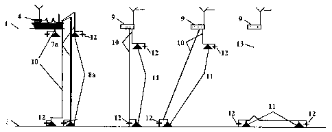
Figure 5 shows a schematic view in which the reference nu-
meral 1 indicates a water surface of a water layer 2 above a
seabed 3 and with a vessel 4 floating on the water surface 1.
A vertical transmitter cable 7a is terminated by water-filled
transmitter electrodes 8.
A horizontal receiver cable 10a connects receiver electrodes
11 to a registration unit 9 comprising a surface buoy 9a and
a connecting cable 10c.
The positioning and orientation of the electrodes 8, 11 are
controlled by tilt sensors / transponders 12.
The vessel 4 is provided with a radio station 6 and an aerial
5. The registration unit 9 is provided with,an aerial 13 for
signal communication with the radio station 6 of the vessel
4.
Figure 6 shows schematically a view of an alternative con-
figuration, the reference numeral 7b indicating a horizontal
transmitter cable and 10b indicating vertical receiver ca-
bles.
The horizontal transmitter cable 7b is connected to the ves-
sel 4 via a connecting cable 7c.
In both configurations the measuring electrodes are to remain
in the same vertical plane as the terminations of the trans-
mitter cable.
In a main mode of operation of the TEMP-OEL, the vessel 4,
transmitter 7a, 7b and receivers lia, lib are fixed in their
positions for a period sufficient for achieving the pre-
scribed quality of the acquired data. The radio station 6 and
aerials 5, 13 are used for communication between the trans-
CA 02669307 2009-05-12
WO 2008/066389 PCT/N02007/000416
12
mitter 7a, 7b and the receivers 10a, 10b, especially to con-
trol the data acquisition while the survey is going on. This
enables repetition of measurements if, in a measurement, a
satisfactory signal quality has not been achieved.
4)
The tilt sensors/transponders 12 are used for accurate deter-
mination of the positions of the transmitter and receiver
electrodes 8, 11.
The data acquired is processed, analysed and transformed into
diagram plots for voltage/apparent resistivity versus time
and depth and/or 1D inversion. Whenever necessary, transfor-
mation into 2,5D and 3D inversions and interpretation of
these can be carried out.
CA 02669307 2009-05-12
WO 2008/066389 PCT/N02007/000416
13
Litterature list
US patents
Publication No. Published Applicant
4,644,892 10/1985 Kaufman et al.
4,617,518 10/1986 Srnka
5,563,513 10/1996 Tasci
6,320,386 B1 11/2001 Balashov et al.
0052685 Al 03/2003 Ellingsrud et al.
0048105 Al 03/2003 Ellingsrud et al.
6,628,119 Bl 10/2003 Eidesmo et al.
G01V003/12 08/2004 Ellingsrud et al.
G01V001/00 01/2005 Ellingsrud et al.
G01V003/08 10/2005 Wright et al.
324334000 02/2006 Constable
Other patent publications
Publication No. Published Applicant
WO 01/57555 Al 09/2001 Ellingsrud et al.
WO 02/14906 Al 02/2002 Ellingsrud et al.
WO 03/025803 Al 03/2003 Srnka et al.
WO 03/034096 Al 04/2003 Sinha et al.
WO 03/048812 Al 06/2003 MacGregor et al.
NO 20055168 11/2005 Barsukov et al.
CA 02669307 2009-05-12
WO 2008/066389 PCT/N02007/000416
14
Other publications
Amundsen H.E.F., Fanavoll S., Loseth L., Simonsen I., Skogen
E. 2003: Svanen Sea Bed Logging (SBL) Survey Report.
Amundsen H.E.F., Johansen S. R6sten T. 2004: A Sea Bed Log-
ging (SBL) calibration survey over the Troll Gas Field.
66th EAGE Conference & Exhibition, Paris, Frankrike, 6.-
10. June 2004.
Chave A.D., Cox C.S. 1982: Controlled Electromagnetic Sources
for Measuring Electrical conductivity Beneath the Oceans
1. Forward Problem and Model Study. Journal of geophysi-
cal Research, 87, B7, p. 5327-5338.
Chave A. D., Constable S.C., Edwards R.N. 1991: Electrical
Exploration Methods for the Seafloor. Chapter 12. Ed. by
Nabighian, Applied Geophysics, v. 2, Soc. Explor. Geo-
physics, Tusla, Okla., p. 931-966.
Cheesman S.J., Edwards R.N., Chave A.D. 1987: On the theory
of sea floor conductivity mapping using transient elec-
tromagnetic systems. Geophysics, v. 52, N2, p. 204-217.
Chew W.C., Weedon W.H. 1994: A 3D perfectly matched medium
from modified Maxwell's equations with stretched coordi-
nates. IEEE Microwave and Guided Wave letters, 4, p. 268-
270.
Cox C.S., Constable S.C., Chave A.D., Webb S.C. 1986: Con-
trolled source electromagnetic sounding of the oceanic
lithosphere. Nature, 320, p. 52-54.
Constable S.C., Orange A.S., Hoversten G.M., Morrison H.F.
1998: Marine magnetotellurics for petroleum exploration.
Part 1: A sea floor equipment system. Geophysics, v. 63,
N3, p. 816-825.
CA 02669307 2009-05-12
WO 2008/066389 PCT/N02007/000416
Constable, 2006: Marine electromagnetic methods - A new tool
for offshore exploration. The Leading Edge, v. 25, p.
438-444.
Constable & C. J. Weiss, 2006: Mapping thin reservoirs and
s hydrocarbons with marine EM methods: Insights from 1D
modeling. Geophysics, v. 71, p. G43-G51.
Coggon J.H., Morrison. H.F. 1970: Electromagnetic investi-
gation of the sea floor: Geophysics, v. 35, p. 476-489.
Edwards R.N., Law, L.K., Delaurier, J.M. 1981: On measuring
10 the electrical conductivity of the oceanic crust by a
modified magnetometric resistivity method: J. Geophys.
Res., v. 68, p. 11609-11615.
Edwards R.N., Nobes D.C., Gomez-Trevino E. 1984: Offshore
electrical exploration of sedimentary basins: the effects
1s of anisotropy in horizontally isotropic, layered media.
Geophysics, v. 49, N 5, p. 566-576.
Edwards R.N., Law L.K., Wolfgram P.A., Nobes D.C., Bone M.N.,
Trigg D.F., DeLaurier J.M. 1985: First results of the
MOSES experiment: Sea sediment conductivity and thickness
determination. Bute Inlet, British Columbia, by magne-
tometric off-shore electrical sounding. Geophysics, v.
450, N1, p. 153-160.
Edwards R.N. and Chave A.D. 1986: On the theory of a tran-
sient electric dipole-dipole method for mapping the con-
ductivity of the sea floor: Geophysics, v. 51, p. 984-
987.
Edwards R. 1997: On the resource evaluation of marine gas hy-
drate deposits using sea-floor transient dipole-dipole
method. Geophysics, v. 62, Ni, p. 63-74.
CA 02669307 2009-05-12
WO 2008/066389 PCT/N02007/000416
16
Edwards R.N. 1998: Two-dimensional modeling of a towed in-
line electric dipole-dipole sea-floor electromagnetic
system: The optimum time delay or frequency for target
resolution. Geophysics, v. 53, N6, p. 846-853.
Eidesmo T., Ellingsrud S., MacGregor L.M., Constable S., Sin-
ha M.C., Johansen S.E., Kong N. and Westerdahl, H. 2002:
Sea Bed Logging (SBL), a new method for remote and direct
identification of hydrocarbon filled layers in deepwater
areas. First Break, 20. mars, p. 144-152.
Ellingsrud S., Sinha M.C., Constable S., MacGregor L.M., Ei-
desmo T. and Johansen S.E. 2002: Remote sensing of hydro-
carbon layers by Sea Bed Logging (SBL): results from a
cruise offshore Angola. The Leading Edge, 21, p. 972-982.
Farelly B., Ringstad C., Johnstad C.E., Ellingsrud S. 2004:
Remote Characterization of hydrocarbon filled reservoirs
at the Troll field by Sea Bed Logging. EAGE Fall Research
Workshop Rhodos, Hellas, 19.-23. september 2004.
Greer A.A., MacGregor L.M. and Weaver R. 2004: Remote mapping
of hydrocarbon extent using marine Active Source EM
sounding. 66th EAGE Conference & Exhibition, Paris, Fran-
krike, 6.-10. juni 2004.
Haber E., Ascher U. and Oldenburg D.W. 2002: Inversion of 3D
time domain electromagnetic data using an all-at-once ap-
proach: submitted for presentation at the 72nd Ann. In-
ternat. Mtg: Soc. of Expl. Geophys.
Howards R.N., Law L.K., Delaurier J.M. 1981: On measuring the
electrical conductivity of the oceanic crust by a modi-
fied magnetometric resistivity method: J. Geophys. Res.,
86, p. 11609-11615.
CA 02669307 2009-05-12
WO 2008/066389 PCT/N02007/000416
17
Johansen S.E., Amundsen H.E.F., Rosten T., Ellinsgrud S., Ei-
desmo T., Bhuyian A.H. 2005: Subsurface hydrocarbon de-
tected by electromagnetic sounding. First Break, v. 23,
p. 31-36.
Kaufman A.A., and Keller G.V., 1983: Frequency and transient
soundings: Amsterdam, Elsevier Science Publ. Co., p. 411-
454.
Kong F.N., Westerdahl H, Ellingsrud, S., Eidesmo T. and Jo-
hansen S. 2002. 'Seabed logging': A possible direct hy-
drocarbon indicator for deep sea prospects using EM en-
ergy: Oil and Gas Journal, 13. mai 2002, p. 30-38.
MacGregor L., Sinha M. 2000: Use of marine controlled-source
electromagnetic sounding for sub-basalt exploration. Geo-
physical prospecting, v. 48, p. 1091-1106.
is MacGregor L., Sinha M., Constable S. 2001: Electrical resis-
tivity of the Valu Fa Ridge, Lau Basin, from marine con-
trolled-source electromagnetic sounding. Geoph. J. In-
tern. v. 146, p. 217-236. '
MacGregor L., Tompkins M., Weaver R., Barker N. 2004: Marine
active source EM sounding for hydrocarbon detection. 66th
EAGE Conference & Exhibition, Paris, Frankrike, 6.-10.
juni 2004.
Marine MT in China with Phoenix equipment.,2004. Publisert av
Phoenix Geophysics Ltd., utgave 34, desember 2004, p. 1-
2.
Singer B.Sh., Fainberg E.B. 1985: Electromagnetic induction
in non-uniform thin layers, IZMIRAN, p. 234.
CA 02669307 2009-05-12
WO 2008/066389 PCT/N02007/000416
18
Singer B. Sh. 1995: Method for solution of Maxwell's equa-
tions in non-uniform media. Geophysical Journ. Int. 120,
p. 590-598.
Singer, B. Sh., Mezzatesta, A. & Wang, T., 2003: Integral eq-
uation approach based on contraction operators and Krylov
space optimization, in Macnae, J. and Liu, G. (eds),
"Three-Dimensional Electromagnetics III", ASEG, 26, p. 1-
14.
Singer, B. Sh. & Fainberg, E. B., 2005: Fast inversion of
synchronous soundings with natural and controllable
sources of the electromagnetic field. Izvestiyu, Physics
of the Solid Earth, 41, 580-584. (Translated from Fizika
Zemli, 2005, N 7, p. 75-80).
Sinha, M.C., Patel P.D., Unsworth M.J., Owen T. R.E., MacCor-
mack M.R.G., 1990: An Active Source Electromagnetic
Sounding System for Marine Use, Marine Geophys. Res., 12,
p. 59-68.
Tompkins M., Weaver R., MacGregor L. 2004: Sensitivity to hy-
drocarbon targets using marine active source EM sounding:
diffusive EM mapping methods. 66th EAGE Conference & Ex-
hibition, Paris, Frankrike, 6.-10. juni 2004.
Wright D.A., Ziolkowski A., Hobbs B.A. 2001: Hydrocarbon de-
tection with a multi-channel transient electromagnetic
survey, 70th Ann. Internat. Mtg,, Soc. of Expl. Geophys.
Wicklund T.A., Fanavoll S. 2004: Norwegian Sea: SBL case
study. 66th EAGE Conference & Exhibition, Paris, Frank-
rike, 6.-10. juni 2004.
Wolfgram P.A., Edwards R.N., Law L.K., Bone M.N. 1986: Poly-
metallic sulfide exploration on the deep sea floor: The
CA 02669307 2009-05-12
WO 2008/066389 PCT/N02007/000416
19
feasibility of the MINI-MOSES experiment. Geophysics, v.
51, N9, p. 1808-1818.
Yuan J., Edward R.N. 2001: Towed seafloor electromagnetics
and assessment of gas hydrate deposits. Geophys. Res.
Lett. v. 27, N6, p. 2397-2400.
Yuan J., Edward R.N. 2004: The assessment of marine gas hy-
drates through electrical remote sounding: Hydrate with-
out BSR? Geophys. Res. Lett. V. 27, N16, p. 2397-2400.
Ziolkovsky A., Hobbs B., Wright D. 2002: First direct hydro-
io carbon detection and reservoir monitoring using transient
electromagnetics. First Break, v. 20, No4, p. 224-225.
P25167PCOODEvrio -18. 01.200R