Note: Descriptions are shown in the official language in which they were submitted.
CA 02671344 2012-06-01
WO 2008/070494 PCT/US2007/085729
SYSTEM FOR AUTOMATICALLY DETERMINING CELL TRANSMITTER
PARAMETERS TO FACILITATE THE LOCATION OF WIRELESS DEVICES
CROSS REFERENCE
[0001] The present application claims priority to U.S. Application No.
11/607,420,
filed December 1, 2006, entitled "System for Automatically Determining Cell
Transmitter
Parameters to Facilitate the Location of Wireless Devices," which is hereby
incorporated by
reference in its entirety.
TECHNICAL FIELD
[0002] The present invention relates generally to the field of wireless
communications,
and more specifically to the location of devices within the coverage area of a
wireless
communications network.
BACKGROUND
[0003] Several techniques for locating wireless devices involve the Mobile
Station
(MS) making measurements of the signals transmitted by the base stations of a
wireless
communication network. (The term MS or Mobile Station, as used herein, refers
to any type of
wireless phone or other mobile device having a radio communications
capability.) These
techniques are known by the acronyms EOTD, AFLT, OTD and ECID.
= Enhanced Observed Time Difference (E0TD) is a location technique defined
in the
ETSI 3GPP Technical Specification 43.059 in which a GSM MS makes relative time
difference measurements of the beacon signals transmitted by geographically
distributed base stations, where these measurements are used to compute a
position.
- -
CA 02671344 2009-06-01
WO 2008/070494 PCT/US2007/085729
= Advanced Forward Link Trilateration (AFLT) is a technique defined in the
TIA IS-95
and CDMA 2000 standards in which a CDMA MS makes relative time difference
measurements of the pilot signals transmitted by geographically distributed
CDMA
base stations, where these measurements are used to compute a location.
= Observed Time Difference (OTD) is a location technique defined in the
ETSI 3GPP
Technical Specification 23.271 in which the User Equipment (UE), which is
essentially a mobile station in a UMTS network, makes relative time difference
measurements of the signals transmitted by geographically distributed Node Bs
(base
stations in a UMTS system), where these measurements are used to compute a
location.
= Enhanced Cell Identification (EC1D) is a technique used to locate GSM MSs
in which
the MSs perform received power level measurements of the signals transmitted
by
geographically distributed GSM base stations, where these measurements are
used to
compute locations.
[0004] All of these location techniques involve a MS measuring signals whose
characteristics vary as a function of the distance between the MS and the Base
Stations
transmitting the signals. In addition, all of these location techniques
require knowledge of key
cell site information. Such key cell site information may include cell
identification information
and transmit antenna location. In addition, some of these location techniques
require additional
information about the transmitters, such as transmitter signal timing, signal
transmit power, and
signal propagation or signal loss in the environment. This information can be
difficult to obtain
from wireless network operators because it is dynamic and distributed across
multiple data bases.
This information may be difficult to obtain and maintain across multiple
wireless network
operators, as some operators may not be willing to cooperate and provide this
information. The
accuracy of each of the location techniques described above will be improved
if a larger number
of the base station signals are used in the location solution, which is
possible when the transmit
signals across multiple wireless networks are available. The accuracy of each
of these techniques
is dependent upon the number and quality of the signals available for
measurement, and so the
ability for a location solution to utilize these signals across multiple
wireless networks will
provide better performance than could be achieved if the measurements were
limited to the
signals of a single wireless network.
[0005] One goal of the present invention is to provide an automatic way to
detect the
existence of one or more useful wireless transmitters, determine the cell
identification
information so that each transmitter can be referred to later, determine the
transmitter antenna
- 2 -
CA 02671344 2009-06-01
WO 2008/070494 PCT/US2007/085729
locations, determine the transmitter timing, determine the transmitter power
level, and determine
the signal power loss as a function of location, so that any such wireless
transmitter can be used
to locate mobile stations.
SUMMARY
[0006] The following summary is intended to explain several aspects of the
illustrative
embodiments described in greater detail below. This summary is not intended to
cover all
inventive aspects of the disclosed subject matter, nor is it intended to limit
the scope of
protection of the claims set forth below.
[0007] In one illustrative embodiment, the present invention provides a system
for
locating a mobile wireless device. The system includes a location processing
node, at least one
wireless device, and a server. In an exemplary embodiment, the wireless device
is configured to
communicate with the location processing node via a communications link, and
to make
scanning measurements of signals from one or more geographically distributed
transmitters.
Moreover, the at least one wireless device is further configured to assist the
location processing
node in determining key transmitter information by receiving and measuring
characteristics of
the signals and providing information about these characteristics via the
communications link to
the location processing node. The server is configured to communicate with a
wireless device to
be located, and to cause the wireless device to make signal measurements of
signals from one or
more transmitters and to provide measurement information to the location
processing node. The
characteristics measured by the at least one wireless device are useful to
determine the key
transmitter information.
[0008] In an illustrative embodiments, the at least one wireless device is
further
configured to communicate the key transmitter information to the location
processing node,
wherein the information may be used by the location processing node to compute
the location of
one or more wireless devices. In addition, the system is configured to operate
with the one or
more transmitters, and at least one transmitter is part of a first wireless
communications network
and at least one transmitter is part of a second wireless communications
network. The server may
also be configured to communicate via a user plane data channel with the at
least one wireless
device, and the wireless device may be configured to provide measurement
information via the
data channel to the location processing node.
[0009] The key transmitter information preferably includes cell identification
information, which may include at least one member of the group consisting of
Cell ID,
frequency channel, base station identity code, Cell Global Identity, and Base
Station ID. The key
transmitter information may also include cell transmitter location
information, which may
- 3 -
CA 02671344 2013-08-27
include latitude and longitude, and possibly altitude. In addition, the key
transmitter information
may include cell transmitter signal timing information, and the signal
measurements may include
relative signal timing and/or absolute signal timing.
[0010] The present invention also provides, and may be embodied in, methods,
wireless devices,
and computer readable media comprising software for carrying out the functions
and activities
described herein.
[0010a1 Also provided herein is a system for automatically providing key
transmitter information
for use in locating a mobile wireless device operating in a wireless
communications network,
wherein said wireless communications network includes a network of a plurality
of
geographically distributed base stations, each base station including a cell
transmitter configured
to transmit broadcast signals in one or more prescribed wireless frequency
bands, wherein the
broadcast signals from different ones of the cell transmitters are not
synchronized with one
another, the system comprising:
a location processing node; and,
a plurality of wireless scanning devices, wherein each said wireless scanning
device is
configured to communicate with said location processing node via a
communications link; and,
to assist the location processing node in determining said key transmitter
information, wherein
said key transmitter information includes cell identification information,
cell transmitter location
information, and cell transmitter signal timing information, each said
wireless scanning device
configured for automatically: (i) scanning available wireless frequency bands;
(ii) measuring
characteristics of broadcast signals from one or more said cell transmitters;
and, (iii) providing
scanning measurement information based on said measured characteristics via
the
communications link to said location processing node;
wherein the system periodically checks to identify any new cell identification
information
from the broadcast signals, and the location processing node is configured to
determine said key
transmitter information using the scanning measurement information
automatically provided by
the wireless scanning devices including determining new cell transmitter
location information for
any identified new cell identification infounation.
10010b] Further provided herein is a method for locating a mobile wireless
device, comprising:
instructing at least one wireless scanning device to communicate with a
location
-4-
CA 02671344 2013-08-27
processing node via a communications link, and to make scanning measurements
of one or more
characteristics of broadcast signals from one or more unsynchronized,
geographically distributed
transmitters, and further instructing said at least one wireless scanning
device to automatically
provide scanning measurement information about said characteristics via the
communications
link to said location processing node;
instructing a mobile wireless device to be located to make signal measurements
of
broadcast signals from one or more said transmitters and to provide mobile
device measurement
information to said location processing node;
determining key transmitter information regarding the transmitters using said
scanning
information automatically provided by the wireless scanning device(s), said
key transmitter
information including transmitter identification information, transmitter
location information,
and transmitter signal timing information; and,
at the location processing node, using said key transmitter information and
said mobile
device measurement information to determine the geographic location of said
mobile wireless
device to be located;
wherein the method is performed such that, once a set of transmitter location
information
is established, that set of transmitter location information is assumed to be
correct when used to
determine the geographical location of the mobile wireless device to be
located.
[0010c] Additionally provided herein is a method for locating a mobile
wireless device in a
communications network comprising a plurality of geographically distributed
transmitters and a
location processing node, said method comprising:
providing a first wireless device to assist the location processing node to
determine key
transmitter information for each said transmitter wherein said transmitters
include at least one
new transmitter for which key transmitter information has not been determined
by the location
processing node, the first wireless device being configured to automatically:
(i) communicate
with the location processing node via a communications link; (ii) make
scanning measurements
of characteristics of signals from each of said transmitters; and, (iii) for
each said transmitter,
provide scanning measurement information about said characteristics via the
communications
link to said location processing node, wherein the scanning measurement
information is
periodically checked for new transmitter identification information for the
new transmitter and,
-4a-
CA 02671344 2013-08-27
when new transmitter identification information is identified, the location
processing node
determines key transmitter information for the new transmitter using said
scanning measurement
information, said key transmitter information for each said transmitter
including transmitter
identification information, transmitter location information and transmitter
signal timing
information;
providing a second wireless device configured to make signal measurements of
signals
from one or more said transmitters and to provide wireless device measurement
information to
said location processing node; and
at the location processing node, using said key transmitter information and
said wireless
device measurement information to determine the geographic location of said
second wireless
device.
[0011] Other aspects and embodiments of the present invention are described
below.
BRIEF DESCRIPTION OF THE DRAWINGS
[0012] The foregoing summary as well as the following detailed description are
better
understood when read in conjunction with the appended drawings. For the
purpose of illustrating
the invention, there is shown in the drawings exemplary constructions of the
invention; however,
the invention is not limited to the specific methods and instrumentalities
disclosed. In the
drawings:
[0013] Figure 1 is a block diagram depicting an environment, including two
wireless
communications networks, in which the present invention may be deployed.
[0014] Figure IA schematically illustrates how a mobile wireless device (which
could be an LDP
device or any other kind of MS), may be configured to communicate via a data
channel with a
server (which could be a Location Enabling Server or other type of server).
The server may be
configured to communicate via the data channel with wireless devices to be
located, and to cause
the devices to make measurements of signals from one or more transmitters and
to provide
measurement information to a location processing node (which could be the same
node as the
LES, or a different node).
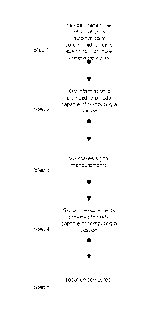
[0015] Figure 2 is a flowchart of a process in accordance with an illustrative
embodiment of the
present invention.
-4b-
CA 02671344 2013-08-27
= =
[0016] Figure 3 is a block diagram referenced below in explaining how the
location of a mobile
station (MS) may be computed using the measurements and base station
parameters acquired in
accordance with the present invention.
DETAILED DESCRIPTION OF ILLUSTRATIVE EMBODIMENTS
[0017] We will now describe illustrative or presently preferred embodiments of
the present
invention. First, we provide an overview and then a more detailed description.
Overview
[0018] The present invention provides a system for locating devices within the
coverage area of
a wireless network. The invention may be embodied in a system that employs
-4c-
CA 02671344 2009-06-01
WO 2008/070494 PCT/US2007/085729
much of the existing infrastructure in a wireless network. For example, the
system may utilize
the wireless network to facilitate communication between the MSs and a
location server. The
system may employ a user-plane, or Secure User-plane (SUPL), connection
between the MS and
the location server. An example of such a user plane is defined by an Open
Mobile Alliance
technical standard (see www.openmobilealliance.org).
[0019] Co-pending Patent Application No. 11/533,310, filed September 19, 2006,
entitled "USER PLANE UPLINK TIME DIFFERENCE OF ARRIVAL (U-TDOA)," describes a
user plane approach to network-based wireless location. Typical U-TDOA
solutions are often
based on the control plane architecture, which can require extensive
modifications of the mobile
network infrastructure in line with the ANSI/3GPP location services standards
(for example,
ANSI/ETSI J-STD-036 and ANSI ESTI GSM 03.17). The control plane approach
involves the
use of information conveyed in the control or voice channels (also known
respectively as the
access channel and traffic channels, among other names) to locate the mobile
device. In contrast,
in a user plane architecture, the location server can communicate directly
with the mobile device
via a data or IP (Internet Protocol) link carried by the wireless operator's
radio network but not
part of the control/voice (or access/traffic) channel structures, thus
requiring no modifications to
the core or radio network. The '310 application describes a system that may be
used to instruct
the wireless location system (WLS) how to locate a mobile device (such as an
LDP Device,
where LDP stands for location device platform). In the control plane approach,
the WLS waits
for information from the wireless communications network before calculating a
position,
whether via U-TDOA, Cell-ID, Cell-ID+Timing Advance, or Cell-ID with Power
Difference of
Arrival. In the user plane approach, the mobile device provides to an LES
(also called the
Location Enabling Server, or LES) sufficient information over the data channel
to perform the
location calculation. The information provided to the LES is known to the
mobile device (i.e.,
LDP Device) and this knowledge is leveraged to facilitate the location
calculation. In addition,
the mobile information can also be used for tasking, for example, to task the
U-TDOA/AoA
WLS since the information sent over the data connection can include serving
cell, neighboring
cells, frequency, and hopping pattern information. In the prior control plane
approach, this
information is obtained from the network via the ES, Lb or Iupc interface (for
example) and not
from the mobile over a data channel.
[0020] Figure 1 shows an illustrative environment in which the present
invention may
be used. In this figure, a first wireless network includes a central office 41
and Base Transceiver
Stations (BTSs) 10, 11, 12. Mobile devices, or MSs 31, 32, and 33, can
communicate voice and
data using this first wireless network. The MSs (31, 32, 33) and the location
server 51 are
- 5 -
CA 02671344 2009-06-01
WO 2008/070494 PCT/US2007/085729
connected by an IP connection provided by the first wireless network. In a
user-plane solution,
an application runs on the MS, which would perform the signal measurements
when commanded
by the server 51 through the IP connection and report the results of these
measurements through
the IP connection. The advantage of a user-plane implementation is that it
does not require a
wireless network operator to place additional features and infrastructure into
the wireless
network to support location related messaging between the MS and the location
server 51. The
MSs make measurements of the signals transmitted by BTSs 10, 11, 12 of the
first wireless
network, as well as the signals transmitted by the BTSs 21, 22, 23 of a second
wireless network,
which includes a second central office 42. These measurements, along with the
derived cell site
information, are used to determine the mobile device positions. Figure 1 also
depicts wireless
links 61, 62 and 63.
[0021] Figure 1A illustrates how a server and location processing node, which
may be
part of the server or a different node, may be configured or programmed to
communicate with
one or more wireless devices over a user plane data link 300. To perform an
enhanced network-
based location, a MS 31 may be configured to receive broadcast acquisition
data, register on the
wireless communications system (if required) and then request data service
from the wireless
network to establish a data link or channel 300 as shown. In contrast to the
control channels and
signaling of the wireless communications system (the control plane), the data
channel 300 (the
user plane) supports a modulation to support data transmissions (data
signaling is not re-encoded
and compressed by the wireless communications system as with voice signaling,
but rather
passes though the wireless system as shown in Figure 1A). The payload contents
of the data
channel 300 do not require examination or modification by the functional
elements of the
wireless communications system. The data channel payload does not inform,
control, or modify
the operations of the elements of the wireless communications system as does
control channel
data. The data channel 300 may be carried as payload in an assigned data
channel either as raw
binary data or in a voice channel as a series of voice frequency tones. The
data connection may
be routed by the data network (reference numeral 300 in Figure 1A) to a server
51 and/or
location processing node 52. Upon connection with the server or location
processing node, the
MS 31 then transmits its data. Similarly, the data channel may be used to
transmit commands
from a server to the MS.
[0022] Exemplary aspects of the inventive system include the following:
1. The key information for each base station transmitter is determined across
one or
more wireless networks. This key information may include:
= Cell Identification information;
- 6 -
CA 02671344 2009-06-01
WO 2008/070494 PCT/US2007/085729
= Transmitter location, including latitude, longitude and altitude;
= Signal timing;
= Signal transmit power; and
= Signal propagation.
2. This key information is provided to a node capable of computing a location.
This
node could be the MS, the location server, or some other node.
3. The MS to be located makes measurements of transmitted signals. Signal
measurements may include timing, power level measurements, or signal to noise
ratio
measurements.
4. Signal measurements performed by the MS are provided to a node capable of
computing a location.
[0023] The step of providing information for each base station may include the
following steps:
1. Fixed or wireless devices scan for wireless base station signals;
2. Devices determine cell or base station identification information;
3. Devices make measurements of the received base station signals. Such
measurements may include signal timing/phase and power level.
4. The key transmitter parameters are determined based on these signal
measurements.
[0024] This concept is distinct from several location concepts defined in the
prior art,
which generally require that the transmitter location and timing, and transmit
power are known.
See, e.g., U.S. Patent Nos. 5,293,645 (Sood); 6,529,165 (Duffet-Smith);
5,646,632 (Khan);
5,045, 861 (Duffet-Smith); and 6,094,168 (Duffet-Smith). For example, U.S.
Patent No.
6,529,165 identifies a method to determine the position of a MS, as well as
the base station
signal timing, through a complex matrix solution. This solution requires the
cell IDs and cell
positions to be known a priori. The present invention provides for automatic
determination of
relevant cell site information, which may include identification for the cell
sites, positions for the
cell transmit antenna, transmit power and signal propagation.
Detailed Description of System for Automatically Determining Cell Transmitter
Parameters
[0025] As discussed above, Figure 1 is a high level diagram of one presently
preferred
embodiment. Elements 10, 11, and 12 are BTSs, which are part of a first
wireless network.
- 7 -
CA 02671344 2009-06-01
WO 2008/070494 PCT/US2007/085729
Elements 21, 22, and 23 are BTSs that are part of a second wireless network.
Elements 31, 32,
and 33 are devices existing within the first wireless network, and these
devices are capable of
making signal measurements, including time difference and/or power level
measurements. The
devices could be fixed devices with known position, or mobile devices with
known or unknown
positions. Elements 41 and 42 are the central office equipment of the first
and second wireless
networks, and element 51 is a location server, which is connected to the MSs
31, 32, and 33 via
wireless links 61, 62, and 63, through the first wireless network.
[0026] Location server 51 tasks MSs 31, 32, and 33 via commands through the
wireless
network to scan all available wireless bands for base station broadcast
signals. In North America,
this could include the cellular (800 MHz) band and PCS (1900 MHz) band. In
Europe, this could
include the GSM (900 MHz) band and the PCN (1800 MHz) band, or the UMTS (2100
MHz)
band. In other regions, these bands may be different, and over time the set of
bands may change
as licenses for wireless service evolve. During this scanning process, the MS
will store
information for each of the base stations it can detect. The MS may be
commanded to scan and
report cell information for cells outside of its home network, as these cells
are just as useful as
the cells of the home network in supporting location related measurements.
This cell information
may include: cell identification information, broadcast channel number or
frequency, received
signal power, and relative time difference of received signals. This
information may then be
provided to the location server 51. If the MS has any other relevant position
information, such as
a position determined from a built-in UPS receiver, or if the MS's position is
fixed and is known,
or if the timing of the device can be mapped to timing derived in the device
by UPS, this
information can be provided to the server as well. This information from many
MSs can be
collected by the location server 51 and used to determine information that can
be used to locate
these MSs, and other MSs in the area, in the future.
[0027] Figure 2 is a flowchart of a high level process embodying this location
technique. The process may be described as follows:
[0028] Step 1: The key information for the base station transmitter is
determined across
one or more wireless networks. This key information includes:
= Cell Identification information
= Transmitter location, including latitude, longitude and altitude
= Signal timing
= Signal transmit power
= Signal propagation
- 8 -
CA 02671344 2009-06-01
WO 2008/070494 PCT/US2007/085729
[0029] Step 2: This key information is provided to a node capable of computing
a
location. This node could be the MS, the location server, or some other node.
[0030] Step 3: MS makes measurements of transmitted signals. Signal
measurements
may include timing, power level measurements, or signal to noise ratio
measurements.
[0031] Step 4: Signal measurements made by the MS are provided to node capable
of
computing a location.
[0032] Step 5: MS location is computed.
[0033] Step 1, providing key site information, preferably includes the
following: Fixed
or wireless devices scan for wireless base station signals. The devices
determine cell or base
station identification information, and make measurements of the received base
station signals,
including signal timing/phase and power level. The signal measurements made by
these devices
are provided to a Location Node, along with the determined cell or base
station identification
information are provided to a node, where this information is used to
determine the cell site
transmitter location, cell transmitter signal timing, signal transmit power,
and signal transmit
power loss as a function of location.
GSM Scanning
[0034] For a GSM system as defined in the ETSI 3GPP specifications, the
scanning
processing could include many of the methods already used by GSM MSs to
acquire downlink
beacon signals, and cells within a GSM network. For example: The MS will scan
each 200 kHz
channel in each band it supports. At each channel, the MS tries to detect the
Frequency
Correction Channel (FCH) to identify downlink beacon signals and to make
frequency
adjustment to aid further acquisition of the downlink signals. The FCH
contains a single tone
signal, which appears on the downlink beacon channel at a regular interval.
The channel could be
detected, e.g., through a matched filter or a correlation process. The
Absolute Radio Frequency
Channel Number (ARFCN) for each detected FCH is useful information for future
measurements. If a FCH is found, or possibly even if it is not found, the MS
will attempt to
detect the Synchronization Channel (SCH), which contains a frame with a known
data pattern
that repeats on the beacon channel at a regular interval. This signal could be
detected with a
matched filter or correlation techniques. The SCH contains a SCH information
message that
contains the Base Station Identify Code (BSIC) and the parameters Ti, T2, and
T3, which
describe the GSM frame number. At this time, a timing measurement could be
made, relative to
an internal MS clock or to another measured signal. The signal power could be
measured as well.
- 9 -
CA 02671344 2009-06-01
WO 2008/070494 PCT/US2007/085729
This channel can be used by the MS to determine the frame timing of the beacon
signal to allow
further analysis of the downlink beacon signal.
[0035] Next, the MS could demodulate the Broadcast Control Channel (BCCH) to
gather additional information about the cell. The BCCH contains System
information messages
that could be used for cell identification, as well as aid further scanning.
For example, the
System information Type 2, or Type 2bis message, contains the BCCH Frequency
List, which
contains the ARFCNs of the beacon channels of the neighbor cells. This could
be used to guide
the MS to the next set of channels to scan. System information Type 3 contains
the Cell
Identification, which can be used to identify this cell, to correlate this
measurement with other
measurements made by the same or different MSs, made simultaneously or at
different times.
System information Type 6 also contains the Cell Identification, which can be
used to identify
this cell, to correlate this measurement with other measurements made by the
same or different
MSs, made simultaneously or at different times.
[0036] Therefore, by scanning the channels, the MS is able to determine the
ARFCN,
the BSIC, the Cell ID, list of neighbor cell frequencies, cell timing, and
received signal power.
IS-95/CDMA-2000 Scanning
[0037] A similar scanning process could be used by an IS-95 or CDMA-2000
system.
For example: First the MS scans the forward link Pilot Channel. Each cell
transmits the Pilot
Channel, but at different time offsets relative to an absolute time. The Pilot
Channel is detected
by the MS through correlation or matched filter techniques. At this time, a
timing measurement
could be made, relative to an internal MS clock or relative to another
measured signal. The signal
power could be measured as well.
[0038] Once the Pilot Channel is acquired, the MS can decode the Synch
Channel. The
Synch Channel provides the current time of day, as well as the Long Code State
and the offset
applied to the Pilot Channel.
[0039] Once the MS has decoded the Synch Channel, it can decode the Paging
Channel. The Paging Channel contains the System Parameters Message, which
contains the Base
Station ID. The Paging Channel also contains the Neighbor List message, which
defines the set
of channels and Pilot Channel offsets the MS can use to search for neighbor
cells.
UMTS Scanning
[0040] A similar scanning process can be used in a UMTS system, as is used in
an IS-
95/CDMA 2000 system. For example: First the UE acquires the Primary
Synchronization
Channel. The Primary synchronization channel is common to all cells and
transmits the Primary
- 10 -
CA 02671344 2009-06-01
WO 2008/070494 PCT/US2007/085729
Synchronization Code (PSC). The channel can be acquired through matched filter
or correlation
techniques.
[0041] Once the UE has acquired the PSC, it is able to able to acquire the
Secondary
Synchronization Channel (S-SCH). The S-SCH allows the UE to determine frame
synchronization, and to identify the scrambling code used for the BCCH for
that cell. At this
time, a timing measurement could be made, relative to an internal MS clock or
to another
measured signal. The signal power could be measured as well.
[0042] Once the scrambling code is determined for the cell, the UE is able to
de-spread
the Broadcast Physical Channel, and obtain system information form the BCCH.
The BCCH
contains cell identification information as well as neighbor cell information.
[0043] The scanning process may repeat, or particular mobiles may be asked to
re-scan
all channels, or particular channels to improve the reliability and accuracy
of the measurements.
[0044] The scanning technique in general is common to all air interfaces, and
is not
limited to the air interfaces specifically discussed herein, but apply to
WiFi, WiMAX, WiBro,
and other air interfaces, whether currently used or defined in the future. The
scanning may be
performed by mobile devices (MSs) where the location of the device is unknown,
or by fixed
devices, such as Mobile Stations or Location Measurement Units (LMUs) deployed
in known
locations.
[0045] The measurements and information determined from the MS scanning are
provided to a node, which uses this to determine the remaining key cell site
information,
including cell transmitter locations, cell transmitter timing, cell transmit
power, and signal
propagation.
Determination of Key Cell Site Information
[0046] For a location system based on downlink timing measurements, the
additional
key information includes transmitter position and transmitter timing. This key
information can be
derived as explained below.
[0047] Figure 3 shows a simple two-transmitter, one-receiver scenario, with
cell
M
transmitters Sc and Sb along with a single mobile station a .
[0048] In this scenari.o, OTDmeas
a, ,c represents the measured time difference of arrival
Toff
b is the time offset of cell site transmitter 5b, relative to some absolute
time.
Toff
c is the time offset of cell site transmitter Sc , relative to some absolute
time.
- 11 -
CA 02671344 2009-06-01
WO 2008/070494 PCT/US2007/085729
(Latma, Lon ma) are potential coordinates for a mobile station measurement Ma
.
(Latsb Lon Sb) are potential coordinates of cell site transmitter S b .
(Lat , Lon S
Sc Sc c) are potential
coordinates of cell site transmitter .
C is the velocity of propagation of an electromagnetic wave in air (or a
vacuum).
-7 a ,b ,c is the expected standard deviation of the OTD measurement.
[0049] An error is computed for each OTD measurement, by computing the
difference
between the measured time difference (OTDmeas ) and the theoretical time
difference
OTDtheor ), assuming a given position for each cell site transmitter (Latsb,
Lon )
Sb and
(Lat ma, Lon ma)
(Lat Sc, Lon Sc), a position from which the mobile station measurement is made
and a time offset
Toff Toff and Toff(' for each site.
Errora,b, = OTDtheora,b,c ¨ OTDmeas a,b,a
Where
OTDtheora,b, = ¨1* [dist (S c ,M a) ¨ dist(S b ,M a)1+ Toff b ¨Toff c
Where
dist (S x ,M y)
is the distance between cell site antenna Sx and MS Y .
[0050] Many such measurements are made by many MS s for many sites. A combined
error function is created from the set of errors for all the measurements.
This could be a sum of
square errors, weighted square errors or some other function. The weighted
square error function
would be:
Error(Lat s , Lon s ,Lat m , Lon m ,Toff ) =1_1
(OTHtheora,b,c ¨ OTDmeas a,b,c)2
AllMeasurements a ,b,c
Where
Lat s , Lon s ,OTD off
are vectors which describe the coordinates and time offsets for the full set
of cell site
transmitters, and
Lat Lon
are vectors which describe the coordinates of the MS s for the full set of
measurements.
[0051] It may be possible that some of the devices making measurements have a
clock
which is synchronized to some known time base, such as GPS time. For those
devices, and
- 12 -
CA 02671344 2009-06-01
WO 2008/070494 PCT/US2007/085729
absolute Time of Arrival (TOA) can be made for individual signals, rather than
observed time
differences. In this case the error function is explained:
TOAmeas a,b is the measured time of a signal from transmitter S b arriving d
at mobile
station Ma . o-a,b is the expected standard deviation of the OTD measurement.
Then, an error is computed for each measurement, by computing the difference
between the
measured time of arrival ( TOAmeas ) and the theoretical time of arrival (
TOAtheor ), assuming a
given position for the cell site transmitter (Latsb, Lonsb )and a position
from which the mobile
station measurement is made (Latma, Lonma) , and a time offset Toffb for the
site.
Errora,b =TOAtheora,b ¨ TOAmeas a,b
Where
TOAtheora b = 1 * [diSt(S b , M a)1¨ Toff b
' c
The combined error function for a system using absolute time of arrival
measurements would be:
Error(Lat s , Lon s , Lat m , Lon m ,Toff) = 1 (TOAtheorab
¨T0Ameas a,b) 2
,
C 1 ,b
AllTOAMeasurements a
[0052] Or, if there are a combination of mobile stations with some making time
of
arrival measurements, and others making time difference of arrival
measurements, the error
function would be:
Error(Lat s , Lon s ,Lat m , Lon m ,Toff) =
E (TOAtheora,b ¨ TOAmeas a,b)2
AllTOAMeasurements a
E /0_1_ (OTHtheora,b,c ¨ OTDmeas a,b,c)2
AlOTD1Measurements a,b,c
[0053] In this example, the appropriate error function is then minimized over
the
possible set of coordinates for each cell site transmitter, the possible set
of coordinates of the MS
for each measurement, and the possible values for transmitter time offsets.
This set produces the
least squared error. The invention is not limited to a least squares error
function. Other error
functions could be used.
[0054] Each of the time difference, or time of arrival measurements is
information that
can be used to solve for all of the unknown variables. If the total number of
measurements is
greater than the total number of unknown variables, then the measurements can
provide for a
- 13 -
CA 02671344 2009-06-01
WO 2008/070494 PCT/US2007/085729
unique solution for each variable. In addition, if there are many more
measurements than
unknown variables, the system is over determined, and a solution is also
possible, with the
advantage that the effects of individual measurement errors will be reduced.
[0055] For example, each MS could make 10 OTD measurements per measurement
attempt on average. This error function could become quite complex, as there
may be more than
1000 cells in a large network, and more than 100,000 MS measurement attempts
required to
obtain a highly over determined measurement of the system. In this example,
there would be on
the order of one million OTD measurement errors (-10 per measurement attempt),
which would
be optimized over about 203,000 unknown variables, which include the latitude
and longitude
for each of the 100,000 measurement attempts, and the latitude and longitude
and time offset
value for each of 1000 cell site transmitters. This would be a very large non-
linear function to
minimize, but is not an intractable problem, and can be solved with today's
computers. Setting
the error function to a value of zero produces a very large non-linear
equation to solve. Many
available articles and books provide methods for solving non-linear equations.
[0056] For the above error functions to provide valid values of the unknowns,
the time
offset of the cell site transmitters must have a small variation during the
time the measurements
are made and used. Often this is the case as the base station transmitter
timing is based on
communication links back to a central office, which are ultimately all
connected to a very stable
time base. The stability of the time base will limit the amount of time a
given set of time offsets
are valid. In addition, the variation of the time offsets may be modeled as a
function of time; for
example, as a linear function of time modeled as an offset plus a drift rate
multiplied by a time
difference. This model, which is more complex than a single offset, would
create an additional
variable to solve, such as a time drift rate, but could provide time offset
measurements, which are
valid, for a longer period of time, improving accuracy.
[0057] This process can be greatly simplified as some of this information may
already
be known. For example, many of the MSs may have an accurate position
determined with a UPS
or other location capability when making measurements, or the devices may be
fixed at known
locations and act as Location Measurement Units, such as those defined in the
3GPP Technical
Specifications. In the above example, the same error function could be used,
but the number of
unknown variables would be reduced by 200,000, because the cell site
transmitter variables were
determined using only measurements from MSs or LMUs that have an accurate UPS
or
otherwise have a known position.
[0058] Another example of simplification is that some of the cell site
coordinates are
known. This might be the case if the system is deployed with cooperation of
one or more
- 14 -
CA 02671344 2009-06-01
WO 2008/070494 PCT/US2007/085729
wireless operators that provide the cell position information, while sites
from one or more
additional operators which do not provide the cell coordinates are used. In
this case, the example
above could be reduced by 1000 variables if half (1/2) of the original 1000
cells have known
coordinates.
[0059] A further simplification that dramatically helps the real time
performance is that
the positions of the cell site antennas do not vary with time. Once a set of
cell transmitter
positions is established, it can be assumed to be correct in the future, and
need not be solved for
in real time on a frequent basis. Logic can be put in place which periodically
checks for new cell
site IDs, or identifies particular cell site transmitters where measurements
of the signal from that
site are particularly inaccurate, possibly indicating the coordinates are
wrong. The coordinates
for this new cell or cells with incorrect coordinates can be determined within
the method
described above, with MS measurements with known or unknown coordinates, and
with the
coordinates of nearby sites also known.
[0060] For some systems, such as GSM and UMTS WCDMA systems, the cell site
transmitters are typically not synchronized. However, in IS-95 and CDMA 2000
systems, the cell
site transmitters are synchronized, or in some cases the cell transmitters in
a GSM or UMTS
system could be synchronized. In the synchronized case, the time offset can be
assumed
constant, or measured infrequently, and then assumed to be stable over long
periods of time,
similar to the assumptions which could be made about the cell site positions
in the above
example.
[0061] The problem can also be reduced to smaller sets of mobile measurements,
and
cell site transmitters in a particular area. This smaller set of unknowns and
measurements would
be used to solve for subsets of the variables, which are later combined to
create a full solution.
For example, this method could be used to solve for the key information for
just one cell
transmitter at a time. In this case, only a first set of MS measurements
involving the particular
cell site transmitter of interest, as well as any cell site transmitters
reported by the set of MSs
which are reported, would be included in the solution. Optionally, any
additional MS
measurement that includes any of the cell site transmitters found in the first
set of measurements
could be included. In this case, the solution would be limited to a smaller
geographic area,
perhaps including only 10-20 cell transmitters, and 100-200 MS measurements, a
much smaller
set when compared to the first example. Then, the key information for the
single transmitter is
determined and tagged as known. Thereafter, the same process repeats on a
second cell in this
original set, but using the known information of the first cell, in the
solution of the information
of the second cell, as well as all MS measurements which include this second
cell. This entire
- 15 -
CA 02671344 2009-06-01
WO 2008/070494 PCT/US2007/085729
process would then be repeated on a 3rd and 4th cell, each time using the
known information for
the previous cells, until the key information for all cells is determined.
This process could be
generalized to select subsets of MS measurements and cell transmitters
included in these
measurements to solve for subsets of the unknown information that are then
marked as known,
and can be used in the solution of subsequent subsets of unknown information.
[0062] 3GPP Technical Specification 44.031 defines the parameters needed by
the MS
to make time difference measurements, as well as the set of cell transmitter
information required
to perform an EOTD location. This includes the cell transmitter ARFCN, the
Cell ID, the BSIC,
the frame timing information, and the transmitter location. The above
procedures automatically
determine all of the information. Along with the timing measurements made by
the MS to be
located, all information is available to perform an EOTD location.
[0063] The IS-95 and CDMA 2000 technical specifications define the parameters
needed to perform an AFLT location. This includes the Pilot PN offsets, the
transmitter
locations, and the radio channel numbers. The above procedures automatically
determine all of
the information. Along with the timing measurements made by the MS to be
located, all
information is available to perform an AFLT location.
[0064] 3GPP Technical Specification 25.331 defines the parameters needed by
the UE
to make time difference measurements, as well as the set cell transmitter
information required to
perform and OTD location in a UMTS network. This includes the cell
transmitter, frequency
channel, the cell identification information, the frame timing information,
and the transmitter
location. The above procedures automatically determine all of the information.
Along with the
timing measurements made by the UE to be located, all information is available
to perform an
OTD location.
[0065] This system may be implemented with a user plane or Secure User Plane
(SUPL) connection between the MS and the location server as defined by OMA.
The MS and the
location server are connected by an IP connection, which is provided by a
cellular wireless
operator, through an 802.11 WiFi network, or even through a wired connection.
In a user plane
solution, an application running on the MS could perform the signal
measurements when
commanded by the server through the IP connection, and report the results of
these
measurements through the IP connection. The advantage of a user plane
implementation is that it
does not require a wireless operator to place additional features and
infrastructure into the
wireless network to support location related messaging between the MS and the
location server.
- 16 -
CA 02671344 2009-06-01
WO 2008/070494 PCT/US2007/085729
Conclusion
[0066] The true scope the present invention is not limited to the illustrative
embodiments disclosed herein. For example, the foregoing disclosure of a
Wireless Location
System (WLS) uses explanatory terms, such as wireless device, mobile station,
location
processing node client, network station, and the like, which should not be
construed so as to limit
the scope of protection of this application, or to otherwise imply that the
inventive aspects of the
WLS are limited to the particular methods and apparatus disclosed. For
example, the terms LDP
Device and LES are not intended to imply that the specific exemplary
structures depicted in
Figures 1 and 2 must be used in practicing the present invention. A specific
embodiment of the
present invention may utilize any type of mobile wireless device as well as
any type of server
computer that may be programmed to carry out the invention as described
herein. Moreover, in
many cases the place of implementation (i.e., the functional element)
described herein is merely
a designer's preference and not a requirement. Accordingly, except as they may
be expressly so
limited, the scope of protection is not intended to be limited to the specific
embodiments
described above.
- 17 -