Note: Descriptions are shown in the official language in which they were submitted.
CA 02677008 2009-08-28
13497P0036CA01
METHOD FOR DETERMINING FORMATION QUALITY FACTOR FROM
DUAL-SENSOR MARINE SEISMIC SIGNALS
Background of the Invention
Field of the Invention
The invention relates generally to the field of marine seismic data
acquisition and processing.
More particularly, the invention relates to methods for processing marine
seismic signals to
determine certain characteristics of subsurface rock formations.
Background Art
Seismic surveying is known in the art for determining structures and acoustic
properties of rock formations below the earth's surface. Seismic surveying
generally includes
deploying an array of seismic sensors at the surface of the earth in a
selected pattern, and
selectivelv actuating a seismic energy source positioned near the seismic
sensors. The energy
source may be an explosive, a vibrator, or in the case of seismic surveying
performed in a
body of water such as a lake or the ocean, one or more air guns or water guns.
Seismic energy which emanates from the source travels through the subsurface
rock
formations until it reaches an acoustic impedance boundary in the formations.
Acoustic
impedance boundaries typically occur where the composition andior mechanical
properties of
the earth formation change. Such boundaries are typically referred to as "bed
boundaries." At
a bed boundary, some of the seismic energy is reflected back toward the
earth's surface. The
reflected energy may be detected by one or more of the seismic sensors
deployed on the
surface. Seismic signal processing known in the art has as one of a number of
objectives the
determination of the depths and geographic locations of bed boundaries below
the earth's
surface. The depth and location of the bed boundaries is inferred from the
travel time of the
seismic energy to the bed boundaries and back to the sensors at the surface.
Seismic surveying is performed in the ocean and other bodies of water ("marine
seismic surveying") to determine the structure and acoustic properties of rock
formations
below the water bottom. Marine seismic surveying systems known in the art
include a vessel
which tows one or more seismic energy sources, and the same or a different
vessel which
tows one or more "streamers." A streamer is an array of seismic sensors in a
cabie that is
1
CA 02677008 2009-08-28
towed by the vessel. Typically, a seismic vessel will tow a plurality of such
streamers
arranged to be separated by a selected lateral distance from each other, in a
pattern selected to
enable relatively complete determination of geologic structures in three
dimensions.
Typically, the sensors in the streamers are pressure responsive sensors such
as hydrophones.
More recently, streamers have been devised which include both pressure
responsive sensors
and particle motion responsive sensors. In some of the foregoing streamers,
the pressure
responsive sensors and motion responsive sensors are substantially collocated.
One type of
such streamer, referred to as a "dual sensor" streamer is described in U.S.
Patent No.
7,239,577 issued to Tenghamn et al. and assigned to an affiliate of the
assignee of the present
invention.
One characteristic of subsurface formations of interest is the so called
"quality
factor." The quality factor is a measure of frequency dependent attenuation of
seismic
energy, that is, a measure of the relationship between seismic energy
frequency and the
attenuation rate of particular formations. Quality factor has been used as a
direct indicator of
the presence of hydrocarbons, among other uses. Estimation of attenuation of
seismic waves
can be as important as the estimation of interval velocities in the field of
seismic data
interpretation. Estimates of attenuation of seismic waves provide an
additional perspective of
the lithology (rock mineral composition) and reservoir characteristics (rock
pore space fluid
content, fluid composition, fluid pressure and rock permeability to fluid
flow).
Using marine seismic signals for estimating quality factor has proven
difficult
because marine seismic signals are susceptible to degrading as a result of
seismic energy
reflection from the water surface. Such reflection can destructively interfere
with detected
upgoing seismic signals reflected from subsurface features of interest. The
frequency
spectrum of the seismic energy is typically attenuated within a band referred
to as the "'ghost
notch." Presence of the ghost notch makes interpretation of frequency
dependent attenuation
difficult and inaccurate.
There continues to be a need for techniques for estimating quality factor of
subsurface
formations from marine seismic data.
Summary of the Invention
A method for estimating formation quality factor according to one aspect of
the
invention includes determining an upgoing pressure wavefield of seismic
signals recorded
~
CA 02677008 2009-08-28
usin(y a collocated pressure responsive sensor and motion responsive sensor
deployed at a
selected depth in a body of water. The upgoing wavefield has the spectral
effect of water
surface ghosting attenuated by combining the pressure responsive signals and
motion
responsive signals. The quality factor is determined by determining a
difference in amplitude
spectra between a first seismic event and a second seismic event in the
upgoing pressure
wavefield.
A method for seismic surveying according to another aspect of the invention
includes
deploying a plurality of collocated pressure responsive seismic sensors and
motion
responsive seismic sensors at spaced apart locations in a body of water. A
seismic energy
source is actuated in the body of water at selected times. Signals produced in
response to
seismic energy by the collocated sensors are recorded. An upgoing pressure
wavefield is
determined having the spectral effect of water surface ahosting attenuated by
combining
collocated pressure responsive signals and motion responsive signals from each
of the
plurality of collocated sensors. Quality factor of a formation below the
bottom of the body of
water is estimated by determininc, a difference in amplitude spectra between a
first seismic
event and a second seismic event in the upgoing pressure wavefield.
Other aspects and advantages of the invention will be apparent from the
following
description and the appended claims.
Brief Description of the Drawings
FIG. 1 shows an example of acquiring seismic data for use with a method
according
to the invention.
FIG. 2 shows a flow chart of processing dual sensor data.
FIG. 3 shows an amplitude spectrum of a typical marine seismic source towed at
7 m
depth, with signals recorded at normal incidence at 8 m depth, and an
amplitude spectrum for
signals from the same marine seismic source with the filtering effect of the
receiver ghost
removed.
FIG. 4 shows the effect of filtering of subsurface formations on the amplitude
spectra
shown in FIG. 2.
FIGS. 5A and 5B show, respectively, normalized amplitude spectra for
contemporaneously acquired up-going pressure field and total pressure field
signals.
3
CA 02677008 2009-08-28
Detailed Description
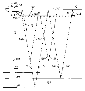
FIG. 1 shows an example of acquiring marine seismic data that can be used with
methods according to the invention. A seismic vessel 101 moves along the
surface 108 of a
body of water 102 above a portion 103 of the subsurface that is to be
surveyed. Beneath the
water bottom 104, the portion 103 of the subsurface contains rock formations
of interest such
as a layer 105 positioned between an upper boundary 106 and lower boundary 107
thereof.
The seismic vessel 101 has disposed thereon seismic acquisition control
equipment,
designated generally at 109. The seismic acquisition control equipment 109
includes (none
shown separately) navigation control, seismic energy source control, seismic
sensor control,
and signal recording equipment, all of which can be of types well known in the
art.
The seismic acquisition control equipment 109 causes a seismic source 110
towed in
the body of water 102 by the seismic vessel 101 (or by a different vessel) to
actuate at
selected times. The seismic source 110 may be of any type well known in the
art of seismic
acquisition, includin, air guns or water guns, or particularly, arrays of air
guns. One or more
seismic streamers 111 are also towed in the body of water 102 by the seismic
vessel 101 (or
by a different vessel) to detect the acoustic wavefields initiated by the
seismic source 110 and
reflected from interfaces in the environment. Although only one seismic
streamer I11 is
shown in FIG. 1 for illustrative purposes, typically a plurality of laterally
spaced apart
seismic streamers 111 are towed behind the seismic vessel 101. The seismic
streamers 111
contain sensors to detect the reflected wavefields initiated by the seismic
source 110. In the
present example the seismic streamers 111 contain pressure responsive sensors
such as
hydrophones 112, and water particle motion responsive sensors such as
geophones 113. The
hydrophones 112 and geophones 113 are typically co-located in pairs or pairs
of sensor arrays
at regular intervals along the seismic streamers 111. However, the type of
sensors 112, 113
and their particular locations along the seismic streamers 111 are not
intended to be
limitations on the scope of the present invention. It is to be clearly
understood that the
pressure responsive sensor can be any type of device that generates a signal
related to
pressure in the water or its time gradient. Correspondingly, the motion
responsive sensor can
be any device that responds to motion, acceleration or velocity. Non-limiting
examples of
such devices include velocity sensors (geophones) and accelerometers.
Each time the seismic source 110 is actuated, an acoustic wavefield travels in
spherically expanding wave fronts. The propagation of the wave fronts will be
illustrated
4
CA 02677008 2009-08-28
herein by ray paths which are perpendicular to the wave fronts. An upwardly
traveling
wavefield, designated by ray path 114, will reflect off the water-air
interface at the water
surface 108 and then travel downwardly, as in ray path 115, where the
wavefield may be
detected by the hydrophones 112 and Qeophones 113 in the seismic streamers
111. Such a
reflection from the water surface 108, as in ray path 115 contains no useful
information about
the subsurface formations of interest. However, such surface reflections, also
known as
ghosts, act as secondary seismic sources with a time delay from initiation of
the seismic
source 110.
The downwardly traveling wavefield, in ray path 116, will reflect off the
earth-water
interface at the water bottom 104 and then travel upwardly, as in ray path
117, where the
wavefield may be detected by the hydrophones 112 and geophones 113. Such a
reflection at
the water bottom 104, as in ray path 117, contains information about the water
bottom 104.
Ray path 117 is an example of a"primary" reflection, that is, a reflection
originating from a
boundary in the subsurface. The downwardly traveling wavefield, as in ray path
116, may
transmit through the water bottom 104 as in ray path 118, reflect off a layer
boundary, such
as 107, of a layer, such as 105, and then travel upwardly, as in ray path 119.
The upwardly
traveling wavefield, ray path 119, may then be detected by the hydrophones 112
and
geophones 113. Such a reflection off a laver boundary 107 contains useful
information about
a formation of interest 105 and is also an example of a primary reflection.
The acoustic wavefields will continue to reflect off interfaces such as the
water
bottom 104, water surface 108, and layer boundaries 106, 107 in combinations.
For example,
the upwardly traveling wavefield in rav path 117 will reflect off the water
surface 108,
continue traveling downwardly in ray path 120, may reflect off the water
bottom 104, and
continue traveling upwardly again in ray path 121, where the wavefield mav be
detected by
the hydrophones 112 and geophones 113. Ray path 121 is an example of a
multiple
reflection, also called simply a "multiple", having multiple reflections from
interfaces.
Similarly, the upwardly traveling wavefield in ray path 119 will reflect off
the water surface
108, continue traveling downwardly in ray path 122, may reflect off a layer
boundary 106
and continue traveling upwardly again in ray path 123, where the wavefield may
be detected
by the hydrophones 112 and geophones 113. Ray path 123 is another example of a
multiple
reflection, also having multiple reflections in the subterranean earth.
5
CA 02677008 2009-08-28
For purposes of the present invention, the ray path of principal concern is
the
reflection of seismic energy from the water surface in the vicinity of the
hydrophones 112
and geophones 113. Such reflection causes attenuation of certain frequencies
of the seismic
energy as detected by the hydrophones 112. Methods according to the invention
make use of
the signals detected by the geophones 113 to reduce the effects of such "ghost
notch" in the
hydrophone signals.
For purposes of simplifying the following explanation, the terms "hydrophone"
and
"geophone" will be used as shorthand descriptions for the types of signals
being processed. It
is to be clearly understood that the terin "hydrophone" in the following
description is
intended to mean a signal detected by any form of pressure responsive or
pressure time
gradient responsive sensor. Correspondingly, "geophone" " signals are interned
to mean a
signal detected by any form of particle motion responsive sensor, including
accelerometers,
velocity meters, geophones and the like.
A method according to the invention begins using the recorded hydrophone and
geophone signals corresponding to each actuation of the source. The recordings
should be
compensated for their respective sensor and recording channels' impulse
responses and the
transduction constant of each type of sensor used. Each such record of
hydrophone and
geophone recordings corresponding to a particular actuation of the source may
be referred to
as a "common shot" record or common shot "gather." The signal recordings may
be indexed
with respect to time of actuation of the seismic source, and may be identified
by the geodetic
position of each seismic sensor at the time of recording. The geophone signals
may be
normalized with respect to the angle of incidence of the seismic wavefront
detected by each
geophone. See, for example, U.S. Patent No. 7,359,283 issued to Vaage et al.
and assigned to
an affiliate of the assignee of the present invention for a description of
such normalization.
The hydrophone response is substantially omni-directional and does not require
correction or
normalization for anQle of incidence.
Referrin6 to FIG. 2, a flow chart outlining an example process for using
geophone and
hydrophone signals may include, at 21, transforming the hydrophone and
C'eophone signals
from the space-time domain to the frequency-wavenumber (f - k-.) domain. At 22
in FIG. 2,
the transformed hydrophone and geophone signals, H(f k) and G(t; k),
respectively, from the
domain transform at 21 are corrected for relative differences between the
sensor transfer
functions, which correspond to sensor impulse responses in the time domain.
Such
6
CA 02677008 2009-08-28
corrections could include, for example, correcting the amplitude and phase of
the hydrophone
signals to match the geophone signals, correcting the (leophone signals to
match the
hydrophone signals, or correcting both sets of signals to a common basis.
Correcting for
relative differences in sensor impulse responses is well known in the art.
Finally, an
amplitude scaling equal to the inverse of the acoustic impedance in the water
may be applied
to the geophone signals to correct for the relative differences in amplitudes
of pressure and
particle velocity. Such scaling is also well known in the art.
At 23 in FIG. 2, the corrected geophone signals from 22 are further corrected
for
angle of incidence. While a hydrophone records the total pressure wavefield, a
vertical
aeophone will only record the vertical component of the particle motion
wavefield. The
vertical part will be equal to the total particle motion wavefield only for
signals which are
propagating vertically, i.e. for which the angle of incidence equals zero. For
any other angle
of incidence the geophone signals need to be scaled, for example,
substantially as described
in the Vaage et al. `283 patent.
At 24 in FIG. 2, a low frequency part of the geophone signal can be calculated
or
estimated from the recorded hydrophone signal. The foregoing may also be
performed
substantially as explained in the Vaage et al. `283 patent.
At 25 in FIG. 2, a full bandwidth geophone signal can be calculated or
estimated by
merging the calculated low frequency portion thereof with the measured
geophone signals in
an upper part of the frequency spectrum, including some overlap. The foregoing
may also be
performed substantially as explained in the Vaage et al. 4283 patent.
At 26 in FIG. 2, a full bandwidth geophone data set and the recorded
hydrophone data
set are added or subtracted to calculate a full bandwidth up-going and down-
going wavefield.
The foregoing can be performed substantially as explained in the Vaage et al.
`283 patent.
A result of combining the full bandwidth geophone signals with the hydrophone
signals is an upgoing pressure wavefield that has reduced effect of the
surface ghost. More
specifically, the frequency filtering effect of the surface ghost is reduced.
The combined
geophone and hydrophone signals may be interpreted to determine two way
seismic energy
travel times from the water surface to seismic reflectors in the subsurface,
e.g., 104, 106 and
107 in FIG. 1. Using such two way travel times, it is possible to estimate
formation quality
factor ("Q") for subsurface formations occurring between two two-way
reflection times, tl
7
CA 02677008 2009-08-28
and tz. Amplitude of seismic energy as a function of frequency is related to
attenuation
characteristics of the subsurface formations as shown in the following
expressions:
A(.f)=A,(.f)eXp -'N2
(1)
o = - 1 In A (.f)
,7f (t, - ti) A, (.f)
If both sides of the second expression for Q above are multiplied by the
frequency f,
the resulting expression is:
- 1 in{A'(f)' =Qf (2)
77(t,-t,) A,(f)
The above expression is a form of equation of a straight line in the amplitude-
frequency plane, that is, it has the form:
v=mf+b
in which Q is the slope of the line and the intercept, b, (at frequency of
zero) is equal
to zero. Therefore, to estimate the Q of the subsurface formations from
seismic data between
selected seismic events, e.g., reflection times tl and t2, the amplitude
spectra (magnitudes of
the complex spectra) may be computed from two selected length data windows
centered on
each of the two selected seismic events (reflection times). The amplitude
spectra at each time
may be represented by At(f) and AZ(f). Using the amplitude spectra, the
function of frequency
on the left-hand side of equation (2) above may be calculated, and a straight
line may be fit
(such as by least squares) to the amplitude spectra function. The slope of the
best-fit line is
an estimate of Q for the subsurface formations disposed between seismic
reflection times tl
and tz.
In practice however, the linear regression as described in the application
never
assumes the intercept b is zero. The slope (m) from which Q is derived is
calculated as if
there were a non-zero value of the intercept, b, although the intercept itself
is never explicitly
calculated The reason for considering a non-zero intercept is that amplitudes
are typically not
properly balanced and the spectral ratios therefore do not cancel out at zero
frequency. The
intercept could also be calculated and could be used to exactly calibrate the
amplitude.
8
CA 02677008 2009-08-28
Using hydrophone-only streamers as is known in the art produced intercept
calculations that were considered even more unreliable than calculations of
the slope, which
calculations themselves were considered unreliable using hvdrophone-only
streamers. The
additional low frequency content provided by using streamers having both
pressure
responsive sensors and motion responsive sensors, and combining the pressure
and motion
signals as explained herein makes the intercept calculations substantially
more reliable.
Thus, using combined pressure responsive and motions responsive signals is
believed to
provide more accurate estimation of the slope and intercept of the amplitude
spectra. The
foregoing would provide not only better estimates for Q but also the
opportunity to precisely
calibrate seismic signal amplitude decay.
FIG. 3 shows, at curve 40, an amplitude spectrum of a typical marine seismic
source
towed at 7 meters depth, normal incidence, at an acquisition depth of about 8
meters. Energy
at 0 Hz and about 107 Hz is suppressed due to the water surface reflection
near the seismic
source (the "source ghost"). The receiver ghost imposes spectral notches at 0
Hz and about
94Hz. Also shown is the amplitude spectrum, at curve 42, for seismic signals
recorded from
the same source, but with the filtering effect of the receiver ghost removed.
The spectrum of
curve 42 has been multiplied by two to facilitate comparison.
The modeled amplitude spectra shown in FIG. 3 are shown in FIG. 4 at 44 and
46,
having been modified by an earth filter having response characteristics shown
by line 48.
FIGS 5A and 5B show, respectively, example amplitude spectra for a
contemporaneously acquired up-going pressure wavefield (50 in FIG. 5A), and
total pressure
wavefield (52 in FIG. 5B). The forgoing amplitude spectra are consistent with
the modeling
shown in FIG. 4, and demonstrate that the amplitude gradient with respect to
frequency
cannot easily be estimated from the total pressure field data. The receiver
ghost must be
removed, which can be readily performed using data from a dual sensor
streamer.
While the invention has been described with respect to a limited number of
embodiments, those skilled in the art, having benefit of this disclosure, will
appreciate that
other embodiments can be devised which do not depart from the scope of the
invention as
disclosed herein. Accordingly, the scope of the invention should be limited
only by the
attached claims.
9