Note: Descriptions are shown in the official language in which they were submitted.
CA 02679415 2009-08-28
WO 2007/102129
PCT/1B2007/050764
1
10 ROCK CORE LOGGING
FIELD OF THE INVENTION
The invention relates to a method for logging data from drilled core samples
of
rock. The invention extends to a software program, and to a computer readable
medium and a combination of hardware.
BACKGROUND TO THE INVENTION
The successful exploration for, delineation of, and eventual mining of ore-
bodies, as well as the safe construction of massive structures such as high
rise
buildings and dam walls, and tunneling for civil works etc. are all dependent
on
a thorough knowledge of the geology of the ground. A three-dimensional (3D)
understanding of the subsurface is developed from surface geological mapping,
along with geophysical and geochemical surveys. However, the predictive
power of such three-dimensional models is substantially limited without data
from reliable and accurate measurements derived directly from the subsurface.
Various drilling techniques (such as diamond drilling) are used to bore deep
into
the earth with the aim of producing continuous cylinders of rock, termed
"core",
which samples are then measured and described in a process known as "core
logging". These data are then processed and analyzed to refine the three-
dimensional modeling as well as determine such parameters as ore body size
and grade, or the potential for other "hidden" ore deposits/extensions, as
well as
CA 02679415 2009-08-28
WO 2007/102129
PCT/1B2007/050764
2
blasting requirements, rippability of the rock and rock mass behavior
characteristics (such as slope stability, fragmentation, flow or creep etc.)
when
excavating or loading with additional weight and so on.
Core logging entails the measurement and detailed description of a wide range
of features ¨ the lengths of lithological and alteration intervals for
example, the
densities of the different rock types intersected, their uniaxial compressive
and
tensile strengths, the shear strengths of any contained discontinuities, as
well
as the attitude of all structures, both planar (bedding, fractures, joints
etc.) and
linear (fault slickensides, acicular mineral alignment etc.) relative to the
core
axis. Additional tasks include evaluating the length of missing sections of
core
due either to natural cavities or mechanical grinding and poor drilling
practice
and defining the lengths of solid core versus rubble or matrix, or badly
fractured
and/or friable rock.
Current core logging methods do not achieve optimum results. They are largely
manual in that data is handwritten on either standard or customized logging
forms. These data are then clerically entered into a computer data base and
returned to the geologist for editing, validation and processing. This time
consuming process is fraught with transcription, editing and audit errors, to
the
detriment of both the drilling program and the ground interpretation/modeling
exercise.
Three-dimensional ground modeling is further severely hampered by the fact
that the collection of subsurface structural data is still erroneously
considered
too specialized and expensive to run routinely. In reality only two procedures
to
prepare the core for such measurements are needed. Firstly, the intersection
of
the in-situ geographic vertical plane with the rock core has to be marked
along
the surface of the cylinder. Several different instruments can be used to
indicate the position of such a reference line, which when drawn on the core
is
known as an "orientation line". Then the attitude, or inclination, of the core
axis
has to be surveyed along the entire length of the bore, which data together
with
measurements of the down-hole change in core axis direction, or azimuth, is
known as a "borehole survey". Given this information the angular attitude of
CA 02679415 2009-08-28
WO 2007/102129
PCT/1B2007/050764
3
planar or linear structures found in the core can be measured relative to the
core axis and orientation line, and the results computed to derive the actual
in-
situ dip and dip direction, or plunge and trend of the planar and linear
geological
structures respectively.
The borehole survey is also required in order to calculate the geographic
coordinates of features logged in the core, before the data can be processed
to
construct a meaningful three-dimensional model. Such modeling then requires
statistically valid data to develop a reliable schematic of the ground. One of
the
main tools for statistically analyzing three-dimensional geological data is
the
stereographic projection, or Stereonet, on which the geologist should plot
each
and every structural data reading. The resulting Stereoplot is then contoured
from which statistically valid mean values are derived for the various planar
and
linear structures logged in the core.
This systematic processing approach enables filters to be applied to the data
at
any stage of the logging process not only to evaluate accuracy, but also to
display how the structures (faults, joints, shears etc.) change with depth in
the
ground as well as how they are influenced by the different lithologies, rock
properties etc.
OBJECT OF THE INVENTION
It is an object of the present invention to provide a method of rock core
logging
and associated software program which facilitate the direct, digital recording
of
details of a core sample, together with data processing and analysis. A core
tray
frame and core tray suited to this are also provided.
SUMMARY OF THE INVENTION
In accordance with this invention there is provided a method of logging rock
core, which includes taking a digital photograph of core from a borehole and
recording structural measurements of features of the core from the photograph
using a computer.
CA 02679415 2009-08-28
WO 2007/102129
PCT/1B2007/050764
4
The invention further provides for the photograph to be taken of a series of
rock
core runs; for a longitudinal reference line to be drawn along the core; and
for
the line to be an orientation line (marking the intersection of the in situ
geographic vertical plane with the surface of the rock core).
Further features of the invention provide for the structural measurements to
include linear rock interval measurements and/or angular measurements of
geological structures (structural planes or lineations); for the linear
measurements to include the depth of each core run and the depth of each
geological structure; and for the angular measurements to include a angle, 13
angle and/or 0 angle of geological structures.
Further features of the invention provide for the photograph to be calibrated
to a
measurement scale; for the measurement scale to be photographed with the
core; for the photograph to be corrected for radial distortion, pitch
distortion
and/or yaw distortion; for the photograph to be corrected for depth
perspective
(the vanishing point of the image); for a correction scale to be included in
the
photograph to make corrections for radial distortion, pitch distortion, yaw
distortion and/or depth perspective; and for the photograph to be marked for
corrections relating to at least depth perspective. Such un-distortion and
correction allows the two-dimensional image to be used as a virtual three-
dimensional model of the core enabling accurate length and angle
measurements to be made from the image.
Further features of the invention provide for a reference frame to be used to
provide a measurement and correction scale; and for the frame to extend along
the length and width of a core tray. The scale is preferably provided by a
rock
core tray frame which includes an upper surface having indicators with known
dimensions.
A further feature of the invention provides for the core to be photographed
with
core blocks indicating depth between each run. These depths will be provided
as readings taken by the driller.
CA 02679415 2009-08-28
WO 2007/102129
PCT/1B2007/050764
A further feature of the invention provides for the manually logged data to be
collected and compared to the structural measurements from the photograph.
5 In accordance with another aspect of this invention there is provided a
software
program enabled to receive a digital image of rock core from a borehole and to
make structural measurements of features of the core from the image.
The invention further provides for the software program to calibrate the image
to
a measurement scale; for the software program to be enabled to register
indicators on a correction scale and to correct the image for depth
perspective,
radial distortion, pitch distortion and/or yaw distortion; for the software
program
to automatically calibrate the image to a measurement scale and/or correct the
image to a correction scale for depth perspective, radial distortion, pitch
distortion and/or yaw distortion; and for the software program to mark the
image
for corrections relating to at least depth perspective.
A further feature of the invention provides for the image to be taken of
series of
rock core runs and a measurement and/or correction scale.
Further features of the invention provide for the structural measurements to
include linear rock interval measurements and/or angular measurements of the
geological structures; for the structural measurements to include the depth of
each core run; and the depth, a angle, 13 angle and/or 0 angle of a geological
structure (structural plane or lineation).
Further features of the invention provide for the software program to enable
marking of the image over geological structures and/or the ends of core
segments; for the length of each segment of core and the depth of each
geological structure in the image to be measured; and for the software program
to provide a depth registration of the total core length (from collar to end-
of-
hole); and for the software program to incorporate in the depth registration
details of core loss/gain along the length of the bore.
CA 02679415 2009-08-28
WO 2007/102129
PCT/1B2007/050764
6
A further feature of the invention provides for the angular and/or linear
measurement results to be permanently stored on the image in the form of
markings, at the ends of core segments and structures measured in the core,
and coded tags, on each segment for interval (lithological, physical
characteristics) data. The markings are preferably coloured traces overlying
the
ends of core segments and structures measured in the core.
A further feature of the invention provides for the software program to be
enabled to import manually logged angular (structural) and/or linear interval
(lithological) data for comparison to data logged by the software program; and
for the software program to display the imported data on the image. In the
case
of structures the results are displayed as digital coloured traces overlying
the
planes in the core and in the case of interval data each core segment is
flagged
with a coded tag. This aspect allows for full visual validation of the data
and for
immediate correction of any discrepancies (the invention thus provides for the
importation and auditing of manually logged data).
The invention extends to a computer readable medium carrying the software
program as defined above and a combination of hardware enabled by the
software program defined above.
In accordance with another aspect of this invention there is provided a method
of logging rock core comprising, taking a digital photograph of rock core,
sending the photograph to an image processing computer where the image is:
calibrated to a measurement scale;
corrected for radial distortion, pitch distortion and/or yaw distortion; and
corrected for depth perspective
and returning the image from the processing computer for recording structural
measurements of features of the core using a logging computer.
The invention further provides for the photograph to be marked by the
processing computer for corrections relating to at least depth perspective.
CA 02679415 2009-08-28
WO 2007/102129
PCT/1B2007/050764
7
Further features of the invention provide for the image to be marked with
indicators on a reference frame and/or on the core and for the processing
computer to recognize the indicators and to automatically:
calibrate the image;
.. correct the image for radial distortion, pitch distortion and/or yaw
distortion;
mark the image for corrections relating to at least depth perspective; and
depth register the core.
The length of each segment of core in the image is digitised and measured, and
a depth registration of total core length (from collar to end-of-hole),
incorporating details of zones of core loss/gain along the length of the bore
is
provided.
Further features of the invention provide for the image to be transmitted to
and
.. from the processing centre via a communication network; and for the network
to
include the Internet.
In accordance with another aspect of this invention there is provided an image
processing software program that will receive a digital image of a series of
rock
.. core runs from a borehole and enabled to:
calibrate the image to a measurement scale;
correct the image for radial distortion, pitch distortion and/or yaw
distortion; and
correct the image for depth perspective.
.. A further feature of the invention provides for the processing software
program
to store data relating to indicators on a reference frame and to automatically
calibrate and correct the image from the stored data; and for the software
program to enable marking of the image with traces over the geological
structures and/or the ends of core segments.
In accordance with another aspect of this invention there is provided a rock
core
logging software program that will receive a digital image processed by the
processing software program defined above and enabled to make linear and/or
angular measurements of the core features from the image.
CA 02679415 2009-08-28
WO 2007/102129
PCT/1B2007/050764
8
A further feature of the invention provides for the logging software to
recognize
traces and/or markings in the processed image and to automatically calculate
at
least some of the measurements. (This avoids the step of adding relevant
markings as part of the logging procedure.)
Further features of the invention provide for at least some of the markings to
be
provided on the core prior to photography and/or by indicators provided on a
core tray or a reference frame and/or by depth markers provided by core
blocks.
Markers on the core can be made manually and will include an orientation line
and traces or markings traced over structures on a core sample.
In accordance with another aspect of this invention there is provided a rock
core
tray frame having indicators with known dimensions.
The invention further provides for the indicators to provide a calibration
scale
and a correction scale.
Further features of the invention provide for the frame to be rectangular with
indicators on an upper surface marking intersections of length and breadth
adjacent corners of the frame.
Further features of the invention provide for orthogonal lines to provide the
indicators on the surface between the intersections of length and breadth; for
the indicators to include lines extending across elevated portions parallel to
the
upper surface of the frame; and for the portions to be steps on the upper
surface providing elevated surfaces.
Further features of the invention provided for the mid-points of the length
and
breadth to be marked with indicators; and for the elevated portions to be
provided to either side of the mid-points.
Further features of the invention provide for the frame to have adjustable
supports; for the support to be extensible legs; and for the legs to have a
screw
CA 02679415 2013-02-04
, .
9
threaded connection to the frame. This provides for the upper surface to be
lined up
with the top sides of core samples in a core tray.
Further features of the invention provide for the indicators on the frame to
be suited
for recognition in a digital image by a software program; and for the frame to
be
white and/or the indicators primary colours.
Accordingly, in one aspect the present invention resides in a method of
logging rock
core, which includes taking a digital photograph of core from a borehole to
provide a
two-dimensional image of the core and operating a computer to: analyze the two-
dimensional image and provide a virtual three-dimensional model of the core
from
the photograph; and record measurements of features of the core from the
model.
In another aspect, the present invention resides in a computer enabled by a
software program and operated to receive a digital image of rock core from a
borehole, to calibrate the image to a measurement scale and to make linear
rock
interval measurements and angular measurements of geological structures of the
core from the image.
In a further aspect, the present invention resides in a rock core tray frame
for use in
the aforementioned method comprising a reference frame having indicators with
known dimensions providing a measurement scale and a correction scale which is
locatable around a core tray and used to calibrate a photograph to the
measurement
scale and correct the photograph for depth perspective, radial distortion,
pitch
distortion and/or yaw distortion.
BRIEF DESCRIPTION OF THE DRAWINGS
These and other features of the invention will now be described, by way of
example
only, with reference to the accompanying drawings, in which
CA 02679415 2013-02-04
9a
Figure 1 shows a schematic illustration of a method of logging rock
core;
Figure 2 shows an illustration of a photograph of a series of core
runs;
Figure 3 shows another schematic illustration of a method in accordance
with
this invention;
Figure 4 shows an arrangement of equipment for photographing core samples;
Figure 5 shows perspective view of a core tray reference frame;
Figure 6 shows part of a processed digital image of a core tray with
core
positioned within a core tray frame;
Figure 7 shows a photograph image in the process of calibration and
correction;
Figure 8a shows a calibrated and corrected version of the image in
Figure 7;
Figure 8b shows a magnified portion of the image in Figure 8a;
Figure 8c shows a further magnified portion of the image in Figure 8a;
Figure 9a shows a processed digital image of core samples imported to a
software program;
Figure 9b shows a magnified portion of a processed image like that in
Figure 9a;
Figure 9c shows the image of Figure 9b with a trace being edited;
Figure 10 shows an illustration of a and 13 angles;
25
CA 02679415 2009-08-28
WO 2007/102129
PCT/1B2007/050764
Figure lla shows a schematic illustration for the calculation of a and
13
angles for a planar feature using a software program;
Figure llb shows a portion of an image as represented by Figure 10a;
Figure 12 shows a schematic illustration for the calculation of a and
13
5 angles for a planar feature;
Figure 13 shows a schematic representation for the calculation of a and
0
angles for a lineation;
Figure 14 shows a schematic representation for angular calculations
relating to non-penetrative lineations;
10 Figure 15 show a schematic representation for angular
calculations
relating to penetrative lineations;
Figure 16 shows schematic representations for an alternative
calculation of
a, 13 and 0 angles;
Figure 17 shows a window for entering details into the software
program;
Figure 18 shows some of the details logged on the software program and
plotted on a Stereonet; and
Figure 19 shows three tables for use in recording borehole details.
DETAILED DESCRIPTION OF THE INVENTION
Referring to Figure 1, the current invention involves using a digital
photograph
(1) of rock core (2) from a borehole for logging of structural data. The image
(1)
is taken using a suitable digital camera (A) and downloaded to a data
processor
or computer (B) for analysis using a software program which is also part of
this
invention. Incorporated in the image (1) is a suitable measurement and
calibration scale (C) which is located next to the core (2). The measurement
scale is a ruler (4), in either metric or imperial measure, for calibrating
pixel size
to standard measure. Shown more clearly in Figure 2, the reference scale is
represented by three pyramids (5) of known dimension and spacing. The
pyramids (5) are located symmetrically at three corners of a core tray (6),
with a
pair of rulers (4) extending therebetween. The points (3) of the pyramids (5)
are
lined up with outer edges of the rulers (4).
CA 02679415 2013-02-04
s
11
During a drilling operation, a driller will produce a series of core runs (2)
in the usual
manner. Once removed from the core-barrel, the core (2) is laid out on an
angle iron
(not shown) and marked with a reference line (7) along its length. If
oriented, this will
be the orientation line (7) which normally represents the bottom side of the
core (2)
in the geographical vertical plane (depending on the orientation method used).
Each run of core (2) can then be photographed to provide a separate image.
However, a number of core runs (2) are preferably transferred to a core tray
(6), with
the reference line (7) visible and as close to the crests of the core segments
as
possible, and then photographed, as shown in Figure 2.
Most of the data will be recorded using a cursor on the computer screen and
"clicking" onto visible structure of the image (1) using a "mouse". The image
(1),
which is taken by the digital camera (A), will be calibrated by clicking on
spaced
apart points corresponding to a specific measurement. These will conveniently
be
the points (3) of the pyramids (5) which are located as accurately as possible
in the
same plane as the crests of the core (2).
The image (1) is also corrected for radial distortion, pitch distortion and
yaw
distortion as well as for depth perspective. This is done using the pyramids
(5). The
relative offset of each pyramid point (3) as seen in the image (1) from the
centre of
each side of the pyramid base is used for this. The distance between the
points (3)
and base is also known. These corrections are significant for the angular
calculations which are discussed below.
The calibration and un-distortion or correction, allows the two-dimensional
image (1)
to be used as a virtual three-dimensional model of the core (2) enabling
accurate
length and angle measurements to be made from the image (1). More
particularly,
these are angular measurements of geological structures (structural planes or
lineations) and linear rock interval measurements. The angular measurements
include calculation of the alpha (a) angle, beta (6) angle and/or theta (El)
angle of a
geological structure. The linear measurements
CA 02679415 2009-08-28
WO 2007/102129
PCT/1B2007/050764
12
include the depth of each core run and the depth of each geological structure.
The measurements referred to will be described in more detail in what follows.
The invention involves a method of logging designed to provide accurate
geotechnical data that is fully auditable from oriented rock core. More
particularly, digital photography of the core is processed to remove radial
(lens)
distortion, correct pitch and yaw perspective, and compensate for depth
perspective. This is done to enable: (a) precise depth measurement, (b)
accurate a and 13 angle measurement of all planar structures in the rock as
well
as 0 angle measurement for linear features and (c) comprehensive description
of the core.
In a development of the invention, digital photographs taken of the core in a
core tray with a suitable reference frame are calibrated and corrected, as
described below, using a dedicated image processing software program. The
processed images are then, together with the relevant driller's log, imported
into
a separate logging software program for recording details from the images.
This
is illustrated with reference to Figure 3. The processing software is loaded
onto
a first computer (E) and the logging software onto a second computer (F).
It will however be appreciated that the image processing and logging software
can be integrated as a single program loaded onto a single computer (B) as
shown in Figure 1.
A permanent visual record and reliable means of rapidly assessing the accuracy
and quality of the data is provided in the recorded image (1). This can be
seen
in Figure 9 where such an image is shown as part of a screen in the logging
software program.
Details are reflected on the image (1) and also in data sets or tables of the
logging software program. In addition, the data will be analyzed in
conjunction
with the borehole survey and plotted incrementally on a Stereonet and in any
other useful manner that may be required. Different views of the image with
CA 02679415 2009-08-28
WO 2007/102129
PCT/1B2007/050764
13
markings and details can be selected. It can therefore be viewed with no
markings or only markings and details of a specific category if that is
desired.
Other recorded details, for point and interval logs as described below, can be
viewed by locating a computer cursor over the relevant portion of core (or on
a
marker for the portion). A pop-up list or coded tags with the information will
then
appear on the computer screen.
Furthermore, all manual measurements taken from the core (separate from the
image processing and computer logging) are imported into a data set and are
also displayed in their correct depth locations on the image. This enables
full
auditing of all such manual logs.
Customizable pop-up window forms are used for comprehensive description of
each of the fractures or structural planes so that all geotechnical detail is
immediately recorded in the database.
The method of the invention may be implemented as a system divided into the
following five phases:
(i) Core preparation - this requires close monitoring by the geologist
involved to
ensure that the driller delivers quality core from a bore that is on target;
(ii) Core photography - To be carried out as soon as possible after the core
has
been loaded into the core tray before it is degraded by transport and
weathering, etc.;
(iii) Image processing and logging - undertaken by trained operatives using
the
image processing and logging software (these people are preferably chosen for
their meticulous attention to detail and abilities to consistently produce
accurate
depth registered images with good structural detail processing);
(iv) Descriptive core logging - normally done in the core shed. Since linear
and
angle measurement of the core is taken care of in the image processing phase,
CA 02679415 2009-08-28
WO 2007/102129
PCT/1B2007/050764
14
the geologist can now concentrate on adding accurate and detailed descriptions
of the various core features to the database using the logging software; and
finally
(v) Data analysis phase ¨ for this a borehole survey must be loaded onto the
logging software to rotate the raw data and automatically plot the Stereonet
which actively updates as each new data set is added.
Given regular single shot surveys as drilling progresses the "data analysis
phase" enables a geologist to monitor the development of the Stereoplot (data
plotted on the Stereonet) and investigate any unexpected data points to ensure
their validity and if necessary correct any improper core orientation, for
example, before it becomes a serious issue.
To begin with, the quality of any geotechnical data derived from core is
greatly
dependent on the quality of the drilling. The geologist involved should
monitor
this to minimize detrimental aspects such as: grinding or mechanical damage
(apart from that necessary to break the core at the end of a drill run or to
fit into
the core tray); borehole deviation from target; good depth control for
accurate
marking of the core blocks; reliable core orientation, etc.
The current system offers on-site procedural training for the geologist as
well as
various aids that have been devised to ensure that core delivery is of the
highest standard. This will include recording information such as that
provided
for in Tables 1, 2 and 3 of Figure 19.
Once the core (2) has been recovered to surface it is assembled on a suitable
length angle iron and marked up with the orientation line (7). All breaks are
then
marked with a proper description (such as natural, mechanical or due to
grinding, washed away etc.). The recovery is measured and the core
photographed before packing it into a core tray. Any subsequent unmarked
breaks can thus be confidently treated as mechanical.
CA 02679415 2013-02-04
Referring to now to Figure 3, the core (2) is photographed in a core tray (6)
on a flat
concrete slab in a well lit area, but not in direct sunlight. A digital camera
(A) is
preferably mounted on a tripod (8) such that it is relatively horizontal and
central to
the tray (6).
5
Figure 4 shows the camera tripod and lighting setup. A fluorescent light (9)
is
included. Core blocks (10) are turned so that the depth marked on each is
clearly
visible in the photograph image (1). A rigid, calibration and correction frame
(11) is
placed around each tray (6) for the photograph (1).
The frame (11) which is shown more clearly in Figure 5 can be made from angle
iron welded to provide the required rectangular form. Brackets (12) are
attached on
the upper surface (13) of the frame (11) to either side of the corners (14)
and to
either side of the mid-points (15) along the length, or long sides (16), of
the frame
(11). The brackets (12) are provided by inverted sections of channel iron.
These
brackets (12) provide twelve elevated surfaces (17) that are parallel to the
upper
surface (13) of the frame (11) on which they are mounted. The frame (11) is
painted
white.
The reference frame (11) is marked along the centre of the upper surface (13)
with
orthogonal lines (18), which cross each other at (19) adjacent the corners
(14) of the
rectangular frame (11). It is also marked with crosses (20) at the mid-points
of each
side (length and width). These indicators provide a calibration and correction
scale,
the significance of which will become further apparent from what follows.
The lines (18) and crosses (20) on the upper surface (13) are green. Blue
lines (21)
on the elevated surface (17) of each of the brackets (12) are provided
vertically
above the green lines (18) and (20) which extend along the frame (11) below.
The digital image (1) is imported to the processing software on computer (E).
The
image processing program will request the length and width of the frame (11)
between the crosses (19). In this example, the values are 1.623 m and
CA 02679415 2013-02-04
16
0.44 m. The diameter of the core is also provided. The image (1) is then
calibrated
by clicking the cursor from corner (19) to mid-point (20) to corner (19)
indicator, on
each of the cross markings on the frame (11) in sequence as prompted by the
software program. The prompts require, in addition to each of the corners
(19), for
the four mid-point (20) indicators to also be clicked. When this is done, a
red cross
(22) is left superimposed at each of the corners (19) and mid-points (20)
where the
cursor has been clicked. This is shown in Figure 7.
The relative displacements of the red crosses (22) at the corners (19) and mid-
points (20) in the image (1) in relation to the actual dimensions of the known
orthogonal reference frame (11) are used to remove radial distortion and
correct
pitch and yaw perspective in each image (1). This step is executed through the
image processing software and referred to as "un-distort" in this document. To
optimize this adjustment calculation, the frame (11) and core tray (6)
assembly are
arranged so that (i) the core (2) is turned so that the orientation line (7)
is clearly
visible in an upper position, as near as possible to the crest of each segment
(2) and
(ii) the upper surface (13) of the frame is level with the crests of the core
(2).
To achieve the latter, the frame (11) must be adjustable in its height
relative to the
tray (6) [or the tray needs to be configured for relative adjustment]. In this
embodiment the frame (11) has extensible legs providing adjustable supports
(not
shown). The legs can be bolts adjacent each of the corners (14) with a screw
threaded connection to the frame (11). This enables the upper surface (13) to
be
lined up with the top sides of core samples (2) in a core tray (6).
Once the image (1) has been corrected or un-distoretd, the software generates
green lines (23) across the image through red corner points (24) on the frame
(11).
It also generates blue lines (25) forming a rectangle across the image through
the
elevated blue lines (21) and crops the image (1) to what is seen in Figure 8a.
Where the lines (25) do not properly coincide with the lines (21) on the
brackets
(12), the sides (25) of the rectangle can be dragged into a correct overlying
position.
The lines (23) and (25) can be seen more clearly in Figure
CA 02679415 2009-08-28
WO 2007/102129
PCT/1B2007/050764
17
8h. This is the product that is imported to the logging program on computer
(F).
The red points (24) mark the positions of selected using the red crosses (22)
and remain on the image as an indication of accuracy.
It will be appreciated that alternative indicators on a frame (11) can be used
for
the calibration and correction. The frame (11) may also be made from any
suitable materials. It need not be rectangular and a close fit to a core tray
(6).
The frame (11) may therefore vary in its configuration as long as it provides
the
necessary reference indicators or points required by the image processing
software. Such a frame may also be made integral with a core tray or it may
consist of more than one part for arrangement around a tray. The brackets (12)
may also be inverted pieces of angle iron, with a blue line along the upward
facing ridge, located centrally along the frame (11).
With the current image processing software, the photograph (1) can be taken
with almost any digital camera from a reasonably central elevated position
over
the core tray (6). An image taken by hand standing over a core tray would be
sufficient for processing.
Furthermore, where the qualities or characteristics that a particular camera
and
lens impart to a captured image (such as radial distortion, pitch and yaw
perspective and depth perspective) are known, a scale is also not required to
be
included in the image. This is because the diameter of the core is known and
provides a reference for measurement. Where the height of the camera fixed
vertically above the core tray is known (i.e. distance from camera to core),
the
diameter of the can also be calculated.
After the photographs (1) have been processed they are imported into the core
logging software program. The generated green (23) and blue (25) lines, in the
corrected image (1), are detected and used to calculate the parameter required
in order to compensate the measurement for depth perspective in the image (1).
The images (1) are now available for logging, which must preferably be done
with the core (2) at hand for manual inspection. This is shown indicated by
(G)
CA 02679415 2009-08-28
WO 2007/102129
PCT/1B2007/050764
18
in Figure 3. The imported image (1) can be magnified on a computer screen if
that is required.
The first task is depth registration of the core (2) ¨ see Figure 9a. A depth-
reference line (26) is generated along each segment of core (2) in the image
(1). These lines (26) are to depth reference the core and create a "depth
log".
Where the core (2) is oriented the reference line (26) is generated, using the
logging program, directly over the orientation mark (7) on the photographed
core (2). This is done by clicking the computer cursor first at the upper end
and
then at the lower end of the core segment (where the orientation mark meets
the ends). The same marking (26) is made if the core (2) is not oriented.
However, in this case, an estimation of where the core axis lies is used to
generate the reference line (26).
A superimposed coloured reference line (26), in this example purple, will
appear
on the image (1) between the two points where the cursor was clicked. The
logging program then prompts a selection from the following:
Bottom marked with orientation line ¨ if selected, line (26) turns red;
Top marked with the orientation line ¨ line (26) turns pink;
No orientation line ¨ line (26) turns orange;
Matrix/rubble ¨ line (26) turns yellow.
Orange lines on the image (1) therefore denote sections of un-oriented core,
whereas a yellow line is used to demarcate zones of rubble or matrix. The
selection of these colours is only by way of example. The benefit or
convenience of such colour coding will however be appreciated.
The lengths of each individual solid and rubble section of core is recorded
and
numbered (not shown) on the image.
As mentioned, a marker or core block (10) reflecting a depth reading provided
by the driller will be positioned at the start of each run of core (2) before
the
CA 02679415 2009-08-28
WO 2007/102129
PCT/1B2007/050764
19
photograph (1) is taken. The depth of the bottom of the borehole is also known
from the length of the drill string.
The start depth of every run of core will be entered into the program manually
in
accordance with the depth marker (10). In the image (1) the core (2) is depth
referenced by clicking sequentially on the top (27) and bottom (28) ends of
the
reference line (7) on each run of core (2) or each individual segment of each
run
of core (2). The nearer the line (7) is to the crest of the core (2) the more
accurate will be the depth registration of the core.
By incrementing the lengths of each segment in the run the total core
recovered
for the run is computed. Each run of core (2) may, as already mentioned, exist
as more than one segment. Breaks in a core run (2) can result from the
drilling
or from naturally occurring cavities, joints or faults. Cavities will result
in core
loss but this can also happen where a driller has ground part of the core (2)
away. The difference between consecutive depth markers (10) and the advance
made in drilling the borehole will indicate where there has been core loss and
the extent thereof. The software program provides fields for manual readings
and notes based on a visual inspection. These readings are recorded to
account for the irregularities. Occurrences of core gain may also present
themselves and can be dealt with in the same manner. Gains in core result from
the mechanism used to recover the core run from the bore or where the depth
readings from the driller are incorrect.
This process of linear measurement and description enables automatic rock
quality designation ("ROD"). A cumulative total is calculated and
automatically
compared with the "Driller's Log", which will have already been loaded onto
the
software program. This is to ensure accuracy in allocating and classifying any
core loss at the end of every run. The length of the core stub left in-hole
will also
be computed, since the core block (10) depth records the depth of the cutting
edge of the drill bit and not the exact core break in the run.
The logging will preferably take place at the drill site and with the core (2)
shown in the image (1) being processed at hand. This is illustrated by (G) in
CA 02679415 2013-02-04
Figure 3 and by (D) in Figure 1. The visual inspection referred to can thus be
made
with respect to the image (1) as well as the core sample (2) itself.
After depth registration the next task is measuring the geological structures
found in
5 the core, which fall into two categories: planar and linear structures.
These are dealt
with separately below. All structures are picked and breaks in the core are
classified
as natural or mechanical breaks. The marks made on the core in the preparation
phase are used.
10 The term "picked" refers to selection of a structure followed by
recording of its
relative orientation using the logging program to enable calculation of a, 13
and 0
angles (as appropriate) and a description of its characteristics. The term
"pick" refers
to such an entry.
15 The program is thus suited for recording a "Point Log" for each
structure on a core
segment. This includes both healed structures and open structures at the ends
of a
segment of core (2).
All planar structures (29) have an elliptical outline in the core (2) as shown
in Figure
20 10. Such a structural plane (29) is thus also sometimes referred to as
an ellipse
(29) in this description. If the core (2) is oriented, measuring the attitude
of the
ellipse (29) relative to the core axis (30) and the known geographic vertical
plane
(31) enable these angles to be converted to the true in-situ dip and dip
direction of
the plane ¨ given survey data for the borehole path. The attitude of the
ellipse (29)
relative to the core axis (30) is conventionally termed the alpha (a) angle
(i.e. the
difference between the core axis and structural plane (29.1) of the ellipse).
The
attitude of the ellipse (29) relative to the known geographic vertical plane
(31) is
conventionally termed the beta (13) angle (i.e. the difference between the in
situ
vertical plane and the plane of the major axis (29.2) of the ellipse).
With reference to Figures 11 and 12, the un-distorted and corrected image (1)
provides a virtual three-dimensional representation of a cylinder of core (2).
The
diameter of the core (2) will be entered into the software program and
CA 02679415 2013-02-04
21
corresponds to the width of the core (2) shown in the image (1). A sliding
marker
(33) - also referred to hereinafter as a "slide" - is moved along the
reference line (26)
generated by the program using the cursor. The cursor is clicked on the slide
(33)
when it is over the point where the structure that is to be picked intersects
the
reference line (26) and a marker (32) is placed at this point. Note the line
(26)
should be superimposed on the orientation line (7) of a marked core (2). On a
second click of the cursor on the marked intersection point (32) of the
(oriented)
reference line (26) and the structural plane (29), the software will generate
three
lines (34), (35) and (36) parallel to the axis (30) of the core (2) over the
image (1).
The centre line (35) will be provided on the point (32) where the cursor was
clicked.
These parallel lines are equally spaced apart from the reference line (26).
More
specifically, the side lines (34) and (36) will be spaced apart from the
centre line (35)
by a distance equal to the radius of the core (2). This is the first position
of the lines
(34.1), (35.1) and (36.1). The distance between the parallel lines is thus
equal to the
diameter of the core (2), to which the image (1) is calibrated. However, the
core (2)
is not always arranged in the tray (6) with its orientation line (7) at an
apex position.
For this reason, the parallel lines do not always match up at the sides of the
core (2)
in the image.
The three lines (34.1), (35.1) and (36.1) are then dragged, using the cursor,
into a
second position (34.2), (35.2) and (36.2). These lines can be dragged either
up or
down, again using the cursor, until they are aligned with the sides of the
relevant
core segment (2). In the second position, lines (34) and (36) are aligned with
the
sides of the core (2). The slide (33) on the centre line (35.2) is again
located at the
intersection with the structure and the cursor clicked. The angle represented
by the
adjustment of the centre line (26) will be factored in as a correction in the
following
calculations of the program. The movement required provides a measure of the
offset of the oriented reference line (7) from the vertical plane as the core
(2) lies in
the core tray (4). This offset angle is then applied to the measurement and
computation of the beta (13) angle of the structure. Without the capability of
so
defining this offset, the core would have
CA 02679415 2013-02-04
22
to be placed in the tray with the reference line perfectly in the vertical
plane (i.e. at
the exact crest of the core cylinder) prior to the core being photographed.
Once lines (34) and (36) match the sides of the core segment, the cursor is
clicked
to fix them in position. Once the lines are set, and the cursor clicked, a
second slide
will appear on the top line. This is similarly located over the intersection
of the side
of the core with the structure and clicked. A third slide then appears on the
bottom
line. This is used to mark a third intersection and, once it is clicked, the
program
corrects the points for depth perspective and generates an ellipse in the form
of a
trace (37) through these three points or slides (b), (a) and (c), part of
which is seen
on the core (2) in the image (1). The cursor is in this way used to click on
the points
(b), (a) and (c) where the structural plane (29.1) intersects the three lines
(34.2),
(35.2) and (36.2). If the part-ellipse (37) coincides with the structure, the
three points
have been correctly located. The structure can be so recorded. The part-
ellipses or
traces (37) can be seen in Figure 9b.
Referring particularly to Figure 12, between the point (a) on the centre line
(35.2),
which is a point of origin, and the two points (b) and (c) on the side lines
(34.2) and
(36.2) are two vectors which lie in the structural plane (29.1). The 13 angle
is thus
computed by the software program. The two vectors are used to calculate a
vector
which is normal (the normal vector) to the structural plane. The normal vector
is
compared to the core axis (30) to provide the a angle of the structural plane
(29.1).
The exact shape of the ellipse (37) relative to the reference line (26) is
thus detailed
and the program automatically calculates the a and 13 angles.
The logging software program automatically generates a coloured trace, in this
example green, to overlie the structural planes [in other words, superimposed
as the
relevant part-ellipse (37)] as they are picked. This process therefore
displays the
green part-ellipses (37) on the image (1) which closely trace the outline of
the
structures on the core (2). These markings (37) remain visible on the image
(1) or at
least in one of the optional views that can be selected. It is
CA 02679415 2009-08-28
WO 2007/102129
PCT/1B2007/050764
23
from these ellipses (37) that the alpha and beta angles are automatically
calculated and recorded in an "Orientated Structure Log".
Manual measurements of structures, where available and captured into
program, are also displayed at their recorded depth locations on the image. In
this embodiment, part-ellipses (38) that represent the manually plotted
structures are coloured blue. A visual comparison with the structures on the
image (1) gives a clear indication of the accuracy of the manual angle
measurements. If the blue trace matches the structure on the image then the
data set (a and 13 angles) is allocated a confidence level of one. Where the
traces do not match the structure the confidence level is then recorded as
zero
by right clicking on the trace and choosing the zero option displayed in a pop-
up
window. This action will also change the colour of the trace to red so that
rejected data sets can be easily identified and corrected after the audit.
Such a
rejected trace is shown as (39). A trace that is being audited is indicated by
(38.1) in Figure 9c. The numeric data represented by these visual markings
will
also be compared in a table or in some other suitable manner. Therefore, in
addition to the visual comparison on the image (1), a calculated difference in
data sets will also provide a clear comparison of the manual measurements
against the details logged in accordance with the aspects of this invention.
It will be understood that if the borehole path survey, giving detail of the
in-situ
changes in inclination and trend of the core axis with depth, is preloaded
into
the software program, the 13 and a angle can automatically be rotated to their
in
situ dip and dip direction values. Fractures can also be marked over sections
of
un-oriented core, but for these picks only the alpha angle data is recorded in
an
"Un-oriented Structure Log".
Linear structures can be classed as either non-penetrative or penetrative. Non-
penetrative refers to lineations that only occur on a structural plane such as
slickensides and cleavage-bedding intersections, whereas penetrative
lineations form part of the fabric of a rock such as a pervasive mineral
alignment.
CA 02679415 2013-02-04
24
As already mentioned, the 8 angle is required for lineations present on the
core (2).
In the case of non-penetrative lineations, such as striations formed on an
open
structure, a line (not shown) is generated along one of the striations that
intersect
the core axis up to the edge to the core. This is done using the cursor and
once it is
recorded, the program calculates the theta angle.
The in situ plunge of any lineation lying in the plane of an open fracture is
also
referred to as the theta (0) angle. As non-penetrative lineations (40) lie in
a plane
(29) the attitude of the pole (41) to the structural plane (29) is
automatically
perpendicular to the lineation (40). Once the plane (29) has been measured,
the 0
angle between the lineation plane (42) and the ellipse major axis plane
(29.2),
uniquely defines the difference between the lineation trend and the known
trend of
the pole (41). This is illustrated in Figure 14.
Referring to Figure 13 as well, the 0 angle will be recorded by manually
inspecting
the fracture face of the plane (29) to establish which lineation intersects
the core
axis (30) as well as the edge of the fracture (29). The point (d) where that
lineation
intersects the edge will be marked by clicking it on the image with the
cursor. Having
the core sample available enables a viable estimation, particularly when it is
made
by a suitably skilled person.
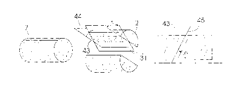
Referring now to Figure 15, penetrative lineations (43) require both a theta
(0) angle
and an alpha (a) angle to be measured relative to the geographic vertical
plane (31)
or, in other words, the reference line (7). For penetrative lineations, such
as those
formed by aligned needle-shaped minerals in the rock, the portion of the core
with
the most expression of the lineation and that with the least expression are
identified.
First the lineation plane (44) is found. This is done by marking a point on
the image
(1) where a lineation appears as a round dot on the surface of the core (2).
The
lineation plane (44) is defined as the plane bisecting the core (2) in which
the linear
feature (43) has its maximum extension. It is usual to mark the intersection
of this
plane with the core circumference down the length of the core sample (2) and
then
measure 0.
CA 02679415 2013-02-04
This is followed by a determination of a, being the pitch of the lineation
(43) in the
lineation plane (44). The core sample (2) must then be manually inspected to
locate
a lineation (43) that forms a line (45) along the surface of the core (2). A
line parallel
to the markings showing the most expression is generated and a dot marks a
point
5 at the position where the least expression is identified (not shown). The
lineation line
(45) is reproduced on the image using the cursor. This can be done by clicking
on
two points that would be located on the identified lineation line (45).
Once these marks are recorded, the software program calculates the 0 and a
angles
10 from this information of the lineations.
In practice, an ellipse or trace (37) can be generated on the core image to
calculate
0 and a angles for penetrative lineations. The nose of the ellipse is placed
at the
point of least expression and the side of the ellipse overlies the area of
most
15 expression. This is simply done using the cursor.
Referring to Figure 16, calculation of a, i3 and 0 angles can also be made by
the
software program through unfolding the cylinder of the core (2) as shown. The
elliptical structural plane (29) will be represented as a sine curve. This can
be
20 plotted by the software based on the structural features visible and
recordable from
the image (1). By marking three or more points on the ellipse (29) using the
cursor,
the graph can be plotted. In Figure 16, the core (2) as it is seen in the
image (1) is
shown on the left with a graph indicating the angles on the right.
25 The software program will provide all the necessary fields for logging
data, either
manually or through computation. Prompts and menus made available as part of
the
program will facilitate the logging process.
Incremental processing of depth and then structure detail is carried out for
each run
up to the next core block (10). This emphasizes how much core (2) has been
recovered, which is translated to a depth registration. In the process of
CA 02679415 2009-08-28
WO 2007/102129
PCT/1B2007/050764
26
core logging, the software thus enables recording of the measurement of depth
along the core samples (2) from the borehole collar.
Also taken into account is that the "stick up" at the top of the drill string
may vary
for each of the runs. Normally, a constant stick up is subtracted from total
length
of drill string to get length of the rod string in the ground (i.e. borehole
depth).
However, each time the stick up is different it affects the run length. The
driller
provides a sheet with the "stick up" values for each run as well as recording
the
length of the inner tube of the core barrel. If more core is recorded as being
recovered than the length of the inner tube, it indicates an error in
measurement. If the driller's advance is longer than the inner tube length
then
core must either have been ground away or the borehole intersected a cavity
resulting in core loss.
The usual incremental recording of data by a driller determines that any
mistake
is passed on throughout the results that follow. The logging software corrects
these errors and ties up the runs that are being logged with the driller's
runs
(from the sheet).
The software thus provides for the necessary length (or depth) and angle
measurements. Point logs including this data are recorded for each structure.
The rest of the logging is done in "Interval Logs" where details of what can
be
seen on each section of core are set out. Clicking on a contact between two
different lithologies intersected in the core, where the contact intersects
the
reference line, places a marker on the reference line in the image. Right
clicking then displays a pop-up menu in which there is a choice to "Add
Lithology". Clicking on this choice brings up an editable Lithological
Dictionary
where the rock type preceding the marker can be chosen and colour and text
coded tags are then automatically placed on each segment of the interval so
marked.
While what has been set out deals mainly with the measurement aspects of
logging, the software will also specifically provide descriptive aspects of
logging.
These can be divided into core interval classification and structure
classification.
CA 02679415 2009-08-28
WO 2007/102129
PCT/1B2007/050764
27
For the interval classification, we have already mentioned recording
estimations
of missing section but this also includes recording physical characteristics,
such
as whether the rock constitutes solid or rubble/matrix, as well as details of
lithology, weathering and texture etc. The structure classification will
include
details of planar and linear features. The planar features could be open or
healed fractures, bedding or cleavage amongst others. The linear features can
be recorded as penetrative or non-penetrative, slickensides, mineral
lineations
etc.
The description of core (2) is normally quite subjective, depending on the
preferences of a particular geologist. In this regard, the software will be
flexible
and easily customized to whatever the user prefers. The provision of graphic
logs as part of the software for recording these descriptive details will be
subject
to customization depending on a particular person's logging preferences. That
means that the presence and content of pop-up windows, drop down menus
and other such features useful for description (see below) can be designed to
the specific requirements of a user.
After the core losses or gains have been estimated for each run of core, the
software program is enabled to automatically compute the true depths along the
borehole path of all features logged in the core, eliminating the errors
induced
by core gain or loss that are normally not taken into account when logging the
core manually. This is essential for meaningful comparison of the core logs
with
data derived from borehole geophysics where a variety of sondes are lowered
into the borehole to measure various physical properties directly from the
rock
at depth. Once the core has been depth registered and a survey of the
borehole path has been loaded, the program is further enabled to compute the
true vertical depth and geographic coordinates of every feature logged.
Co-ordinates for down-hole features are calculated and plotted in a desired
format. While the data will generally be presented in table form as it is
logged, in
the case oriented core, it is also simultaneously plotted on a Stereonet
display.
This representation of three-dimensional data is well known to those skilled
in
the art and will not be described in any detail. The software will furthermore
CA 02679415 2013-02-04
=
28
provide for automated three-dimensional ground modeling based on the data that
is
logged from oriented core.
Once the borehole survey information is loaded into the program all alpha and
beta
angles are rotated, according to the trend and plunge of the core axis at the
depth
from which each structure was measured, to derive true dip and dip direction.
The
poles to these planes are then displayed and contoured on an Equal Area
Stereonet
plot (48), which can be seen in Figure 18.
The three-dimensional ground modeling will normally follow confirmation and
refining of the "measured whilst drilling borehole survey" results with data
from an
"independent borehole survey". Once the data from non-oriented core is
verified in
this manner, there will be limited ground interpretation and correlation
provided
which is also of value.
The software provides fields for equivalent "measured whilst drilling borehole
survey" results and "independent borehole survey" results to be independently
loaded and interchangeably used for calculation and display. The structural
measurements will include "raw" data displayed simultaneously on an Equal
Angle
Stereonet, as mentioned, and "rotated" data displayed simultaneously on an
Equal
Area Stereonet. The raw data is measured relative to the core axis only while
the
rotated data are in situ values relative to the borehole itself.
The software enables dry density values to be computed for segments of core
(2)
that have a clean planar feature picked at either end. The volume of the stick
or
segment can be determined and all that is required for the density calculation
is to
enter an accurate weight of that portion of the core sample. The software
program
will also be enabled for automatic calculation of, amongst others, Rock
Quality
Designation (RQD) and Rock Mass Index (RMI). Information will be displayed as
geotechnical logs and "tadpole" plots for both plane and lineation data.
CA 02679415 2009-08-28
WO 2007/102129
PCT/1B2007/050764
29
As already suggested, the method and software enable the recording of details
regarding the rock core quality. A "core quality index" derived from the core
loss
and recovery parameters will be presented with the other data.
It will be appreciated that the system removes much of the uncertainty from
geotechnical core logging. All depth and angular measurement is done through
precise image processing that delivers a fully auditable and permanent record.
Such reliably marked up images (1) allow the geologist to fully concentrate on
examining the core (2) and make detailed and accurate description of all the
structures identified. Referring to Figure 17, the logging software program
provides a pop-up window form (46) for such description. This window is
activated by right clicking on the selected structure. The form has several
drop-
down menus (47) providing a variety of choices from classifying the structure
(as bedding, cleavage, joint, foliation etc.), to describing it in detail (as
rough or
smooth, planar or curved etc.). Provision is also made for recording the
mineralogy of any infill as well as comment on any out of the ordinary
observations.
In the case of non-oriented core, joint separation for planar features and
attitude
to core axis for linear features will be recorded. Where the core has been
oriented, the dip and dip direction of planar features and the plunge and
plunge
direction of linear features are recorded. All the structural data is
therefore
recorded in either the Oriented or Un-oriented structural log, depending on
whether the core segments (2) have an oriented reference line (26) or not.
Both
of these logs, together with the driller's log, depth and density logs can be
exported to a Microsoft Excel program (or equivalent) for importing into other
programs for further analysis.
However, given the borehole survey data the software program automatically
rotates the oriented data to display the results as a contoured stereogram
(48).
Small circles can then be drawn on the Stereonet (48) to select clusters of
data
which allows for in-depth analysis of the various physical features that make
up
the cluster. Data for plotting on the Stereonet (48) can also be selected by
depth or by structure type or both and synoptic reports generated. These
CA 02679415 2009-08-28
WO 2007/102129
PCT/1B2007/050764
reports will include: Depth registration logs detailing core loss/gain per run
and true
depth; True vertical depth (TVD) logs of all structural readings and
lithological contact
intersections; Workbooks for each borehole detailing the following on separate
spreadsheets: (i) Raw manually logged structural data provided. (ii) Data
filtered and
5 discarded for analysis ¨ with reasons. (iii) Confirmed data. (iv)
Rejected data ¨ with
reasons. (v) Digitally re-measured data for rejected structures (vi) Logged
fracture
frequency along the core (vii) Percent confidence in the raw data provided and
in the
final re-processed data. (viii) Stereoplots for total core, by selected depth
intervals and
by lithologies intersected in the borehole.
The software programs described comprise (i) image processing and (ii) core
logging applications. The image processing software can be provided as a
separate package which is retained by the proprietor or service provider. The
logging package, including the various aids for core preparation, is then made
available to users under contract.
The image processing can be carried out by the proprietor and charged on a
per meter basis. This work will normally be done off-site, using, for example,
secure email to transmit the images with a rapid turn-around time limit. On-
site
training for operating the logging package will be charged on a daily basis.
What is set out with regard to the software described above, explains to some
extent the requirements for operation and for the calculations. In another
version of the image processing software, the elevated blue (20) and green
(19)
lines on the frame are detected by the program. The image (1) is processed and
corrected as mentioned above automatically. A suitably taken photograph (1) of
a core tray (6) in an appropriately marked frame (11) is all that is required.
Furthermore, in this version, the orientation lines (7) will be drawn onto the
core
samples (2) with a marker that is recognized by what may either be the image
processing or logging software. Automatic depth readings are in turn generated
for the portions of solid core (2). The core blocks (10) will also be
recognized
and cross referenced with the depth readings provided with the driller's log.
CA 02679415 2009-08-28
WO 2007/102129
PCT/1B2007/050764
31
In addition to this, a core tray with ridges visible between the core samples
(2)
will be used. The ridges will also be recognized by the software to provide a
true
diameter reading and to also generate a central reference line (26). The
angular
difference between this line (26) and the recognized orientation line (7) will
be
calculated automatically for corrections when providing alpha and beta angle
measurements for structures.
It follows that planar structures, both open and healed, can also either be
manually traced with a suitable marker that is detected by the software for
automatic alpha and beta angle calculations, or the software can be adapted
and trained to recognize such structures without necessarily marking them. The
same applies to markings that will enable theta angle calculations for
lineations.
While these and other readings or data recordings may be automated, the
option of making corrections is always available. Information that requires
judgment and estimation will be introduced in the ordinary interactive manner
by
a suitably skilled person. Importantly, the image (1) of the core is always
available and inaccurate automatic tracers or markers generated as described
can be scrutinized and corrected.
It will be appreciated that the inclusion of a measurement scale (C) in the
image
is not essential. A particular magnification and fixed distance between the
camera and core will allow calibration ¨ the average core diameter is normally
known.
The photograph also provides historical detail of the core as it was when it
came out of the core barrel. Any subsequent damage can therefore be
attributed to mechanical breakage that may have happened in transportation to
the core shed or storage.
For optimum results best practice calls for a comprehensive logging technique
that keeps pace with the drilling rate and immediately presents the results
for
analysis and evaluation. The invention provides a means of achieving this and
presents a saving in the time taken for proper core logging. It further
provides
CA 02679415 2009-08-28
WO 2007/102129
PCT/1B2007/050764
32
an accurate visual record of the core, which can be revisited at a later stage
for
comparison to the logged data or for any other reason. The importation of
manually recorded data which can then be fully audited for validity is another
advantageous feature.
The software will be provided on a suitable computer readable medium and can
be used with any combination of hardware suited for the purpose set out above.
In so far as hardware is concerned, it is mainly a digital camera connectable
to
a computer that is required. These components could however be integrated
into a dedicated machine.
A suitably skilled person will appreciate that a number of variations may be
made to the described embodiments or aspects described without departing
from the scope of the current invention. In particular, the collection of the
data
and computation of angles from the calibrated image are not limited to what
has
been set out in this description.
25