Note: Descriptions are shown in the official language in which they were submitted.
CA 02682010 2009-09-25
WO 2008/134599
PCT/US2008/061695
MULTI-COMPONENT MARINE ELECTROMAGNETIC
SIGNAL ACQUISITION CABLE, SYSTEM AND METHOD
FIELD
[0001] The
invention relates generally to the field of marine electromagnetic
.. geophysical surveying. More specifically, the invention relates to cables
and related
apparatus for acquiring, recording and transmitting electromagnetic signals
produced
for subsurface Earth surveying.
BACKGROUND
[0002]
Electromagnetic geophysical surveying includes "controlled source"
.. and natural source electromagnetic surveying. Controlled source
electromagnetic
surveying includes imparting an electric field or a magnetic field into the
Earth
formations, those formations being below the sea floor in marine surveys, and
measuring electric field amplitude and/or amplitude of magnetic fields by
measuring
voltage differences induced in electrodes, antennas and/or interrogating
.. magnetometers disposed at the Earth's surface, or on or above the sea
floor. The
electric and/or magnetic fields are induced in response to the electric field
and/or
magnetic field imparted into the Earth's subsurface, and inferences about the
spatial
distribution of conductivity of the Earth's subsurface are made from
recordings of the
induced electric and/or magnetic fields.
[0003] Natural source electromagnetics includes multi-components ocean
bottom receiver stations, and by taking the ratio of perpendicular field
components,
one can eliminate the need to know the natural source. Hereto, natural source
electromagnetics for marine applications has been restricted to autonomous
recording stations.
[0004] Controlled source electromagnetic surveying known in the art
includes
imparting alternating electric current into formations below the sea floor.
The
alternating current has one or more selected frequencies. Such surveying is
known
as frequency domain controlled source electromagnetic (f-CSEM) surveying. f-
CSEM surveying techniques are described, for example, in Sinha, M.C. Patel,
P.D.,
1
CA 02682010 2009-09-25
WO 2008/134599
PCT/US2008/061695
Unsworth, M.J., Owen, T.R.E., and MacCormack, M.G.R., 1990, An active source
electromagnetic sounding system for marine use, Marine Geophysical Research,
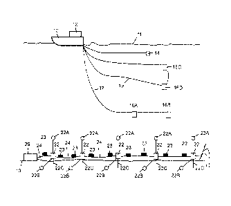
12,
29-68. Other publications which describe the physics of and the interpretation
of
electromagnetic subsurface surveying include: Edwards, R.N., Law, L.K.,
Wolfgram,
P.A., Nobes, D.C., Bone, M.N., Trigg, D.F., and DeLaurier, J.M., 1985, First
results
of the MOSES experiment: Sea sediment conductivity and thickness
determination,
Bute Inlet, British Columbia, by maanetometric offshore electrical sounding:
Geophysics 50, No. 1, 153-160; Edwards, R.N., 1997, On the resource evaluation
of
marine gas hydrate deposits using the sea-floor transient electric dipole-
dipole
method: Geophysics, 62, No. 1, 63-74; Chave, A.D., Constable, S.C. and
Edwards,
R.N., 1991, Electrical exploration methods for the seafloor: Investigation in
geophysics No 3, Electromagnetic methods in applied geophysics, vol. 2,
application, part B, 931-966; and Cheesman, S.J., Edwards, R.N., and Chave,
A.D.,
1987, On the theory of sea-floor conductivity mapping using transient
electromagnetic systems: Geophysics, 52, No. 2, 204-217.
[0005]
Other publications of interest in the technical field of electromagnetic
surveying include Edwards, N., 2005, Marine controlled source
electromagnetics:
Principles, Methodologies, Future commercial applications: Surveys in
Geophysics,
No. 26, 675-700; Constable, S., 2006, Marine electromagnetic methods - A new
tool
for offshore exploration: The Leading Edge v. 25, No. 4, p. 438-
444.;Christensen, N.
B. and Dodds, K., 2007, 1D inversion and resolution analysis of marine CSEM
data,
Geophysics 72, WA27;; Chen, J., Hoversten, G. M., Vasco, D., Rubin, Y., and
Hou,
Z., 2007, A Bayesian model for gas saturation estimation using marine seismic
AVA
and CSEM data, Geophysics 72, WA85; Constable, S. and Srnka, L. J., 2007, An
introduction to marine controlled-source electromagnetic methods for
hydrocarbon
exploration, Geophysics 72, WA3; Evans, R. L., 2007, Using CSEM techniques to
map the shallow section of seafloor: From the coastline to the edges of the
continental slope, Geophysics 72, WA105; Darnet, M., Choo, M. C. K., Plessix,
R.
D., Rosenquist, M. L., Yip-Cheong, K., Sims, E., and Voon, J. W. K., 2007,
Detecting
hydrocarbon reservoirs from CSEM data in complex settings: Application to
deepwater Sabah, Malaysia, Geophysics 72, WA97; Gribenko, A. and Zhdanov, M.,
2007, Rigorous 3D inversion of marine CSEM data based on the integral equation
method, Geophysics 72, WA73; Li, Y. and Key, K. 2007, 2D marine controlled-
2
CA 02682010 2009-09-25
WO 2008/134599
PCT/US2008/061695
source electromagnetic modeling: Part 1 ¨ An adaptive finite-element
algorithm,
Geophysics 72, WA51; Li, Y. and Constable, S., 2007, 2D marine controlled-
source
electromagnetic modeling: Part 2 ¨ The effect of bathymetry, Geophysics 72,
WA63;
Scholl, C. and Edwards, R. N., 2007, Marine downhole to seafloor dipole-dipole
electromagnetic methods and the resolution of resistive targets, Geophysics
72,
WA39; Tompkins, M. J. and Srnka, L. J., 2007, Marine controlled-source
electromagnetic methods ¨ Introduction, Geophysics 72, WA1; Um, E. S. and
Alumbaugh, D. L., 2007, On the physics of the marine controlled-source
electromagnetic method, Geophysics 72, WA13; Dell'Aversana, P., 2007,
Improving
interpretation of CSEM in shallow water, The Leading Edge 26, 332; Hokstad,
K.,
and Rosten, T., 2007, On the relationships between depth migration of
controlled-
source electromagnetic and seismic data, The Leading Edge 26, 342; Johansen,
S.
E., Wicklund, T. A. and Amundssen, H. E. F., 2007, Interpretation example of
marine
CSEM data, The Leading Edge 26, 348; and MacGregor, L., Barker, N., Overton,
A.,
Moody, S., and Bodecott, D., 2007, Derisking exploration prospects using
integrated
seismic and electromagnetic data ¨ a Falkland Islands case study, The Leading
Edge 26, 356.
[0006]
Following are described several patent publications which describe
various aspects of electromagnetic subsurface Earth surveying. U.S. Patent No.
5,770,945 issued to Constable describes a magnetotelluric (MT) system for sea
floor
petroleum exploration. The disclosed system includes a first waterproof
pressure
case containing a processor, AC-coupled magnetic field post-amplifiers and
electric
field amplifiers, a second waterproof pressure case containing an acoustic
navigation/release system, four silver-silver chloride electrodes mounted on
booms
and at least two magnetic induction coil sensors. These elements are mounted
together on a plastic and aluminum frame along with flotation devices and an
anchor
for deployment to the sea floor. The acoustic navigation/release system serves
to
locate the measurement system by responding to acoustic "pings" generated by a
ship-board unit, and receives a release command which initiates detachment
from
the anchor so that the buoyant package floats to the surface for recovery. The
electrodes used to detect the electric field are configured as grounded dipole
antennas. Booms by which the electrodes are mounted onto a frame are
positioned
in an X-shaped configuration to create two orthogonal dipoles. The two
orthogonal
3
CA 02682010 2009-09-25
WO 2008/134599
PCT/US2008/061695
dipoles are used to measure the complete vector electric field. The magnetic
field
sensors are multi-turn, Mu-metal core wire coils which detect magnetic fields
within
the frequency range typically used for land-based MT surveys. The magnetic
field
coils are encased in waterproof pressure cases and are connected to the logger
package by high pressure waterproof cables. The logger unit includes
amplifiers for
amplifying the signals received from the various sensors, which signals are
then
provided to the processor which controls timing, logging, storing and power
switching
operations. Temporary and mass storage is provided within and/or peripherally
to
the processor. There is no active source in such MT methods, which rely upon
naturally occurring EM fields.
[0007]
U.S. Patent No. 6,603,313 B1 issued to Srnka discloses a method for
surface estimation of reservoir properties, in which average earth
resistivities above,
below, and horizontally adjacent to specifically located subsurface geologic
formations are first determined or estimated using geological and geophysical
data in
the vicinity of the subsurface geologic formation. Then dimensions and probing
frequency for an electromagnetic source are determined to substantially
maximize
transmitted vertical and horizontal electric currents at the subsurface
geologic
formation, using the location and the average earth resistivities.
Next, the
electromagnetic source is activated at or near the sea floor, approximately
centered
above the subsurface geologic formation and a plurality of components of
electromagnetic response is measured with a receiver array. Geometrical and
electrical parameter constraints are determined, using the geological and
geophysical data. Finally, the electromagnetic response is processed using the
geometrical and electrical parameter constraints to produce inverted vertical
and
horizontal resistivity depth images. Optionally, the inverted resistivity
depth images
may be combined with the geological and geophysical data to estimate the
reservoir
fluid and shaliness (fractional volume in the formation of clay-bearing rocks
called
"shale") properties.
[0008]
U.S. Patent No. 6,628,110 B1 issued to Eidesmo et al. discloses a
method for determining the nature of a subterranean reservoir whose
approximate
geometry and location are known. The disclosed method includes: applying a
time
varying electromagnetic field to the strata containing the reservoir;
detecting the
4
CA 02682010 2009-09-25
WO 2008/134599
PCT/US2008/061695
electromagnetic wave field response; and analyzing the effects on the
characteristics
of the detected field that have been caused by the reservoir, thereby
determining the
content of the reservoir, based on the analysis.
[0009]
U.S. Patent No. 6,541,975 B2 issued to Strack discloses a system for
generating an image of an Earth formation surrounding a borehole penetrating
the
formation. Resistivity of the formation is measured using a DC measurement,
and
conductivity and resistivity of the formations are measured with a time domain
signal
or AC measurement. Acoustic velocity of the formation is also measured. The DC
resistivity measurement, the conductivity measurement made with a time domain
electromagnetic signal, the resistivity measurement made with a time domain
electromagnetic signal and the acoustic velocity measurements are combined to
generate the image of the Earth formation.
[0010]
International Patent Application Publication No. WO 0157555 Al
discloses a system for detecting a subterranean reservoir or determining the
nature
of a subterranean reservoir whose position and geometry is known from previous
seismic surveys. An electromagnetic field is applied by a transmitter on the
seabed
and is detected by antennae also on the seabed. A refracted wave component is
sought in the wave field response, to determine the nature of any reservoir
present.
[0011]
International Patent Application Publication No. WO 03048812 Al
discloses an electromagnetic survey method for surveying an area previously
identified as potentially containing a subsea hydrocarbon reservoir. The
method
includes obtaining first and second survey data sets with an electromagnetic
source
aligned end-on and broadside relative to the same or different receivers. The
invention also relates to planning a survey using this method, and to analysis
of
survey data taken in combination so as to allow the galvanic contribution to
the
signals collected at the receiver to be contrasted with the inductive effects,
and the
effects of signal attenuation (which are highly dependent on local properties
of the
rock formation, overlying water, and air at the survey area). This is very
important to
the success of using electromagnetic surveying for identifying hydrocarbon
reserves
and distinguishing them from other classes of subsurface formations.
5
CA 02682010 2009-09-25
WO 2008/134599
PCT/US2008/061695
[0012]
U.S. Patent No. 6,842,006 B1 issued to Conti et al. discloses a sea-
floor electromagnetic measurement device for obtaining underwater
magnetotelluric
(MT) measurements of earth formations. The device includes a central structure
with arms pivotally attached thereto. The pivoting arms enable easy deployment
and
storage of the device. Electrodes and magnetometers are attached to each arm
for
measuring electric and magnetic fields respectively, the magnetometers being
distant from the central structure such that magnetic fields present therein
are not
sensed. A method for undertaking sea floor measurements includes measuring
electric fields at a distance from the structure and measuring magnetic fields
at the
same location.
[0013]
U.S. Patent Application Publication No. 2004/232917 and U.S. Patent
No. 6,914,433 Detection of subsurface resistivity contrasts with application
to
location of fluids (Wright, et al) relate to a method of mapping subsurface
resistivity
contrasts by making multichannel transient electromagnetic (MTEM) measurements
on or near the Earth's surface using at least one source, receiving means for
measuring the system response and at least one receiver for measuring the
resultant
earth response. All signals from each source-receiver pair are processed to
recover
the corresponding electromagnetic impulse response of the earth and such
impulse
responses, or any transformation of such impulse responses, are displayed to
create
a subsurface representation of resistivity contrasts. The system and method
enable
subsurface fluid deposits to be located and identified and the movement of
such
fluids to be monitored.
[0014]
U.S. Patent No. 5,467,018 issued to Rueter et al. discloses a bedrock
exploration system. The system includes transients generated as sudden changes
in a transmission stream, which are transmitted into the Earth's subsurface by
a
transmitter. The induced electric currents thus produced are measured by
several
receiver units. The measured values from the receiver units are passed to a
central
unit. The measured values obtained from the receiver units are digitized and
stored
at the measurement points, and the central unit is linked with the measurement
points by a telemetry link. By means of the telemetry link, data from the data
stores
in the receiver units can be successively passed on to the central unit.
6
CA 02682010 2009-09-25
WO 2008/134599
PCT/US2008/061695
[0015] U.S. Patent No. 5,563,913 issued to Tasci et al. discloses a
method
and apparatus used in providing resistivity measurement data of a sedimentary
subsurface. The data are used for developing and mapping an enhanced
anomalous resistivity pattern. The enhanced subsurface resistivity pattern is
associated with and an aid for finding oil and/or gas traps at various depths
down to
a basement of the sedimentary subsurface. The apparatus is disposed on a
ground
surface and includes an electric generator connected to a transmitter with a
length of
wire with grounded electrodes. When large amplitude, long period, square waves
of
current are sent from a transmission site through the transmitter and wire,
secondary
eddy currents are induced in the subsurface. The eddy currents induce magnetic
field changes in the subsurface which can be measured at the surface of the
earth
with a magnetometer or induction coil. The magnetic field changes are received
and
recorded as time varying voltages at each sounding site. Information on
resistivity
variations of the subsurface formations is deduced from the amplitude and
shape of
the measured magnetic field signals plotted as a function of time after
applying
appropriate mathematical equations. The sounding sites are arranged in a plot-
like
manner to ensure that areal contour maps and cross sections of the resistivity
variations of the subsurface formations can be prepared.
[0016] Other U.S. Patent documents that provide background
information
concerning the present invention include the following:
[0017] U.S. Patent No. 4,535,292 Transmitter for an electromagnetic
survey
system with improved power supply switching system (Ensing).
[0018] U.S. Patent No. 5,130,655 Multiple-coil magnetic field sensor
with
series-connected main coils and parallel-connected feedback coils (Conti).
[0019] U.S. Patent No. 5,877,995 Geophysical prospecting (Thompson et al.).
[0020] U.S. Pat. No. 5,955,884 Method and apparatus for measuring
transient
electromagnetic and electrical energy components propagated in an earth
formation
(Payton et al.).
7
CA 02682010 2009-09-25
WO 2008/134599
PCT/US2008/061695
[0021]
U.S. Patent No. 6,188,221 Method and apparatus for transmitting
electromagnetic waves and analyzing returns to locate underground fluid
deposits
(Van de Kop et al.).
[0022]
U.S. Patent No. 6,225,806 Electroseismic technique for measuring the
properties of rocks surrounding a borehole (Millar et al.).
[0023]
U.S. Patent No. 6,339,333 Dynamic electromagnetic methods for direct
prospecting for oil (Kuo).
[0024]
U.S. Patent No. 6,628,119 Method and apparatus for determining the
content of subterranean reservoirs (Eidesmo, et al).
[0025] U.S. Patent No. 6,664,788 Nonlinear electroseismic exploration
(Scott
C. Hornbostel, et al).
[0026]
U.S. Patent No. 6,696,839 Electromagnetic methods and apparatus for
determining the content of subterranean reservoirs (Svein Ellingsrud et al).
[0027]
U.S. Patent No. 6,717,411 Electromagnetic method and apparatus for
determining the nature of subterranean reservoirs using refracted
electromagnetic
waves (Ellingsrud, et al).
[0028]
U.S. Patent No. 6,859,038 Method and apparatus for determining the
nature of subterranean reservoirs using refracted electromagnetic waves (Svein
Ellingsrud, et al).
[0029] U.S. Patent No. 6,864,684 Electromagnetic methods and apparatus for
determining the content of subterranean reservoirs (Ellingsrud, et al).
[0030]
U.S. Patent No. 6,864,684 Electromagnetic methods and apparatus for
determining the content of subterranean reservoirs (Ellingsrud, et al).
[0031]
U.S. Patent No. 7,023,213 Subsurface conductivity imaging systems
and methods (Edward Nichols).
[0032]
U.S. Patent No. 7,038,456 Method and apparatus for determining the
nature of subterranean reservoirs (Ellingsrud, et al).
8
CA 02682010 2009-09-25
WO 2008/134599
PCT/US2008/061695
[0033]
U.S. Patent No. 7,042,801 System for geophysical prospecting using
induce electrokinetic effect (Andrey Berg).
[0034]
U.S. Patent No. 7,126,338 Electromagnetic surveying for hydrocarbon
reservoirs (MacGregor, Lucy et al.).
[0035] U.S.
Patent No. 7,141,968 Integrated sensor system for measuring
electric and/or magnetic field vector components (Hibbs, et al).
[0036] U.
S. Patent No. 7,141,987 Sensor system for measurement of one or
more vector components of an electric field (Hibbs, et al).
[0037]
U.S. Patent No. 7,145,341 Method and apparatus for recovering
hydrocarbons from subterranean reservoirs (Ellingsrud, et al).
[0038]
U.S. Patent No. 7,191,063 Electromagnetic surveying for hydrocarbon
reservoirs (Tompkins).
[0039]
U.S. Pat. Appl. Pub. No. 2006/0091889 Method and apparatus for
determining the nature of subterranean reservoirs (Ellingsrud, Svein et al)
Application No.: 11/301,010 filed on Dec 12, 2005, granted as U.S. Patent No.
7,202,669 on April 10, 2007.
[0040]
U.S. Pat. Appl. Pub. No. 2006/0129322 Electromagnetic surveying for
hydrocarbon reservoirs (MacGregor, Lucy et al)
[0041]
U.S. Pat. Appl. Pub. No. 2006/0132137 Electromagnetic surveying for
hydrocarbon reservoirs (MacGregor, Lucy et al).
[0042]
U.S. Pat. Appl. Pub. No. 2006/0197532 Method and apparatus for
determining the nature of submarine reservoirs (Eidesmo, Terje et al).
[0043]
U.S. Pat. Appl. Pub. No. 2007/0021916 Electromagnetic surveying for
hydrocarbon reservoirs (MacGregor, Lucy et al).
[0044] 41.
U.S. Pat. Appl. Pub. No. 2007/0075708, ELECTROMAGNETIC
SURVEY SYSTEM WITH MULTIPLE SOURCES (Reddig, Ransom et al).
9
CA 02682010 2009-09-25
WO 2008/134599
PCT/US2008/061695
[0045] A
typical f-CSEM marine survey can be described as follows. A
recording vessel includes cables which connect to electrodes disposed near the
sea
floor. An electric power source on the vessel charges the electrodes such that
a
selected magnitude of alternating current, of selected frequency or
frequencies,
flows through the sea floor and into the Earth formations below the sea floor.
At a
selected distance ("offset") from the source electrodes, receiver electrodes
are
disposed on the sea floor and are coupled to a voltage measuring circuit,
which may
be disposed on the vessel or a different vessel. The voltages imparted into
the
receiver electrodes are then analyzed to infer the structure and electrical
properties
of the Earth formations in the subsurface.
[0046]
Another technique for electromagnetic surveying of subsurface Earth
formations known in the art is transient controlled source electromagnetic
surveying
(t-CSEM). In t-CSEM, electric current is imparted into the Earth at the
Earth's
surface (or sea floor), in a manner similar to f-CSEM. The electric current
may be
direct current (DC). At a selected time, the electric current is switched off,
switched
on, or has its polarity changed, and induced voltages and/or magnetic fields
are
measured, typically with respect to time over a selected time interval, at the
Earth's
surface or water surface. Alternative switching strategies are possible; as
will be
explained in more detail below. Structure of the subsurface is inferred by the
time
distribution of the induced voltages and/or magnetic fields. t-CSEM techniques
are
described, for example, in Strack, K.-M., 1992, Exploration with deep
transient
electromagnetics, Elsevier, 373 pp. (reprinted 1999).
SUMMARY
[0047] A
marine electromagnetic sensor cable according to one aspect of the
invention includes a plurality of sensor modules disposed at spaced apart
locations
along a cable. Each module includes at least one magnetic field sensor and at
least
one pair of electrodes associated with the module. The electrodes are arranged
to
measure electric field in a direction along the direction of the cable. The
cable is
arranged to form a closed pattern.
[0048] A marine electromagnetic surveying system according to another
aspect of the invention includes a vessel towing at least one electromagnetic
CA 02682010 2009-09-25
WO 2008/134599
PCT/US2008/061695
antenna in a body of water. A controllable source of electric current is
disposed on
the vessel. The system includes a plurality of sensor modules disposed at
spaced
apart locations along a cable. Each module includes at least one magnetic
field
sensor and at least one pair of electrodes associated therewith. The
electrodes are
arranged to measure electric field in a direction along the direction of the
cable. The
cable is arranged to form a closed pattern. The system includes means for
recording
signals generated by the electrodes and magnetic field sensors in response to
electromagnetic energy imparted into the Earth's subsurface by passing
electric
current through the at least one antenna.
[0049] Another aspect of the invention is a marine electromagnetic sensor
cable including a plurality of sensor modules disposed at spaced apart
locations
along a cable. Each module includes at least one pair of electrodes associated
therewith. The electrodes are arranged to measure electric field in a
direction along
the direction of the cable. A plurality of spaced apart magnetic field sensors
is
associated with each module and arranged to enable determining an electric
field
amplitude in a direction transverse to the direction of the cable from
magnetic field
gradient.
[0050] A
marine electromagnetic surveying system according to another
aspect of the invention includes a vessel towing at least one electromagnetic
antenna in a body of water. A controllable source of electric current is
disposed on
the vessel. The system includes a plurality of sensor modules disposed at
spaced
apart locations along a cable. The sensor cable including a plurality of
sensor
modules disposed at spaced apart locations along a cable. Each module includes
at
least one pair of electrodes associated therewith. The electrodes are arranged
to
measure electric field in a direction along the direction of the cable. A
plurality of
spaced apart magnetic field sensors is associated with each module and
arranged to
enable determining an electric field amplitude in a direction transverse to
the
direction of the cable from magnetic field gradient.
[0051] A
method for measuring magnetotelluric response of the Earth's
subsurface according to another aspect of the invention includes measuring
transient
controlled source electromagnetic response of the Earth's subsurface below the
bottom of a body of water over a plurality of actuations of an electromagnetic
11
CA 02682010 2012-12-05
51099-8
transmitter. The transient response measurements are stacked and the stacked
transient response is subtracted from measurements of total electromagnetic
Earth
response over a time period including the plurality of transient response
measurements to generate the magnetotelluric response.
[0052] A method for determining a component of electric field response to a
time varYing electromagnetic field induced in the Earth's subsurface according
to
another aspect of the invention includes measuring magnetic field gradient in
at least
two orthogonal directions in response to the induced electromagnetic field and
determining an electric field response in a direction normal to the magnetic
field
gradient measurements.
[0053] Another aspect of the invention is a method for determining a
component of electric field response of the Earth's subsurface to a time
varying
electromagnetic field induced in the Earth's subsurface. A method according to
this
aspect of the invention includes measuring electric field response along a
substantially closed pattern on at least one of the Earth's surface and the
bottom of a
body of water and determining an electric field response in a direction normal
to the
measured electric field response using electric field response measurements
made
at opposed positions along the closed pattern.
12
CA 02682010 2014-03-19
51099-8
[0054] According to one aspect of the present invention, there is
provided a
marine electromagnetic sensor cable, comprising: a plurality of sensor modules
disposed at spaced apart locations along a cable, each module including at
least one
pair of electrodes associated therewith, the electrodes arranged on opposed
sides of
each module along the cable to measure electric field; wherein the cable is
arranged
to form a closed pattern; and wherein each module further comprises at least
one
laterally extending sensor arm affixed to the module, the at least one sensor
arm
including at least one electrode thereon.
[0054a] According to another aspect of the present invention, there is
provided
a marine electromagnetic surveying system, comprising: a vessel towing at
least one
electromagnetic antenna in a body of water; a controllable source of electric
current
disposed on the vessel; a plurality of sensor modules disposed at spaced apart
locations along a cable, each module including at least one pair of electrodes
associated therewith, the electrodes arranged on opposed sides of each module
along the cable to measure electric field, wherein the cable is arranged to
form a
closed pattern, and wherein each module further comprises at least one
laterally
extending sensor arm affixed to the module, the at least one sensor arm
including at
least one electrode thereon; and means for recording signals generated by the
electrodes and magnetic field sensors in response to electromagnetic energy
imparted into the Earth's subsurface by passing electric current through the
at least
one antenna.
[0054b] According to still another aspect of the present invention,
there is
provided a marine electromagnetic sensor cable, comprising: a plurality of
sensor
modules disposed at spaced apart locations along a cable, each module
including at
least one pair of electrodes associated therewith, the electrodes arranged on
opposed sides of each module along the cable to measure electric field; and a
plurality of spaced apart magnetic field sensors associated with each module
and
arranged to enable determining an electric field amplitude in a direction
transverse to
the direction of the cable from magnetic field gradient.
12a
CA 02682010 2014-03-19
51099-8
[0054c] According to yet another aspect of the present invention,
there is
provided a marine electromagnetic surveying system, comprising: a vessel
towing at
least one electromagnetic antenna in a body of water; a controllable source of
electric
current disposed on the vessel; a plurality of sensor modules disposed at
spaced
apart locations along a cable, each module including at least one pair of
electrodes
associated therewith, the electrodes arranged on opposed sides of each module
along the cable to measure electric field; and a plurality of spaced apart
magnetic
field sensors associated with each module and arranged to enable determining
an
electric field amplitude in a direction transverse to the direction of the
cable from
magnetic field gradient.
BRIEF DESCRIPTION OF THE DRAWINGS
[0055] FIG. 1 shows a marine EM acquisition system that may include
acquisition modules according to various aspects of the invention.
[0056] FIG. 2 shows one example of an acquisition module that may be
used
with the system shown in FIG. 1.
[0057] FIG. 3 shows another example of an acquisition module.
[0058] FIG. 4 shows another example of an acquisition system.
12b
CA 02682010 2009-09-25
WO 2008/134599
PCT/US2008/061695
[0059] FIG. 5 shows inducing magnetic fields in the Earth's
subsurface.
DETAILED DESCRIPTION
[0060] One example of a marine electromagnetic (EM) survey
acquisition
system is shown schematically in FIG. 1. The system may include a survey
vessel
that moves along the surface of a body of water 11 such as a lake or the
ocean.
The survey vessel 10 includes thereon certain equipment, shown generally at 12
and
referred to for convenience as a "recording system." The recording system 12
may
include (none of the following shown separately for clarity of the
illustration)
10 navigation devices, source actuation and control equipment, and devices
for
recording and processing measurements made by various sensors in the
acquisition
system. The vessel 10 may tow a seismic energy source 14 such as an air gun or
an array of such air guns, a vertical electric dipole "source" antenna 19
including
vertically spaced apart electrodes 16C, 16D and a horizontal electric dipole
"source"
antenna 17, which may include horizontally spaced apart electrodes 16A, 16B.
The
vertical electrodes 16C, 16D are typically energized by current flowing
through one
of the lines going from either electrode 16C or 16D to the survey vessel 10.
The
other line may be electrically inactive and only used to keep the vertical
dipole
antenna in is preferred shape. The electrodes on the source antennas 17, 19
may
be referred to as "source electrodes" for convenience. The recording system 12
may
include a controllable power supply (not shown separately) to energize the
source
electrodes for the purpose of inducing electromagnetic fields in the
subsurface below
the water bottom 13.
[0061] In the present example the source electrodes 16A, 16B and 16C,
16D,
respectively on each antenna 17, 19, can be spaced apart about 50 meters, and
can
be energized by the power supply (not shown) such that about 1000 Amperes of
current flows through the electrodes. This is an equivalent source moment to
that
generated in typical electromagnetic survey practice known in the art using a
100
meter long transmitter dipole, and using 500 Amperes current. In either case
the
source moment can be about 5X10⁴ Ampere-meters. The source moment used in
any particular implementation is not intended to limit the scope of this
invention.
13
CA 02682010 2009-09-25
WO 2008/134599
PCT/US2008/061695
[0062] If
the system is configured to record transient EM signals, the electric
current used to energize the source electrodes can be direct current (DC)
switched
off at a particular time or at particular times. Such switching time may be
conveniently correlated to a signal recording time index equal to zero. It
should be
understood, however, that switching DC off is only one implementation of
electric
current switching that is operable to induce transient electromagnetic effects
in the
Earth's subsurface. In other examples, the electric current (DC) may be
switched
on, may be switched from one polarity to the other (bipolar switching), or may
be
switched in a pseudo-random binary sequence (PRBS) or any hybrid derivative of
such switching sequences. See, for example, Duncan, P.M., Hwang, A., Edwards,
R.N., Bailey, R.C., and Garland, G.D., 1980, The development and applications
of a
wide band electromagnetic sounding system using pseudo-noise source,
Geophysics, 45, 1276-1296 for a description of PBRS switching. The system may
also be configured to record "frequency domain" signals in conjunction with or
alternatively to recording transient signals. The power supply (not shown) may
in
such instances generate a continuous alternating current having one or more
selected component frequencies to perform such frequency domain
electromagnetic
surveying.
[0063] The
recording system 12 may include equipment (the source controller)
that may actuate the seismic source 14 at selected times and may include
devices
that record, or accept recordings for processing, from seismic sensors
(explained
below with reference to FIG. 2) that may be disposed in a sensor cable 24 or
elsewhere in the acquisition system.
[0064] In
the present example, the sensor cable 24 is shown disposed on the
water bottom 13 for making measurements corresponding to Earth formations
below
the water bottom 13. The sensor cable 24 may include thereon a plurality of
longitudinally spaced apart sensor modules 22. Examples of components in each
sensor module 22 will be further explained below with reference to FIGS 2 and.
3.
Each sensor module 22 may have inserted into an upper side thereof a
substantially
vertically extending sensor arm 22A. Details of one example of the vertically
extending sensor arm 22A will be explained below with reference to FIG. 3.
Preferably the vertically extending sensor arm 22A includes therein or thereon
some
14
CA 02682010 2009-09-25
WO 2008/134599
PCT/US2008/061695
type of buoyancy device or structure (not shown separately) to assist in
keeping the
sensor arm 22A in a substantially vertical orientation with respect to
gravity. Each
sensor module 22 may include extending from its lower side a spike 22C as
described, for example, in Scholl, C. and Edwards, N., 2007, Marine downhole
to
seafloor dipole-dipole electromagnetic methods and the resolution of resistive
targets, Geophysics, 72, WA39, for penetrating the sediments that exist on the
water
bottom 13 to a selected depth therein. Disposed about the exterior of portions
of the
sensor cable 24 adjacent each longitudinal end of each sensor module 22 may be
galvanic electrodes 23 which are used to measure voltages related to certain
components of electric field response to induced electromagnetic fields in the
subsurface. In the present example, laterally extending sensing arms 22B may
be
disposed from one or both the sides of each sensor module 22. Such sensing
arms
22B will be explained in more detail with reference to FIG. 3. The sensor
cable 24
may in some implementations be disposed on the water bottom 13 in a closed
pattern that will be further explained with reference to FIG. 4.
[0065]
Signals acquired by various sensing devices associated with each
module 22 and the cable 24 may be transmitted to and stored in a recoding node
26.
Such transmission may be made by including in the cable 24 one or more
electrical
and/or optical conductors (not shown) to carry electrical power and/or data
signals.
The recording node 26 may be disposed on the water bottom 13 as shown on
disposed in a buoy (not shown) at the discretion of the system designer. The
recording node 26 may include any form of data storage device, for example a
terabyte-sized hard drive or solid state memory. If disposed on the water
bottom 13
as shown in FIG. 1, the recording node 26 may be retrieved from the water
bottom
13 by the vessel 10 to interrogate the storage device (not shown), or the
storage
device (not shown) may be accessed for interrogation by connecting a data
transfer
cable (not shown) to a suitable connector or port (not shown) on the recording
node
26. The manner of data storage and transfer with respect to the node 26 may be
according to well known art and are not intended to limit the scope of this
invention.
[0066] One example of the sensor module 22 is shown in cut away view in
FIG. 2. The sensor module 22 may include a sealed, pressure resistant housing
28
affixed to the cable 24 at a selected position along the cable 24. The housing
28
CA 02682010 2009-09-25
WO 2008/134599
PCT/US2008/061695
may be affixed to the cable 24 by splicing within the cable, by molding the
housing
28 thereon or by using water tight, pressure resistant electrical and
mechanical
connectors on each of the cable 24 and housing 28, such as a connector shown
in
U.S. Patent No. 7,113,448 issued to Scott.
[0067] The interior of the housing 28 may define a pressure sealed
compartment that may include some or all of the components described below.
Sensing elements in the module 22 may include a three-axis magnetometer M that
includes horizontal Mx, My and vertical Mz component magnetic field sensors. A
three component seismic particle motion sensor G may also be disposed in the
housing 28. The seismic particle motion sensor G may include three mutually
orthogonal motion sensors Gx, Gy, Gz such as geophones or accelerometers. The
seismic sensor G detects particle motion components of a seismic wavefield
induced
by the seismic source (14 in FIG. 1). The sensor module 22 may also include a
hydrophone 30 in pressure communication with the water (11 in FIG. 1) for
detecting
the pressure component of the seismic wavefield induced by the seismic source
(14
in FIG. 1). The sensor module 22 may also include a gravity sensor GR within
the
housing 28. The sensor module 22 may include voltage measuring circuits 39, 40
to
measure voltages impressed across pairs of galvanic electrodes (23 in FIG. 1)
disposed on opposed sides of the module 22 along the cable 24. In the present
example, the electrode pairs may also include an electrode disposed along or
at the
end of each of the vertical sensing arm 22A (the electrode shown at 23B) and
the
spike 22C (the electrode shown at 23A). The vertical sensing arm 22A may be
coupled to the housing 28 in a manner as will be explained below with
reference to
FIG. 3.
[0068] Signals generated by each of the sensing devices described above
may enter a multiplexer 32. Output of the multiplexer 32 may be conducted
through
a preamplifier 34. The preamplifier may be coupled to the input of an analog
to
digital converter (ADC) 36, which converts the analog voltages from the
preamplifier
34 into digital words for storing and processing by a central processor 38,
which may
be any microprocessor based controller and associated data buffering and/or
storage device known in the art. Data represented by digital words may be
formatted for signal telemetry along the cable 24 to the recording node (26 in
FIG. 1)
16
CA 02682010 2009-09-25
WO 2008/134599
PCT/US2008/061695
for later retrieval and processing, such as by or in the recording system (12
in FIG.
1). The sensor module 22 may also include one or more high frequency
magnetometers MH in signal communication with the multiplexer 32 and the
components coupled to the output thereof.
[0069] The example sensor module 22 of FIG. 2 is shown in plan view in FIG.
3. The horizontal sensing arms 42 (also shown as 22B in FIG. 1) may be coupled
to
the housing 28 using pressure-sealed electrical connectors 42A that mate with
corresponding connectors 41 in the housing 28. The sensing arms 42 may
alternatively be permanently attached to the sensor module 22 and foldable as
well.
The connectors 42A, 41 include one or more insulated electrical contacts to
communicate power and/or signals to various sensing elements in the horizontal
sensor arms 42. The sensing elements may include a plurality of spaced apart
single or multi-axis magnetic field sensors 44, and a galvanic electrode 46.
The
vertical sensing arm 22A may be similarly configured to have an electrode and
multiple magnetic field sensors. The spike (22C in FIG. 1) may be similarly
instrumented with such sensing devices. The various sensor arms and the spike
may be configured such that they may be lockingly and quickly installed into
the
housing as shown as the cable 24 is extended into the water (11 in FIG. 1)
from the
survey vessel (10 in FIG. 1).
[0070] Configured as explained with reference to FIGS. 2 and 3, the sensor
module 22 includes sensing devices to measure electric field in three
dimensions,
magnetic field in three dimensions and magnetic field gradient in at least two
directions. Magnetic field gradient may be measured along the direction of the
cable
24 (the third direction) by measuring difference between magnetic field
measurements made in adjacent modules 22, or between successively more spaced
apart modules 22 along the cable 24. By measuring spatial components of
magnetic
field gradient, it may be possible to determine components of electric field
in a
direction transverse to the magnetic field gradient measurements. Ampere's law
states that the spatial gradient of the magnetic field is equivalent to the
derivative in
time of the dielectric displacement field plus the free current density, as
shown in
equation (1) below:
17
CA 02682010 2009-09-25
WO 2008/134599
PCT/US2008/061695
a D
VxH=J+¨at (1)
[0071] Because the dielectric displacement field is coupled by the
electrical
permittivity c to the electric field E, the change with respect to time of the
y-
component of the electric field, Ey, field can be calculated if the spatial
changes of
the z-component of the magnetic field, Hz, with respect to position along the
cable, x,
and cable direction spatial change in magnetic field, Hx, with respect to
vertical, z
,are known. Thus, by measuring magnetic field gradient along selected
directions
using a cable system as shown herein, it is possible to determine a transverse
component of the electric field.
[0072] One example of deployment of a cable system is shown in FIG. 4. The
cable 24 may include a tail buoy 48 at its distal end from the recording node
26, and
may be disposed on the water bottom in a substantially closed pattern. Note
that the
system shown in FIG. 4 may omit the horizontal sensing arms (42 in FIG. 3) for
determining transverse components of the electric field. This is because the
sum of
the electric field components within a closed loop is equal to zero. As a
result, when
the electrodes 23 are disposed in a closed pattern as shown in FIG. 4,
transverse
components of electric field between laterally opposed pairs of electrodes
(positions
along the closed pattern) may be inferred from the electric field measurements
made
between the longitudinally spaced electrodes at such opposed positions.
Alternatively, the horizontal sensing arms (42 in FIG. 3) may be included and
measurements of electric field and magnetic field gradient may be used to
quality
check the determination of lateral electric field component determined by
magnetic
field gradient measurement and by electric field difference determination at
selected
positions along the closed pattern.
[0073] If components of the electric field transverse to the direction of
the
cable are determined by measuring magnetic field gradient or by using
transversely
mounted sensing arms, it may be possible to conduct a survey without having
the
cable in a closed loop configuration as shown in FIG. 4. The system shown in
FIG. 4
may provide certain advantages as explained above.
[0074] The system shown in FIG. 1 includes horizontal and/or vertical
electric
dipole antennas for inducing an electric field in the Earth's subsurface,
wherein
18
CA 02682010 2009-09-25
WO 2008/134599
PCT/US2008/061695
electric and magnetic responses of the Earth are measured. It should be
understood
that the invention is equally applicable where magnetic fields are induced.
Referring
to FIG. 5, the survey vessel 10 may tow loop antennas 21A 21B at the end of a
cable
21. The recording system 12 may pass electrical current through horizontal
loop
antenna 21A to induce a vertical magnetic field mA in the subsurface, and
through
vertical loop antenna 21B to induce a horizontal magnetic field mB in the
subsurface.
Measurements made by the various sensing devices in the system (see FIGS. 2
through 4) may be made in response to such magnetic fields. Magnetic fields
may
be induced in addition to as well as an alternative to electric fields for any
particular
electromagnetic survey.
[0075] It
will also be apparent to those skilled in the art that the sensor cable
(24 in FIG. 1) can also be arranged in a line, particularly where the
horizontal
sensing arms are used, and/or where spaced apart magnetic field sensors are
used
to determine transverse components of electric field from the magnetic field
gradient.
[0076] The
sensor cable 24 may also be used with magnetotelluric
measurement methods and is not limited to controlled source electromagnetic
measurement methods. In one example of a method according to the invention, a
plurality of transient controlled source electromagnetic measurements (t-
CSEM),
including one or more of electric field and magnetic field are made along one
or more
selected directions using a cable as shown in FIG. 4.
Preferably, such
measurements of electric and magnetic field are made along three orthogonal
directions. For such plurality of measurements, preferably the source antenna
(FIG.
1) is in a substantially fixed position. The electric and magnetic field
measurements
are summed or stacked. The result of the stacking is a high quality t-CSEM
signal
response. The stacked t-CESM signal response may then be subtracted from the
signals recorded over a substantial period of time. The
result will be the
magnetotelluric (MT) response measured by all the various sensing elements on
the
cable. The MT response may be processed according to techniques known in the
art. See, for example, U.S. Patent No. 6, 950,747 issued to Byerly.
[0077] When MT
response is determined as explained above, and processed
according to one or more techniques known in the art, it then becomes possible
to
perform a joint inversion of the t-CSEM and MT responses. If frequency domain
19
CA 02682010 2009-09-25
WO 2008/134599
PCT/US2008/061695
electromagnetic response is measured, such response may also be jointly
inverted.
Joint inversion is described, for example, in U.S. Patent No. 5,870,690 issued
to
Frenkel et al. A particular benefit that may be provided by making both CSEM
and
MT measurements from the same sets of sensing devices, and processed through
the same electronic circuitry, for the purposes of join inversion is that the
degree of
scaling or other response matching that would be required if the MT and CSEM
responses were measured using separate systems, is substantially reduced.
[0078]
Using a sensor cable as shown herein, it is also possible to perform
electric field mapping in order to correct the MT response measurements for
static
shifts. See, for example, Sternberg, B. K., Washburne, J. C. and Pellerin, L.,
1988,
Correction for the static shift in magnetotellurics using transient
electromagnetic
soundings, Geophysics, Volume 53, Issue 11, pp. 1459-1468. Prior to having a
cable as explained herein, the technique disclosed in the foregoing
publication was
only applicable for land-based surveys. Using a cable and method according to
the
invention, however, it is possible to correct the MT response for statics
using the t-
CSEM response measured by the same sensing elements in the sensor cable
disposed on the sea floor. See also, Torres-Verdin, C , 1991, Continuous
profiling of
magnetotelluric fields, Ph.D. Thesis, University of California, and Torres-
Verdin, C.
and Bostick Jr, F.X., 1992, Principles of spatial surface electric field
filtering in
magnetotellurics: Electromagnetic array profiling (EMAP), Geophysics, Volume
57,
Issue 4, pp. 603-622. As explained in one or more of the foregoing
publications, the
MT response may be subject to vertical shifting in the log domain. Such
shifting is
caused by relatively conductive or resistive "patches" of formation close to
the water
bottom. The t-CSEM response is substantially unaffected by such patches,
however, and may be used to calibrate the MT response for the effects of such
patches.
[0079] A
sensor cable and EM measurement system and methods according
to the various aspects of the invention may provide more electromagnetic
measurement components with data quality checking capabilities, and may be
easier
to deploy than other EM cable systems and separate EM/seismic/gravity/magnetic
cable sensing systems.
CA 02682010 2009-09-25
WO 2008/134599
PCT/US2008/061695
[0080]
While the invention has been described with respect to a limited
number of embodiments, those skilled in the art, having benefit of this
disclosure, will
appreciate that other embodiments can be devised which do not depart from the
scope of the invention as disclosed herein. Accordingly, the scope of the
invention
should be limited only by the attached claims.
21