Note: Descriptions are shown in the official language in which they were submitted.
CA 02684327 2009-10-16
~' .
1
VEHICLE GUIDANCE SYSTEM
This invention relates to a vehicle guidance system, and particuiariy but not
exclusively
to a vehicle guidance system for an unmanned personal rapid transit (PRT)
vehicle.
In, general, a personal rapid transport (PRT) system comprises a dedicated
track on
which individual vehicles travel between stations. Each vehicle contains only
one
passenger or group of passengers, and the vehicle travels continuously between
the
starting point and the destination without stopping at any intermediate
stations_ PRT
systems thus provide a compromise between a conventional mass transport system
such as buses, trains and metro systems, and individual passenger cars.
It is known to provide an unmanned vehicle or driverless vehicle suitable for
travelling
on rails, such as monorail or dual rails used in conventional railway
construction. The
railway track is usually part of a network of track, and to travel from one
destination to
another, points at the junctions between tracks have to be arranged
accordingly. The
vehicles follow the tracks without any on-board steering control and cannot
make a
joumey to a destination in the network, without the points being arranged
specifically
for that journey. An example of such a system is disclosed in US 5,778,796.
It is also known to provide an unmanned self-steering vehicle with sensors
that follow a
track, eg a foil, rail or marked surface set into or resting on the ground_
Typically, the
vehicle slavishly follows the track, and is limited to the route specifically
provided for by
the track.
According to the present invention there is provided a vehicle guidance system
for
directing a vehicle along a predetermined path along which extends an elevated
AMFNnFD SHEET
CA 02684327 2009-10-16
2
structure having a reference surface, the system comprising a control means, a
memory for storing the predetermined path, and a sensor which Is adapted to
measure
the distance, laterally of the vehicle travel direction, between the sensor
and the
reference surface provided along the predetermined path, the control means
being
adapted to control a steering system of the vehicle to correct any lateral
deviation of
the vehicle from the predetermined path in response to an output from the
sensor.
It is an advantage of the invention that the memory can store a number of
predetermined paths, one of which can be selected by a user travelling in the
vehicle;
It is a further advantage of the invention that the vehicle guidance system
Can be used
in a vehicle for use in any travel network, by storing the predetermined paths
specific to
the desired network in the memory.
The term "steering system is intended to include any type of mechanism,
device or
control device, which is capable of steering or directing a vehicle along a
path in
response to an output or control signal from a control means, including a
computer. In
a preferred embodiriment, the vehicle is a wheeled vehicle and the steering
system
comprises steerable wheels and a steering mechanism that controls the steering
direction of the steerable wheels.
The sensor may be one of a plurality of sensors. For example, four sensors may
be
provided, each positioned substantially at or near a corner of the vehicle,
and directed
lateralfy of the longitudinal axis of the vehicle. Preferably two sensors are
provided on
each side of the vehicle, which are spaced apart sufFfciently to detect any
angular
change in the position of the central axis of the vehicle relative to a
substantially
straight reference surface.
AMENDED SHEET
CA 02684327 2009-10-16
WO 2008/129236 PCT/G82008/001255
3
The or each sensor may be a non-contact sensor, such as an ultrasonic, laser,
radar or
any other suitable sensor for sensing distance.
The vehicle guidance system may comprise a trackway on which the vehicle runs.
The
trackway may be bounded by kerbs laid on each side of the trackway. The kerbs
may
provide the reference surface, which is sensed by the sensors. The term
"trackway" is
intended to include any track, roadway or surface, dedicated or otherwise,
over which
the vehicle may run. In a preferred embodiment, the system comprises a
trackway
having a generally flat running surface for the vehicle, bounded laterally by
kerbs or
other elevated structures. The trackway may for example, be constructed in
accordance with British Patent Specification 2384223.
The trackway may be banked or super-elevated at bends in the trackway,
determined
by the intended operating speed of the vehicles and the layout of junctions.
The sensors preferably detect the distance, laterally of the vehicle travel
direction,
between the sensors and the kerb sides or trackway edges.
The or each sensor may operate continuously to sense the distance from the
sensor to
the kerb side, enabling the computer to continuously correct for any lateral
deviation
from the predetermined path. The term "continuously" is intended to include
both
continuous analogue operation of the or each sensor as well as digital
operation at a
relatively high sampling rate.
The kerbs may be interrupted at junctions, enabling the vehicle to move
between
trackways.
CA 02684327 2009-10-16
WO 2008/129236 PCT/GB2008/001255
4
The difference or error between the actual position of the vehicle as detected
by the
sensors, and the ideal position of the vehicle as determined by the
predetermined path
may be used to correct both the lateral deviation of the vehicle from the
predetermined
path and also the vehicle alignment with predetermined path.
Reference markers may be positioned at intervals along the predetermined path.
The
reference markers may be reflectivity changes in protuberances or undercuts
provided
in the kerb sides, which may be identifiable by the sensors as a step
discontinuity in the
distance signal output by them. The control means may compare the actual
position
of the vehicle on the predetermined path, as established by means of a
reference
marker, with an estimated position derived from the stored predetermined path
by
means of travel distance measuring means such as an odometer, and may reset
the
position of the vehicle along the predetermined path accordingly.
The control means may check the integrity of the distance values to the kerb
sides
provided by the sensors by comparing the sensed trackway width at an estimated
position along the predetermined path with the stored trackway width, which
may vary
along the predetermined path. If the error between the sensed trackway width
and the
stored trackway width is within a given tolerance, then the sensor
measurements are
considered valid.
If the error is outside the given tolerance, then the control means may
compare the
sensed distances of each sensor with stored distances. If the error for a
given sensor
is within a given tolerance, then that sensor measurement is treated as valid.
If not,
then the measurement for that sensor is treated as invalid. Any invalid
measurements
identified may be ignored by the control means and the steering controlled on
the basis
of the valid measurements obtained and stored information.
CA 02684327 2009-10-16
WO 2008/129236 PCT/GB2008/001255
An advantage of this feature is that anomalous sensor outputs, resulting for
example
from rubbish or other material accumulating on the trackway, are ignored, and
the
operation of the vehicle guidance system is unaffected.
5
One or more transponders, which may be passive transponders, may be positioned
in
the predetermined path, at locations stored by the control means. If the
control means
is unable to determine its actual position along the stored predetermined
path, then the
control means may control the vehicle to move at a reduced speed along the
trackway.
When a transponder is reached, a reader on the vehicle may receive an
identifying
signal from the transponder, from which the control means is able to identify
the actual
position of the vehicle along the predetermined path on the trackway.
This feature thus provides the further advantage that if a vehicle becomes
temporarily
lost, then by the use of the transponders provided at known positions, the
control
means is able to re-establish the position of the vehicle and resume travel at
normal
operating speed to the required destination.
A further control means may also be provided remote from the vehicle, which
may be in
wireless communication with the onboard control means of the vehicle. The
remote
control means may control or partially control the onboard control means,
thereby
enabling remote control of the vehicle. The further control means may be
capable of
over-riding the control of the onboard control means to start or stop the
vehicle, for use,
for example, in an emergency by a system operator who is overseeing the smooth
running of a network of vehicles.
CA 02684327 2009-10-16
WO 2008/129236 PCT/GB2008/001255
6
The invention will now be described, by way of example, with reference to the
accompanying drawings, in which,
Fig 1 shows a schematic plan view of a vehicle including a vehicle guidance
system
travelling on a trackway; and
Fig 2 shows an algorithm for checking the integrity of sensor readings.
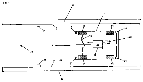
Referring to Fig 1, an unmanned personal rapid transit (PRT) vehicle 10 is
shown
travelling along a trackway 12. Although only a short length of straight
trackway is
shown, this preferably forms part of a PRT network, comprising a plurality of
vehicles
and a plurality of stations connected by the trackway. The system may include
junctions between trackway sections. Preferably, the stations are situated off
the main
trackway, so that vehicles of the system travel along the main trackway
between the
originating and destination stations for each joumey, without needing to stop
at
intermediate stations.
The vehicle 10 has four wheels 14, two of which steer the vehicle, by means of
a
steering system, indicated at 16. One or more of the wheels 14 is driven, for
example
by an electric motor powered by an onboard power supply such as a battery. An
ultrasonic distance sensor 18, 20, 22, 24 is positioned substantially at or
close to each
of the four corners of the vehicle 10. Two of the sensors 18, 20 are
positioned on one
side of the vehicle 10, and the other two sensors 22, 24 are positioned on the
other
side of the vehicle 10. The sensors on each side of the vehicle 10 are spaced
apart
sufficiently to detect the angular position of the vehicle relative to a
substantially
straight reference surface. The further the sensors 18, 20 and 22, 24 are
apart, the
CA 02684327 2009-10-16
WO 2008/129236 PCT/GB2008/001255
7
more accurate the determination of the angular position of the vehicle 10
relative to the
reference surface.
In other arrangements, the distance sensors may be lasers or any other
suitable
sensors for sensing distance. The sensors 18, 20,. 22, 24 are directed
laterally to the
direction of travel of the vehicle, which is indicated by the arrow A. A
control means in
the form of an onboard computer 26, including a memory 28, is connected to
receive
signals from each of the sensors 18, 20, 22, 24 and controls the steering
system 16.
The trackway 12 is bounded by kerbs 30, 32 running along either side of the
trackway,
the inner surfaces of which provide reference surfaces 31, 33. The distance to
the
reference surfaces 31,33 can be measured by the sensors 18, 20, 22, 24. The
kerbs
30, 32 are substantially continuous, but are interrupted at junctions to
enable a vehicle
10 to leave or join the trackway 12. Reference markers 34, 36 in the form of
protuberances (as shown) or undercuts (not shown) positioned in the sides of
the kerbs
30, 32 are positioned at known intervals along the trackway 12. The reference
markers 34, 36 are shown on both sides of the trackway 12, although it is
sufficient for
one reference marker to be positioned on one side only of the trackway 12. The
sensors 18, 20, 22, 24 are capable of detecting when a reference marker 34, 36
has
been reached, because there is a change in the sensed distance between each
sensor
and the reference surface, as the sensor moves past the reference marker.
Passive transponders, one of which is shown at 38, are laid under the trackway
at
known positions along the trackway, and a reader 40, capable of transmitting a
signal
to illuminate a transponder 38 and to receive and read a modulated signal
reflected
from the transponder 38, is mounted in the vehicle 10. The reader 40 is
connected to
the computer 26.
CA 02684327 2009-10-16
WO 2008/129236 PCT/GB2008/001255
8,
In use, a predetermined path of travel along a trackway 12 for a given vehicle
10 is
stored in the memory 28 of the onboard computer 26. The predetermined path can
be
obtained from the original track design parameters, or by manually steering a
vehicle
along the trackway 12 in a desired path whilst sensing the path followed and
recording
the distance travelled. In generating the predetermined path, reference sensor
readings for the sensors 18, 20, 22, 24 are stored, corresponding to different
positions
along the path. Also, the road width at different positions along the path is
determined
and stored.
An input device, for example a touch screen, or keypad is provided inside or
outside
the vehicle, to enable a passenger to choose a travel destination. When the
vehicle 10
is instructed to travel to a destination, the computer 26 controls the
steering system 16
to follow the appropriate predetermined path or combination of predetermined
paths to
reach the destination. The sensors 18, 20, 22, 24 measure the distance,
laterally of
the vehicle travel direction A, between the sensors and the sides of the kerbs
30, 32,
which provide a reference surface along the predetermined path. The computer
26
controls the steering system 16 to correct any lateral deviation from the
predetermined
path as detected by the sensors 18, 20, 22, 24.
When the vehicle encounters a curve in the trackway, the computer 26 will
control the
steering system 16 to cause the vehicle to negotiate the curve. If the vehicle
accurately follows the predetermined path, the output of the sensors 18, 20,
22, 24 will
confirm this, and no corrective operation of the steering system 16 will be
required.
However, if the vehicle deviates from the predetermine path, the output of the
sensors
18, 20, 22, 24 will detect this, and a corrective steering input will be
generated.
CA 02684327 2009-10-16
WO 2008/129236 PCT/GB2008/001255
9
The computer memory 28 can store a plurality of predetermined paths, any one
of
which can be selected. For example, paths into and out of each station in the
network
may be stored, as well as sections of the trackway between stations. A user
departing
from one station may select a desired destination, and the computer 26 will
then load
the paths required for that joumey into an active memory.
The vehicle guidance system can be used in a vehicle for use in any travel
network, by
storing the predetermined paths specific to the desired network in the
computer,
memory. If required, the trackway 12 can be super-elevated at bends, the super
elevation being determined by the desired operating speed of the vehicles and
the
layout of junctions.
The sensors 18, 20, 22, 24 operate continuously, thus enabling the computer 26
to
continuously correct for any lateral deviation from the predetermined path
along the
trackway 12. The difference or error between the actual position of the
vehicle 10, as
detected by the sensors 18, 20, 22, 24, and the ideal position of the vehicle
as
determined by the predetermined path are used to correct both the lateral
deviation of
the vehicle 10 from the predetermined path and also the vehicle alignment with
the
predetermined path. Ideally the vehicle 10 travels centrally along the
trackway 12, ie,
the predetermined path is spaced equidistantly between the kerbs 30, 32.
When the sensors 18, 20, 22, 24 detect a reference marker 34, 36, the computer
26
compares the actual position of the vehicle 10 in the predetermined path with
a
calculated position based on the measured distance travelled along to the
stored
predetermined path. Any deviation, or error, in the position is corrected by
the
computer 26.
CA 02684327 2009-10-16
WO 2008/129236 PCT/GB2008/001255
Referring now to Fig 2, an algorithm 42 is shown, which the computer 26 runs
to check
the integrity of the distance values to the kerbs 30, 32 provided by the
sensors 18, 20,
22, 24. Firstly, in ari operation indicated at 43, the computer 26 estimates
the position
of the vehicle 10 on the trackway 12, according to the predetermined path.
Then in a
5 step 44, the computer 26 compares the road width at the estimated position,
as
calculated from the outputs of the sensors 18, 20, 22, 24, with a road width
stored in
the computer memory 28, to calculate an error reading. If the error reading
between
the sensed road width and the stored road width is within a given tolerance,
ie, the road
width error is not greater than the tolerance, as shown in step 46, then the
sensor
10 measurements for all of the sensors are considered valid, as shown at 48.
If the error is outside the given tolerance, then in step 50 the computer
compares the
sensed distances of each sensor with estimated distances, shown as step 52.
The
estimated sensor readings are computed by correcting the stored predetermined
reference sensor readings for the estimated vehicle lateral and orientation
error from
the reference path. If the error for.a given sensor is within a given
tolerance, ie, less
than the tolerance, then that sensor measurement is valid, as shown at 56. If
not, then
the measurement for that sensor is treated as invalid. Any invalid
measurements are
ignored in step 58 by the computer 26 and the lateral position of the vehicle
is
established on the basis of the valid measurements.
If a sensor fails, or rubbish or other material accumulates on the trackway
12, then any
erroneous sensor readings are ignored, and the operation of the vehicle
guidance
system is unaffected, by virtue of use of the algorithm 42.
Referring back to Fig 1, if the computer 26 is unable to determine where along
the
stored predetermined path the vehicle is actually positioned on the trackway
12, then
CA 02684327 2009-10-16
WO 2008/129236 PCT/GB2008/001255
11
the computer may control the vehicle to move at a reduced speed along the
trackway
12. When travelling "blind", the vehicle has no predetermined path to follow,
and so
the steering system 16 is controlled to keep the vehicle 10 positioned
centrally between
the kerbs 30, 32 or at a minimum distance from the closest kerb. When a
transponder
38 is reached, the reader 40 identifies the modulated output from the
transponder 38,
and identifies the actual position of the vehicle 10 along the trackway 12. In
other
words, if a vehicle becomes temporarily lost, then by the use of the pre-
positioned
transponders 38, the computer 26 is able to re-establish the position of the
vehicle 10
and to resume travel at normal operating speed to the required destination.
Typically
the maximum operating speed is 25 kph.
If the system is used as part of a network, then a second computer (not shown)
can be
provided remote from the vehicle, which is in wireless communication with the
onboard
computer 26 of the vehicle 10. The remote computer can be arranged to control
or
partially control the onboard computer, thereby enabling remote control of the
vehicle.
The second computer can also be programmed to over-ride the control of the
onboard
computer 26, to start or stop the vehicle, for use, for example, in an
emergency by a
system operator who is overseeing the smooth running of a network of vehicles.
The second computer may also be used to set the route and schedule the
movement
of the vehicle so as to co-ordinate the operation of multiple vehicles.