Note: Descriptions are shown in the official language in which they were submitted.
CA 02685290 2009-11-06
WO 2008/144710
PCT/US2008/064318
SYSTEM AND METHOD FOR PERFORMING A DRILLING
OPERATION IN AN OILFIELD
BACKGROUND OF THE INVENTION
Field of the Invention
100011 "lbe
present invention relates to techniques for performing oilfield
operations relating to subterranean formations having reservoirs therein.
More particularly, the invention relates to techniques for performing drilling
operations involving an analysis of drilling equipment, drilling conditions
and
other oilfield parameters that impact the drilling operations.
Background of the Related Art
100021 Oilfield
operations, such as surveying, drilling, wireline testing,
completions and production, are typically performed to locate and gather
valuable downhole fluids. As shown in FIG. 1A, surveys are often performed
using acquisition methodologies, such as seismic scanners to generate maps
of underground structures. These structures are often analyzed to determine
the presence of subterranean assets, such as valuable fluids or minerals. This
information is used to assess the underground structures and locate the
formations containing the desired subterranean assets. Data collected from
the acquisition methodologies may be evaluated and analyzed to determine
whether such valuable items are present, and if they are reasonably
accessible.
100031 A
formation is a distinctive and continuous body of rock that it can be
mapped. Spaces between the rock grains ("porosity") of a formation may
contain fluids such as oil, gas or water. Connections between the spaces
("permeability") may allow the fluids to move through the formation.
Fon-nations with sufficient porosity and permeability to store fluids and
allow
the fluids to move are known as reservoirs. A structure is a geological
feature
that is created by deformation of the Earth's crust, such as a fold or fault,
a
1
CA 02685290 2009-11-06
WO 2008/144710 PCT/US2008/064318
feature within the rock itself (such as a fracture) or, more generally, an
arrangement of rocks. The above defmitions are taken from Schlumberger's
Oilfield Glossary (www.glossary.oilfieldslb.com), but in the industry, the
terms formation and structure may be loosely used synonymously.
[0004] As shown in FIGS. 1B-1D, one or more wellsites may be positioned
along the underground structures to gather valuable fluids from the
subterranean reservoirs. The wellsites are provided with tools capable of
locating and removing hydrocarbons from the subterranean reservoirs. As
shown in FIG. 1B, drilling tools are typically advanced from the oil rigs and
into the earth along a given path to locate the valuable downhole fluids.
During the drilling operation, the drilling tool may perform downhole
measurements to investigate downhole conditions. In some cases, as shown
in FIG. 1C, the drilling tool is removed and a wireline tool is deployed into
the wellbore to perform additional downhole testing. Throughout this
document, the term "wellbore" is used interchangeably with the term
"borehole."
100051 After the drilling operation is complete, the well may then be
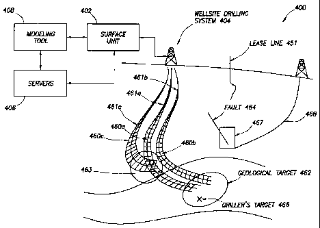
prepared
for production. As shown in FIG. 1D, wellbore completions equipment is
deployed into the wellbore to complete the well in preparation for the
production of fluid therethrough. Fluid is then drawn from downhole
reservoirs, into the wellbore and flows to the surface. Production facilities
are
positioned at surface locations to collect the hydrocarbons from the
wellsite(s). Fluid drawn from the subterranean reservoir(s) passes to the
production facilities via transport mechanisms, such as tubing. Various
equipments may be positioned about the oilfield to monitor oilfield
parameters and/or to manipulate the oilfield operations.
[0006] During the oilfield operations, data is typically collected for
analysis
and/or monitoring of the oilfield operations. Such data may include, for
example, subterranean formation, equipment, historical and/or other data.
Data concerning the subterranean formation is collected using a variety of
2
CA 02685290 2009-11-06
WO 2008/144710 PCT/US2008/064318
sources. Such formation data may be static or dynamic. Static data relates to
formation structure and geological stratigraphy that defines the geological
structure of the subterranean formation. Dynamic data relates to fluids
flowing through the geologic structures of the subterranean formation. Such
static and/or dynamic data may be collected to learn more about the
formations and the valuable assets contained therein.
10007] Sources used to collect static data may be seismic tools, =such as a
seismic truck that sends compression waves into the earth as shown in FIG.
1A. These waves are measured to characterize changes in the density of the
geological structure at different depths. This information may be used to
generate basic structural maps of the subterranean formation. Other static
measurements may be gathered using core sampling and well logging
techniques. Core samples are used to take physical specimens of the
formation at various depths as shown in FIG. 1B. Well logging involves
deployment of a downhole tool into the wellbore to collect various downhole
measurements, such as density, resistivity, etc., at various depths. Such well
logging may be perfonned using, for example, the drilling tool of FIG. 1B
and/or the wireline tool of FIG. 1C. Once the well is formed and completed,
fluid flows to the surface using production tubing as shown in FIG. 1D. As
fluid passes to the surface, various dynamic measurements, such as fluid flow
rates, pressure and composition may be monitored. These parameters may be
used to determine various characteristics of the subterranean formation.
100081 Sensors may be positioned about the oilfield to collect data
relating to
various oilfield operations. For example, sensors in the wellbore may monitor
fluid composition, sensors located along the flow path may monitor flow rates
and sensors at the processing facility may monitor fluids collected. Other
sensors may be provided to monitor downhole, surface, equipment or other
conditions. The monitored data is often used to make decisions at various
locations of the oilfield at various times. Data collected by these sensors
may
be further analyzed and processed. Data may be collected and used for
3
CA 02685290 2009-11-06
WO 2008/144710 PCT/US2008/064318
current or future operations. When used for future operations at the same or
other locations, such data may sometimes be referred to as historical data.
[0009] The processed data may be used to predict downhole conditions, and
make decisions concerning oilfield operations. Such decisions may involve
well planning, well targeting, well completions, operating levels, production
rates and other configurations. Often this information is used to determine
when to drill new wells, re-complete existing wells or alter wellbore
production.
[0010] Data from one or more wellbores may be analyzed to plan or predict
various outcomes at a given wellbore. In some cases, the data from
neighboring wellbores, or wellbores with similar conditions or equipment is
used to predict how a well will perform. There are usually a large number of
variables and large quantities of data to consider in analyzing wellbore
operations. It is, therefore, often useful to model the behavior of the
oilfield
operation to determine the desired course of action. During the ongoing
operations, the operating conditions may need adjustment as conditions
change and new information is received.
[0011] Techniques have been developed to model the behavior of geological
structures, downhole reservoirs, wellbores, surface facilities as well as
othcr
portions of the oilfield operation. Examples of modeling techniques are
shown in Patent/Application Nos. US5992519, W02004/049216,
W01999/064896, U S6313837, US2003/0216897, US2003/0132934,
US2005/0149307, and US2006/0197759. Typically, existing modeling
techniques have been used to analyze only specific portions of the oilfield
operation. More recently, attempts have been made to use more than one
model in analyzing certain oilfield operations. See, for example, US
Patent/Application Nos. US6980940, W02004/049216, US2004/0220846,
and US10/586,283.
[0012] Techniques have also been developed to predict and/or plan certain
oilfield operations, such as drilling operations. Examples of techniques for
4
CA 02685290 2009-11-06
WO 2008/144710 PCT/US2008/064318
generating drilling plans are provided in US Patent/Application Nos.
20050236184, 20050211468, 20050228905, 20050209886, and
20050209836. Some drilling techniques involve controlling the drilling
operation. Examples
of such drilling techniques are shown in
Patent/Application Nos. GB2392931 and GB2411669. Other drilling
techniques seek to provide real-time drilling operations. Examples of
techniques purporting to provide real time drilling are described in US
Patent/Application Nos. 7079952, 6266619, 5899958, 5139094, 7003439 and
5680906.
SUMMARY OF THE INVENTION
[00131 In
general, in one aspect, the invention relates to a method for
performing a drilling operation at a wellsite having a drilling rig configured
to
advance a drilling tool into a subsurface. The method steps include obtaining
a well trajectory associated with a first volume, obtaining information
related
to a first subsurface entity associated with a second volume, using a three-
dimensional relational comparison to determine that the first volume
intersects the second volume to define a first intersection information,
updating the well trajectory, based on the first intersection information, to
obtain an updated well trajectory, and advancing the drilling tool into the
subsurface based on the updated well trajectory.
[00141 In
general, in one aspect, the invention relates to a method for
performing a drilling operation at a wellsite having a drilling rig configured
to
advance a drilling tool into a subsurface. The method steps include obtaining
a geologic target based on geologic information, where the geologic target is
associated with a first volume, specifying a well target based on the geologic
target and geologic information associated with thc geologic target, where the
well target corresponds to a subset of the first volume, obtaining a well
trajectory based on the well target, and advancing the drilling tool into the
subsurface based on the well trajectory.
CA 02685290 2012-02-29
50866-70
[0015] In general, in one aspect, the invention relates to a system
for
performing a drilling operation at a wellsite having a drilling rig configured
to advance
a drilling tool into a subsurface. The system includes an interface configured
to
obtain a well trajectory, where the well trajectory is associated with a first
volume, and
configured to obtain information associated with a first subsurface entity,
where the
first subsurface entity is associated with a second volume. The system also
include a
modeling unit configured to determine that the first volume intersects the
second
volume using a three-dimensional relational comparison to obtain first
intersection
information and to update the well trajectory, based on the first intersection
information, to obtain an updated well trajectory. In addition, the system
includes a
controller configured to advance the drilling tool into the subsurface based
on the
updated well trajectory.
[0016] In general, in one aspect, the invention relates to a computer
program
product comprising a computer readable medium storing instructions executable
by
the computer to perform method steps for performing a drilling operation at a
wellsite
having a drilling rig configured to advance a drilling tool into a subsurface.
The
method steps include obtaining a well trajectory associated with a first
volume,
obtaining information related to a first subsurface entity associated with a
second
volume, using a three-dimensional relational comparison to determine that the
first
volume intersects the second volume to define a first intersection
information,
updating the well trajectory, based on the first intersection information,
obtaining an
updated well trajectory, and advancing the drilling tool into the subsurface
based on
the updated well trajectory.
[0016a] In general, in one aspect, the invention relates to a computer
program
product, comprising a computer readable medium storing instructions executable
by
the computer to perform method steps for performing a drilling operation at a
wellsite
having a drilling rig configured to advance a drilling tool into a subsurface,
the method
steps comprising: obtaining a geologic target based on geologic information,
wherein
the geologic target is associated with a first volume; specifying a well
target based on
6
CA 02685290 2012-02-29
50866-70
the geologic target and the geologic information associated with the geologic
target,
wherein the well target corresponds to a subset of the first volume; obtaining
a well
trajectory based on the well target, wherein the well trajectory is associated
with a
second volume; and obtaining information associated with a subsurface entity,
wherein the subsurface entity is associated with a third volume; determining
that the
second volume intersects the third volume using a three-dimensional relational
comparison to obtain intersection information; updating the well trajectory,
prior to
advancing the drilling tool, based on the intersection information to obtain
an updated
well trajectory; and advancing the drilling tool into the subsurface based on
the
updated well trajectory.
[0017] Other aspects and advantages will be apparent from the
following
description and the appended claims.
6a
CA 02685290 2009-11-06
WO 2008/144710 PCT/US2008/064318
BRIEF DESCRIPTION OF DRAWINGS
[0018] FIGS. 1A-1D depict a schematic view of an oilfield having
subterranean
structures containing reservoirs therein, various oilfield operations being
performed on the oilfield.
[00191 FIGS. 2A-2D show graphical depictions of data collected by the tools
of
FIGS. 1A-1D, respectively.
100201 FIG. 3 shows a schematic view, partially in cross-section of a
drilling
operation of an oilfield.
[0021] FIGS. 4-5 show exemplary schematic diagrams of systems for
performing a drilling operation of an oilfield.
[0022] FIGS. 6-9 show exemplary flow charts depicting methods for
performing a drilling operation of an oilfield.
[0023] FIG. 10 shows an exemplary representation of intersection
information
in a graphical format.
[0024] FIG. 11 shows an exemplary representation of intersection
information
in a tabular format.
[0025] FIG. 12 shows an exemplary representation of a well trajectory and a
sidetrack well trajectory associated with the well trajectory in a graphical
format.
DETAILED DESCRIPTION
[0026] Specific embodiments of the invention will now be described in
detail
with reference to the accompanying figures. Like elements in the various
figures are denoted by like reference numerals for consistency.
[0027] In the following detailed description of embodiments of the
invention,
numerous specific details are set forth in order to provide a more thorough
understanding of the invention. In other instances, well-known features have
not been described in detail to avoid obscuring the invention. The use of
7
CA 02685290 2009-11-06
WO 2008/144710 PCT/US2008/064318
"ST" and "Step" as used herein and in the Figures are essentially the same for
the purposes of this patent application.
[0028] The
present invention involves applications generated for the oil and gas
industry. FIGS. 1A-1D illustrate
an exemplary oilfield (100) with
subterranean structures and geological structures therein. More specifically,
FIGS. 1A-ID depict schematic views of an oilfield (100) having subterranean
structures (102) containing a reservoir (104) therein and depicting various
oilfield operations being perfonned on the oilfield. Various measurements of
the subterranean formation are taken by different tools at the same location.
These measurements may be used to generate information about the
formation and/or the geological structures and/or fluids contained therein.
0029] FIG. IA
depicts a survey operation being performed by a seismic truck
(106a) to measure properties of the subterranean formation. The survey
operation is a seismic survey operation for producing sound vibrations. In
FIG. 1A, an acoustic source (110) produces sound vibrations (112) that
reflect off a plurality of horizons (114) in an earth formation (116). The
sound vibration(s) (112) is (are) received in by sensors, such as geophone-
receivers (118), situated on the earth's surface, and the geophones-receivers
(118) produce electrical output signals, referred to as data received (120) in
FIG. 1A.
100301 The
received sound vibration(s) (112) arc representative of different
parameters (such as amplitude and/or frequency). The data received (120) is
provided as input data to a computer (122a) of the seismic truck (106a), and
responsive to the input data, the recording truck computer (122a) generates a
seismic data output record (124). The seismic data may be further processed,
as desired, for example by data reduction.
100311 FIG. 1B
depicts a drilling operation being performed by a drilling tool
(I06b) suspended by a rig (128) and advanced into the subterranean
formation (102) to form a wellhore (136). A mud pit (130) is used to draw
drilling mud into the drilling tool via a flow line (132) for circulating
drilling
8
CA 02685290 2009-11-06
WO 2008/144710 PCT/1JS2008/064318
mud through the drilling tool and back to the surface. The drilling tool is
advanced into the formation to reach the reservoir (104). The drilling tool is
preferably adapted for measuring downhole properties. The logging while
drilling tool may also be adapted for taking a core sample (133) as shown, or
removed so that a core sample (133) may be taken using another tool.
100321 A surface unit (134) is used to communicate with the drilling tool
and
offsite operations. The surface unit (134) is capable of communicating with
the drilling tool (106b) to send commands to drive the drilling tool (106b),
and to receive data therefrom. The surface unit (134) is preferably provided
with computer facilities for receiving, storing, processing, and analyzing
data
from the oilfield. The surface unit (134) collects data output (135) generated
during the drilling operation. Such data output (135) may be stored on a
computer readable medium (compact disc (CD), tape drive, hard disk, flash
memory, or other suitable storage medium). Further, data output (135) may
be stored on a computer program product that is stored, copied, and/or
distributed, as necessary. Computer facilities, such as those of the surface
unit, may be positioned at various locations about the oilfield and/or at
remote locations.
[0033] Sensors (S), such as gauges, may be positioned throughout the
reservoir,
rig, oilfield equipment (such as the downholc tool), or other portions of the
oilfield for gathering information about various parameters, such as surface
parameters, downhole parameters, and/or operating conditions. These
sensors (S) preferably measure oilfield parameters, such as weight on bit,
torque on bit, pressures, temperatures, flow rates, compositions, measured
depth, azimuth, inclination and other parameters of the oilfield operation.
100341 The information gathered by the sensors (S) may be collected by the
surface unit (134) and/or other data collection sources for analysis or other
processing. The data collected by the sensors (S) may be used alone or in
combination with other data. The data may bc collected in a database and all
9
CA 02685290 2009-11-06
WO 2008/144710 PCT/US2008/064318
or select portions of the data may be selectively used for analyzing and/or
predicting oilfield operations of the current and/or other wellbores.
[0035] Data outputs from the various sensors (S) positioned about the
oilfield
may be processed for use. The data may be may be historical data, real time
data, or combinations thereof. The real time data may be used in real time, or
stored for later use. The data may also be combined with historical data or
other inputs for further analysis. The data may be housed in separate
databases, or combined into a single database.
[0036] The collected data may be used to perform analysis, such as modeling
operations. For example, the seismic data output may be used to perform
geological, geophysical, and/or reservoir engineering simulations. The
reservoir, wellbore, surface, and/or process data may be used to perform
reservoir, wellbore, or other production simulations. The data outputs (135)
from the oilfield operation may be generated directly from the sensors (S), or
after some preprocessing or modeling. These data outputs (135) may act as
inputs for further analysis.
100371 The data is collected and stored at the surface unit (134). One or
more
surface units may be located at the oilfield, or linked remotely thereto. The
surface unit (134) may be a single unit, or a complex network of units used to
perform the necessary data management functions throughout the oilfield.
The surface unit (134) may be a manual or automatic system. The surface
unit (134) may be operated and/or adjusted by a user.
[0038] The surface unit (134) may be provided with a transceiver (137) to
allow
communications between the surface unit (134) and various portions of the
oilfield and/or other locations. The surface unit (134) may also be provided
with or functionally linked to a controller for actuating mechanisms at the
oilfield. The surface unit (134) may then send command signals to the
oilfield in response to data received. The surface unit (134) may receive
commands via the transceiver (137) or may itself execute commands to the
controller. A processor may be provided to analyze the data (locally or
CA 02685290 2009-11-06
WO 2008/144710 PCT/US2008/064318
remotely) and make the decisions to actuate the controller. In this manner,
the oilfield may be selectively adjusted based on the data collected. These
adjustments may be made automatically based on computer protocol, or
manually by an operator. In some cases, well plans and/or well placement
may be adjusted to select optimum operating conditions, or to avoid
problems.
[0039] FIG. 1C depicts a wireline operation being performed by a wireline
tool
(106c) suspended by the rig (128) and into the wellbore (136) of FIG. 1B.
The wireline tool (106c) is preferably adapted for deployment into a wellbore
(136) for performing well logs, performing downhole tests and/or collecting
samples. The wireline tool (106c) may be used to provide another method
and apparatus for performing a seismic survey operation. The wireline tool
(106c) of FIG. IC may have an explosive or acoustic energy source (144) that
provides electrical signals to the surrounding subterranean formations (102).
100401 The wireline tool (106c) may be operatively linked to, for example,
the
geophone-receivers (118) stored in the computer (122a) of the seismic
recording truck (106a) of FIG. 1.A. The wireline tool (106c) may also
provide data to the surface unit (134). As shown data output (135) is
generated by the wireline tool (106c) and collected at the surface. The
wirclinc tool (106c) may be positioned at various depths in the wellbore (136)
to provide a survey of the subterranean formation (l 02).
[0041] FIG. ID depicts a production operation being performed by a
production
tool (I 06d) deployed from a production unit or christmas tree (129) and into
the completed wellbore (136) of FIG.IC for drawing fluid from the downhole
reservoirs into the surface facilities (142). Fluid flows from reservoir (104)
through perforations in the casing (not shown) and into the production tool
(1 06d) in the wellbore (136) and to the surface facilities (142) via a
gathering
network (146).
[0042] Sensors (S), such as gauges, may be positioned about the oilfield to
collect data relating to various oilfield operations as described previously.
As
11
CA 02685290 2009-11-06
WO 2008/144710 PCT/US2008/064318
shown, the sensor (S) may be positioned in the production tool (106d) or
associated equipment, such as the christmas tree, gathering network, surface
facilities and/or the production facility, to measure fluid parameters, such
as
fluid composition., flow rates, pressures, temperatures, and/or other
parameters of the production operation.
10043] While only simplified wellsitc configurations arc shown, it will be
appreciated that the oilfield may cover a portion of land, sea and/or water
locations that hosts one or more wellsites. Production may also include
injection wells (not shown) for added recovery. One or more gathering
facilities may be operatively connected to one or more of the wellsites for
selectively collecting downhole fluids from the wellsite(s).
10044] During the production process, data output (135) may be collected
from
various sensors (S) and passed to the surface unit (134) and/or processing
facilities. This data may be, for example, reservoir data, wellbore data,
surface data, and/or process data.
100451 Throughout the oilfield operations depicted in FIGS. 1A-1D, there
are
numerous business considerations. For example, the equipment used in each
of these Figures has various costs and/or risks associated therewith. At least
some of the data collected at the oilfield relates to business considerations,
such as value and risk. This business data may include, for example,
production costs, rig time, storage fees, price of oil/gas, weather
considerations, political stability, tax rates, equipment availability,
geological
environment, and other factors that affect the cost of performing the oilfield
operations or potential liabilities relating thereto. Decisions may be made
and strategic business plans developed to alleviate potential costs and risks.
For example, an oilfield plan may be based on these business considerations.
Such an oilfield plan may, for example, determine the location of the rig, as
well as the depth, number of wells, duration of operation and other factors
that will affect the costs and risks associated with the oilfield operation.
12
CA 02685290 2009-11-06
WO 2008/144710 PCT/US2008/064318
[0046] While FIGS. 1A-ID depicts monitoring tools used to measure
properties
of an oilfield, it will be appreciated that the tools may be used in
connection
with non-oilfield operations, such as mines, aquifers or other subterranean
facilities. In addition, while certain data acquisition tools are depicted, it
will
be appreciated that various measurement tools capable of sensing properties,
such as seismic two-way travel time, density, resistivity, production rate,
etc.,
of the subterranean formation and/or its geological structures may be used.
Various sensors (S) may be located at various positions along the
subterranean formation and/or the monitoring tools to collect and/or monitor
the desired data. Other sources of data may also be provided from offsite
locations.
[0047] The oilfield configuration of FIGS. 1A-1D is not intended to limit
the
scope of the invention. Part, or all, of the oilfield may be on land and/or
sea.
In addition, while a single oilfield measured at a single location is
depicted,
the present invention may be utilized with any combination of one or more
oilfields, one or more processing facilities, and one or more wellsites.
[0048] FIGS. 2A-2D are graphical depictions of data collected by the tools
of
FIGS. 1A-1D, respectively. FIG. 2A depicts a seismic trace (202) of the
subterranean formation of FIG. IA taken by survey tool (106a). The seismic
trace measures the two-way response over a period of time. FIG. 2B depicts
a core sample (133) taken by the logging tool (106b). The core test typically
provides a graph of the density, resistivity, or other physical property of
the
core sample over the length of the core. FIG. 2C depicts a well log (204) of
the subterranean formation of FIG. 1C taken by the wireline tool (106c). The
wireline log typically provides a resistivity measurement of the formation at
various depts. FIG. 2D depicts a production decline curve (206) of fluid
flowing through the subterranean formation of FIG. 1D taken by the
production tool (106d). The production decline curve typically provides the
production rate (Q) as a function of time (t).
13
CA 02685290 2009-11-06
WO 2008/144710 PCT/US2008/064318
[0049] The respective graphs of FIGS. 2A-2C contain static measurements
that
describe the physical characteristics of the formation. These measurements
may be compared to determine the accuracy of the measurements and/or for
checking for errors. In this manner, the plots of each of the respective
measurements may be aligned and scaled for comparison and verification of
the properties.
[0050] FIG. 2D provides a dynamic measurement of the fluid properties
through the wellbore. As the fluid flows through the wellbore, measurements
are taken of fluid properties, such as flow rates, pressures, composition,
etc.
As described below, the static and dynamic measurements may be used to
generate models of the subterranean formation to determine characteristics
thereof.
[0051] The models may be used to create an earth model defining the
subsurface conditions. This earth model predicts the structure and its
behavior as oilfield operations occur. As new information is gathered, part or
all of the earth model may need adjustment.
[0052] FIG. 3 is a schematic view of a wellsite (300) depicting a drilling
operation, such as the drilling operation of FIG. 1B, of an oilfield in
detail.
The wellsite system (300) includes a drilling system (302) and a surface unit
(304). In the illustrated embodiment, a borehole (306) is formed by rotary
drilling in a msnner that is well known. Those of ordinary skill in the art
given the benefit of this disclosure will appreciate, however, that the
present
invention also finds application in drilling applications other than
conventional rotary drilling (e.g., mud-motor based directional drilling), and
is not limited to land-based rigs.
[0053] The drilling system (302) includes a drill string (308) suspended
within
the borehole (306) with a drill bit (310) at its lower end. The drilling
system
(302) also includes thc land-based platform and derrick assembly (312)
positioned over the borehole (306) penetrating a subsurface formation (F).
The assembly (312) includes a rotary table (314), kelly (316), hook (318), and
14
CA 02685290 2009-11-06
WO 2008/144710 PCT/US2008/064318
rotary swivel (319). The drill string (308) is rotated by the rotary table
(314),
energized by means not shown, which engages the kelly (316) at the upper
end of the drill string. The drill string (308) is suspended from hook (318),
attached to a traveling block (also not shown), through the kelly (316) and a
rotary swivel (319) which permits rotation of the drill string relative to the
hook.
[0054] The drilling system (302) further includes drilling fluid or mud
(320)
stored in a pit (322) formed at the well site. A pump delivers the drilling
fluid (320) to the interior of the drill string (308) via a port in the swivel
(319), inducing the drilling fluid to flow downwardly through the drill string
(308) as indicated by the directional arrow (324). The drilling fluid exits
the
drill string (308) via ports in the drill bit (310), and then circulates
upwardly
through the region between the outside of the drill string and the wall of the
borehole, called the annulus (326). In this manner, the drilling fluid
lubricates the drill bit (310) and carries formation cuttings up to the
surface as
it is returned to the pit (322) for recirculation.
10055] The drill string (308) further includes a bottom hole assembly
(BHA),
generally referred to as (330), near the drill bit (310) (in other words,
within
several drill collar lengths from the drill bit). The bottom hole assembly
(330) includes capabilities for measuring, processing, and storing
information, as well as communicating with the surface unit. =The BHA (330)
further includes drill collars (328) for performing various other measurement
functions.
[0056] Sensors (S) are located about the wellsite to collect data,
preferably in
real time, concerning the operation of the wellsite, as well as conditions at
the
wellsite. The sensors (S) of FIG. 3 may be the same as the sensors of FIGS.
1A-1D. The sensors of FIG. 3 may also have features or capabilities, of
monitors, such as cameras (not shown), to provide pictures of the operation.
Surface sensors or gauges (S) may be deployed about the surface systems to
provide information about the surface unit, such as standpipe pressure,
CA 02685290 2009-11-06
WO 2008/144710 PCT/US2008/064318
hookload, depth, surface torque, rotary rpm, among others. Downhole
sensors or gauges (S) are disposed about the drilling tool and/or wellbore to
provide information about downhole conditions, such as wellbore pressure,
weight on bit, torque on bit, direction, inclination, collar ipin, tool
temperature, annular temperature and toolface, among others. The
information collected by the sensors and cameras is conveyed to the various
parts of the drilling system and/or the surface control unit.
[0057] The
drilling system (302) is operatively connected to the surface unit
(304) for communication therewith. The BHA (330) is provided with a
communication subassembly (352) that communicates with the surface unit.
The communication subassembly (352) is adapted to send signals to and
receive signals from the surface using mud pulse telemetry. The
communication subassembly may include, for example, a transmitter that
generates a signal, such as an acoustic or electromagnetic signal, which is
representative of the measured drilling parameters. Communication between
the downhole and surface systems is depicted as being mud pulse telemetry,
such as the one described in US Patent No. 5517464, assigned to the assignee
of the present invention. It will be appreciated by one of skill in the art
that a
variety of telemetry systems may be employed, such as wired drill pipe,
electromagnetic or other known telemetry systems.
[0058] Typically,
the borehole (306) is drilled according to a drilling plan that
is established prior to drilling. The drilling plan typically sets forth
equipment, pressures, trajectories and/or other parameters that define the
drilling process for the wellsite (300). The drilling operation may then be
performed according to the drilling plan. However, as information is
gathered, the drilling operation may need to deviate from the drilling plan.
Additionally, as drilling or other operations are performed, the subsurface
conditions may change. The earth model may also need adjustment as new
information is collected.
16
CA 02685290 2009-11-06
WO 2008/144710 PCT/US2008/064318
100591 FIG. 4 is a schematic view of a system (400) for performing a
drilling
operation in an oilfield. As shown, the system (400) includes a surface unit
(402) operatively connected to a wellsite drilling system (404), servers (406)
operatively linked to the surface unit (402), and a modeling tool (408)
operatively linked to the servers (406). As shown, the wellsite drilling
System (404) is configured to advance a drilling tool into a subsurface.
100601 The subsurface may comprise subsurface entities. A subsurface entity
may correspond to a physical structure, a boundary, a trajectory, or some
other volume in the subsurface. Examples of a subsurface entity include, but
are not limited to, a lease boundary (451), a planned well trajectory (e.g.,
461c), a sidetrack well trajectory (not shown), an existing well trajectory
(e.g., 461a, 461b), a geologic formation (462), a geologic boundary, a
political boundary (e.g., a border), and some other subsurface entity capable
of being defined in an earth model. A sidetrack well trajectory (not shown)
may describe a sidetrack well that originates along an original well
trajectory
and diverges from the original well trajectory. In other words, the original
well trajectory is intended to intersect the sidetrack well trajectory (not
shown). In contrast, a planned well trajectory (e.g., 461c) is not intended to
intersect existing well trajectories (e.g., 461a, 461 b) and other subsurface
entities. In this case, a collision (463) may identified at the location the
planned well trajectory (e.g., 461c) and the existing well trajectory (e.g.,
461a) intersect.
100611 In one or more embodiments of the invention, the subsurface entities
may be defined based on geologic data (actual, historical, or a combination
thereof), lease boundaries, political boundaries, and/or some other data
capable of defining a volume in the subsurface. The geologic data may be
data measured by the sensors (S) of the wellsite as described with respect to
FIGS. 1A-1D and 3. The geologic data may also be data received from other
sources (e.g., historical data obtained from an adjacent well).
17
CA 02685290 2009-11-06
WO 2008/144710 PCT/US2008/064318
[00621 Information associated with a subsurface entity may also define a
volume of the subsurface. In this case, an earth model may define both
subsurface entities and information associated with subsurface entities.
Examples of information associated with a subsurface entity include, but is
not limited to, uncertainty, a separation factor, a target area, or some other
information associated with a subsurface entity capable of being defined in an
earth model.
[0063] More specific examples of information associated with a subsurface
entity include: a planned well trajectory (e.g., 461c) may be associated with
a
volume of uncertainty (e.g., 460c); an existing well trajectory (historical
well
trajectory) (e.g., 461a, 461b) may be associated with a volume of uncertainty
(e.g., 460a, 460b) based on accuracy of tools used in the drilling rig
accuracy
of geologic data, or other factors that may affect the trajectory of the well;
a
geologic formation may be associated with a separation factor volume
describing a volume encompassing the geologic formation that should be
avoided during drilling operations; and a geologic formation may be
associated with a geologic target (462) specifying the geologic formation as a
target for a drilling operation. In the case of a geologic target (462), a
well
target (466) may further be specified within the geologic target (462), where
the well target (466) describes the optimal portion of the geologic target
(462)
for the drilling operation.
[0064] The volume of uncertainty (460a, 460b, 460c) may correspond to a
potential volume in which the actual well may be located. Specifically, the
volume of uncertainty (460a, 460b, 460c) may correspond to a bounding cone
of uncertainty defined using a group of ellipsoids of uncertainty. Further,
each ellipsoid of uncertainty may describe the uncertainty at a point along a
well trajectory (461a, 461 b, 461c). Alternatively, the volume of uncertainty
may be based on some other information (e.g., separation factor, preferred
extent, maximum extent, or some other information associated with a
subsurface entity). For example, in the case of a fault (464), the separation
18
CA 02685290 2009-11-06
WO 2008/144710 PCT/US2008/064318
factor (467) may correspond to a minimum allowable distance between the
fault (464) and a planned well trajectory (e.g., 468).
100651 FIG. 5 is a detailed schematic view of the system (400) of FIG. 4
for
performing a drilling operation of an oilfield. Similar to what is shown in
FIG. 4, the system (400) includes a surface unit (402) operatively connected
to a wellsitc drilling system (404), servers (406) operatively linked to the
surface unit (402), and a modeling tool (408) operatively linked to the
servers
(406). As shown, communication links (410) are provided between the
wellsite drilling system (404), surface unit (402), servers (406), and
modeling
tool (408). A variety of links may be provided to facilitate the flow of data
through the system. For example, the communication links (410) may
provide for continuous, intermittent, one-way, two-way and/or selective
communication throughout the system (400). The communication links (410)
may be of any type, such as wired, wireless, etc.
[0066] The wellsite drilling system (404) and surface unit (402) may be the
same as the wellsite drilling system and surface unit of FIG. 3. The surface
unit (402) is preferably provided with an acquisition component (412), a
controller (414), a display unit (416), a processor (418) and a transceiver
(420). The acquisition component (412) collects and/or stores data of the
oilfield. This data may be data measured by the sensors (S) of the wellsite as
described with respect to FIG. 3. This data may also be data received from
other sources. The data may also be stored on a computer readable medium
such as a compact disk, DVD, optical media, volatile storage, non-volatile
storage, or any other medium configured to store the data.
100671 The controller (414) is enabled to enact commands at the oilfield.
The
controller (414) may be provided with an actuation mechanism that can
perform drilling operations, such as steering, advancing, or otherwise taking
action at the wellsite. Commands may be generated based on logic of the
processor (418), or by conunands received from other sources. The processor
(418) is preferably provided with features for manipulating and analyzing the
19
CA 02685290 2009-11-06
WO 2008/144710 PCT/US2008/064318
data. The processor (418) may be provided with additional functionality to
perform oilfield operations.
[0068] A display unit (416) may be provided at the wellsite and/or remote
locations for viewing oilfield data (not shown). The oilfield data represented
by a display unit (416) may be raw data, processed data and/or data outputs
generated from various data. The display unit (416) is preferably adapted to
provide flexible views of the data, so that the screens depicted may be
customized as desired. A user may determine the desired course of action
during drilling based on reviewing the displayed oilfield data. The drilling
operation may be selectively adjusted in response to the display unit (416).
The display unit (416) may include a two dimensional display for viewing
oilfield data or defining oilfield events. For example, the two dimensional
display may correspond to an output from a printer, plot, a monitor, or
another device configured to render two dimensional output. The display unit
(416) may also include a three- dimensional display for viewing various
aspects of the drilling operation. At least some aspect of the drilling
operation is preferably viewed in real time in the three-dimensional display.
For example, the three dimensional display may correspond to an output from
a printer, plot, a monitor, or another device configured to render three
dimensional output.
[0069] The transceiver (420) is configured to for provide data access to
and/or
from other sources. The transceiver (420) is also configured to enable
communication with other components, such as the servers (406), the wellsite
drilling system (404), surface unit (402) and/or the modeling tool (408).
[0070] The servers (406) may be used to transfer data from one or more
wellsites to the modeling tool (408). As shown, the server (406) includes
onsite servers (422), a remote server (424) and a third-party server (426).
The onsite servers (422) may be positioned at the wellsite and/or other
adjacent locations for distributing data from the surface unit (402). The
remote server (424) is positioned at a location away from the oilfield and
CA 02685290 2009-11-06
WO 2008/144710 PCT/1JS2008/064318
provides data from remote sources. The third-party server (426) may be
onsite or remote, but is operated by a third-party, such as a client.
[0071] The servers (406) are preferably capable of transferring drilling
data
(e.g., logs), drilling events, trajectory, and/or other oilfield data (e.g.,
seismic
data, historical data, economics data, or other data that may be of use during
analysis). The type of server is not intended to limit the invention.
Preferably the system is adapted to function with any type of server that may
be employed.
[0072] The servers (406) communicate with the modeling tool (408) as
indicated by the communication links (410). As indicated by the multiple
arrows, the servers (406) may have separate communication links (410) with
the modeling tool (408). One or more of the servers (406) may be combined
or linked to provide a combined communication link (410).
100731 The servers (406) collect a wide variety of data. The data may be
collected from a variety of channels that provide a certain type of data, such
as well logs. The data from the servers (406) is passed to the modeling tool
(408) for processing. The servers (406) may also be used to store and/or
transfer data.
100741 The modeling tool (408) is operatively linked to the surface unit
(402)
for receiving data therefrom. In some cases, the modeling tool (408) and/or
server(s) (406) may be positioned at the wellsite. The modeling tool (408)
and/or server(s) (406) may also be positioned at various locations. The
modeling tool (408) may be operatively linked to the surface unit via the
server(s) (406). The modeling tool (408) may also be included in or located
near the surface unit (402).
100751 The modeling tool (408) includes an interface (430), a processing
unit
(432), a modeling unit (448), a data repository (434) and a data rendering
unit
(436). The interface (430) communicates with other components, such as the
servers (406). The interface (430) may also permit communication with other
21
CA 02685290 2009-11-06
WO 2008/144710 PCT/US2008/064318
oilfield or non-oilfield sources. The interface (430) receives the data and
maps the data for processing. Data from servers (406) typically streams
along predefined channels which may be selected by the interface (430).
[0076] As depicted in FIG. 5, the interface (430) selects the data channel
of the
server(s) (406) and .receives the data. The interface (430) also maps the data
channels to data from the wellsite. The interface (430) may also receive data
from a data file (i.e., an extensible markup language (XML) file, a dBase
file,
or some other data file format). The data may then be passed to the
processing modules (442) of the modeling tool (408). The data may be
iminediately incorporated into the modeling tool (408) for real-time sessions
or modeling. The interface (430) creates data requests (for example surveys,
logs and risks), displays the user interface, and handles connection state
events. The interface (430) also instantiates the data into a data object for
processing. The interface (430) may receive a request from at the surface
unit (402) to retrieve data from the servers (406), the well unit, and/or data
files.
[0077] The processing unit (432) includes formatting modules (440),
processing modules (442), and utility modules (446). These modules are
designed to manipulate the oilfield data for real-time analysis.
[0078] The formatting modules (440) are used to confonn the data to a
desired
format for processing. Incoming data may need to be formatted, translated,
converted or otherwise manipulated for use. The formatting modules (440)
are configured to enable the data from a variety of sources to be formatted
and used so that the data processes and displays in real time.
100791 The utility modules (446) provide support functions to the drilling
system. The utility modules (446) include the logging component (not
shown) and the user interface (Ul) manager component (not shown). The
logging component provides a common call for all logging data. The logging
component allows the logging destination to be set by the application. The
logging component may also be provided with other features, such as a
22
CA 02685290 2009-11-06
WO 2008/144710 PCT/US2008/064318
debugger, a messenger, and a warning system, among others. The debugger
sends a debug message to those using the system. The messenger sends
information to subsystems, users, and others. The information may or may
not interrupt the operation and may be distributed to various locations and/or
users throughout the system. The warning system may be used to send error
messages and warnings to various locations and/or users throughout the
system. In some cases, the warning messages may interrupt the process and
display alerts.
[0080j The UI manager component creates user interface elements for
displays.
The UI manager component defines user input screens, such as menu items,
context menus, toolbars, and settings windows. The user manager component
may also be used to handle events relating to these user input screens.
100811 The processing module (442) is used to analyze the data and generate
outputs. As described above, the data may include static data, dynnmic data,
historic data, real-time data, or other types of data. Further, the data may
relate to various aspects of the oilfield operations, such as formation
structure, geological stratigraphy, core sampling, well logging, density,
resistivity, fluid composition, flow rate, downhole condition, surface
condition, equipment condition, or other aspects of the oilfield operations.
100821 The processing modules (442) may be used to analyze these data for
generating an earth model and making decisions at various locations of the
oilfield at various times. For example, an oilfield event, such as drilling
event, risk, lesson learned, best practice, or other types of oilfield events
may
be defined from analyzing these data. Examples of drilling event include
stuck pipe, loss of circulation, shocks observed, or othcr types of drilling
events encountered in real time during drilling at various depths and lasting
for various durations. Examples of risk includes potential directional control
issue from fbnnation dips, potential shallow water flow issue, or other types
of potential risk issues. For example, the risk issues may be predicted from
analyzing the earth model based on historic data compiled prior to drilling or
23
CA 02685290 2009-11-06
WO 2008/144710 PCT/US2008/064318
real-time data acquired during drilling. Lessons teamed and best practice
may be developed from neighboring wellbores with similar conditions or
equipments and defined as oilfield events for reference in determining the
desired course of action during drilling.
100831 The data repository (434) may store the data for the modeling unit.
The
data may be stored in a format available for use in real-time (e.g.,
information
is updated at approximately the same rate the information is received). The
data is generally passed to the data repository from the processing
component. The data may be persisted in the file system (e.g., as an
extensible markup language (XML) file) or in a databasc. The system (400)
may determine which storage is the most appropriate to use for a given piece
of data and stores the data in a manner to enable automatic flow of thc data
through the rest of the system in a seamless and integrated fashion. The
system (400) may also facilitates manual and automated workflows (such as
Modeling, Geological & Geophysical workflows) based upon the persisted
data.
100841 The data rendering unit (436) performs rendering algorithm
calculation
to provide one or more displays for visualizing the data. The displays may be
presented to a user at the display unit (416). The data rendering unit (436)
may include a two-dimensional canvas, a three-dimensional canvas, a well
section canvas or other canvases as desired.
[0085] The data rendering unit (436) may selectively provide displays
composed of any combination of one or more canvases. The canvases may or
may not be synchronized with each other during display. The data rendering
unit (436) may be provided with mechanisms for actuating various canvases
or other functions in the system. Further, the data rendering unit (436) may
be configured to provide displays representing the oilfield events generated
from the real-time drilling data acquired in real-time during drilling, the
oilfield events generated from historic data of neighboring wellbores
compiled over time, the current trajectory of the wellbore during drilling,
the
24
CA 02685290 2009-11-06
WO 2008/144710 PCT/US2008/064318
earth model generated from static data of subterranean geological features,
and/or any combinations thereof. In addition, the data rendering unit (436)
may be configured to selectively adjust the displays based on real-time
drilling data such as the drilling tool of the drilling system (404) advances
into a subterranean formation.
[0086] The modeling unit (448) performs modeling functions for generating
complex oilfield outputs. The -modeling unit (448) may be a conventional
modeling tool capable of performing modeling functions, such as generating,
analyzing and manipulating earth models. The earth models typically include
exploration and production data, such as that shown in FIGS. 2A-2D. The
modeling unit (448) may be used to perform relational comparisons of
subsurface entities. The modeling unit (448) may also be used to update an
earth model based on relational comparisons of the subsurface entities.
Alternatively, the modeling unit (448) may be used to update an earth model
based on input from a user.
[0087] While specific components are depicted and/or described for use in
the
units and/or modules of the modeling tool (408), it will be appreciated that a
variety of components with various functions may be used to provide the
formatting, processing, utility and coordination functions necessary to
provide real-time processing in the modeling tool (408). The components
may have combined functionalities and may be implemented as software,
hardware, firmware, or combinations thereof.
[0088] Further, components (e.g., the processing modules (442) and the data
rendering unit (436)) of the modeling tool (408) may be located in an onsite
server (422) or in distributed locations where remote server (424) and/or
third-party server (426) may be involved. The onsite server (422) may be
located within the surface unit (402).
[0089] FIG. 6 shows a flow chart depicting a method for peiforming a
drilling
operation of an oilfield. The method may be performed using, for example,
the system of FIG. 5. The method may involve obtaining a geologic target
CA 02685290 2009-11-06
WO 2008/144710 PCT/US2008/064318
and a corresponding volume based on geologic information (ST 602),
specifying a well target based on the geologic target, where the well target
is
a subset of the volume associated with the geologic target (ST 604), obtaining
a well trajectory based on the well target (ST 606), and advancing a drilling
tool based on the well trajectory (ST 608).
[0090] The geologic target may be obtained (ST 602) from a variety of
sources.
As discussed with respect to FIGS. 3 and 5, geologic information may be
generated by sensors (S) at the wellsite or from other sources. The geologic
information may be transferred directly to the modeling tool (408 in FIG. 5),
or transferred to the modeling tool via at least one of the servers (406 in
FIG.
5). The geologic information is then generally received by the interface of
the modeling tool. The geologic information may be defined as a volume by
the processing modules (442 in FIG. 5). The volume and geologic
information may then be presented as output. Specifically, the output may be
provided by the data rendering unit (436 in FIG. 5) in the modeling tool and
presented to a user at the display unit (416 in FIG. 5) in the surface unit
(402). This volume may then be designated by the user as a geologic target
based on the geologic information.
[0091] Those skilled in the art will appreciate that the volume (and/or
geological target) may be designated by the user based on a variety of
geologic information (e.g., porosity, permeability, etc.). For example, the
user may be presented with a number of potential volumes and then designate
a geologic target from the volumes based on their corresponding geologic
information.
100921 The well target may then be obtained (ST 604) based on thc geologic
target and the geologic information. The well target may correspond to a
subset of the volume associated with the geologic target. In this case, the
user may interact with the display unit (416 in FIG. 5) to specify the well
target. Specifically, the user may specify a subset of the volume associated
with the geologic target using the display unit to obtain the well target (416
in
26
CA 02685290 2009-11-06
WO 2008/144710 PCT1US2008/064318
FIG. 5). Further, the subset of the volume associated with the geologic target
may be specified based on the geologic information (e.g., region of volume
with highest porosity, etc.). In another example, the modeling unit (448 on
FIG. 5) may specify the well target automatically based on the geologic target
and geologic information.
100931 Optionally, the user inay also provide a confidence factor
associated
with the well target. The confidence factor may correspond to positional
uncertainty of the wellbore at the depth of the well target during a drilling
operation.
[0094] Next, the well trajectory may be obtained based on the well target
(ST
606). The modeling unit (448 on FIG. 5) may generate the well trajectory
based, in part, on the well target. In another example, the user may generate
the well trajectory based on the well target and then send the well trajectory
to the interface (430 on FIG. 5) using the display unit (416 on FIG. 5). The
well trajectory may be defined as a second volume by the processing modules
(442 in FIG. 5). The second volume may also be presented as output.
100951 The drilling tool may then be advanced based on the well trajectory
(ST
608) by a variety of methods. The user may advance the drilling tool using
the controller (414 on Fla 5) based on the well trajectory. The data
rendering module may re-calculate the rendering algorithm to adjust the well
trajectory display in real-time. A desired course of action may be determined
based on the updated display to adjust the drilling operation.
100961 The steps of the method in FIG. 6 are depicted in a specific ordcr.
However, it will be appreciated that the steps may be performed
simultaneously or in a different order or sequence.
100971 FIG. 7 shows a flow chart depicting a method for performing a
drilling
operation of an oilfield. The method may he performed using, for example,
the system of FIG. 5.
27
CA 02685290 2009-11-06
WO 2008/144710 PCT/US2008/064318
[00981 The method involves obtaining a well trajectory and a Corresponding
first volume (ST 702), obtaining subsurface entity information and a
corresponding second volume (ST 704), determining whether the first volume
intersects the second volume (ST 706), presenting output comprising
intersection information if the first volume intersects the second volume (ST
708), updating the well trajectory based on the intersection information to
obtain an updated well trajectory (ST 710), and advancing the drilling tool
based on the updated well trajectory (ST 712).
[00991 The well trajectory and corresponding first volume may be obtained
(ST
702) from a variety of sources. For example, the well trajectory may be
obtained as described in ST 602-ST 606 in FIG. 6 above. In another
example, the well trajectory may be sent to the interface (430 in FIG. 5) or
retrieved from a data repository (434 on FIG. 5). The well trajectory may
correspond to a planned well trajectory. Next, the first volume may be
obtained by the processing module (442 in FIG. 5) based on the well
trajectory. The first volume may describe the uncertainty associated with the
well trajectory. Further, the first volume may then be presented as output.
Specifically, the output may be provided by the data rendering unit (436 in
FIG. 5) in the modeling tool and presented to a user at the display unit (416
in
FIG. 5) in the surface unit.
[00100] Optionally, the first volume may be updated. For example, the first
volume may be updated based on anti-collision rules (e.g., a separation
factor,
a preferred angle at a well target, a maximum possible extent, or a preferred
extent). Alternatively, the first volume may bc updated when the well
trajectory is updated.
[00101] The subsurface entity information and corresponding second volume
may be obtained (ST 704) from a variety of sources. As discussed with
respect to FIGS. 3 and 5, subsurface entity infonnation may be generated by
sensors (S) at the wellsite or from other sources. The subsurface entity
information may be transferred directly to the modeling tool (408 in FIG. 5),
28
CA 02685290 2009-11-06
WO 2008/144710 PCT/US2008/064318
or transferred to the modeling tool via at least onc of the servers (406 in
FIG.
5). The subsurface entity information is then generally received by the
interface of the modeling tool. The second volume may then be obtained by
the processing module (442 in FIG. 5) based on the subsurface entity
information. The second volume may describe a separation factor associated
with the subsurface entity. In another example, the second volume may
describe a variety information associated with a subsurface entity (e.g.,
separation factor, uncertainty, or some other information capable of being
defined as a volume). At this stage, the second voltune may also be presented
as output.
100102] Next, a determination may be made as to whether the first volume
intersects the second volume (ST 706). More specifically, a three
dimensional relational comparison may be used by the modeling unit (448 in
FIG. 5) to determine whether the first volume intersects the second volume.
If the first volume does not intersect the volume, the drilling tool may be
advanced based on the well trajectory (ST 714).
[00103] Optionally, a determination may be made as to whether the
intersection
data is associated with a sidetrack well trajectory (ST 707). Specifically,
the
subsurface entity may correspond to the sidetrack well trajectory. In this
case, the well trajectory may not need to be updated based on the intersection
information. Accordingly, the drilling tool may then be advanced based on
the well trajectory (ST 714).
[00104] Next, if the first volume does intersect the second volume, output
including intersection information may also be presented (ST 708).
Specifically, the output may be presented to the user at the display unit (416
in FIG. 5). For example, the output may be presented in a tabular format
displaying the intersection information. Optionally, presenting the output
may also include identifying the intersection at the display unit (416 in FIG.
5). Specifically, identifying the intersection may include highlighting a
volume portion associated with the first volume, where the volume portion
29
CA 02685290 2009-11-06
WO 2008/144710 PCT/US2008/064318
intersects the second volume. In another example, only the volume portion
associated with the first volume may be presented as output, where the
presented volume portion intersects the second volume.
[00105] The well trajectory may be updated based on the intersection
information to obtain an updated well trajectory (ST 710). The user may
update the well trajectory based on the intersection information to obtain the
updated well trajectory and then send the updated well trajectory to the
interface (430 in FIG. 5). In another example, the user may update the well
trajectory based on the intersection information using the display unit (416
in
FIG. 5). In another example, the modeling unit (448 in FIG. 5) may
automatically update the well trajectory based on the intersection information
to obtain the updated well trajectory. The updated well trajectory may also
be presented as output.
[00106] Those skilled in the art will appreciate that ST 706-ST 712 may be
repeated any number of times until a determination is made that the well
trajectory (i.e., first volume) does not intersect the subsurface entity
(i.e.,
second volume). In other words, the well trajectory may be updated
iteratively in ST 710 until the well trajectory no longer intersects the
subsurface entity.
1001071 Next, the drilling tool may be advanced based on the updated well
trajectory (ST 712). The user may advance the drilling tool using the
controller (414 on FIG. 5) based on the updated well trajectory. The data
rendering module may re-calculate the rendering algorithm to adjust the
updated well trajectory display in real time. A desired course of action may
be determined based on the updated display to adjust the drilling operation.
[00108] The steps of the method in FIG. 7 are depicted in a specific order.
However, it will be appreciated that the steps may be performed
simultaneously or in a different order or sequence.
CA 02685290 2009-11-06
WO 2008/144710 PCT/US2008/064318
[00109] FIG. 8 shows a flow chart of a method for detennining if a first
volume
intersects a second volume. The method may be performed using, for
example, the system of FIG. 5. Further, the method may describe the
determination step as discussed above in ST 706 of FIG. 7.
[00110] The method involves dividing the first volume to obtain a first
plurality
of volume portions (ST 802), dividing the second volume to obtain a second
plurality of volume portions (ST 804), and determining at least one of the
first plurality of volume portions, which intersects with at least one of the
second plurality of volume portions (ST 806).
[00111] The first volumes may be divided into the first plurality of volume
portions (ST 802) by a variety of methods. If the first volume is associated
with a well trajectory, the first volume may be divided based on well
trajectory stations associated with the well trajectory to obtain the first
plurality of volume portions. Alternatively, the first volume may be divided
into regular sized volumes based on a user-defined preference to obtain the
first plurality of volume portions. Similar to the first volume, the second
volume may also be divided into the second plurality of volume portions (ST
804) as discussed in above ST 802.
[00112] Ncxt, a determination may be made regarding whether at least one of
the
first plurality of volume portions intersects with at least one of the second
plurality of volume portions (ST 806). More specifically, each of the first
plurality of volume portions may be compared to each of the second plurality
of volume portions in an iterative process. Further, if it is determined that
one of the first plurality of volume intersects one of the second plurality of
volume portions, it may be determined that the first volume intersects the
second volume, and the process may end.
[00113] The steps of the method in FIG. 8 are depicted in a specific order.
However, it will be appreciated that the steps may be performed
simultaneously or in a different order or sequence.
31
CA 02685290 2009-11-06
WO 2008/144710 PCT/US2008/064318
[00114] FIG. 9 shows a flow chart of a method for determining which of the
at
least one of a first plurality of volume portions intersects at least one of a
second plurality of volume portions. The method may be performed using, for
example, the system of FIG. 5. Further, the method may describe the
determination step discussed above in ST 806 of FIG. 8.
[001151 The method involves defining a first bounding shape comprising one
of
a first plurality of volume portions (ST 902), defining a second bounding
shape comprising one of a second plurality of volume portions (ST 904),
determining the first bounding shape intersects the second bounding shape
(ST 906), obtaining a first triangle associated with the one of the first
plurality of volume portions (ST 908), obtaining a second triangle associated
with the one of the second plurality of volume portions (ST 910), determining
that the first triangle intersects the second triangle (ST 912), collecting
intersection information for the one of the first plurality of volume portions
and for the one of the second plurality of volume portions (ST 914).
[00116] The first bounding shape comprising one of a first plurality of
volume
portions may be defmed (ST 902). The first bounding shape may correspond
to a variety of shapes. For example, the first bounding shape may correspond
to a cylinder, a sphere, a box, a cone, a cube, a spheroid, or some other
regular or irregular three-dimensional polygon. Further, the one of a first
plurality of volume portions may comprise of a first plurality of triangles.
The second bounding shape comprising one of a second plurality of volume
portions may then be defined (ST 904). Similar to the first bounding shape,
the second bounding shape may correspond to a variety of shapes as
discussed in ST 902 above. Further, the one of a second plurality of volume
portions may comprise of a second plurality of triangles.
1001171 Next, a determination may be made as to whether the first bounding
shape intersects the second bounding shape (ST 906). If the first bounding
shape does not intersect the second bounding shape, then it is determined that
the volume portions do not intersect and the process ends. Those skilled in
32
CA 02685290 2009-11-06
WO 2008/144710 PCT/US2008/064318
the art will appreciate that the bounding shapes may be much simpler then
their corresponding volume portions. Accordingly, the bounding shapes may
be used to rapidly determine whether their corresponding volume portions do
not intersect without requiring an expensive comparison of the triangles
contained in the corresponding volume portions.
[00118] If the first bounding shape does intersect the second bounding
shape,
then a first triangle of the first plurality of triangles may be obtained (ST
908). Further, a second triangle of the second plurality of triangles may also
be obtained (ST 910).
[00119] At this stage, a determination may be made as to whether the first
triangle intersects the second triangle (ST 912). If the first triangle does
intersect the second triangle, then it may be determined whether the
corresponding volume portions intersect. Further, intersection information
for the one of the first plurality of volume portions and for the one of the
second plurality of volume portions may be collected (ST 914). Intersection
information may include a reference to a first subsurface entity associated
the
one of the first plurality of volume portions, a reference to a second
subsurface entity associated the one of the second plurality of volume
portions, coordinate information related to the one of the first plurality of
volume portions, and/or coordinate information related to the one of the
second plurality of volume portions. Optionally, the one of the first
plurality
of volume portions may be highlighted at the display unit (416 in FIG. 5).
[00120] If the first triangle does not intersect the second triangle, then
Steps 908-
912 may be repeated until one of the first plurality of triangles is
detennined
to intersect one of the second plurality of triangles or until each triangle
of thc
first plurality of triangles has been determined to not intersect each
triangle of
thc second plurality of triangles.
[00121] The steps of the method in FIG. 9 are depicted in a specific order.
However, it will be appreciated that the steps may be performed
simultaneously or in a different order or sequence.
33
CA 02685290 2009-11-06
WO 2008/144710 PCT/US2008/064318
[00122] FIG. 10 shows an exemplary graphical representation of output
(1000)
as described in ST 708 of FIG. 7 above. Here, the graphical representation
includes a first volume (1002) and a second volume (1004). For example, the
first volume may define a volume of uncertainty associated with a first well
trajectory, and the second volume may define a volume of uncertainty
associated with a second well trajectory. Further, a first volume portion
associated with the first volume and a second volume portion associated with
the second volume may be identified by highlighting the first volume portion
and the second volume portion based on intersection information (1006) as
described in ST 708 of FIG. 7.
[00123] FIG. 11 shows an exemplary tabular representation of output (1100)
as
collected at ST 914 in FIG. 9. The output (1100) includes intersection
infomiation related to a number of subsurface entities. More specifically, the
output (1100) specifies that three intersections (1102) between subsurface
entities have been detected. Further, the output (1100) includes an entry for
each of the three subsurface entities (e.g., 1104), where each entry (e.g.,
1104) specifies a variety of subsurface entity information (e.g., subsurface
entity, symbol for displaying the subsurface entity, the number of
intersections occurring with the subsurface entity, etc.). The details of each
intersection (1106) may be displayed under their corresponding subsurface
entity entry (e.g., 1104). The details of an intersection may specify a
variety
of intersection information (e.g., subsurface entities associated with the
intersection, measured depth information, true vertical depth information,
etc.). The output (1100) may be presented to the user in a display as
described in ST 708 of FIG. 7 above.
[00124] FIG. 12 shows an exemplary graphical representation of output
(1200)
including a well trajectory and a sidetrack well trajectory associated with
the
well trajectory. The graphical representation of output (1200) also includes a
first volume (1202) associated with the well trajectory and a second volume
(1204) associated with the sidetrack well trajectory. The first volume (1202)
34
CA 02685290 2009-11-06
WO 2008/144710 PCT/US2008/064318
may describe uncertainty associated with the well trajectory. The second
volume (1204) may describe uncertainty associated with the sidetrack well
trajectory originating at the well trajectory.
100125] It will be understood from the foregoing description that various
modifications and changes may be made in the preferred and alternative
embodiments of the present invention without departing from its true spirit.
For example, the method may be performed in a different sequence, and the
components provided may be integrated or separate.
[00126] This description is intended for purposes of illustration only and
should
not be construed in a limiting sense. The scope of this invention should be
determined only by the language of the claims that follow. The term
"comprising" within the claims is intended to mean "including at least" such
that the recited listing of elements in a claim are an open group. "A," "an"
and other singular terms are intended to include the plural forms thereof
unless specifically excluded.
[00127] While the invention has been described with respect to a limited
number
of embodiments, those skilled in the art, having benefit of this disclosure,
will
appreciate that other embodiments can be devised which do not depart from
the scope of the invention as disclosed herein. Accordingly, the scope of the
invention should be limited only by the attached claims.