Note: Descriptions are shown in the official language in which they were submitted.
CA 02700228 2010-03-19
Device and Method for Updating Cartographic Data
Descriytion
The present invention relates to devices and methods for updating cartographic
data,
particularly for updating digital cartographic data.
Location technologies have begun to become widespread at a very quick pace
with the
introduction of GPS (Global Positioning System). The GPS system enables a
position,
particularly on the earth's surface, to be determined with high precision and
in a user-
friendly way. Opening up the accuracy of the GPS system for private purposes
and
niiniaturization and improved mobility of the terminal devices have made its
wide
acceptance and use increase further.
Upon reaching a critical mass of users and applications, ongoing integration
of location
technologies into mass products, such as SmartPhones or PDAs (PDA =Personal
Digital
Assistant) and development of relevant, location-related services now lead to
further
distribution. Cartographic information meanwhile available in various forms,
only now
allowing for reasonable application of location technologies, plays an equally
important
role in this development.
Generating cartographic material is an intensive procedure. Various sources
serve as a
basis, such as data of administrative instances under public law for exterior
or outdoor
areas and data from architects for interior or indoor areas. Generating is
effected depending
on application, level of detail, location technology and requirements, on a
partially
automated or manual basis. Creating and iniporting existing data is
supplemented by
targeted manual measurement value pickup. One example is systematically
driving through
streets with logging systems for map creation.
So as to reduce this creation effort and also take the constant changes of the
environment
into account, a appropriate approach is needed. Likewise, there must be
provided a
methodology to be able to integrate areas that are not, or imprecisely,
captured when
relevant, or utilized, or also incorporate additional information.
Another aspect is the inclusion of data not represented in classic geo-
information systems
(GIS) and concerning e.g. the behaviour of people or the usability of elements
(areas,
buildings, etc.). This requires the creation of corresponding instances
collecting this
information, evaluating the same, and suitably supplementing the database.
CA 02700228 2010-03-19
-2-
In the prior art, there are known many ways that can be taken for creating
cartographic
material for location applications. The most basic, but also most intensive
way is taken by
public administration instances, which perform far-reaching manual
measurements with
terrestrial or astronomic reference points (e.g. stars, satellites). This is
necessary, for hardly
any alternative methods were possible historically and legal stability must be
guaranteed.
Apart from the initial creation, particularly the update of the cartographic
data means a
great effort, so that known and unknown changes of the real word are worked
into the
cartographic material successively and with a partly enornious use of
resources. These
maps may be supplemented by information of other dimensions, such as
statistical or
behavioural data, street networks etc. Such logic information does not,
however, result in
changes of a cartographic database itself, but has the character of additional
views.
These sources of cartographic starting material are partially supplemented by
a specialized
content provider. On the one hand, geo-information systems (GIS) under public
law are
used to this end. Here, a geo-information system is a computer-aided
information system
consisting of hardware, software, data and the applications. Therewith, space-
related data
may be digitally captured and edited, stored and reorganized, modelled and
analysed, as
well as presented alphanumerically and graphically. Additionally, specialized
content
providers, however, focus on creating databases of their own. To this end, for
example,
vehicles are equipped with (several) high-quality GPS receivers, and
systematic
measurement drives performed in the street network of the operating area. This
also a very
intensive method rather serves for capturing and providing information on
trafficable
streets and paths supplemented by additional information (e.g. one-way
streets, stops) and
buildings without detail. The problem of keeping the cartographic data up to
date and
adapted to changes in reality also occurs here.
Hence, it is the object of the present invention to provide an improved
concept for updating
cartographic data.
This object is achieved by a device according to claim 1, a method according
to claim 19,
and a computer program according to claim 20.
The present invention is based on the fmding that currently available location
systems
allow for logging and further processing, in a centralized or local manner,
information on a
history of determined positions of mobile units. By way of logging, sequences
of
determined positions of mobile subscribers of a location system can be
generated. A
temporal or spatial reference of these determined positions with respect to
each other and
CA 02700228 2010-03-19
-3-
among these dimensions (time, space) allows for representing a path covered of
a mobile
unit. The ways or paths covered of the mobile units can be collected and
processed further,
in order to link them with the existing infornmtion and/or cartographic data
on the
corresponding surroundings.
At first, for example, rendition of the detennined positions and/or collected
location
information of a mobile unit takes place, maybe normalization of geographic
and temporal
kind, assessment regarding source and/or quality and maybe further steps,
depending on
the embodiments of the present invention. Subsequently, the location
information thus
collected may be analyzed by grouping typical paths covered with a certain
parameterization and identifying the same. Quantities of influence may here be
e.g. a
number of paths, velocity, direction and/or path profile, location technology,
spatial and
temporal distance. Thus, paths can be recognized and marked in a predetermined
region
and/or area in an adjustable manner within certain boundaries and sharpnesses,
whereupon
classification may take place, which assesses the determined character of the
paths covered
with respect to their repercussions on the cartographic data. The
classification serves as a
basis for representing newly acquired information in a database in various
ways. For
example, it may thus be determined whether a street is modeled with a certain
basic
extension, or a footpath as an unstructured passable area. Reliability of the
new
cartographic data may also be logged and serve as an indication of their
origin for further
processing.
Embodiments of the present invention to this end provide a device for updating
cartographic data for a predetermined region, having means for collecting
location
information of a path covered in the predetennined region, means for
overlaying the
collected location information with the cartographic data for the
predetermined region,
means for determining portions contradictory or missing in the cartographic
data for the
predetermined region on the basis of the overlaid collected location
information, and
means for updating the cartographic data in the missing or contradictory
portions on the
basis of the overlaid, collected location information.
In embodiments of the present invention, the cartographic data are digital
cartographic
data, in particular, such as digital photographs of landscapes, such as
satellite photographs,
or CAD (computer-aided design) data for indoor areas of buildings.
In embodiments of the present invention, the location information is
determined on the
basis of radio signals. This may be radio signals from satellite-assisted
location and/or
navigation systems, but also radio signals from RFID (radio frequency
identification)
CA 02700228 2010-03-19
-4-
systems, IEEE802.11 WLANs (wireless local area networks) or other common
mobile
radio networks, for example based on GSM (global system for mobile
communications),
UMTS (universal mobile telecommunication system), OFDM (orthogonal frequency
division multiplex) and further standards (e.g. DECT, Bluetooth, ...).
One advantage of the present invention consists in the fact that an already
existing general
distribution of mobile units for location infoimation detection is used for
updating the
cartographic data. Components of location technologies (hardware and software)
have
become mass products and integrated in a multiplicity of various commercially
available
terminal devices of diverse price classes. This has led to widespread,
continuous use in
every day life, which is no longer exclusive to survey institutions or
commercial users.
Thus, cartographic data may be generated and/or updated by recording paths
covered of
mobile units with a high level of detail by means of embodiments of the
present invention.
Preferred embodiments of the present invention will be explained in greater
detail in the
following with reference to the accompanying drawings, in which:
Fig. 1 is a block diagram of a device for updating cartographic data,
according to
an embodiment of the present invention;
Fig. 2 is a flowchart for illustrating a method of updating cartographic data,
according to an embodiment of the present invention;
Fig. 3a is a flowchart for explaining the collection of location information
of paths
covered in a predetermined region, according to an embodiment of the
present invention;
Fig. 3b is a flowchart of overlaying the collected location information with
existing
cartographic data and of detenmining portions contradictory or missing in
the cartographic data for the predetennined region on the basis of the
overlaid collected location infonnation, according to an embodiment of the
present invention;
Fig. 3c is a flowchart of an update of the cartographic data, according to an
embodiment of the present invention;
Fig. 4 is a schematic illustration for explaining collecting the location
infomiation,
according to an embodiment of the present invention;
CA 02700228 2010-03-19
-5-
Figs. 5a,b are possible illustrations of location infonnation, according to
embodiments
of the present invention;
Fig. 6 is an illustration for explaining filtering locatioii information,
according to
an embodiment of the present invention;
Fig. 7 is a schematic illustration for explaining determining missing or
contradictory map portions, according to an embodiment of the present
invention;
Fig. 8 is a schematic illustration of two different paths weighted on the
basis of
reliability information;
Fig. 9 is an illustration of different weighting functions, according to
embodiments
of the present invention;
Fig. 10 is an illustration of different paths and/or coordinate profiles
resulting from
different weightings;
Fig. 11 is an illustration of photographic cartographic material overlaid with
location information, according to an embodiment of the present invention;
Fig. 12 is an overlay of location information of a plurality of similar paths
covered;
and
Fig. 13 is an overview diagram for illustrating the functioning of embodiments
of
the present invention.
Regarding the subsequent description, it is to be noted that the same or
similarly acting
functional elements have the same reference numerals in the different
embodiments, and
hence the descriptions of these functional elements are mutually
interchangeable in the
various embodiments illustrated in the following.
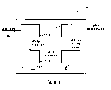
Fig. 1 shows a schematic block diagram of a device 10 for updating
cartographic data 12
for a predetennined region.
CA 02700228 2010-03-19
-6-
The device 10 includes means 14 for collecting location information 16 of a
path covered
in the predetermined region. The means 14 for collecting is coupled to a means
18 for
overlaying the collected location information with the cartographic data 12
for the
predetermined region. Furthermore, the device 10 includes means 20 for
determining
portions contradictory or niissing in the cartographic data 12 for the
predetermined region
on the basis of the overlaid, collected location information. Coupled to the
means 20 for
determining, there is means 22 for updating the cartographic data 12 in the
missing or
contradictory portions on the basis of the overlaid, collected location
infonnation.
The functioning of the device 10 for updating the cartographic data 12, as
schematically
shown in Fig. 1, will be explained in greater detail in the following on the
basis of Figs.
2-12.
Fig. 2 shows a flowchart for illustrating the flow of a method of updating the
cartographic
data 12, according to an embodiment of the present invention.
In a first step, S20, the location information 16 is collected in the
predetermined region.
Various position finding and/or location technologies may form the basis here.
The
probably best-known system for location and/or navigation in the outdoor area
is satellite-
assisted GPS. For the location and/or navigation within buildings and/or in an
indoor area,
infrared systems, RFID systems or WLAN systems may be employed, for example.
At
present, GPS is available in a reliable manner for the outdoor area only. More
recent
extensions, such as highly sensitive receivers or A-GPS (assisted GPS), as it
is called,
represent attempts to make the technology usable also within buildings. A-GPS
here
combines the use of satellite-based GPS with the reception of so-called
assistance
information from cellular mobile networks. For location within buildings or
within a
relatively small, confined outside area, radio systems on the basis of the
WLAN standard
suggest themselves, for example. Here, a WLAN-based location determination
may, for
example, be realized by way of a kind of RF (radio frequency) fingerprint,
wherein a
corresponding radio receiver records electromagnetic properties of its
surroundings, such
as reception field strength level, wherein a relatively exact position to the
radio receiver
can be derived therefrom.
Provided that a (mobile) localizing subscriber device has map and reference
information
and measurement values of sensors, in particular, it can determine its own
position.
Without map and/or reference information, the measured values may, however, be
transmitted to a location means capable of determining the position of the
subscriber
device from the measured values. For the step S20 of collecting the location
information, it
CA 02700228 2010-03-19
-7-
is irrelevant which technology the position determination is based on and
whether it is
carried out in a local, central or any hybrid way. It is only relevant that
position finding is
continuous. This means that when connecting the position information, position
determination and maybe position output are executed in a generally cyclical
manner and
not triggered interactively by a user. Here, a frequency at which the position
information
16 is determined is sufficiently high, so as to be able to offer a subscriber
not too jumpy a
presentation and ensure functioning of embodiments of the present invention,
even at
higher speeds of movement.
As schematically shown in Fig. 3a, in the step S20 of collecting the location
information
16, i.e. in a step S21, a sequence of positions representing movement of a
subscriber-
specific device and/or a location unit is generated. Here, the generated
sequence is
supported at the determined and/or estimated locations.
Fig. 4 exemplarily shows two mobile subscriber devices 30, each associated
with a
subscriber i and i+l (i = 0,The subscriber devices 30 each send their
determined
position information 16 to the means 14 for collecting. That is, the means 14
for collecting
is coupled to transceivers of the mobile subscriber devices 30, according to
embodiments.
The subscriber-specific location information 16 includes, for a measurement
time instant
Tn (n = 0,1,2,...,N), location coordinates x; (tõ), y; (tõ) and maybe z; (tõ)
corresponding to
height for three-dimensional representation. Furthermore, the location
information 16
includes time information on the respective measurement time instant tõ (n =
0,1,2,...,N)
and a transceiver tag of the respective subscriber device 30. A temporal
lineup of the
location information [(x; (to), y; (to)), ..., (xi (tN), yi (tN))] and/or
[xi.n (to), yi.a (tN), yi+1
(tN))] corresponds to a path 40, 42 covered by the respective subscriber in a
predeterniined
location region 44. The typical cartographic representations concem a two-
dimensional
region in the predetermined location region 44. Yet, applications of the
present invention
for three-dimensional location regions are also possible, of course.
The location information 16 generated by the mobile subscribers and/or their
terminal
devices 30 thus are present as a sequence of coordinates [(xi (to), y; (to)),
..., (x; (tN), yi
(tN))] and/or [x;,4 (to), y;-q (to)), ... ,(x;.n (tN), yi.n (tN))] in the
means 14 for collecting,
according to embodiments.
With reference to Fig. 3a, the collected location information is suitably
represented and
normalized in a next sub-step S22. Here, the collected location information
may, for
example, be represented as position sequences or chains of vectors.
CA 02700228 2010-03-19
-8-
As illustrated in Fig. 5a, the location infonnation 16, which originates from
a subscriber i
and/or the terminal device 30 thereof, is present as a sequence 50 of
coordinates [(xi(to),
yi(to)), ...,(x;(tN), y;(tN))] after the sub-step S21. One way is to directly
use this sequence
50 in order to identify popular, passable and reliably detected regions by way
of a detection
of position accumulations. In later views, however, a directional and temporal
reference
might be lost here, so that sequential modeling seems to make more sense for
embodiments
of the present invention. In this respect, a traverse 52 containing the
determined positions
[(x;(to), y;(to)), ...,(x;(tN), y;(tN))] in a global and/or local coordinate
system as support
points is illustrated in Fig. 5a. Supplementation of the non-defined regions
between the
positions [(x;(to), y;(to)), ...,(x;(tN), y;(tN))] by a connection of the
positions by means of
straight-line portions is characteristic. This procedure is suitable for
complete histories of
location information, but may also be performed for temporally and spatially
limited
regions.
Apart from this simple piece-wise interpolation by means of a traverse 52,
also
substantially more intensive methods can be used in embodiments of the present
invention,
to provide a continuous function describing a path covered from the discretely
existing
positional values [(x;(to), yi(to)), ...,(x;(tN), y;(tN))]. Various
mathematical approaches of
different degrees can be applied, which are labeled exemplarily by reference
numeral 54 in
Fig. 5b. This higher-degree representation allows for, beyond numerical
analyses,
functional comparison with respect to grouping and similarity analysis. Loops
in paths
covered can be removed by way of conesponding detection in embodiments of the
present
invention.
In the sub-step S22, nonnalization of the collected location information might
still be
necessary so as to produce comparability between paths covered by a plurality
of different
subscribers with different subscriber devices. Such normalization may, for
example, take
place when the different subscriber devices are based on different location
technologies
and communicate their positional and/or temporal data, e.g., in different data
formats to the
means 14 for collecting. Furthermore, it is conceivable that geographical
position data
(longitude and latitude indications) have to be converted to pixel
coordinates. For example,
this is the case when the cartographic data 12 for the predetermined location
region are
present as digital image data. Normalization in the sub-step S22 increases
later
comparability of different paths covered.
Collecting, S20, includes an improvement of the reliability of the collected
location
information by removing technology-induced errors, for example, by means of
suitable
filters, in a further sub-step S23 (Fig. 3a), according to embodiments. To
this end, Fig. 6
CA 02700228 2010-03-19
-9-
shows a sequence 60 of location information representing a path covered of a
subscriber i.
Individual position data 62, 64, which do not represent an insignificant
deviation from an
assumed path 66 covered, are noticeable. In order to adapt the position
sequence 60 to the
assumed path 66 covered, the means 14 for collecting according to embodiments
includes,
e.g. a low-pass filter to smooth the position sequence 60 and, thus, adapt the
positions 62
and 64 assumed to be faulty to the actual or more likely positions.
In the sub-step S23, the collected location information may further be
assessed to classify
the paths covered depending on various criteria, such as reliability and
quality of the
respective location technology, reputation of the source, age, etc. To this
end, according to
embodiments, means 14 for collecting is adapted to provide the collected
location
information with reliability information.
In a further sub-step, S24, the collected, filtered and assessed location
information
corresponding to the paths covered is handed over to a location information
sequence
management unit. To this end, means 14 for collecting comprises a memory. In
embodiments, this may, for example, be a digital memory. Here, the collected,
filtered and
assessed location information is collected with respect to comparability and
access
possibilities and managed in an optimized manner. From the (digital) memory,
forwarding
takes place for the evaluation of the plurality of ways and/or paths covered,
beyond
separate consideration of individual paths covered.
After collecting S20 the location information 16 in the predetermined region
with respect
to Fig. 2, overlaying S30 the collected location information with the
cartographic data 12
for the predetermined region follows. In a next step S40, there follows
determining
portions contradictory or missing in the cartographic data 12 for the
predeterniined region
on the basis of the overlaid, collected location information.
An exemplarily flow chart for a combination of steps S30 and S40 is shown
schematically
in Fig. 3b.
The location information collected and pre-processed in step S20 is present in
a kind of
raw form in the (digital) memory in which form it may be mapped to a known
and/or
predetermined region in a sub-step S32. To this end, means 14 for collecting,
according to
embodiments, is adapted to scale coordinates of the collected location
information 16 to
the scale of the cartographic data of the predetermined region. Furthermore,
in sub-step
S32, according to embodiments of the present invention, parts of paths covered
and/or
paths in regions known to be passable or trafficable can be taken out of
further
CA 02700228 2010-03-19
-10-
consideration. Of course, the location information corresponding to regions
known in the
cartographic data 12 can be processed further, which then serves for updating,
assessment
or enhancement of known data, rather than detailing or supplementing. Sub-step
S23 shall
be explained in greater detail in the following on the basis of Fig. 7.
Fig. 7 shows known cartographic data 12 for a predetermined region with a
plurality of
location and/or path information 82, 84, 86 mapped to the cartographic data
12. The path
information 82, 84 is mapped entirely to portions (e.g. streets or footpaths)
known already.
Parts of further path information 86 are in conflict with the existing
cartographic data 12
by reaching into portions of the cartographic data 12 previously labeled as
not passable
and/or trafficable. In sub-step S32, the path information 82, 84 mapped to the
known
portions of the cartographic data 12 and the corresponding known parts of the
path
information 86 are not considered any further. That is, these known path
segments can be
neglected for further consideration for reasons of efficiency. Only the parts
of the path
information 86 circled in Fig. 7 are considered. According to embodiments,
means 18 for
overlaying thus is adapted to link the location information corresponding to
the paths
covered with the cartographic data 12 such that known portions in the location
information
corresponding to the paths covered remain unconsidered in the cartographic
data 12.
If those path segments to be associated with portions missing in the
cartographic data 12 or
being contradictory have been determined in step S32, these path segments can
be
projected onto the corresponding portions of the cartographic data 12 in a
next sub-step,
S34, according to embodiments. To this end, the path segments may, for
example, be
weighted depending on an assessment performed in sub-step S23 and represented,
e.g. as
pixel matrices (with and without scattering) or (approximation) functions.
Possible
embodiments for the weighting will be explained in greater detail in the
following on the
basis of Figs. 8-11.
Fig. 8 shows two path segments 90, 92 weighted depending on selectable
criteria, such as
their reliabilities. In the scenario exemplarily shown in Fig. 8, the path 90
covered was
determined with a less reliable location technology than the path 92 covered.
Hence, the
path 90 covered is imparted with a first location unsharpness function, which
leads to a
projection of the path 90 covered to the corresponding map portions, which
make the path
90 covered appear with a certain width bl in an unsharpness corridor. In
contrast thereto,
the path 92 covered, which was recorded with the more accurate location
technology, is
provided with a second location unsharpness function, so that it is
represented by a width
b2 on the corresponding map portions in a less wide unsharpness corridor.
CA 02700228 2010-03-19
-11-
According to embodiments, means 18 for overlaying thus is adapted to weight
the location
infonnation con,:esponding to the paths covered corresponding to its accuracy
and/or
reliability with a location unsharpness function, in order to obtain a
location probability
statement. The projections of the paths covered to the respective map portions
may lead to
an intended overlay of the paths, particularly in regions corresponding, in
reality, to a path
covered.
Further embodiments for weighting location information corresponding to paths
covered
are shown in Fig. 9.
Depending on the original representation of the collected location information
and an
analysis algorithm, suitable weightings and/or scatterings may be used. Fig. 9
shows
possible saturation and/or weighting profiles of the projected position point
or position
path.
In the saturation profile designated with reference numeral 100, a point
[(xi(tõ), yi(tn))] or
path [(xi(to), y;(to)), ...,(xi(tN), yi(tN))] with maximum saturation is
depicted exactly at its
location without scattering, as also illustrated in Fig. 10 at reference
numeral 100. In the
saturation profile designated with reference numeral 102 in Fig. 9, a point
[(xi(tõ), yi(tõ))] is
represented with a sharply drawn circle with the original position as a
center, and a path
[(xi(to), y;(to)), ...,(x;(tN), yi(tN))] correspondingly with a certain width,
as also depicted
with the reference numeral 102 in Fig. 10. A parabolic saturation
characteristic designated
by the reference numeral 104 in Figs. 9 and 11 makes clear a higher weighting
of measured
positions with respect to a constructed scattering. A characteristic
designated by reference
numeral 106 in Figs. 9 and 11 links the previously-mentioned characteristics,
wherein a
scattering does not possess any sharp boundaries, a plateau-like region takes
influence with
reduced saturation, and measured values are prominent as fully saturated
points and/or
lines from the scattering via a peak.
Apart from the previously described characteristics, further forms are
possible, of course,
such as triangles or trapezoids. One reason for the introduction of a
scattering, for example,
is closing holes between neighboring paths covered and intercepting
inaccuracies, which
may develop in a system-induced manner in the location. A maximum saturation
level may
additionally be changed, e.g. depending on a location reliability or the
velocity. Thus, all
available points and/or paths in a map portion may be depicted in accordance
with this
scheme for analysis. Thereupon, frequently used regions may be identified from
an
overlay.
CA 02700228 2010-03-19
-12-
After the weighting and projection of the location information onto
corresponding map
portions in sub-step S34, there follows a similarity analysis in a next sub-
step, S36,
according to embodiments, wherein spatially neighboring path segments of
similar profile
are detected by comparing a plurality of paths covered to each other. To this
end, means 20
for determining according to embodiments is adapted to determine similar paths
deviating
from each other by a maximum tolerance range admissible from collected
location
information corresponding to a plurality of paths covered. The analysis may be
performed
in various ways. A first possibility is based on the projection S34 of the
location
information and ensuing graphical assessment. A plurality of location
information
corresponding to a plurality of paths covered in a certain map portion are
overlaid
additively, so that a replica of a complete movement history available is
obtained in the
map portion. Graded scattering characteristics, in particular, lend themselves
here. Holes
developing in the case of a simple line illustration thus are closed and
neighborhood
relations established between paths by way of the overlay, as shown in Fig.
12a.
Contiguous regions may now be determined by way of graphical edge detection,
wherein a
recognition threshold may be adjusted with respect to the saturation (Fig.
12b). Preferably,
the edges thus detected may, again, be modeled, e.g. as traverses or polygons,
as shown in
Fig. 12c. This way, holes between neighboring paths can be removed and edges
smoothed.
The number of paths included, the average saturation, or the distance between
the included
paths, e.g., may exert some influence on relevance and further processing.
Column-wise consideration is also possible. Here, calculation is done with the
points of the
paths at a defined section, and the distances among each other are determined.
The sections
may here take place in various ways, such as paraxially or orthogonally with
respect to a
reference path. The distances may then quantify a similarity and proximity of
paths per
section or as a sum, so that path groupings can be derived therefrom.
A further possibility is mathematical analysis. The conversion of location
coordinates via
simple traverses up to more complex interpolations as already described may
serve as a
basis here. So as to be able to determine similarities and proximities of
paths, different
computations may be used. On the basis of continuous functions, e.g. integrals
or slopes,
absolute values, correlations or even spectral behavior may be examined. This
may take
place on a global or a temporarily defined, local coordinate system.
Figs. 12d-12f show how similarities and proximities can be specified and
adjusted via
different parameterizations. In Fig. 12d, saturation threshold values are
adjusted such that
only very closely adjacent paths covered are classified into one group,
whereas the
CA 02700228 2010-03-19
-13-
saturation threshold values for grouping in Fig. 12e are adjusted such that
even more
distantly adjacent paths covered belong to a common group of paths. Saturation
threshold
values may, for example, be adjusted depending on velocity. Here, a velocity
with which a
path was covered can be determined easily from the time stamps for the
respective location
coordinates. Means 20 for determining is adapted, according to embodiments of
the present
invention, to determine similar paths deviating from each other by a maximum
tolerance
range admissible, which is determined by the saturation threshold values, from
collected
location information corresponding to a plurality of paths covered.
Outliers, which may develop e.g. through errors in the location or produced by
users
having left common paths, can be filtered out by way of the parameterization.
Following the analysis and grouping of the location information of the paths
covered, a
sub-step S38 for assessing and classifying the overlaid, collected location
information is
particularly important for later deciding on a type of feeding the updated
cartographic data
12 into a database. In embodiments of the present invention, with reference to
Fig. 3b, a
cartographic database is used already at the beginning of the location
information analysis,
which may be summarized by steps S30 and S40, in order to associate the
location
information with model and/or cartographic data 12 stored in the cartographic
database.
That is, in steps S30 and S40, the contradictory and/or missing map portions
are already
identified, and it is thus known at which locations, both geographically and
also logically,
changes and/or updates must be incorporated in the cartographic data 12. The
classification
in sub-step S38 serves to choose the representation matching the data format
and change.
Here, for example, depending on a width of a path covered and/or a width of a
group of
neighboring paths covered and/or the velocities at which the paths were
covered each, it
may be concluded whether a new region is a footpath, cycling path or a street.
That is,
means 20 for determining is adapted to extract path width and/or path velocity
information
from the location information and perform classification of the collected
location
information based thereon. Here, the width of a new path is defined, for
example, by a
constant distance from the path corresponding to a path covered or a middle
path of paths
covered. Numerous further possibilities may be applied, for example, such as a
region
definition about a maximum expanse of the detected, usable area by way of a
polygon.
Following steps S30, S40, integration of the information acquired therefrom
into the
existing cartographic data 12 is necessary. To this end, with reference to
Fig. 2, the method
of updating the cartographic data 12 includes a step S50 of updating the
cartographic data
12 in the missing or contradictory portions on the basis of the overlaid
collected location
information.
CA 02700228 2010-03-19
-14-
With reference to Fig. 3c, step S50 of updating includes a sub-step S52,
wherein the new
cartographic regions previously classified in the sub-step S38 are suitably
represented and
dimensioned. In other words, this means that a region classified as a cycling
path, for
example, is also represented as a cycling path and is also suitably
dimensioned. That is, a
cycling path will be generally less wide than a multi-lane street with heavy
traffic.
Representation and dimensioning are followed by a further sub-step, S54,
wherein the
represented and dimensioned location information is finally labeled
correspondingly, for
example, logically or graphically, e.g. by color, metadata or other
characters, and is fmally
integrated into the cartographic database to obtain an updated version of the
cartographic
data 12 on the basis of the previously overlaid and collected location
information.
In embodiments of the present invention, an update of the cartographic data 12
takes place
only when an update criterion, such as a minimum number of similar paths
corresponding
to path information not contained in the cartographic data 12, is met. In
other words, this
means that few similar paths covered may not be sufficient to perform an
update, because
the few similar paths covered do not yet really guarantee e.g. an actually
existing street or
the like.
In the following, the inventive concept shall again be illustrated on the
basis of Fig. 11.
Fig. 1 l a shows cartographic data 12 in the form of an aerial photograph for
a
predetermined region around a storage building. Fig. llb shows collected
location
information on paths covered in the predetermined region around the storage
building.
Here, Fig. l lb only exemplarily shows some, like the two paths 120, 122, each
weighted
according to one of the patterns described previously. It can be seen that
huge areas of the
two paths 120, 122 covered overlap. Fig. 11c shows the overlay of the paths
covered with
the cartographic data 12 for the predetermined region around the storage
building. It can be
seen therein that a part of the paths 120, 122 covered corresponds to a path
on a street,
whereas the remaining parts of the paths 120, 122 covered are on the storage
premises.
Fig. l ld shows an illustration of the paths 120, 122 covered, wherein a
boundary of the
region detected through grouping of the paths 120, 122 is illustrated. The new
region
detected in Fig. 11d, for which further information in the cartographic
material is niissing,
is illustrated as projected onto the photograph in Fig. 11e.
In sub-step S38, which concerns the assessment and classification of the
detected region,
siniilar regions in the cartographic data 12 may now be searched for, e.g. in
digital
CA 02700228 2010-03-19
-15-
photographs, i.e. regions having the same shade of color as the detected
region, for
example. To this end, means 20 for determining is adapted to determine a
passable and/or
trafficable area in the predetermined region from the location information and
surface
condition information from the cartographic data 12. In the example shown in
Fig. 11, this
leads to an expansion of the detected region by additional asphalt areas on
the street and
the storage premises. Since there are additional areas in the digital
photograph of the same
surface condition and/or shade of color as the detected region, one can assume
that the
additional regions may also be classified as passable and/or trafficable.
Thereby, the
hatched region depicted in Fig. Ilf develops, which can be labeled as passable
and/or
trafficable in the cartographic data 12 and integrated.
The inventive concept presented previously may be used for achieving various
objectives.
One obvious example is an update of existing cartographic material, which
means that
information that is already available is verified. This is done by means of an
implicit check
by subscribers and the inclusion of changes at run-time. Moreover, the
cartographic
material may continuously be refined further by perfonning supplementations.
In
particular, this relates to regions the usage of which is unknown or
inaccurate. Changes in
reality, e.g. through construction activity, are also introduced into the
cartographic material
via adaptive user behavior. Maximum value-added can be obtained when the data
thus
processed can be utilized by location technology and behavioral history in
order to produce
cartographic material in a completely new way. In extreme cases, this means
that an area
of unknown usability is gradually supplemented by information. It may then,
again, be
made available to various location applications as a map and serve as starting
material
there. One example is the creation of building or landscape maps, without any
further
available constniction details. Paths, passages, corridors, rooms, etc. can be
identified in
such a manner.
A further aspect is the matching of movement history and derived usage
classification with
pixel-based data, usually photographically generated image information. This
means that
the experience-based location information is combined with e.g. aerial or
satellite pictures
(in arbitrary frequency ranges). In such a photo or pixel matching, the two
information
levels, image and location information, are overlaid and then matched. Thus,
on the basis
of the photographs, e.g. boundary regions of analytically determined regions
can be
specified. Furthermore, errors may also be identified and removed from colors,
color
transitions and textures. Likewise, estimation of potentially usable regions
for which there
no position history is available yet is also possible. This is done via the
similarity to the
already linked (matched) regions.
CA 02700228 2010-03-19
-16-
In summary, on the basis of Fig. 13, the employment of the inventive concept
in a
navigation and/or location system shall be illustrated once again.
Position sequences [(xi(to), yi(to)), ...,(x;(tN), y;(tH))] are generated by
mobile subscribers
and/or their associated location units 140 by means of measurement and sensor
technology
142. The temporal and spatial reference of the positions of the position
sequences with
respect to each other and between these dimensions (time, space) allows for
representing
the respective paths covered. These paths covered are collected by the device
10 and
processed further so as to link them with existing information on the
surroundings from a
database 144. Here, the database 144 may be fed and/or updated with external
data 146 in
advance or additionally. In the device 10, e.g. rendition, maybe a
normalization of
geographical and temporal kind, evaluation with respect to source and quality
of the
collected location information, and maybe further steps take place, depending
on the
embodiment of the present invention. Furthermore, the location information
thus collected
is analyzed by grouping and identifying typical paths covered with a certain
parameterization. Influential quantities here are, e.g., number, velocity,
direction and/or
path profile, location technology, spatial and temporal distance. Thus, paths
covered in a
region can be recognized and labeled in an adjustable way within certain
boundaries and
sharpnesses, whereupon classification may take place, which classifies the
determined
character with respect to the repercussion on the cartographic material of the
database 144.
The previously mentioned evaluation serves as a basis for representing the
newly acquired
information in various ways in the database 144. For example, it may thus be
determined
whether a street of a certain basic extension or a footpath is modeled as an
unstructured,
passable area. The reliability of the new data may also be retained and serve
as indication
of the origin for further processing.
The entire approach becomes particularly relevant when regarded as a self-
learning
method, i.e. runs cyclically and evaluates automatically, and incorporates
according to the
above-described procedure, any new information provided from mobile units.
Embodiments of the present invention utilize the behavior of users. This means
that people
or vehicles generally use passable or trafficable areas. In vehicle
navigation, for example,
determined positions are projected onto the most probable street in the
proximity, even in
the case of slight deviations (so-called Map Matching). This increases the
calmness and
trustworthiness of the visualization. If it is assumed, in reverse, that a
large part of the
mobile users avoid obstacles and follow given and/or prescribed paths,
information on
these paths covered can be coupled to the cartographic material by embodiments
of the
present invention. In addition, unknown or changed paths can also be detected
with
CA 02700228 2010-03-19
-17-
embodiments of the present invention, with no information in this respect
having been
present previously. One example is a footpath through a park that is usually
used by a large
part of the people moving about there, but usually not deposited in
cartographic databases.
In particular, it is pointed out that, depending on the circumstances, the
inventive scheme
may also be implemented in software. The implementation may be on a digital
storage
medium, particularly a disk or CD with electronically readable control signals
capable of
co-operating with a programmable computer system and/or microcontroller so
that the
corresponding method is executed. In general, the invention thus also consists
in a
computer program product with a program code stored on a machine-readable
carrier for
performing the inventive method of updating cartographic data, when the
computer
program product is executed on a computer and/or microcontroller. In other
words, the
invention may thus be realized as a computer program with a program code for
performing
the method of updating cartographic data, when the computer program is
executed on a
computer and/or microcontroller.
Furthermore, it is pointed out that the present invention is not liniited to
the respective
components of the device 10 or the explained procedure, for these components
and
methods may vary. The tenms used here are only intended for describing
particular
embodiments and are not used in a limiting sense. When using the singular or
indefinite
articles in the description and in the claims, these also refer to the
plurality of these
elements unless clearly dictated otherwise by the overall context. The same
applies vice-
versa.