Note: Descriptions are shown in the official language in which they were submitted.
CA 02700535 2011-11-09
50866-90
SYSTEM AND METHOD FOR PERFORMING OILFIELD
OPERATIONS
100011
BACKGROUND OF THE INVENTION
Field of the Invention
100021 The present invention relates to techniques for performing oilfield
operations relating to subterranean formations having reservoirs therein.
More particularly, the invention relates to techniques for performing oilfield
operations involving an analysis of oilfield conditions, such as geological,
geophysical and reservoir engineering characteristics, and their impact on
such operations.
Background of the Related Art
[0003] Oilfield operations, such as surveying, drilling; wireline testing,
completions, production, planning and oilfield analysis, are typically
performed to locate and gather valuable downhole fluids. Various aspects of
the oilfield and its related operations are shown in FIGS. IA-1D. As shown.
in FIG. IA, surveys are often performed using acquisition methodologies,
such as seismic scanners or surveyors to generate maps of underground
formations. These formations are often analyzed to determine the presence
of subterranean assets, such as valuable fluids or minerals. This information
is used to assess the underground formations and locate the formations
containing the desired subterranean assets. This information may also be
used to determine whether the formations have characteristics suitable for
storing fluids. Data collected from the acquisition methodologies may be
evaluated and analyzed to determine whether such valuable assets are
present, and if they are reasonably accessible.
1
CA 02700535 2010-03-23
WO 2009/045870 PCT/US2008/077778
[0004] As shown in FIGS. 1 B-1 D, one or more wellsites may be positioned
along the underground formations to gather valuable fluids from the
subterranean reservoirs. The wellsites are provided with tools capable of
locating and removing hydrocarbons, such as oil or gas, from the
subterranean reservoirs. As shown in FIG. 1B, drilling tools are typically
deployed from the oil and gas rigs and advanced into the earth along a path
to locate reservoirs containing the valuable downhole assets. Fluid, such as
drilling mud or other drilling fluids, is pumped down the wellbore through
the drilling tool and out the drilling bit. The drilling fluid flows through
the
annulus between the drilling tool and the wellbore and out the surface,
carrying away earth loosened during drilling. The drilling fluids return the
earth to the surface, and seals the wall of the wellbore to prevent fluid in
the
surrounding earth from entering the wellbore and causing a `blow out.'
[0005] During the drilling operation, the drilling tool may perform downhole
measurements to investigate downhole conditions. The drilling tool may be
used to take core samples of the subsurface formations. In some cases, as
shown in FIG. 1 C, the drilling tool is removed and a wireline tool is
deployed into the wellbore to perform additional downhole testing, such as
logging or sampling. Steel casing may be run into the well to a desired
depth and cemented into place along the wellbore wall. Drilling may be
continued until the desired total depth is reached.
[0006] After the drilling operation is complete, the well may then be prepared
for production. As shown in FIG. 1D, wellbore completions equipment is
deployed into the wellbore to complete the well in preparation for the
production of fluid therethrough. Fluid is then allowed to flow from
downhole reservoirs, into the wellbore and to the surface. Production
facilities are positioned at surface locations to collect the hydrocarbons
from
the wellsite(s). Fluid drawn from the subterranean reservoir(s) passes to the
production facilities via transport mechanisms, such as tubing. Various
equipments may be positioned about the oilfield to monitor oilfield
2
CA 02700535 2010-03-23
WO 2009/045870 PCT/US2008/077778
parameters, to manipulate the oilfield operations and/or to separate and
direct fluids from the wells. Surface equipment and completion equipment
may also be used to inject fluids into reservoirs, either for storage or at
strategic points to enhance production of the reservoir.
[0007] During the oilfield operations, data is typically collected for
analysis
and/or monitoring of the oilfield operations. Such data may include, for
example, subterranean formation, equipment, historical and/or other data.
Data concerning the subterranean formation is collected using a variety of
sources. Such formation data may be static or dynamic. Static data relates
to, for example, formation structure and geological stratigraphy that define
geological structures of the subterranean formation. Dynamic data relates
to, for example, fluids flowing through the geologic structures of the
subterranean formation over time. Such static and/or dynamic data may be
collected to learn more about the formations and the valuable assets
contained therein.
[0008] Sources used to collect static data may be seismic tools, such as a
seismic truck that sends compression waves into the earth as shown in FIG.
IA. Signals from these waves are processed and interpreted to characterize
changes in the anisotropic and/or elastic properties, such as velocity and
density, of the geological formation at various depths. This information may
be used to generate basic structural maps of the subterranean formation.
Other static measurements may be gathered using downhole measurements,
such as core sampling and well logging techniques. Core samples are used
to take physical specimens of the formation at various depths as shown in
FIG. 1B. Well logging involves deployment of a downhole tool into the
wellbore to collect various downhole measurements, such as density,
resistivity, etc., at various depths. Such well logging may be performed
using, for example, the drilling tool of FIG. I B and/or the wireline tool of
FIG. I C. Once the well is formed and completed, fluid flows to the surface
using production tubing and other completion equipment as shown in FIG.
3
CA 02700535 2010-03-23
WO 2009/045870 PCT/US2008/077778
1D. As fluid passes to the surface, various dynamic measurements, such as
fluid flow rates, pressure and composition may be monitored. These
parameters may be used to determine various characteristics of the
subterranean formation.
[0009] Sensors may be positioned about the oilfield to collect data relating
to
various oilfield operations. For example, sensors in the drilling equipment
may monitor drilling conditions, sensors in the wellbore may monitor fluid
composition, sensors located along the flow path may monitor flow rates and
sensors at the processing facility may monitor fluids collected. Other
sensors may be provided to monitor downhole, surface, equipment or other
conditions. Such conditions may relate to the type of equipment at the
wellsite, the operating setup, formation parameters or other variables of the
oilfield. The monitored data is often used to make decisions at various
locations of the oilfield at various times. Data collected by these sensors
may be further analyzed and processed. Data may be collected and used for
current or future operations. When used for future operations at the same or
other locations, such data may sometimes be referred to as historical data.
[0010] The data may be used to predict downhole conditions, and make
decisions concerning oilfield operations. Such decisions may involve well
planning, well targeting, well completions, operating levels, production rates
and other operations and/or operating parameters. Often this information is
used to determine when to drill new wells, re-complete existing wells or
alter wellbore production. Oilfield conditions, such as geological,
geophysical and reservoir engineering characteristics, may have an impact
on oilfield operations, such as risk analysis, economic valuation, and
mechanical considerations for the production of subsurface reservoirs.
[0011] Data from one or more wellbores may be analyzed to plan or predict
various outcomes at a given wellbore. In some cases, the data from
neighboring wellbores, or wellbores with similar conditions or equipment
may be used to predict how a well will perform. There are usually a large
4
CA 02700535 2010-03-23
WO 2009/045870 PCT/US2008/077778
number of variables and large quantities of data to consider in analyzing
oilfield operations. It is, therefore, often useful to model the behavior of
the
oilfield operation to determine a desired course of action. During the
ongoing operations, the operating parameters may need adjustment as
oilfield conditions change and new information is received.
[0012] Techniques have been developed to model the behavior of geological
formations, downhole reservoirs, wellbores, surface facilities as well as
other portions of the oilfield operation. Examples of these modeling
techniques are shown in Patent/Publication/Application Nos. US5992519,
W02004/049216, W01999/064896, US6313837, US2003/0216897,
US7248259, US2005/0149307 and US2006/0197759. Typically, existing
modeling techniques have been used to analyze only specific portions of the
oilfield operations. More recently, attempts have been made to use more
than one model in analyzing certain oilfield operations. See, for example,
Patent/Publication/Application Nos. US6980940, W02004/049216,
US2004/0220846 and 10/586,283. Additionally, techniques for modeling
certain aspects of an oilfield have been developed , such as
OPENWORKSTM with, e.g., SEISWORKSTM, STRATWORKSTM,
GEOPROBETM or ARIESTM by LANDMARKTM (see www.lgc.com);
VOXELGEOTM, GEOLOGTM and STRATIMAGICTM by PARADIGMTM
(see www.paradigmgeo.com); 3EWELSUITETM by JOATM (see
www jewelsuite.com); RMSTM products by ROXARTM (see
www.roxar.com), and PETRELTM by SCHLUMBERGERTM (see
www.slb.com/content/services/software/index.asp? )-
[00131 Despite the development and advancement of various aspects of
oilfield analysis, there remains a need to provide techniques capable of
performing a complex analysis of oilfield operations based on a wide variety
of parameters affecting such operations. It is desirable that such a complex
analysis provide a unified view of selective portions of the oilfield
operation,
such as geological, geophysical, reservoir engineering, drilling, production
CA 02700535 2010-03-23
WO 2009/045870 PCT/US2008/077778
engineering, economic and/or other aspects of the oilfield. This unified
view may be used to view, analyze and/or understand the co-dependencies
of the individual portion(s) of the oilfield operations and the interaction
therebetween. Such a system would preferably permit consideration of a
wider variety and/or quantity of data affecting the oilfield to generate a
common understanding of current and/or future conditions of the oilfield by
selectively connecting desired modules throughout the oilfield. Preferably,
the provided techniques would be capable of one of more of the following,
among others: calibrating measurements from different scales (methods of
measurement and volume of influence for such measurements), efficiently
analyzing data from a wide variety of sources, generating static models
based on any known measurements, selectively modeling based on a variety
of inputs, selectively simulating according to dynamic inputs, adjusting
models based on probabilities, selectively connecting models of a variety of
functions (e.g. economic risk and viability), selectively performing feedback
loops throughout the process, selectively storing and/or replaying various
portions of the process, selectively displaying and/or visualizing outputs
(e.g. displays, reports, etc.), selectively updating the models as new
measurements become available, providing the ability to numerically
simulate static and dynamic properties, providing the ability to perform
economic analysis throughout the modeling system, selectively performing
desired modeling (e.g. uncertainty modeling), providing workflow
knowledge capture, enabling scenario planning and testing, providing
reserves reporting with associated audit trail reporting, dynamically
connecting selective models in an application and generating a surface
model from selected oilfield modules.
SUMMARY OF THE INVENTION
[00141 In at least one aspect, the invention relates to a system for
performing
oilfield operations for an oilfield, the oilfield having a subterranean
formation with geological structures and reservoirs therein. The system is
6
CA 02700535 2010-03-23
WO 2009/045870 PCT/US2008/077778
provided with a plurality of oilfield modules positioned in an application,
and a connection between each of the plurality of oilfield modules. Each of
the oilfield modules models at least a portion of the oilfield. At least one
of
the connections is a dynamic connection providing knowledge sharing for
unified modeling therebetween whereby at least one oilfield model is
generated.
[0015] In another aspect, the invention relates to a system for performing
oilfield operations for an oilfield, the oilfield having a subterranean
formation with geological structures and reservoirs therein. The system
provided with a plurality of oilfield modules for modeling at least a portion
of the oilfield, at least one internal database positioned in the application
and
operatively connected to at least one of the plurality of oilfield modules and
at least one connection between each of the plurality of oilfield modules.
The oilfield modules are positioned in an application. At least one of the
connections is an integrated connection providing cooperation for integrated
modeling therebetween whereby at least one oilfield model is generated.
[0015] In yet another aspect, the invention relates to a method of performing
oilfield operations for an oilfield, the oilfield having a subterranean
formation with geological structures and reservoirs therein. The method
involves collecting oilfield data, positioning a plurality of oilfield modules
in an application, selectively connecting at least a portion of the plurality
of
oilfield modules via a dynamic connection for knowledge sharing
therebetween and generating at least one oilfield model using the oilfield
data and the plurality of oilfield modules.
[0017] Finally, in another aspect, the invention relates to a method of
performing oilfield operations for an oilfield, the oilfield having a
subterranean formation with geological structures and reservoirs therein.
The method involves collecting oilfield data in a database positioned in an
application, positioning a plurality of oilfield modules in the application,
selectively connecting at least a portion of the plurality of oilfield modules
7
CA 02700535 2010-03-23
WO 2009/045870 PCT/US2008/077778
via an integrated connection providing cooperation therebetween, and
generating at least one oilfield model using the oilfield data and the
plurality
of oilfield modules.
[0018] Other aspects of the invention may be determined from the description
herein.
BRIEF DESCRIPTION OF THE DRAWINGS
[00191 So that the above described features and advantages of the present
invention can be understood in detail, a more particular description of the
invention, briefly summarized above, may be had by reference to the
embodiments thereof that are illustrated in the appended drawings. It is to be
noted, however, that the appended drawings illustrate only typical
embodiments of this invention and are therefore not to be considered
limiting of its scope, for the invention may admit to other equally effective
embodiments.
[0020] FIGS. IA-1D depict a simplified, schematic view of an oilfield having
subterranean formations containing reservoirs therein, the various oilfield
operations being performed on the oilfield. FIG. 1 A depicts a survey
operation being performed by a seismic truck. FIG. 113 depicts a drilling
operation being performed by a drilling tool suspended by a rig and
advanced into the subterranean formations. FIG. IC depicts a wireline
operation being performed by a wireline tool suspended by the rig and into
the wellbore of FIG. 113. FIG. ID depicts a production operation being
performed by a production tool being deployed from a production unit and
into the completed wellbore of FIG. I C for drawing fluid from the reservoirs
into surface facilities.
10021] FIGS. 2A-D are graphical depictions of data collected by the tools of
FIGS. IA-D, respectively. FIG. 2A depicts a seismic trace of the
subterranean formation of FIG. 1 A. FIG. 2B depicts a core test result of the
core sample of FIG. I B. FIG. 2C depicts a well log of the subterranean
8
CA 02700535 2010-03-23
WO 2009/045870 PCT/US2008/077778
formation of FIG. 1 C. FIG. 2D depicts a production decline curve of fluid
flowing through the subterranean formation of FIG. I D.
[0022] FIG. 3 is a schematic view, partially in cross section of an oilfield
having a plurality of data acquisition tools positioned at various locations
along the oilfield for collecting data from the subterranean formations.
[0023] FIGS. 4A-4C are schematic, 3D views of static models based on the
data acquired by the data acquisition tools of FIG. 3.
[0024] FIG. 5 is graphical representation of a probability plot of the static
models of FIG. 4.
[0025] FIGS. 6A-B are schematic diagrams depicting independent systems for
performing an oilfield operation. FIG. 6A depicts an independent database
system having a plurality of separate oilfield modules (with corresponding
separate applications) and a report generator, the modules connected to a
shared database for passing events to and from the shared database. FIG. 6B
depicts an independent process system with real-time functionality, the
independent process system having a plurality of separate oilfield modules
(with corresponding separate applications) for generating a combined earth
model, the modules connected to pass data and events in a uni-directional
flow therebetween.
[0026] FIGS. 7A-B are schematic diagrams depicting integrated systems for
performing an oilfield operation. FIG. 7A depicts a uni-directional
integrated system with economics capabilities, the uni-directional integrated
system having a plurality of oilfield modules positioned in the same
application, the modules generating a shared earth model. FIG. 7B depicts a
bi-directional integrated system with database functionality, the bi-
directional integrated system having a plurality of oilfield modules
positioned in the same application and generating at least one integrated
earth model.
[0027] FIGS. 8 depicts a unified system for performing an oilfield operation,
9
CA 02700535 2010-03-23
WO 2009/045870 PCT/US2008/077778
the unified system having a plurality of dynamically connected oilfield
modules generating a unified earth model, the unified system provided with
a shared database, oilfield inputs/outputs, an extension and an economics
layer.
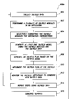
[0028] FIGS. 9A and 9B are flow charts depicting methods of performing
oilfield operations.
DETAILED DESCRIPTION
[0029] Presently preferred embodiments of the invention are shown in the
above-identified FIGS. and described in detail below. In describing the
preferred embodiments, like or identical reference numerals are used to
identify common or similar elements. The FIGS. are not necessarily to scale
and certain features and certain views of the FIGS. may be shown
exaggerated in scale or in schematic in the interest of clarity and
conciseness.
[0030] FIGS. IA-ID depict simplified, representative, schematic views of an
oilfield (100) having subterranean formation (102) containing reservoir
(104) therein and depicting various oilfield operations being performed on
the oilfield. FIG. IA depicts a survey operation being performed by a
survey tool, such as seismic truck (106a), to measure properties of the
subterranean formation. The survey operation is a seismic survey operation
for producing sound vibrations. In FIG. IA, one such sound vibration (112)
generated by a source (110) reflects off a plurality of horizons (114) in an
earth formation (116). The sound vibration(s) (112) is (are) received in by
sensors, such as geophone-receivers (118), situated on the earth's surface,
and the geophones (118) produce electrical output signals, referred to as data
received (120) in FIG. 1A.
[0031] . In response to the received sound vibration(s) (112) representative
of
different parameters (such as amplitude and/or frequency) of the sound
vibration(s) (112), the geophones (118) produce electrical output signals
CA 02700535 2010-03-23
WO 2009/045870 PCT/US2008/077778
containing data concerning the subterranean formation. The data received
(120) is provided as input data to a computer (122a) of the seismic truck
(106a), and responsive to the input data, the computer (122a) generates a
seismic data output (124). The seismic data output may be stored,
transmitted or further processed as desired, for example by data reduction.
[00321 FIG. 1B depicts a drilling operation being performed by a drilling
tools
(106b) suspended by a rig (128) and advanced into the subterranean
formations (102) to form a wellbore (136). A mud pit (130) is used to draw
drilling mud into the drilling tools via flow line (132) for circulating
drilling
mud through the drilling tools, up the wellbore (136) and back to the
surface. The drilling mud is usually filtered and returned to the mud pit. A
circulating system may be used for storing, controlling or filtering the
flowing drilling muds. The drilling tools are advanced into the subterranean
formations to reach reservoir (104). Each well may target one or more
reservoirs. The drilling tools are preferably adapted for measuring
downhole properties using logging while drilling tools. The logging while
drilling tool may also be adapted for taking a core sample (133) as shown, or
removed so that a core sample may be taken using another tool.
[0033] A surface unit (134) is used to communicate with the drilling tools
and/or offsite operations. The surface unit is capable of communicating with
the drilling tools to send commands to the drilling tools, and to receive data
therefrom. The surface unit is preferably provided with computer facilities
for receiving, storing, processing, and/or analyzing data from the oilfield.
The surface unit collects data generated during the drilling operation and
produces data output (135) which may be stored or transmitted. Computer
facilities, such as those of the surface unit, may be positioned at various
locations about the oilfield and/or at remote locations.
100341 Sensors (S), such as gauges, may be positioned about the oilfield to
collect data relating to various oilfield operations as described previously.
As shown, the sensor (S) is positioned in one or more locations in the
11
CA 02700535 2010-03-23
WO 2009/045870 PCT/US2008/077778
drilling tools and/or at the rig to measure drilling parameters, such as
weight
on bit, torque on bit, pressures, temperatures, flow rates, compositions,
rotary speed and/or other parameters of the oilfield operation. Sensors may
also be positioned in one or more locations in the circulating system.
[00351 The data gathered by the sensors may be collected by the surface unit
and/or other data collection sources for analysis or other processing. The
data collected by the sensors may be used alone or in combination with other
data. The data may be collected in one or more databases and/or transmitted
on or offsite. All or select portions of the data may be selectively used for
analyzing and/or predicting oilfield operations of the current and/or other
wellbores. The data may be may be historical data, real time data or
combinations thereof. The real time data may be used in real time, or stored
for later use. The data may also be combined with historical data or other
inputs for further analysis. The data may be stored in separate databases, or
combined into a single database.
[0036] The collected data may be used to perform analysis, such as modeling
operations. For example, the seismic data output may be used to perform
geological, geophysical, and/or reservoir engineering. The reservoir,
wellbore, surface and/or process data may be used to perform reservoir,
wellbore, geological, geophysical or other simulations. The data outputs
from the oilfield operation may be generated directly from the sensors, or
after some preprocessing or modeling. These data outputs may act as inputs
for further analysis.
[00371 The data may be collected and stored at the surface unit (134). One or
more surface units may be located at the oilfield, or connected remotely
thereto. The surface unit may be a single unit, or a complex network of
units used to perform the necessary data management functions throughout
the oilfield. The surface unit may be a manual or automatic system. The
surface unit may be operated and/or adjusted by a user.
[00381 The surface unit may be provided with a transceiver (137) to allow
12
CA 02700535 2010-03-23
WO 2009/045870 PCT/US2008/077778
communications between the surface unit and various portions of the oilfield
or other locations. The surface unit may also be provided with or
functionally connected to one or more controllers for actuating mechanisms
at the oilfield. The surface unit may then send command signals to the
oilfield in response to data received. The surface unit may receive
commands via the transceiver or may itself execute commands to the
controller. A processor may be provided to analyze the data (locally or
remotely), make the decisions and/or actuate the controller. In this manner,
the oilfield may be selectively adjusted based on the data collected. This
technique may be used to optimize portions of the oilfield operation, such as
controlling drilling, weight on bit, pump rates or other parameters. These
adjustments may be made automatically based on computer protocol, and/or
manually by an operator. In some cases, well plans may be adjusted to
select optimum operating conditions, or to avoid problems.
[0039] FIG. 1 C depicts a wireline operation being performed by a wireline
tool (106c) suspended by the rig (128) and into the wellbore (136) of FIG.
1B. The wireline tool is preferably adapted for deployment into a wellbore
for generating well logs, performing downhole tests and/or collecting
samples. The wireline tool may be used to provide another method and
apparatus for performing a seismic survey operation. The wireline tool of
FIG. 1C may, for example, have an explosive, radioactive, electrical, or
acoustic energy source (144) that sends and/or receives electrical signals to
the surrounding subterranean formations (102) and fluids therein.
[0040] The wireline tool may be operatively connected to, for example, the
geophones (118) and the computer (122a) of the seismic truck (106a) of
FIG. IA. The wireline tool may also provide data to the surface unit (134).
The surface unit collects data generated during the wireline operation and
produces data output (135) which may be stored or transmitted. The wireline
tool may be positioned at various depths in the wellbore to provide a survey
or other information relating to the subterranean formation.
13
CA 02700535 2010-03-23
WO 2009/045870 PCT/US2008/077778
[0041] Sensors (S), such as gauges, may be positioned about the oilfield to
collect data relating to various oilfield operations as described previously.
As shown, the sensor (S) is positioned in the wireline tool to measure
downhole parameters which relate to, for example porosity, permeability,
fluid composition and/or other parameters of the oilfield operation.
[0042] FIG. 1D depicts a production operation being performed by a
production tool (106d) deployed from a production unit or Christmas tree
(129) and into the completed wellbore (136) of FIG. 1C for drawing fluid
from the downhole reservoirs into surface facilities (142). Fluid flows from
reservoir (104) through perforations in the casing (not shown) and into the
production tool (106d) in the wellbore (136) and to the surface facilities
(142) via a gathering network (146).
[0043] Sensors S, such as gauges, may be positioned about the oilfield to
collect data relating to various oilfield operations as described previously.
As shown, the sensor S may be positioned in the production tool (106d) or
associated equipment, such as the Christmas tree, gathering network, surface
facilities and/or the production facility, to measure fluid parameters, such
as
fluid composition, flow rates, pressures, temperatures, and/or other
parameters of the production operation.
[0044] While only simplified wellsite configurations are shown, it will be
appreciated that the oilfield may cover a portion of land, sea and/or water
locations that hosts one or more wellsites. Production may also include
injection wells (not shown) for added recovery- One or more gathering
facilities may be operatively connected to one or more of the wellsites for
selectively collecting downhole fluids from the wellsite(s).
[0045] While FIGS. 1 B-D depict tools used to measure properties of an
oilfield, it will be appreciated that the tools may be used in connection with
non-oilfield operations, such as mines, aquifers, storage or other
subterranean facilities. Also, while certain data acquisition tools are
depicted, it will be appreciated that various measurement tools capable of
14
CA 02700535 2010-03-23
WO 2009/045870 PCT/US2008/077778
sensing parameters, such as seismic two-way travel time, density, resistivity,
production rate, etc., of the subterranean formation and/or its geological
formations may be used. Various sensors (S) may be located at various
positions along the wellbore and/or the monitoring tools to collect and/or
monitor the desired data. Other sources of data may also be provided from
offsite locations.
[0046] The oilfield configuration of FIGS. 1A-D is intended to provide a brief
description of an example of an oilfield usable with the present invention.
Part, or all, of the oilfield may be on land, water and/or sea. Also, while a
single oilfield measured at a single location is depicted, the present
invention
may be utilized with any combination of one or more oilfields, one or more
processing facilities and one or more wellsites.
[0047] FIGS. 2A-D are graphical depictions of examples of data collected by
the tools of FIGS. lA-D, respectively. FIG. 2A depicts a seismic trace (202)
of the subterranean formation of FIG. IA taken by seismic truck (106a).
The seismic trace may be used to provide data, such as a two-way response
over a period of time. FIG. 2B depicts a core sample (133) taken by the
drilling tools (106b). The core sample may be used to provide data, such as
a graph of the density, porosity, permeability or other physical property of
the core sample over the length of the core. Tests for density and viscosity
may be performed on the fluids in the core at varying pressures and
temperatures. FIG. 2C depicts a well log (204) of the subterranean
formation of FIG. 1 C taken by the wireline tool (106c). The wireline log
typically provides a resistivity or other measurement of the formation at
various depts. FIG. 2D depicts a production decline curve or graph (206) of
fluid flowing through the subterranean formation of FIG. 1 D measured at the
surface facilities (142). The production decline curve typically provides the
production rate Q as a function of time t.
[0048] The respective graphs of FIGS. 2A-2C depict examples of static
measurements that may describe or provide information about the physical
CA 02700535 2010-03-23
WO 2009/045870 PCT/US2008/077778
characteristics of the formation and reservoirs contained therein. These
measurements may be analyzed to better define the properties of the
formation(s) and/or determine the accuracy of the measurements and/or for
checking for errors. The plots of each of the respective measurements may
be aligned and scaled for comparison and verification of the properties.
100491 FIG. 2D depicts an example of a dynamic measurement of the fluid
properties through the wellbore. As the fluid flows through the wellbore,
measurements are taken of fluid properties, such as flow rates, pressures,
composition, etc. As described below, the static and dynamic measurements
may be analyzed and used to generate models of the subterranean formation
to determine characteristics thereof. Similar measurements may also be
used to measure changes in formation aspects over time.
[0050] FIG. 3 is a schematic view, partially in cross section of an oilfield
(300) having data acquisition tools (302a), (302b), (302c) and (302d)
positioned at various locations along the oilfield for collecting data of the
subterranean formation 304. The data acquisition tools (302a)-(302d) may
be the same as data acquisition tools (106a)-(106d) of FIGS. IA-D,
respectively, or others not depicted. As shown, the data acquisition tools
(302a)-(302d) generate data plots or measurements (308a)-(308d),
respectively. These data plots are depicted along the oilfield to demonstrate
the data generated by the various operations.
[0051] Data plots (308a)-(308c) are examples of static data plots that may be
generated by the data acquisition tools (302a)-(302d), respectively. Static
data plot (308a) is a seismic two-way response time and may be the same as
the seismic trace (202) of FIG. 2A. Static plot (308b) is core sample data
measured from a core sample of the formation (304), similar to core sample
(133) of FIG. 2B. Static data plot (308c) is a logging trace, similar to the
well log (204) of FIG. 2C. Production decline curve or graph (308d) is a
dynamic data plot of the fluid flow rate over time, similar to the graph (206)
of FIG. 2D. Other data may also be collected, such as historical data, user
16
CA 02700535 2010-03-23
WO 2009/045870 PCT/US2008/077778
inputs, economic information and/or other measurement data and other
parameters of interest.
[0052] The subterranean structure (304) has a plurality of geological
formations (306a)-(306d). As shown, the structure has several formations or
layers, including a shale layer (306a), a carbonate layer (306b), a shale
layer
(306c) and a sand layer (306d). A fault (307) extends through the layers
(306a), (306b). The static data acquisition tools are preferably adapted to
take measurements and detect characteristics of the formations.
[0053] While a specific subterranean formation with specific geological
structures are depicted, it will be appreciated that the oilfield may contain
a
variety of geological structures and/or formations, sometimes having
extreme complexity. In some locations, typically below the water line, fluid
may occupy pore spaces of the formations. Each of the measurement
devices may be used to measure properties of the formations and/or its
geological features. While each acquisition tool is shown as being in
specific locations in the oilfield, it will be appreciated that one or more
types
of measurement may be taken at one or more location across one or more
oilfields or other locations for comparison and/or analysis.
[0054] The data collected from various sources, such as the data acquisition
tools of FIG. 3, may then be processed and/or evaluated. Typically, seismic
data displayed in the static data plot (308a) from the data acquisition tool
(302a) is used by a geophysicist to determine characteristics of the
subterranean formations and features. Core data shown in static plot (308b)
and/or log data from the well log (308c) are typically used by a geologist to
determine various characteristics of the subterranean formation. Production
data from the graph (308d) is typically used by the reservoir engineer to
determine fluid flow reservoir characteristics. The data analyzed by the
geologist, geophysicist and the reservoir engineer may be analyzed using
modeling techniques. Examples of modeling techniques are described in
Patent/Publication/Application No. US5992519, W02004/049216,
17
CA 02700535 2011-11-09
50866-90
WO 1999/064896, US6313837, US2003/0216897, US7248259,
US2005/0149307 and US2006/0197759. Systems for performing such
modeling techniques are described, for example, in issued patent
US7248259.
[00551 FIGS. 4A-4C depict three-dimensional graphical representations of the
subsurface referred to as a static model. The static model may be generated
based on one or more of the models generated from, for example, the data
gathered using the data acquisition tools (302a)-(302d). In the figures
provided, the static models (402a)-(402c) are generated by the data
acquisition tools (302a)-(302c) of FIG- 3, respectively. These static models
may provide a bi-dimensional view of the subterranean formation (i.e., as an
earth model), based on the, data collected at the given location.
[00561 The static models may have different accuracies based on the types of
measurements available, quality of data, location and other factors. While
the static models of FIGS. 4A-4C are taken using certain data acquisition
tools at a single location of the oilfield, one or more of the same or
different
data acquisition tools may be used to take measurements at one or more
locations throughout the oilfield to generate a variety of models. Various
analysis and modeling techniques may be selected depending on the desired
data type and/or location.
100571 Each of the static models (402a-c) is depicted as volumetric
representations of an oilfield with one or more reservoirs, and their
surrounding formation structures. These volumetric representations are a
prediction of the geological structure of the subterranean formation at the
specified location based upon available measurements. Preferably, the
representations are probable scenarios, created using the same input data
(historical and/or real time), but having differing interpretation,
interpolation, and modeling techniques- As shown, the static models contain
geological layers within the subterranean formation. In particular fault (307)
18
CA 02700535 2010-03-23
WO 2009/045870 PCT/US2008/077778
of FIG. 3 extends through each of the models. Each static model also has
reference points A, B and C located at specific positions along each of the
static models. These static models and the specific reference points of the
static models may be analyzed. For example, a comparison of the different
static models may show differences in the structure of fault (307) and the
adjacent layer (306a). Each of the reference points may assist in the
comparison between the various static models. Adjustments may be made to
the models based on an analysis of the various static models in FIGS. 4A-C,
and an adjusted formation layer may be generated as will be described
further below.
100581 FIG. 5 depicts graphical representation of a probability plot of
multiple
static models, such as the models (402a)-(402c) of FIGS. 4A-4C. The graph
depicts a range of reservoir attribute value (V), such as volumetrics,
production rate, gross rock thickness, net pay, cumulative production,
etc. The value of the reservoir attribute (V) can vary due to any static or
dynamic component(s) being assessed, such as structure, porosity,
permeability, fluid contact levels, etc. The variables are typically
constrained in the modeling exercise to be within reasonable predictions of
what the real reservoir(s) are capable of, or what has been observed in
similar reservoirs. This graph is a histogram showing multiple model
realizations that may be generated by the provided data. The variable results
may be generated by varying multiple model parameters. The graph may
then be generated by reviewing and estimating the probability of the models
generated and plotting them.
[00591 As shown, all the model realizations that make up the distribution
graph are equally probable in geological terms. The histogram indicates that
static model (402a) provides a ninety percent probability of having at least
that amount of variable (V). The histogram as shown also indicates that
static model (402b) has a fifty percent probability of having at least that
amount of variable (V), and static model (402c) a ten percent probability of
19
CA 02700535 2010-03-23
WO 2009/045870 PCT/US2008/077778
having this higher amount. This graph suggests that static model (402c) is
the more optimistic model estimate of variable (V). The static models and
their associated likelihoods may be used, for example, in determining field
development plans and surface facility production schemes. Combinations
of static model representations, for example (402a) through (402c), are
considered and analyzed to assess the risk and/or economic tolerance of field
development plans.
100601 Referring back to the static models of FIGS. 4A-4C, the models have
been adjusted based on the dynamic data provided in the production of the
graph (308d) of FIG. 3. The dynamic data either collected by data
acquisition tool or predicted using modeling techniques, (302d) is applied to
each of the static models (402a)-(402c). As shown, the dynamic data
indicates that the fault (307) and layer (306a) as predicted by the static
models may need adjustment. The layer (306a) has been adjusted in each
model as shown by the dotted lines. The modified layer is depicted as
(306a'), (306a") and (306a"') for the static models of FIGS. 4A-4C,
respectively.
100611 The dynamic data may indicate that certain static models provide a
better representation of the oilfield. A static model's ability to match
historical production rate data may be considered a good indication that it
may also give accurate predictions of future production. In such cases, a
preferred static model may be selected. In this case, while the static model
of FIG. 4C may have the highest overall probability of accuracy based solely
on the static model as shown in FIG. 5, an analysis of the dynamic model
suggests that model of FIG. 4B is a better match. As shown in FIG. 4A-4C,
a comparison of layers (306a) with layers (306a'), (306a") and (306a"')
indicates that fault (307) with associated fluid transmissibility across the
fault most closely matches the prediction provided by static model (402b).
[0062] In this example, the selected static model (402b) is modified based on
the dynamic data. The resulting adjusted model (402b') has been adjusted to
CA 02700535 2010-03-23
WO 2009/045870 PCT/US2008/077778
better match the production data. As shown, the position of the geological
structure (306a) has been shifted to (306a") to account for the differences
shown by the dynamic data. As a result, the static model may be adapted to
better fit both the static and dynamic models.
[0063] In determining the best overall model, the static and/or dynamic data
may be considered. In this case, when considering both the static and
dynamic data, the static model (402b) of FIG. 4B is selected as the earth
model with the highest probability of accuracy based on both the static
probabilities and dynamic input. To obtain the best overall model, it may be
desirable to consider the static and dynamic data from multiple sources,
locations, and/or types of data.
[0064] The evaluation of the various static and dynamic data of FIG. 3
involves considerations of static data, such as seismic data (308a) considered
by a geophysicist, geological data (308b, 308c) considered by a geologist,
and production data (308d) considered by a reservoir engineer. Each
individual typically considers data relating to a specific function and
provides models based on this specific function. However, as depicted in
FIGS. 4A-4C, information from each of the separate models may affect the
decision on the best overall model. Moreover, information from other
models or sources may also affect adjustments to the model and/or selection
of the best overall earth model. The earth model generated as described in
FIGS. 4A-5 is a basic earth model determined from an analysis of the
various models provided.
[0065] Another source of information that may affect the model(s) is
economic information. Throughout the oilfield operations depicted in FIGS.
IA-ID, there are numerous business considerations. For example, the
equipment used in each of these figures has various costs and/or risks
associated therewith. At least some of the data collected at the oilfield
relates to business considerations, such as value and risk. This business data
may include, for example, production costs, rig time, storage fees, price of
21
CA 02700535 2010-03-23
WO 2009/045870 PCT/US2008/077778
oil/gas, weather considerations, political stability, tax rates, equipment
availability, geological environment, accuracy and sensitivity of the
measurement tools, data representations, and other factors that affect the
cost
of performing the oilfield operations or potential liabilities relating
thereto.
Decisions may be made and strategic business plans developed to alleviate
potential costs and risks. For example, an oilfield plan may be based on
these business considerations. Such an oilfield plan may, for example,
determine the location of the rig, as well as the depth, number of wells,
duration of operation, rate of production, type of equipment, and other
factors that will affect the costs and risks associated with the oilfield
operation. The characteristics and operations of the surface equipments and
various business data described above may be described in a surface model
for modeling oilfield operations, for example based on the oilfield plan.
[0066] FIGS. 6A-68 depict various systems for performing oilfield operations
for an oilfield. These various systems describe various configurations that
may be used to perform the oilfield operations. In each system, various
modules are operatively connected to perform the desired operation(s).
[0067] FIGS. 6A-6B are schematic diagrams depicting independent systems
for performing an oilfield operation. As will be described below, the
independent system has individual modules containing separate applications
that are operatively connected to perform various modeling operations for an
oilf
ield. FIG. 6A depicts an independent database system (600a) having
separate applications and a common database. The database system includes
oilfield modules (602a)-(602c) and shared database (604) with database
connections (606) therebetween. The database system is also provided with
an integrated report generator (607).
[0068] The oilfield modules as shown include geophysics module (602a)
having applications (608a)-(608d) separately positioned therein, geology
module (602b) having applications (608e-g) separately positioned therein
and petrophysics module (602c) having application (608h) therein.
22
CA 02700535 2010-03-23
WO 2009/045870 PCT/US2008/077778
Database connections (606) are positioned between each oilfield module and
the shared database for passing events therebetween as depicted by the
dashed arrows (606).
[0069] In this configuration, the individual modules may perform a modeling
operation as previously described for the specific functions using separate
applications to process the information. In this example, each module
performs its modeling using separate applications and passes its events to
the shared database. As used herein, an event is an activity marker
indicating that something has happened, such as a user input (e.g. mouse
click), a changed data value, a completed processing step, or a change in the
information stored in the database (e.g., adding new measurements,
performing a new analysis, or updating a model). Each module may access
any event from the database and use such events as inputs into its separate
modeling operation.
[0070] The geophysics module (602a) performs individual geophysical
analysis of the oilfield. For example, the module may perform synthetic
modeling of the seismic response based on the information generated from
the log data collected from the logging tool (106b) of FIG. 1B.
[0071] The geology module (602b) performs individual geological analysis of
the oilfield. For example, the module may perform modeling of the
geological formations of the oilfield based on the information generated
from the log data collected from the logging tool (106b) of FIG. 1B.
[0072] The petrophysics module (602c) performs individual petrophysical
analysis of the oilfield. For example, the module may perform modeling of
the rock and fluid responses based on the information generated from the log
data collected from the logging tool (106b) of FIG. 1B.
[0073] Database connections (606) are depicted as dashed arrows positioned
between the modules and databases. The database connections (606) enable
the passage of events between each of the separate modules and the
database. The separate modules may send and receive events from the
23
CA 02700535 2010-03-23
WO 2009/045870 PCT/US2008/077778
shared database as indicated by the arrows. While the database connections
are depicted as passing data from the database to a selected module, or vice
versa, various connections may be positioned in the system to provide the
passage of events between one or more databases, reports, modules or other
components of the independent database system.
[00741 The integrated report generator (607) is used to provide information
from the modules. The reports may be sent directly to the oilfield, offsite
locations, clients, government agencies and/or others. The reports may be
independently generated by any one or more of the modules or applications,
or integrated for consolidated results prior to distribution. The format of
the
reports may be user defined and provided in any desired media, such as
electronic, paper, displays or others. The reports may be used as input to
other sources, such as spreadsheets. The reports may be analyzed, re-
formatted, distributed, stored, displayed or otherwise manipulated as desired.
[00751 Preferably, the report generator may be capable of storing all aspects
of
the oilfield operation and/or the processing of information for the
independent database system. The integrated report generator may
automatically obtain information from the various modules and provide
integrated reports of the combined information. The integrated report
generator can also provide information about the modeling processes and
how results were generated, for example in the form of a Sarbanes-Oxley
audit trail. Preferably, the reports may be tailored to provide the desired
output in the desired format. In some cases, such reports may be formatted
to meet government or other third party requirements.
100761 The database (604) houses data from the oilfield, as well as
interpretation results and other information obtained from the module(s)
(602a)-(602c). For example, description of a horizon element of the
subterranean structure may be generated by one such module and stored in
the database (604), which may include horizon name and x/y/z point set,
interpretation person and date, modification date, geological age, etc. As
24
CA 02700535 2010-03-23
WO 2009/045870 PCT/US2008/077778
used herein the term database refers to a storage facility or store for
collecting data of any type, such as relational, flat or other. The database
can be located remotely, locally or as desired. One or more individual
databases may be used. While only one database is depicted, external and/or
internal databases may be provided as desired. Security measures, such as
firewalls, may be provided to selectively restrict access to certain data.
100771 FIG. 6B depicts an independent process system (600b). This process
system has separate applications, and is in communication with an oilfield.
The process system includes oilfield modules (620a)-(620d) with process
connections (626) therebetween for generating a combined earth model.
Generally speaking, an earth model is a three dimensional (3D) geological
representation of the physical earth in an area of interest. In this case, the
combined earth model may be the same as the basic earth model of FIGS.
4A-C, except that the combined earth model is created using multiple
modules connected via process connections to generate. an earth model.
[0078] The oilfield modules as shown include a visualization & modeling
module (620a) having applications (628a)-(628d) separately positioned
therein, a geophysics module (620b) having applications (628e)-(628g)
separately positioned therein, geology & petrophysics module (620c) having
applications (628h)-(628k) separately positioned therein and drilling module
(620d) having applications (6281)-(628n) separately positioned therein.
Process connections (626) are positioned between each oilfield modules for
passing data and events therebetween as depicted by the dashed arrows.
[0079] The geophysics module (620b) may be the same as the geophysics
module (602a) of FIG. (6A). The geology & petrophysics module (620c)
may perform the same functions as the geology module (602b) and
petrophysics module (602c) of FIG. (6A), except the functions are merged
into a single module. This demonstrates that various modules may be
merged into a single module for combined functionality. This FIG. also
depicts the ability to have modules defined with the desired functionality.
CA 02700535 2010-03-23
WO 2009/045870 PCT/US2008/077778
One or more functions can be provided for the desired modules.
[00801 The drilling module (620d) performs modeling of a drilling operation
of the oilfield. For example, the module may model drilling responses based
on the information generated, for example from the drilling data collected
from the logging tool of FIG. I B.
10081] The visualization & modeling module (620a) generates a combined
earth model (630) based on the information collected from the other
modules (620b-d). The combined earth model is similar to the basic earth
model previously described with respect to FIGS. 4A-C, except that it
provides an overall view of the oilfield operation based on a combined
analysis provided by the various modules as depicted. This module may
also be used to generate graphics, provide volumetrics, perform uncertainty
assessments or other functions.
[0082] As shown, the independent process system enables each individual
module to perform its individual modeling function and pass data and events
generated therefrom to the next module. In this manner, modeling is
performed by the separate applications in the visualization & modeling
module, and data and events are passed to the geophysics module. The
geophysics module performs its separate modeling using its separate
applications, and passes data and events to the geology & petrophysics
module. The geology & petrophysics module performs its modeling using its
separate applications, and passes its data and events to the drilling module.
The drilling module (620d) performs modeling of the drilling operation, and
passes its data and events to the visualization & modeling module. The
visualization and modeling module is then used to generate a combined
earth model (630).
[0083] The process connections (626) are similar to the database connections
(606) of FIG. 6A. In this case, the process connections provide a means for
passing both data and events to the next module for use as an input to the
next module in the modeling process. For example, the process connections
26
CA 02700535 2010-03-23
WO 2009/045870 PCT/US2008/077778
may be implemented as message passing schemes via shared memory or via
network connections. As depicted, the data flows in one direction through
the independent process system. As will be described in greater detail
below, the connections may be reconfigured to permit flow in multiple
directions between desired modules.
[0084] As shown, the independent process system of FIG. 6B may be
operatively connected via an oilfield connection (629) to an oilfield via
oilfield inputs/outputs (601) for operation therewith. The oilfield may be the
same as the oilfield (100) of FIGS. IA-D or (300) of FIG. 3 previously
described. Data from the oilfield may be transferred via the oilfield
inputs/outputs directly into one or more of the modules. The results
generated from the process system may be returned to the oilfield via the
oilfield inputs/outputs for responsive action. A surface unit of the oilfield
may receive the results and process the information. This information may
be used to activate controls or send commands to equipment at the oilfield.
Controls may be provided to actively adjust the oilfield operation in
response to the commands. Automatic and/or manual controls may be
activated based on the results. The results may be used to provide
information to real-time operation at the oilfield. The data may also be
applied to other oilfields for historical or comparative value.
[0085] FIGS. 7A-B are schematic diagrams depicting integrated systems for
performing an oilfield operation. As will be described below, the integrated
system has modules positioned within a single application to perform
various modeling operations for an oilfield. FIG. 7A depicts a uni-
directional integrated system (700a) for performing oilfield operations. The
um-directional integrated system has a plurality of oilfield modules (702a)-
(702c) positioned in the same application (704a) with an economics layer
(734) positioned about the modules. In this case, the modules are within a
single application and, therefore, share data and events to generate an
oilfield model, such as shared earth model (730a). The shared earth model
27
CA 02700535 2010-03-23
WO 2009/045870 PCT/US2008/077778
of FIG. 7A may be the same as the basic earth model of FIGS. 4A-4C or the
combined earth model of FIG. 6B, except that the model is created by
modules connected via uni-directional module connections in a single
application where the uni-directional model connections are based on
communication facilities provided within the single application
environment.
[0086] As depicted in FIG. 7A, each module is operatively connected within
the application via uni-directional model connections (706) to perform
modeling according to a one-way sequence in the system. In other words,
the reservoir characterization module performs its modeling, then the
production engineering performs its modeling and finally the reservoir
engineering module performs its modeling to generate a shared earth model.
The uni-directional model connections are depicted as arrows denoting the
one-way flow of the modeling process as the operation is being performed
by the various modules.
[00871 The uni-directional integrated system (700a) permits the modules to sit
(i.e., incorporated or positioned) within one application so that data and
events may be shared without the requirement of a connection for passage
therebetween as shown, e.g., by database connections (606) of FIG. 6A or
message passing connections (626) of FIG. 6B. The modules are positioned
in the same space (i.e., loaded in the same memory space and having access
to the same data files where the memory space and data files are allocated
for the application (704a) opened in an operating system environment (not
shown)) and have the ability to view the operation of the other modules on
the shared earth model. In this configuration, the various modules can
participate in the modeling operation of the entire system thereby permitting
an integrated view and integrated operation of the modeling process.
[00881 The reservoir characterization module (702a) as depicted performs
both geology and geophysics functions, such as those used by as modules
(602a) and (602b) (FIG. 6A) previously described. As shown here, the
28
CA 02700535 2010-03-23
WO 2009/045870 PCT/US2008/077778
functionality of multiple modules may be merged into a single module
within the application (704a) for performing the desired functions. The
merging of functionalities into a single module may enable additional and/or
synergistic functionality. As shown here, the reservoir characterization
module is capable of performing geostatistic and other property distribution
techniques. The reservoir characterization module having multiple
functionality permits multiple workflows to be performed in a single
module. Similar capabilities may be generated by merging other modules,
such as the geology & petrophysics module (620dc) of FIG. 6B. The
reservoir characterization module performs its modeling operation and
generates a static earth model (707).
[0089] The circular arrow (705) depicts the ability of the reservoir
characterization module to perform iterations of the workflows to generate a
converged solution. Generally speaking, a workflow may include multiple
action steps executed in a pre-determined order to perform the oilfield
operation associated with a project, for example reservoir characterization.
Each module is provided with convergence capabilities so that they may
repeat the modeling process as desired until a certain criteria, such as time,
quality, output or other requirement, is met.
[0090] Once the reservoir characterization has performed its modeling
operation, the process may be advanced as depicted by curved arrow (706)
so that the production engineering module may perform its modeling
operation. The production engineering module (702b) is similar to the
modules previously described except that it is used to perform production
data analysis and/or modeling, for example using the production data
collected from the production tool (106d) of FIG. ID. This involves an
analysis of the production operation from removal of fluids from the
reservoir, to transport, to surface facilities as defined by the user. The
circular arrow (705) depicts the ability of the production module to perform
iterations of the workflows to generate a converged solution as previously
29
CA 02700535 2010-03-23
WO 2009/045870 PCT/US2008/077778
described. The production module performs its modeling operation and
generates a production historical analysis (709).
[00911 Once the production engineering module has performed its modeling
operation, the process may be advanced as depicted by curved arrow (706)
so that the reservoir engineering module may perform its modeling
operation. The reservoir engineering module (702c) is similar to the
modules previously described except that it is used to perform reservoir
engineering/dynamic data analysis and/or modeling. This involves an
analysis of the subterranean reservoir, for example using the production data
collected from the production tool (106d) of FIG. 1D. The circular arrow
(705) depicts the ability of the reservoir module to perform iterations of the
workflows to generate a converged solution as previously described. The
resulting solution may then be passed to the reservoir characterization
module as depicted by curved arrow (706). The reservoir engineering
module generates a dynamic (or predictive) earth model (711).
100921 As indicated by the curved arrows (706), the process may be
continuously repeated as desired. The static earth model (707), the
production historical analysis (709) and the dynamic model (711) are
combined to generate a shared earth model (730a). For example the static
earth model (707) and the dynamic model (711) may be combined by
matching to the production historical analysis (709) as described with
respect to FIG. 4A-5 above. This shared earth model may be refined over
time as new data is passed through the system, as new workflows are
implemented in the analysis and/or as new interpretation hypotheses are
input into the system. The process may be repeated and the outputs of each
module refined as desired.
10093] The system is also provided with economics layer (734) for providing
economics information concerning the oilfield operation. The economics
layer provides capabilities for performing economics analysis and/or
modeling based on inputs provided by the system. The modules may
CA 02700535 2010-03-23
WO 2009/045870 PCT/US2008/077778
provide data to and/or receive data from the economics layer. As depicted,
the economics layer is positioned in a ring about the system. This
configuration demonstrates that the economics may be performed at any
time or during any process throughout the system. The economics
information may be input at any time and queried by any of the modules.
The economics module provides an economic analysis of any of the other
workflows throughout the system.
[0094] With the layer configuration, economics constraints may provide a
pervasive criterion that propagates throughout the system. Preferably, this
configuration allows the criteria to be established without the requirement of
passing data and events to individual modules. The economics layer may
provide information helpful in determining the desired shared earth model
and may be considered as desired. If desired, warnings, alerts or constraints
may be placed on the shared earth model and/or underlying processes to
enable adjustment of the processes.
[0095] FIG. 7B depicts a bi-directional integrated system (700b). In this
configuration, the modules are provided with an internal database and
generate an integrated earth model. The bi-directional integrated system
(700b) has a plurality of oilfield modules (720a)-(720f) positioned in the
same application (704b). In other words, the oilfield modules (720a)-(720f)
are loaded in memory space and having access to data files where memory
space and data file access are allocated and provided for the application
(704b) opened in an operating system environment (not shown)). These
modules include reservoir characterization module (720a), an economic
module (720b), a geophysics module (720c), a production engineering
module (720d), a drilling module (720e), and a reservoir engineering module
(720f). In this case, the modules are connected by bi-directional curved
arrows (726). As depicted the modules are provided with convergence
capabilities as depicted by circular arrow (705). One or more of the modules
may be provided with such convergence capabilities as previously described
31
CA 02700535 2010-03-23
WO 2009/045870 PCT/US2008/077778
with respect to FIG. 7A.
[0096] The modules (720a)-(720f) may be the same as the modules previously
described, except that they are provided with the functionality as desired.
For example, geophysics module (720c), production engineering module
(720d), reservoir engineering module (720f) and drilling module (720e) may
be the same as modules (620b), (702b), (702c) and (620d) respectively.
100971 Reservoir characterization module (720a) may be the same as reservoir
characterization module (702a), except this version is further provided with
petrophysics capabilities. As shown, the reservoir characterization module
contains geology, geophysics and petrophysics capabilities. The geologist
along with the geophysicist and the petrophysicist may make multiple static
model realizations in one module based upon available seismic and well
measurements, referenced to known model analogues for the region. Such
known data typically has high accuracy at the wells and less reliable location
positioning for the seismic data. Physical rock and fluid properties can
typically be accurately measured at the well locations, while the seismic can
typically be used to grossly represent the changing reservoir formation
characteristics between the well locations. Various data interpretation
methodologies and model property distribution techniques may be applied to
give as accurate a representation as possible. However, there may be
numerous methods for interpretation and model creation that directly affect
the model's real representation of the reservoir. A given methodology may
not always be more accurate than another.
[00981 In this version, economics is provided via economics module (720b),
rather that a layer (734) as depicted in FIG. 7A. The economics module in
this case demonstrates that the economics functionality may be provided in a
module form and connected with other modules.
[0099] As with the case depicted in FIG. 7A, the models are positioned within
a single application and, therefore, share data and events to generate an
integrated earth model 730b. In this case, a plurality of integrated earth
32
CA 02700535 2010-03-23
WO 2009/045870 PCT/US2008/077778
models (730b) is generated by each module in a bi-directional sequence
through the system. In other words, the selected module(s) (e.g. reservoir
characterization, economics, geophysics, production engineering, drilling
and/or reservoir engineering) may each perform their modeling in sequence
to generate an integrated earth model. The process may be repeated to
generate additional integrated earth models. As depicted by the bi-
directional arrows (726), the process may be reversed, repeated and
performed in any order throughout the bi-directional integrated system.
[001001 The modules of FIG. 7B are operatively connected via bi-directional
module connections as depicted by curved arrows (726) to each of the other
modules, for example in a star configuration of point to point connections.
This configuration demonstrates that certain modules may be selectively
connected to perform the desired modeling operations in the desired
sequence. In this manner, a selected module may directly interact (e.g.,
passing data and/or event) with any other selected module(s) as desired.
While multiple connections are depicted as providing a connection with each
other module, a variety of configurations may be used to establish the
connected network as desired, for example a leg of the star configuration
may be omitted to form a partial star configuration. This provides a flexible
connecting system for selectively defining the modules to perform the
desired modeling operation.
[001011 The integrated earth model (730b) is created from contributions from
the selected modules. As described previously, the reservoir
characterization module may be used to generate a static model, the
production engineering module may be used to generate historical
information, and the reservoir engineer may be used to generate the dynamic
model. The geophysics module may be used to generate the basic
configuration of the model. The economics module may be used to define
the business or economic viability of the integrated earth model. The
drilling module may be used to determine the optimized position of new
33
CA 02700535 2010-03-23
WO 2009/045870 PCT/US2008/077778
drilling locations or re-completions of existing wells. Other modules may be
added to the system with additional connections to provide data and events
accessible by other modules and/or to contribute to creating the overall
integrated earth model.
[00102] The integrated earth model is generated by selectively combining the
contributions from the selected modules. For example, a user may open the
application and select from modules positioned in the application for
performing multi-disciplinary (or multi-domain) modeling where an event.
such as a change in a component (e.g., a horizon) of the shared earth model
generated from workflow iterations in one of the selected modules may
cause a message and/or information regarding the changed component to be
sent or otherwise communicated to all other selected modules via
connections (726). The change may be as a result of change in input data,
interpretation algorithm and/or parameters, etc. The message and/or
information regarding the changed component may then be utilized to re-run
workflows in the respective other selected modules receiving the
communicated change.
[00103] In one or more embodiments of the invention, the communication of
the change and/or the decision to re-run workflows in modules receiving the
communicated change may be based on user decision (or activation) to
update the results of the workflows. In such embodiments, communication
of the message and/or information regarding the changed component via
connections (726) allows cooperation among these selected modules in
modeling the oilfield. In such embodiments, connections (726) are called
integrated connections as these selected modules cooperate with each other
as integrated components of a single application. In one or more
embodiments of the invention, information communicated via the integrated
connections (726) regarding the changed component may include oilfield
knowledge, such as process information describing the modeling performed
by the oilfield module that generates the change. Such process information
34
CA 02700535 2010-03-23
WO 2009/045870 PCT/US2008/077778
may be utilized for repeatability and ability to reverse the change by the
modules sending and/or receiving the communicated information. More
details regarding the oilfield knowledge and process information are
described below.
[00104] In FIG. 7B, the system is provided with a database (704). As shown,
the database is positioned within the application for access by each of the
modules. A database connection (736) is provided for the passage of data
and/or events therebetween. The database may be the same as database
(604) of FIG. 6A with the exception of facilities to manage oilfield
knowledge described below. In addition to the raw data and interpretation
results housed in database (604), the database (704) may also be provided
with knowledge (i.e., oilfield knowledge), for example a record of the
process which generated the end results (e.g., algorithm selection in a
module, parameter selection for the algorithm, the order in which a
workflow is arranged to derive the end results, etc.), the interdependencies
between the modules that were used during the analysis, user information
(e.g. data quality tags, comments, etc.) as well as any other desired
information or processes. For example, in addition to horizon name and
x/y/x point set, interpretation person and date, modification date, geological
date, etc., additional knowledge regarding the horizon may also be stored in
the database (704), such as input source of raw data (e.g., well picks, 2D
seismic pick, 3D seismic pick, manually defined point, etc.), interpretation
algorithm (e.g., convergent gridder, kriging, interpolation, etc.) and
parameters used to create horizon from the input source, relationship with
other horizons in the earth model for zone definition, relationship with other
faults in the earth model for structural framework definition, etc.). In some
example, there may be over 400 parameters included in the horizon
knowledge. This provides the ability to record how an integrated earth
model was generated, and to keep a record of other input relating to the
process. This also permits the selective storage, replay and/or reuse of
various portions of the process used by the system, knowledge capture and
CA 02700535 2010-03-23
WO 2009/045870 PCT/US2008/077778
scenario planning and testing by one or more users of the application (704b)
where each user may have one or more modules selected and opened for
modeling in a domain specific to the respective user. In one or more
embodiments of the invention, such multi-user domain specific modeling
may be performed concurrently with revision control of change in any
portion of the earth model (730b) in the database (704) managed using a
check-in/check-out process via database connections (736) for each module
in the application (704b). In one or more embodiments of the invention, the
knowledge described above may be represented, stored, communicated, or
utilized as metadata (i.e., data about data or model) associated with oilfield
data and models described with respect to FIGS. 2A-2D and 4A-4C above.
[00105] In addition, the flexibility of the system permits the user to pre-
define,
adjust and/or otherwise manipulate the configuration of the modeling
process as well as the resulting integrated earth models. The system permits
the creation of multiple integrated earth models based on uncertainties
inherent to the system. The uncertainties may be, for example, inaccuracies
in the raw data, the assumptions of the algorithms, the ability of the models
to accurately represent the integrated earth model and others. The system
may be operated using multiple variables and/or scenarios to generate
multiple integrated earth models. The output of multiple integrated earth
models based on various methods used to perform multiple versions of the
modeling process is often referred as multiple realizations. The generated
integrated earth model is, therefore, said to be provided with uncertainties.
[00106] FIG. 8 depicts a unified system (800) for performing an oilfield
operation. As will be described below, the unified system has modules
positioned within an application and dynamically connected to perform the
oilfield operations. FIG. 8 provides a unified system of modules connected
by dynamic connections and having functionality similar to the reports (607)
of FIG. 6A, the real-time functionality of FIG. 6B, the economics layer
(734) of FIG. 7A and the database (704) of FIG. 7B.
36
CA 02700535 2010-03-23
WO 2009/045870 PCT/US2008/077778
[00107] The unified system has a plurality of oilfield modules (802a)-(802e),
an internal database (832), an economics layer (834), external data source
(836), oilfield inputs/outputs (838) and integrated report generator (840).
The modules (802a)-(802e) may be the same as the modules previously
described, except that they are provided with additional functionally as
desired. For example, reservoir engineering module (802a), geophysics
module (802b), production engineering module (802c), drilling module
(802d) and reservoir engineering module (802e) may be the same as
modules (720a), (720c), (720d), (720e) and (720f), respectively, of FIG. 7B.
These modules may optionally be provided with convergence capabilities
(805) similar to those depicted in FIGS. 7A-7B by circular arrow (705). In
this case, the economics functions are provided by economics layer (834),
with similar capabilities as described with respect to the economics layer
(734) of FIG. 7A. However, it will be appreciated that the economics
functions may alternative or additionally be provided by, for example, an
economics module (720b) of FIG. 7B.
[00108] The oilfield modules (802a)-(802e) are positioned in the same
application (804) as previously described with respect to the modules of
FIGS. 7A and 7B. In this case, the models are within a single application
and, therefore, share data and events to generate oilfield models (830). The
external data source(s) (836), oilfield inputs/outputs (838) and report
generator (840) are connected to the database (832) via database connections
(844). Other components (e.g., modules) may also be operatively connected
to the database. Database connections from oilfield modules (802a)-(802e)
to the database (832) are omitted from FIG. 8 for clarity. Data may be
selectively exchanged between the components as desired. Safeties (837),
such as firewalls, restricted access or other security measures, may be
provided to restrict access to data as desired.
[00109] The modules may be connected to the database (832) to access and/or
receive information (e.g_, oilfield data of FIGS. 2A-2D, models of FIGS.
37
CA 02700535 2010-03-23
WO 2009/045870 PCT/US2008/077778
4A-4C, oilfield knowledge of FIG. 7B, etc.) as desired. The database (832)
may be the same as database (704) of FIG. 7B and may allow one or more
users for concurrent modeling of the oilfield. The database (832) may be the
same as database (604) of FIG. 6A with the exception of additional facility
to manage oilfield knowledge. Furthermore, the database (832) may be
provided with one or more external databases, such as data sources (836)
connected to database (832). Such external data source(s) may be libraries,
client databases, government repositories or other sources of information
that may be connected to the internal database. The external databases may
be selectively connected and/or accessed to provide the desired data.
Optionally, data may also be provided from the internal database to the
external database as desired. Such data may be in the form of reports
provided to outside sources via the external database.
100110] The system of FIG. 8 is depicted as an open system that permits the
addition of an extension (842) to add external functionality. As shown, the
extension (or plug-in) (842) is connected to the drilling module (802d) to
add, for example, a casing design module (842). The casing design module
adds functionality to the drilling module. For example, the extension may
allow the drilling module to consider casing design in generating its drilling
design for the earth model. Such extensions may be added using existing
products, such as OCEANTM Development Kit by SCHLUMBERGERTM
One or more additional extensions may be provided to any of the modules in
the system. Additionally, the system may be expanded to add entire
modules within the system.
100111] The oilfield inputs/outputs as depicted by (838) may be the same as
the
oilfield inputs/outputs (601) described with respect to FIG. 6B, except that
the oilfield inputs/outputs (838) communicates with database (832) via
database connection (844). In this manner, data from the oilfield (e.g., of
FIG. 2A-2D) may be fed into the database so that modeling operation may
be updated with the new information as it is received, or at various intervals
38
CA 02700535 2010-03-23
WO 2009/045870 PCT/US2008/077778
as desired. Optionally, the oilfield inputs/outputs may be or connected to
one or more modules, databases or other components of the system.
[00112] The report generator (840) may be the same as the report generator
(607) depicted in FIG. 6A, except that the report generator is now connected
to internal database (832), rather than individual modules. Reports may be
distributed to the oilfield, external database or other external locations as
desired via database (832). Reports may also be directly provided by the
Reports generator to the desired internal and/or external locations. Reports
may be provided in the desired format, for example to third parties via
external database (836), as desired.
[00113] The process used to create the oilfield model (e.g., by any of the
modules (802a)-(802e)) may be captured (e.g., as knowledge metadata) and
provided as part of the reports. Such process reports may be provided to
describe how the oilfield models were generated. Other data or results may
also be provided. For example, a report may provide a final volumetric
generated by the system. Additionally, the report may also include a
statement of the calculated uncertainties, the selected sequence of processes
that comprise the oilfield model, the dates operations were performed and
decisions made along the way.
[00114] The modules are operatively connected by wavy arrows (826)
depicting dynamic connections therebetween. While a specific
configuration of modules is depicted in a specific order, it will be
appreciated that a variety of connections, orders or modules may be used.
This flexibility provides for designed modeling configurations that may be
performed to defined specifications. Various combinations of modules may
be selectively connected to perform the desired modeling. The various
oilfield models generated by the various combinations of modules may be
compared to determine the optimum process for performing the oilfield
operations.
[00115] The wavy arrows (826) depict the process flow and knowledge sharing
39
CA 02700535 2010-03-23
WO 2009/045870 PCT/US2008/077778
between the modules. Two or more of the individual modules may be
operatively connected to share knowledge and cooperatively perform
modeling. As shown, the connections are dynamic (i.e., oilfield knowledge
may be communicated automatically or in real-time without user activation
or other forms of intervention) to enable unified operation (e.g., cooperative
modeling with knowledge sharing without user intervention), rather than just
the independent operation of FIGS. 6A-6B without knowledge, sharing or the
integrated operation of FIGS. 7A-7B with user activated knowledge sharing.
This dynamic connection between the modules permits the modules to
selectively decide whether to take action based on modeling performed by
another module. If selected, the module may use the dynamic connection to
rerun a process (or a workflow) based on updated information received from
one or more of the other modules. When modules are dynamically
connected, they form a network that enables the knowledge capture from
dynamically connected modules and allows selective processing by the
modules based on the knowledge sharing of the modules. A unified earth
model may be generated based on the combined knowledge of the modules.
[00116] By way of example, when data is received indicating a change (e.g. a
property in an earth model or a control setting), that change and associated
oilfield knowledge is automatically propagated to all modules that are
dynamically connected. The dynamically connected modules share this
knowledge and perform their modeling based on the new information. The
dynamic connections may be configured to permit automatic and/or manual
updates to the modeling process. The dynamic connections may also be
configured to permit changes and/or operational executions to be performed
automatically when an event occurs that indicates new settings or new
measurements are available. As queries are made to the oilfield model, or
data changes such as additions, deletions and/or updates to the oilfield model
occur, the dynamically connected models may perform modeling in response
thereto. The modules share knowledge and work together to generate the
oilfield models based on that shared knowledge.
CA 02700535 2010-03-23
WO 2009/045870 PCT/US2008/077778
[00117] The dynamic connections may be used to participate in the knowledge
capture, and may be configured to enable automated modeling between the
modules. The configuration of the connections may be tailored to provide
the desired operation. The process may be repeated as desired so that the
knowledge sharing and/or modeling is triggered by predefined events and/or
criteria. As depicted, the dynamic connections have bi-directional flow
between the selected modules. This permits the modeling operation to be
performed in a desired sequence, forward or backwards. The dynamic
connections are further provided with the capability of simultaneously
performing the modeling operation.
[00118] For example, observations at a prediction stage of the dynamic
modeling may affect parameterization and process selections further up the
chain. In this example, predictive volumetrics of a model generated by a
module may not match historical data thereby requiring changes to the
model's conditions that create a large fluid volume. These suggested
changes may point to any number of parameters that could result in a desired
change effect.
[00119] Knowledge sharing between the modules may involve, for example,
viewing the modeling operation from another module. The modules may
work together to generate the oilfield modules based on a common
understanding of knowledge content and interactive processing responsive to
change indication conveyed by the knowledge. Knowledge sharing may
also involve the selective sharing of data from various aspects of the
oilfield.
For example, the reservoir engineer may now consider seismic data typically
reviewed by the geophysicist, and the geologist may now consider
production data typically used by the reservoir engineer. Other
combinations may be envisioned. In some cases, users may provide inputs,
set constraints, or otherwise manipulate the selection of data and/or outputs
that are shared between the selected functions. In this manner, the data and
modeling operations may be manipulated to provide results tailored to
41
CA 02700535 2010-03-23
WO 2009/045870 PCT/US2008/077778
specific oilfield applications or conditions.
[001201 The modules may be selectively activated to generate a unified
oilfield
model (830). The unified oilfield model may contain, for example, a unified
earth model (833). The unified earth model (833) may be the same as the
earth model (730b) previously described in FIG. 7B, except, for example
that it is generated by the modules dynamically connected for automatic
knowledge sharing instead of user activated knowledge sharing. The oilfield
model may further provide other model features, such as a surface model
(831). In this case, the production engineer module, for example, may have
additional information concerning the surface facility, gathering networks,
storage facilities and other surface components which affect the oilfield
operation. The production engineering and (optionally) other modules may
use this data to generate a unified surface model. The surface model may
define, for example, the mechanical facilities necessary for the production
and distribution of the subsurface reservoir, such as the gathering networks,
storage facilities, valves and other surface production facilities. Thus, the
selected modules may be used to generate a unified oilfield model based on
the combined earth and surface models, or other desired model generated by
activation of the selected modules.
[00121] To optimize modeling outputs, it may be possible to leverage data and
other information from one or more of the modules. For example, the
reservoir engineering data relating to dynamic fluid production may be used
to enhance the oilfield model by simulating how the measured fluids will
flow through the various models. How accurately each model's flow
simulation matches the known historical production measurements may be
observed and measured. Typically, the better the history production
simulation match, the higher likelihood there will be of a future production
match. A more accurate future match may be required for planning
expenditures on well recompletions, drilling of new wells, modifying
surface facilities, or planning economic recoverable hydrocarbons.
42
CA 02700535 2010-03-23
WO 2009/045870 PCT/US2008/077778
100122] In another example, the relationship between the static and dynamic
portions of the reservoir characterization module may be leveraged to
optimize the oilfield model. The reservoir characterization module may
have a static and dynamic model that provides the best historical match of a
reservoir's production. No matter how good the match, the model may
require recalibration over the course of time as more wells are drilled, or
new production information is acquired. If newly observed data no longer
matches the static model, then it may be necessary to update the static model
to more accurately predict the future. In cases where a well's measured
production rate is suddenly less than predicted, this can be an indication
that
the reservoir compartment is not as large as once thought. Based upon this
production observation the reservoir engineer can query the geologist to
investigate and update to the model's porosity, or query the geophysicist to
see whether the initial ceiling height of the formation boundaries may be.
overly optimistic and in need of revising downward. The updates provided
may be used to facilitate knowledge refinement, and enable reverse
processing to update the oilfield model.
100123] FIGS. 9A and 9B are flow charts depicting methods of performing an
oilfield operation. FIG. 9A depicts a method (900a) for performing an
oilfield operation involving collecting oilfield data (Step 902), positioning
a
plurality of oilfield modules in a single application (Step 903), selectively
connecting the oilfield modules for interaction therebetween (Step 904), and
generating oilfield model(s) using the oilfield modules and the oilfield data
(Step 906).
100124] The data may be collected in one or more databases (Step 902). As
shown in FIG. 8, the databases may be internal database (see, e.g., database
(832) of FIG. 8) and/or an external database (see, e.g., database (836) of
FIG. 8). The collection of oilfield data may be performed as described
previously. Data may be collected at various times, and the models
generated throughout the process may be selectively updated as new data is
43
CA 02700535 2010-03-23
WO 2009/045870 PCT/US2008/077778
received. Constraints may be placed on the collection of data to selectively
restrict the type, quantity, flow or other characteristics of the incoming
data
to facilitate processing. Optionally, the data may be collected and/or
displayed in real time. The data and/or models may be selectively stored in
databases at various intervals throughout the analysis. The process
performed throughout the method may also be stored. A trail depicting the
process is created, and may be replayed at specific intervals as desired. The
various inputs, outputs and/or decisions made throughout the process may be
viewed. Snapshots of the analysis may be selectively replayed. If desired,
the process may be re-performed using the same or other data. The process
may be adjusted and re-stored for future use. Reports of stored data, models
and/or other information contained in the database may be provided, for
example, by the report generator (840) of FIG. 8.
[00125] The plurality of oilfield modules is positioned in an application
(Step
903) as shown, for example, in FIG. 8. When placed in the same application
as shown in FIGS. 7A-8, the modules are able to share data and events
without the requirement of passing them from one application to the other as
shown in FIGS. 6A and 6B. The modules are also able to see the modeling
operation performed by the other modules. In some cases, it may be
desirable to access modules positioned in separate applications (not shown).
For example, the system of FIG. 7A may be operatively connected to the
system of FIG. 6B using a system connection to pass data and events
therebetween. This may be desirable in situations where modeling of
oilfield data is performed by two separate systems. The models generated
by the separate systems may be combined to generate one or more common
earth models based on both systems. Modeling may, therefore, be
performed across multiple applications with a system connection
therebetween.
[00126} The oilfield modules are selectively connected (Step 904) for
interaction therebetween. The modules may be connected, for example, by
44
CA 02700535 2010-03-23
WO 2009/045870 PCT/US2008/077778
dynamically connections for unified operation (e.g. FIG. 8), integrated
connections for integrated operation (e.g. FIGS. 7B), module connections
for shared operation (e.g. FIG. 7A), and/or database or module connections
for passing data and/or events therebetween (e.g., FIG. 6A, 6B). Each of the
modules is capable of performing modeling operations relating to the
oilfield. In some cases, the modules work independently (FIGS. 6A-6B), are
integrated for integrated operation (FIGS. 7A-7B) or are unified for shared
knowledge and unified operation (FIG. 8). One or more of the modules may
be selected to perform the desired operation. For example, a unified earth
model 833 may be generated using only the reservoir characterization,
geophysics and reservoir engineering modules (802a), (802b), (802e)
operatively connected using, for example, the dynamic connections (826) of
FIG. 8. Other configurations of selected modules may be. connected using
one or more selected connections to generate the desired model(s). The
selective connecting of the modules permits flexible design for the selective
interaction between the modules.
[00127] The desired modeling of the data is preferably performed by
selectively performing modeling of various functions, such as those depicted
in FIG. 8. This may be done by selecting oilfield modules for generating
models based on a desired result. By way of example, certain models, such
as the static models of FIGS. 4A-4C, may be generated. These static models
are generated using, for example, the reservoir characterization (720a) and
geophysics modules (720c) operatively connected by integrated connections
(726) as shown in FIG. 7B to model a portion of the oilfield data relating to
static data used by the geologist and/or geophysicist functions. Other
combinations of modules may be used to generate models generated relating
to specific portions of the oilfield. The method permits the selection of a
variety of modules to generate models for use in the integrated analysis.
Depending on the combination of modules, the resulting models may be
used to generate output relating to any portion or the entire oilfield.
CA 02700535 2010-03-23
WO 2009/045870 PCT/US2008/077778
1001281 An oilfield model, such as the oilfield model (830) of FIG. 8, is
generated by selectively performing modeling using the connected oilfield
modules (Step 906). As described with respect to FIG. 8, the selected
modules may work together to generate the oilfield model using the
knowledge sharing of the data, events and models generated within the
application. The modeling may also be performed using. the integrated
systems of FIG. 7A-7B, the independent systems of FIGS. 6A-6B or others.
The oilfield model may be an earth model and/or other model, such as a
surface model as described with respect to FIG. 8. Oilfield data may be
selectively accessed by the oilfield models as desired, such as continuously,
discretely or in real time, to generate and/or update models. The modeling
process may be performed iteratively, until a predetermined criteria is met
(e.g. time) or until convergence is achieved. Multiple oilfield models may
be generated, and some or all may be discarded, compared, analyzed and/or
refined. The multiple oilfield models preferably provide uncertainties as
previously described with respect to FIG. 7B.
[001291 Preferably, an optimized oilfield model is generated that maximizes
all
predetermined criteria and/or objectives of the oilfield operation. An
optimum oilfield model may be generated by repeating the process until a
desired model is generated. Selected models may be operatively connected
to generate models using certain data in a certain workflow. The process
and configuration of the operation may be adjusted, repeated and analyzed.
Multiple models may be generated, compared and refined until a desired
result is achieved. The process used to generate the desired oilfield model
may be refined to define an optimum process for a given scenario. The
selected connection of certain modules may be combined to perform the
desired operation according to the optimum process. Once an optimum
process is determined, it may be stored in the database and accessed for
future use. The optimum process may be adapted for certain situations, or
refined over time.
46
CA 02700535 2010-03-23
WO 2009/045870 PCT/US2008/077778
1001301. An oilfield plan may be generated based on the generated oilfield
model (Step 908). In some cases, an oilfield plan may include a design of
part or all of the oilfield operation. The oilfield plan may define the
requirements for performing various oilfield operations, such as drilling,
well placement, well completions, well stimulations, etc. The generated
oilfield models may predict, for example, the location of valuable reservoirs,
or obstacles to obtaining fluids from such reservoirs. The models may also
take into consideration other factors, such as economics or risks that may
affect the plan. The oilfield plan is preferably optimized based on the
generated oilfield model(s) to provide a best course of action for performing
the oilfield operations.
[00131] The oilfield plan may be generated by the system (e.g. (800) of FIG.
8). Alternatively, the oilfield models generated by the system may be passed
to a processor, for example in the surface unit ((134) of FIGS. lB-1D). The
processor may be used to generate the oilfield plan based on the generated
oilfield models.
[00132] The oilfield plan may be implemented at the oilfield (Step 910). The
oilfield plan may be used to make decisions relating to the oilfield
operation.
The oilfield plan may also be used to take action at the oilfield. For
example, the oilfield plan may be implemented by activating controls at the
wellsite to adjust the oilfield operation. The oilfield models, plans and
other
information generated by the system (e.g. (800) of FIG. 8) may be
communicated to the oilfield via the oilfield inputs/outputs (838). The
surface unit ((134) of FIGS. lB-1D) may receive the information and
perform activities in response thereto. In some cases, the surface unit may
further process the information to define commands to be performed at the
wellsite. Actions, such as changes in equipment, operating settings,
trajectories, etc., may be performed at the wellsite in response to the
commands. Such actions may be performed manually or automatically. The
well plan may also be implemented by the surface unit by communicating
47
CA 02700535 2010-03-23
WO 2009/045870 PCT/US2008/077778
with controllers at the wellsite to actuate oilfield equipment to take action
as
desired. In some cases, oilfield actions, such as drilling a new well, or
terminating production may also be performed.
[00133] The oilfield operations may be monitored to generate new oilfield data
(Step 912). Sensors may be located at the oilfield as shown in FIGS. IA-
1D. Information from the oilfield may be passed to the system (800) by the
oilfield inputs/outputs (838) as shown, for example, in FIG. 8. As new data
is collected, the process may be repeated (Step 914). The new data may
suggest that changes in the oilfield plan, the system, the process,
assumptions in the process and/or other parts of the operation may need
adjustment. Such adjustments may be made as necessary. The data
collected and the processes performed may be stored and reused over time.
The processes may be re-used and reviewed as needed to determine the
history of the oilfield operations and/or any changes that may have occurred.
As new models are generated, it may be desirable to reconsider existing
models. The existing oilfield models may be selectively refined as new
oilfield models are generated.
[00134] The steps (902)-(912) may be repeated as desired (Step 914). For
example, it may be desirable to repeat the steps based on new information,
additional inputs and other factors. New inputs may be generated using data
acquisition tools at the existing oilfield sites and/or at other locations
along
the oilfield. Other additional data may also be provided. As new inputs are
received, the process may be repeated. The data collected from a variety of
sources may be collected and used across other oilfields. The steps may also
be repeated to test various configurations and/or processes. Various outputs
may be compared and/or analyzed to determine the optimum oilfield model
and/or process.
[00135] Reports of the data, modeling operation, plans or other information
may be generated (Step 916). The reports may be generated using, for
example, the integrated report generator (e.g. (840) of FIG. 8 or (607) of
48
CA 02700535 2010-03-23
WO 2009/045870 PCT/US2008/077778
FIG. 6A). The reports may be generated at any time during the operation
and in any desired format. The reports may be tailored to a desired format
and adjusted as needed. The reports may provide data, results, processes
and other features of the operation. Reports, visualizations and other
displays maybe generated for use by on or offsite users. Such displays may
provide multidimensional images of modeling and/or simulation operations.
The reports generated may be stored, for example in databases (832), (836)
of FIG. 8. The reports may be used for further analysis, for tracing the
process and/or analyzing operations. The reports may provide various
layouts of real-time, historical data, monitored, analyzed, modeled and/or
other information.
[00136] FIG. 9B depicts a method (900b) for performing an oilfield operation
involving collecting oilfield data (Step 922), positioning a plurality of
oilfield modules in a single application (Step 919), selectively connecting
the oilfield modules for interaction therebetween (Step 924), and generating
oilfield model(s) by performing modeling using the oilfield modules and the
oilfield data (Step 926).
[00137] In this method (900b), the oilfield data is collected in a plurality
of
databases (Step 922). The databases are similar to those described with
respect to step (902) of FIG. 9A. The data may be preprocessed (Step 921)
to ensure the quality of the data. Calibrations, error checks, scaling,
filtering, smoothing, validation, and other quality checks may be performed
to verify and/or optimize the data. The data may also be translated,
converted, mapped, packaged or otherwise conformed to facilitate
processing. In some cases, certain data may be used that is of a specific
type, such geological data, geophysical data, reservoir engineering data,
production data, drilling data, economic data, and/or petrophysical data, and
may be selectively sorted and stored for use.
[00138] The modules may be placed in an application (Step 919) as previously
described with respect to step 903. The oilfield modules may be selectively
49
CA 02700535 2010-03-23
WO 2009/045870 PCT/US2008/077778
connected (Step 924) as previously described with. respect to step 904 of
FIG. 9A.
[00139] One or more of the selected modules may optionally be provided with
additional functionality (Step 923). The added functionality may be added
via at least one extension, such as extension (842) of FIG. 8. Economics
functionality may also be added for performing economics modeling (925).
This functionality may be added as a module (e.g., module (720b) of FIG.
7B) or as a layer (e.g., layer (834) of FIG. 8). The added functionality of
the
extension and/or economics may be performed at any time through the
process as desired.. Preferably, these functionalities are used to assist in
the
optimization of the oilfield model.
[00140] One or more oilfield models may be generated (Step 926) as previously
described with respect to step 906 of FIG. 9A. The method may further
involve generating an oilfield plan (Step 928), implementing the oilfield
plan (Step 930), monitoring the oilfield operations (Step 932), generating
reports (Step 936) and repeating the process, (Step 934). These steps may be
performed as previously described with respect to steps 910, 912, 916, and
914, respectively, of FIG. 9A,
[00141] The oilfield plan may be adjusted (Step 933) during the process. As
new data is received, or the modeling operation proceeds, the oilfield plan
may need adjustment. New data may indicate that conditions at the oilfield
have changed, and the oilfield plan may need to adapt to those changes. The
modeling process may be refined, resulting in different oilfield models
which suggest changes to the oilfield plan. The oilfield plan may be
automatically or manually adjusted based on new data, results, criteria or for
other reasons-
[00142] At least some steps in the method may be performed simultaneously, in
a different order, or omitted. As shown in FIGS. 9A and 9B, the reports
may be generated before and/or after the steps of the method are repeated. It
will be appreciated that the reports may be performed at any time as desired.
CA 02700535 2010-03-23
WO 2009/045870 PCT/US2008/077778
Other steps, such as the collection of oilfield data, the preprocessing of
data,
the implementation of the oilfield plan and other steps may be repeated and
performed at various times throughout the process.
[00143] The systems and methods provided relate to acquisition of
hydrocarbons from an oilfield. It will be appreciated that the same systems
and methods may be used for performing subsurface operations, such as
mining, water retrieval and acquisition of other underground materials.
[00144] While specific configurations of systems for performing oilfield
operations are depicted, it will be appreciated that various combinations of
the described systems may be provided. For example, various combinations
of selected modules may be connected using the connections previously
described. One or more modeling systems may be combined across one or
more oilfields to provide tailored configurations for modeling a given
oilfield or portions thereof. Such combinations of modeling may be
connected for interaction therebetween. Throughout the process, it may be
desirable to consider other factors, such as economic viability, uncertainty,
risk analysis and other factors. It is, therefore, possible to impose
constraints on the process. Modules may be selected and/or models
generated according to such factors. The process may be connected to other
model, simulation and/or database operations to provide alternative inputs.
[00145] It will be understood from the foregoing description that various
modifications and changes may be made in the preferred and alternative
embodiments of the present invention without departing from its true spirit.
For example, during a real-time drilling of a well it may be desirable to
update the oilfield model dynamically to reflect new data, such as measured
surface penetration depths and lithological information from the real-time
well logging measurements. The oilfield model may be updated in real-time
to predict the location in front of the drilling bit. Observed differences
between predictions provided by the original oilfield model concerning well
penetration points for, the formation layers may be incorporated into the
51
CA 02700535 2010-03-23
WO 2009/045870 PCT/US2008/077778
predictive model to reduce the chance of model predictability inaccuracies in
the next portion of the drilling process. In some cases, it may be desirable
to
provide faster model iteration updates to provide faster updates to the model
and reduce the chance of encountering and expensive oilfield hazard.
1001461 This description is intended for purposes of illustration only and
should
not be construed in a limiting sense. The scope of this invention should be
determined only by the language of the claims that follow. The term
"comprising" within the claims is intended to mean "including at least" such
that the recited listing of elements in a claim are an open group. "A," "an"
and other singular terms are intended to include the plural forms thereof
unless specifically excluded.
52