Note: Descriptions are shown in the official language in which they were submitted.
CA 02702741 2010-04-15
WO 2009/052053 PCT/US2008/079726
GEOSPATIAL MODELING SYSTEM USING VOID FILLING
AND RELATED METHODS
The present invention relates to the field of data modeling, and, more
particularly, to modeling systems such as geospatial modeling systems and
related
methods.
Topographical models of geographical areas may be used for many
applications. For example, topographical models may be used in flight
simulators and
for planning military missions. Furthermore, topographical models of man-made
structures (e.g., cities) may be extremely helpful in applications such as
cellular
antenna placement, urban planning, disaster preparedness and analysis, and
mapping,
for example.
Various types and methods for making topographical models are
presently being used. One common topographical model is the digital elevation
map
(DEM). A DEM is a sampled matrix representation of a geographical area which
may
be generated in an automated fashion by a computer. In a DEM, coordinate
points are
made to correspond with a height value. DEMs are typically used for modeling
terrain where the transitions between different elevations (e.g., valleys,
mountains,
etc.) are generally smooth from one to a next. That is, DEMs typically model
terrain
as a plurality of curved surfaces and any discontinuities therebetween are
thus
"smoothed" over. Thus, in a typical DEM no distinct objects are present on the
terrain.
One particularly advantageous 3D site modeling product is RealSite
from the present Assignee Harris Corp. RealSite may be used to register
overlapping images of a geographical area of interest, and extract high
resolution
DEMs using stereo and nadir view techniques. RealSite provides a semi-
automated
process for making three-dimensional (3D) topographical models of geographical
areas, including cities, that have accurate textures and structure boundaries.
Moreover, RealSite models are geospatially accurate. That is, the location of
any
given point within the model corresponds to an actual location in the
geographical
area with very high accuracy. The data used to generate RealSite models may
-1-
CA 02702741 2010-04-15
WO 2009/052053 PCT/US2008/079726
include aerial and satellite photography, electro-optical, infrared, and light
detection
and ranging (LIDAR), for example.
Another similar system from Harris Corp. is LiteSite . LiteSite
models provide automatic extraction of ground, foliage, and urban digital
elevation
models (DEMs) from LIDAR and IFSAR imagery. LiteSite can be used to produce
affordable, geospatially accurate, high-resolution 3-D models of buildings and
terrain.
U.S. Patent No. 6,654,690 to Rahmes et al., which is also assigned to
the present Assignee and is hereby incorporated herein in its entirety by
reference,
discloses an automated method for making a topographical model of an area
including
terrain and buildings thereon based upon randomly spaced data of elevation
versus
position. The method includes processing the randomly spaced data to generate
gridded data of elevation versus position conforming to a predetermined
position grid,
processing the gridded data to distinguish building data from terrain data,
and
performing polygon extraction for the building data to make the topographical
model
of the area including terrain and buildings thereon.
In many instances there will be voids or gaps in the data used to
generate a geospatial or other model. The voids negatively affect the quality
of the
resulting model, and thus it is desirable to compensate for these voids while
processing the data, if possible. Various interpolation techniques are
generally used
for filling in missing data in a data field. One such technique is sine
interpolation,
which assumes that a signal is band-limited. While this approach is well
suited for
communication and audio signals, it may not be well suited for 3D data models.
Another approach is polynomial interpolation. This approach is sometimes
difficult
to implement because the computational overhead may become overly burdensome
for higher order polynomials, which may be necessary to provide desired
accuracy.
One additional interpolation approach is spline interpolation. While
this approach may provide a relatively high reconstruction accuracy, this
approach
may be problematic to implement in a 3D data model because of the difficultly
in
solving a global spline over the entire model, and because the required
matrices may
be ill-conditioned. One further drawback of such conventional techniques is
that they
-2-
CA 02702741 2010-04-15
WO 2009/052053 PCT/US2008/079726
tend to blur edge content, which may be a significant problem in a 3D
topographical
model.
Another approach for filling in regions within an image is set forth in
U.S. Patent No. 6,987,520 to Criminisi et al. This patent discloses an
exemplar-based
filling system which identifies appropriate filling material to replace a
destination
region in an image and fills the destination region using this material. This
is done to
alleviate or minimize the amount of manual editing required to fill a
destination
region in an image. Tiles of image data are "borrowed" from the proximity of
the
destination region or some other source to generate new image data to fill in
the
region. Destination regions may be designated by user input (e.g., selection
of an
image region by a user) or by other means (e.g., specification of a color or
feature to
be replaced). In addition, the order in which the destination region is filled
by
example tiles may be configured to emphasize the continuity of linear
structures and
composite textures using a type of isophote-driven image-sampling process.
With respect to geospatial models such as DEMs, various approaches
have been attempted to address error recognition and correction due to voids,
etc.
One such approach is set forth in an article by Gousie entitled "Digital
Elevation
Model Error Detection and Visualization," 4th ISPRS Workshop on Dynamic &
Multi-dimensional GIS (Pontypridd, Wales, UK, 2005), C. Gold, Ed., pp. 42-46.
This
paper presents two methods for visualizing errors in a DEM. One method begins
with
a root mean square error (RMSE) and then highlights areas in the DEM that
contain
errors beyond a threshold. A second method computes local curvature and
displays
discrepancies in the DEM. The visualization methods are in three dimensions
and are
dynamic, giving the viewer the option of rotating the surface to inspect any
portion at
any angle.
Another example is set forth in an article by Grohman et al. entitled
"Filling SRTM Voids: The Delta Surface Fill Method," Photogrammetric
Engineering
& Remote Sensing, March 2006, pp. 213-216. This article discusses a technique
for
fillings voids in SRTM digital elevation data is that is intended to provide
an
improvement over traditional approaches, such as the Fill and Feather (F&F)
method.
-3-
CA 02702741 2010-04-15
WO 2009/052053 PCT/US2008/079726
In the F&F approach, a void is replaced with the most accurate digital
elevation
source ("fill") available with the void-specific perimeter bias removed. Then
the
interface is feathered into the SRTM, smoothing the transition to mitigate any
abrupt
change. It works optimally when the two surfaces are very close together and
separated by only a bias with minimal topographic variance. The Delta Surface
Fill
(DSF) process replaces the void with fill source posts that are adjusted to
the SRTM
values found at the void interface. This process causes the fill to more
closely
emulate the original SRTM surface while still retaining the useful data the
fill
contains.
Despite the advantages such prior art approaches may provide in
certain applications, further advancements may be desirable for error
detection and
correction in geospatial and other model data.
In view of the foregoing background, it is therefore an object of the
present invention to provide a geospatial modeling system having enhanced
error
correction features and related methods.
This and other objects, features, and advantages are provided by a
geospatial modeling system which may include a geospatial model data storage
device and a processor cooperating therewith for determining a void within a
geospatial model data set defining a void boundary region, and selecting at
least one
raw fill region from within the geospatial model data set for filling the
void. The
processor may also cooperate with the geospatial model data storage device for
adjusting elevation values of the at least one raw fill region based upon
elevation
differences between corresponding portions of the void boundary region and the
at
least one raw fill region, and updating the geospatial model data set based
upon the
adjusted elevation values of the at least one raw fill region.
More particularly, the corresponding portions of the void boundary
region and the raw fill region may be overlapping. Also, the processor may
further
generate a differential surface for the corresponding portions of the void
boundary
region and the raw fill region based upon the elevation differences, and
adjust the
elevation values of the raw fill region based upon the differential surface.
By way of
-4-
CA 02702741 2010-04-15
WO 2009/052053 PCT/US2008/079726
example, the at least one raw fill region may comprise a single raw fill
region to fill
the void at once in some embodiments, as well as a plurality of raw fill
regions to
iteratively fill the void in other embodiments. The geospatial modeling system
may
further include a display, and the processor may cooperate with the geospatial
model
data storage device and the display to display the updated geospatial model
data.
A geospatial modeling method may include determining a void within
a geospatial model data set defining a void boundary region, and selecting at
least one
raw fill region from within the geospatial model data set for filling the
void. The
method may further include adjusting elevation values of the at least one raw
fill
region based upon elevation differences between corresponding portions of the
void
boundary region and the at least one raw fill region, and updating the
geospatial
model data set based upon the adjusted elevation values of the at least one
raw fill
region.
A related computer-readable medium is also provided. The computer-
readable medium may have computer-executable instructions for causing a
computer
to perform steps comprising determining a void within a geospatial model data
set
defining a void boundary region, selecting at least one raw fill region from
within the
geospatial model data set for filling the void, adjusting elevation values of
the at least
one raw fill region based upon elevation differences between corresponding
portions
of the void boundary region and the at least one raw fill region, and updating
the
geospatial model data set based upon the adjusted elevation values of the at
least one
raw fill region.
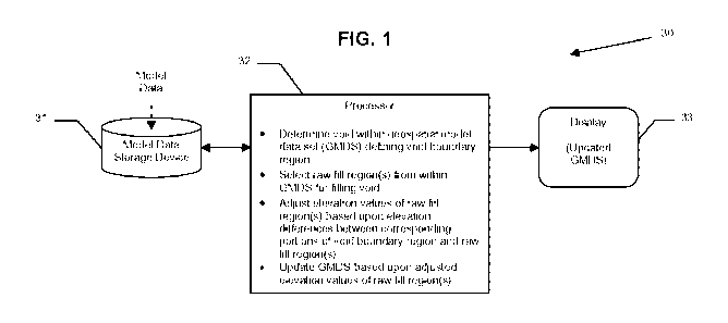
FIG. 1 is a schematic block diagram of a geospatial modeling system
in accordance with the invention.
FIG. 2 is a schematic geospatial model data set (GMDS) demonstrating
void filling using a single raw fill region by the system of FIG. 1.
FIGS. 3 and 4 are schematic GMDS's demonstrating iterative void
filling using a plurality of raw fill regions by the system of FIG. 1.
FIG. 5 is a screen print of a GMDS with a void therein.
-5-
CA 02702741 2010-04-15
WO 2009/052053 PCT/US2008/079726
FIG. 6 is a screen print of the GMDS of FIG. 5 after void filling using
an all-at-once (single fill) without updating of fill elevation values.
FIG. 7 is a screen print of the GMDS of FIG. 5 after void filling using
an all-at-once (single fill) approach with updated fill elevation values.
FIGS. 8(a)-8(d) are a series of 2D GMDS views illustrating a
differential surface void filling method in accordance with the invention.
FIGS. 9 and 10 are flow diagrams illustrating geospatial model data set
void filling method aspects of the invention.
The present invention will now be described more fully hereinafter
with reference to the accompanying drawings, in which preferred embodiments of
the
invention are shown. This invention may, however, be embodied in many
different
forms and should not be construed as limited to the embodiments set forth
herein.
Rather, these embodiments are provided so that this disclosure will be
thorough and
complete, and will fully convey the scope of the invention to those skilled in
the art.
Like numbers refer to like elements throughout, and prime and multiple prime
notation are used to indicate similar elements in alternative embodiments.
Referring initially to FIG. 1, a geospatial modeling system 30
illustratively includes a geospatial model data storage device 31, a processor
32, and a
display 33. The geospatial model data storage device 31 stores geospatial
model data,
such as digital elevation model (DEM), digital surface model (DSM), and/or
triangulated irregular network (TIN) data, for example. Generally speaking,
such
model data is generated from "raw" data captures, such as LIDAR, synthetic
aperture
radar (SAR), photography, electro-optical, infrared, etc., using systems such
as the
above-noted RealSite and LiteSite site modeling systems, as will be
appreciated
by those skilled in the art. Geospatial model data sets may be generated by
another
source and provided to the processor 32 for the additional processing
operations to be
described below, or the processor may generate the geospatial model data set
(i.e.,
from the raw data) in other embodiments.
By way of example, the processor 32 may be a central processing unit
(CPU) of a PC, Mac, Sun, or other computing workstation. A display 33 may be
-6-
CA 02702741 2010-04-15
WO 2009/052053 PCT/US2008/079726
coupled to the processor 32 for displaying modeling data. The processor 32 may
advantageously reconstruct or repair corrupted geospatial model data by
inpainting or
filling voids in the data, as will be discussed further below. While processor
32 is
illustratively shown and described herein as a single element, those skilled
in the art
will appreciate that the various functions of the processor set forth below
may be
implemented with a combination of hardware and software, and that these
software
components may be included in the same overall software application, for
example.
Referring now additionally to FIGS. 2-10, beginning at Block 90 the
processor 32 may advantageously cooperate with the geospatial model data
storage
device 31 for determining a void 41 within a geospatial model data set 40
(e.g., DEM,
etc.) defining a void boundary region 42 (FIG. 8(a)), at Block 91. More
particularly,
the void boundary region 42 includes the portion of the geospatial model data
set 40
surrounding or immediately adjacent to the void 41. As discussed above, it
will in
many circumstances be desirable to fill voids within a DEM or other geospatial
model
data set. Using an exemplar inpainting approach for void filling that allows
an entire
void region to be filled all-at-once (i.e., using a single fill or "patch")
can be very
efficient and lead to less chance for discrepancies between adjacent portions.
However, while this approach is relatively fast and does typically preserve
desired
texture, this approach also commonly results in edge effects or artifacts 51'
on the
boundaries of the void (see FIG. 6). This results from not being able to find
a
candidate or raw fill region 43 that substantially identically matches the
void (or
target) region 41.
When a single source or raw fill region 43 match cannot be found
when searching to fill the entire void 41 all-at-once, the void may be
iteratively filled
using a plurality of raw fill regions or patches, preferably one patch at a
time
(although other numbers are also possible). In this case, the chance for
visible seams
or artifacts 51' between each patch may be even more problematic than with a
single
patch. However, the desired experience is for the user to not be able to tell
from the
final product which areas have been filled. That is, it is desirable for there
to be little
or no visible artifacts 51' in the final displayed version of the DEM 40. Yet,
an
-7-
CA 02702741 2010-04-15
WO 2009/052053 PCT/US2008/079726
important consideration in removing boundary artifacts 51' is how to remove
such
artifacts in a way that does not disrupt the texture of the resulting DEM 40.
Moreover, because artifacts 51' at boundaries can be significant, a post-
filling
smoothing operation to address the artifacts may require significant
disruption of the
appearance of the filled data (i.e., the texture) to alleviate the
discrepancy.
In accordance with one advantageous aspect, the processor 32 selects
one or more raw fill regions 43 from within the geospatial model data set 40
for filling
the void 41, at Block 92. More particularly, the processor 32 may determine
whether
a single, suitable candidate fill region 43 exists within the data set 40 to
fill the void
41. This determination may be made by determining whether a single candidate
fill
region 43 provides a threshold level of accuracy or error correction. By way
of
example, the error threshold may be established by a customer specification,
and an
error level may be determined using a root mean square error (RMSE) approach,
etc.,
as will be appreciated by those skilled in the art. Further details on an
exemplary
error determination approach are provided in co-pending U.S. Patent App. No.
11/863,377, which is assigned to the present Assignee and is hereby
incorporated
herein in its entirety by reference.
If a single raw fill region 43 does not meet the specified error threshold
for a given geospatial model data set, then the processor 32 may proceed to
instead fill
the void 41' iteratively, i.e., one patch or fill region 43' at a time, as
shown in FIGS. 3
and 4. While various approaches may be used to determine which target portion
45'
of the void 41' to fill first, one approach is to select a top priority patch,
i.e., to fill the
target portion having a corresponding fill region 43' associated therewith
with a least
error based upon the void boundary, etc., as will be appreciated by those
skilled in the
art. Stated alternatively, the fill region 43' with the "best fit" for a given
target
portion 45' is used first. Subsequent patches (i.e., fill regions 43) may be
chosen in a
similar manner.
Once either an "all-at-once" fill region 43 or a partial fill region 43' is
selected, the processor 32 then adjusts elevation values of the selected raw
fill region
based upon elevation differences between corresponding portions of the void
-8-
CA 02702741 2010-04-15
WO 2009/052053 PCT/US2008/079726
boundary region 42 and the raw fill region, at Block 93, and updates the
geospatial
model data set 40 based upon the adjusted elevation values of the raw fill
region, at
Block 94, thus concluding the method illustrated in FIG. 9 (Block 95). The
foregoing
will now be further described with reference to the example illustrated in
FIGS. 8(a)-
8(d), which is a 2D geospatial model data set representation. The 2D
representation is
provided for clarity of illustration of the steps discussed herein, but it
will be
appreciated by those skilled in the art that these steps may also be performed
over the
3D surface area of the void 41, i.e., to fill the entire void and not just a
2D cross-
section thereof.
It should be noted that, as used herein, "3D" is meant to cover both
true three-dimensional model data as well as so-called 21/2 or 2.5D model
data. More
specifically, many DEMS or other geospatial model data sets are sometimes
referred
to as "2.5D" because they include rendered building walls, etc. that are not
necessarily present in the original data capture, and thus do not provide a
completely
accurate 3D image as it would appear to the human eye upon viewing a scene.
However, for clarity of discussed "3D" is meant to cover both cases herein.
As seen in FIG. 8(a), the processor 32 compares overlapping portions
of the void boundary region 42 and the raw fill region 43 to determine
differences
therebetween. Stated alternatively, upon overlaying the raw fill region 43 on
the void
boundary region 42, the processor 32 can determine differences between the two
at
the void boundary. By way of example, if the geospatial model data set 40 is
mapped
to a grid with spaced-apart posts, corresponding posts are aligned between the
void
boundary region 42 and the raw fill region 43, as will be appreciated by those
skilled
in the art. Here, on the left hand void boundary there is an elevation
difference x, and
on the right hand boundary there is an elevation difference y, as shown.
At this point, differences between the void boundary region 42 and the
raw fill region 43 within the void 41 cannot be determined, as there is no
data
available for the void boundary region at posts within the void (i.e., they
are null
points). The processor 32 therefore advantageously generates a differential
surface 46
along the length of the void boundary region 42 based upon differences between
the
-9-
CA 02702741 2010-04-15
WO 2009/052053 PCT/US2008/079726
void boundary region and the raw fill region 43 at each corresponding or
overlapping
post. For example, the processor 42 may take the average of the two elevation
values
at a given post, and use the average value to generate the differential
surface 46 with
the void 41 remaining therein (Block 100'), as seen in FIG. 8(b).
The values for the posts in the differential surface 46 that correspond to
the null posts in the void 41 are then determined or generated by
interpolation to
provide an interpolated fill 47 for the void 41, as seen in FIG. 8(c). Once
the
interpolated 61147, which provides interpolated or estimated difference values
between the void boundary region 42 and the raw fill region 43 within the void
41, is
determined, the elevation values of the raw fill region for the posts within
the void are
adjusted to provide adjusted elevation values based upon the interpolated
differential
surface 47. The adjusted values are represented as an adjusted fill region 48
in FIG.
8(d).
Further, the data set 40 is updated accordingly (i.e., the void 41 is filled
accordingly), as seen in FIG. 8(d), and displayed on the display 33 for the
user (Block
101') as needed. More particularly, the values are increased or decreased
accordingly
by the interpolated fill 47 value at the corresponding post, as will be
appreciated by
those skilled in the art (Block 93'). It should be noted that the processor 32
need not
actually generate the differential surface 46 and interpolated fill 47 for
display to the
user, even though visual representations thereof are provided in FIGS. 8(a)-
8(d) for
reference.
In those cases where a suitable single raw fill region 43 is not
available, the processor 32 may choose smaller raw fill regions 43' to
iteratively fill
the void 41, as noted above, using the same technique just described but for
the
smaller raw fill regions. After a raw fill region 43' has been filled in the
void creating
a new portion 44' therein, the new portion may now be treated as "truth" data,
i.e.,
just like it was part of the original void boundary region. This allows
subsequent raw
fill regions 43' to be similarly adjusted to reduce interior edge effects or
artifacts
between fill regions.
-10-
CA 02702741 2010-04-15
WO 2009/052053 PCT/US2008/079726
The results of the above-described approach for an all-at-once
exemplar inpainting operation are illustrated in FIGS. 5-7. A magnified view
of a
DEM 50 is shown in FIG. 5 with a void 41 therein. For comparison purposes, in
FIG.
6 the void 51 has been filled all-at-once using a single raw fill region from
within the
DEM 50 to generate the updated DEM 50'. As can be seen, artifacts 51' appear
at the
intersection of the void boundary region and the raw fill region (i.e.,
patch), as
indicated by the arrows. However, as seen in FIG. 7, when the differential
surface
approach described above is used, there is a decrease in artifacts at the
intersection of
the void boundary region and the raw fill region, which is again indicated by
arrows.
One significant advantage of the above-described approach is that it
utilizes a fill region(s) from within the same geospatial model data set with
the
void(s), so that there may be no need to provide a second, often expensive
(and
potentially time consuming to acquire) alternative fill source from which to
take the
raw fill region. This may provide significant time and production costs
savings.
Moreover, this approach is flexible enough to allow both all-at-once and
iterative
exemplar inpainting, so that users have more options depending on speed and
accuracy constraints for a given processor. That is, an all-at-once approach
may
provide quicker results, while the iterative approach may provide more
accurate fills,
particularly if relatively small patch or raw fill region 43' sizes are used,
as will be
appreciated by those skilled in the art. Further, accurate and efficient fills
may be
provided with little or no artifacts or edge effects that often result with
exemplar
inpainting operations.
The above-noted geospatial model method aspects may also be
embodied in a computer-readable medium having computer-executable instructions
for causing a computer or processor to perform the steps set forth above, as
will be
appreciated by those skilled in the art.
-11-