Note: Descriptions are shown in the official language in which they were submitted.
CA 02704322 2010-04-30
WO 2009/062286 PCT/CA2008/001806
METHOD FOR ACOUSTIC IMAGING OF THE EARTH'S
SUBSURFACE USING A FIXED POSITION SENSOR ARRAY
AND BEAM STEERING
Background of the Invention
Field of the Invention
[0001] The invention relates generally to the field of seismic evaluation
of formations in
the Earth's subsurface. More specifically, the invention relates to methods
for
determining seismic attributes in specific formations in the subsurface to a
relatively high
lateral and vertical resolution.
Background Art
[0002] Seismic surveying techniques are known in the art for deteimining
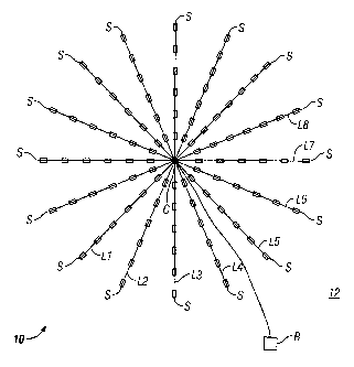
structure and
composition of rock formations in the Earth's subsurface. Reflection seismic
techniques
known in the art include deploying an array of seismic sensors above a part of
the
subsurface to be evaluated. The sensor array may be deployed on the land
surface, or in
marine surveys may be towed by a vessel near the surface of a body of water or
may be
deployed in a selected pattern on the water bottom. The array is typically
rectilinear in
shape and has substantially uniform spacing between individual sensors in the
array. A
seismic energy source is deployed near the array of seismic sensors and is
actuated at
selected times. Signals are detected by the sensors in the array and are
recorded. The
recordings are typically indexed with respect to the actuation time of the
seismic energy
source. The seismic signals typically include events caused by seismic energy
reflecting
from acoustic impedance boundaries in the subsurface. The time indexed records
from
each sensor are then processed to generate images of the rock formations, and
to evaluate
their petrophysical properties such as fluid content, mineral composition and
fractional
volume of pore space ("porosity").
[0003] Seismic surveying known in the art has relatively limited vertical
and lateral
resolution. Resolution limitations result from the fact that the Earth's
subsurface
CA 02704322 2010-04-30
WO 2009/062286 PCT/CA2008/001806
functions as a low pass filter to seismic energy. Typically only relatively
low frequency
seismic energy is able to travel from the source, through the subsurface and
back to the
seismic sensors having retained enough energy to be detected above the noise.
The
frequencies are usually below 80Hz. Images of the subsurface can be formed by
summing or "stacking" of the recorded signals in various manners and by a
process
known as migration. The vertical resolution obtained is determined by the
dominant
frequency associated with penetration to the depth in the subsurface of the
rock
formations being analyzed. The lateral resolution obtained depends on the
aperture size
and sensor spacing used for the signal collection of that portion of the data
that is
migrated. Various schemes are employed for the extraction of velocity versus
depth and
for geological interpretation. One example of a migration technique is
described in U.S.
Patent No. 6,466,873 issued to Ren et al.
100041 When seismic surveys are conducted with large arrays of sensors
deployed on the
seabed, for example, the lateral resolution of the images formed by migration
techniques
will again be determined by the selected sensor array aperture size and sensor
spacing.
The array aperture and sensor spacing ultimately will be limited by the cost
in data
processing time. Each point in the resulting images results from an aperture
that has been
moved along a much larger array of sensors and thus the image point is a
specular point.
Such fixed arrays are used for various reservoir studies.
100051 It is known in the art to perform seismic surveys repeatedly over a
same area of
the Earth's subsurface in order to determine changes in spatial distribution
of fluids in the
subsurface formations. Changes in spatial distribution of fluid over time can
result from
extraction of fluids, for example, producing hydrocarbon from the formations.
It is
desirable to have a method for seismic surveying that provides increased
resolution as
compared with techniques known in the art, for among other purposes, to be
able to
determine more precisely changes in spatial distribution of fluids disposed in
subsurface
rock formation as fluids are extracted from such formations.
2
CA 02704322 2013-06-11
=
Summary of the Invention
[0006] A method for seismic surveying according to one aspect of the
invention includes
disposing a plurality of seismic sensors in a selected pattern above an area
of the Earth's
subsurface to be evaluated. A seismic energy source is repeatedly actuated
proximate the
seismic sensors. Signals generated by the seismic sensors in response to
detected seismic
energy, indexed in time with respect to each actuation of the seismic energy
source are
recorded. The recorded signals are processed to generate an image
corresponding to at
least one point in the subsurface. The processing includes stacking recordings
from each
sensor for a plurality of actuations of the source and beam steering a
response of the
seismic sensors such that the at least one point is equivalent to a focal
point of a response
of the plurality of sensors.
[0006a] In accordance with another aspect of the present invention, there
is provided a
method for seismic surveying, comprising: disposing a plurality of seismic
sensors in a
selected pattern proximate an area of the Earth's subsurface to be evaluated;
repeatedly
actuating a seismic energy source proximate the area to be evaluated;
recording signals
generated by the seismic sensors indexed in time with respect to each
actuation of the
seismic energy source; and processing the recorded signals to generate an
image
corresponding to at least one point in the subsurface, the processing
including stacking
recordings from each sensor for a plurality of actuations of the source and
beam steering
a response of the seismic sensors such that the at least one point is
equivalent to a focal
point of the response of the plurality of sensors.
[0007] Other aspects and advantages of the invention will be apparent from
the following
description and the appended claims.
3
CA 02704322 2013-06-11
,
=
Brief Description of the Drawings
[0008] FIG. 1 shows an example of a sensor array used for subsurface
imaging according
to the invention.
[0009] FIG. IA shows a seismic energy source array that may be used
with the array
shown in FIG. 1.
[0010] FIG. 1B shows a plurality of seismic energy sources that may be
used in some
examples for directed subsurface illumination.
[0011] FIG. 2 shows an example of seismic sensor distribution along
one line of an array
such as shown in FIG. 1.
[0012] FIG. 3 shows a cross section of the subsurface to illustrate
lateral evaluation
capability of an array such as shown in FIG. 1.
[0013] FIG. 4 is a graph of seismic signal amplitude to noise ratio
for various attenuation
rates with respect to frequency and acoustic energy travel length.
3a
CA 02704322 2010-04-30
WO 2009/062286 PCT/CA2008/001806
[0014] FIG. 5 is a graph of seismic signal to reverberation amplitude for
various pore
sizes with respect to frequency and acoustic energy travel length.
Detailed Description
[0015] An objective of methods according to the present invention is to
provide a
localized examination of subsurface Earth structures with higher resolution
(both laterally
and vertically) than is typically possible using conventional seismic
surveying. In some
examples, the localized examination may be repeated at selected times to
determine
changes in spatial distribution of fluids in subsurface rock formations.
Various examples
of methods according to the invention may provide such enhanced resolution
examinations at depths of 1.0 km to 3.5 km below the Earth's surface, or in
examples in
marine environments within a similar range of distances below the water
bottom. The
particular examined volume within the Earth's subsurface to be evaluated may
be
selected from prior, conventional seismic surveys, for example. In methods
according to
the invention relatively high frequency (as contrasted with conventional
seismic) seismic
energy is used, and coherent stacking from multiple actuations of a seismic
energy source
is used to mitigate the attenuation of such higher frequency energy which
occurs as a
result of the acoustic properties of the subsurface rock formations. The
vertical
resolution of a seismic survey made according to various examples of the
invention can
thus be better than that obtainable from conventional seismic surveys.
[0016] The lateral resolution of surveys made according to the invention
depends, as is
the case for conventional seismic surveys, on the aperture size of an array of
seismic
sensor used. Data processing according to the invention, however, is
relatively fast as
contrasted with convention seismic data processing because it is based on the
steering of
focused beams, rather than on depth or time migration analysis. Methods
according to
the invention thus can provide the ability to monitor subsurface reservoirs
during
production using time-lapse imaging, allowing a better understanding of the
movement of
fluids in such subsurface reservoirs.
4
CA 02704322 2010-04-30
WO 2009/062286 PCT/CA2008/001806
[0017] An example seismic sensor array that may be used with the invention
is shown
schematically at 10 in FIG. 1. In the example shown in FIG. 1, the seismic
sensor array
may be disposed on the bottom of a body of water 12 such as a lake or the
ocean. The
seismic sensor array 10 may include individual seismic sensor cables L1
through L8.
The cables L1 through L8 may include a plurality of spaced apart seismic
sensor modules
S disposed along the length of each seismic sensor cable L 1 -L8. Each of the
seismic
sensor modules S may include a so-called "four-component" seismic sensor (not
shown
separately). "Four-component" seismic sensors typically include three,
orthogonally
oriented particle motion responsive sensors such as geophones or
accelerometers, and a
substantially collocated pressure or pressure time gradient responsive sensor
such as a
hydrophone. See, for example, U.S. Patent No. 5,774,417 issued to Corrigan et
al. for an
example of such four component seismic sensors used in a sensor cable for
deployment
on the bottom of a body of water. Examples of the longitudinal spacing between
sensor
modules and the number of the sensor modules S on each seismic sensor cable L
1 -L8
will be further explained below with reference to FIG. 2. Each seismic sensor
(not shown
separately) in each sensor module S may generate electrical and/or optical
signals related
to the parameter being measured (e.g., velocity, acceleration, pressure or
pressure time
gradient). The sensor signals may be communicated according to the type of
sensor
output signal to a recording unit R. The recording unit R may be disposed on
the water
bottom, or in a buoy near the water surface for signal record storage and
later retrieval.
[0018] A seismic energy source W, which may be an air gun array or water
gun array, or
other suitable sources, such as magnetostrictive or piezoelectric transducers
may be
disposed proximate the center C of the sensor array 10. The source W is
actuated at
selected times, and a time indexed record of the signals produced by each
sensor in each
module S can be recorded in the recording unit R for later analysis.
Particular
characteristics of the seismic energy source W will be further explained
below.
[0019] The seismic sensor cables L1-L8 may be arranged in a radial pattern
as shown in
FIG. 1. The seismic sensor cables Ll -L8 in the present example may be
symmetrically
arranged about the center point C of the array 10 and angularly displaced from
each other
by an angle of about 221/2 degrees. In other examples, fewer or more cables
may be used
5
CA 02704322 2010-04-30
WO 2009/062286 PCT/CA2008/001806
than is shown in FIG. 1. It is contemplated that in such other examples the
angular
displacement between each of the cables will be approximately equal, however
equal
angular displacement between sensor cables is not a limit on the scope of the
present
invention. The radial sensor cable arrangement shown in FIG. 1 may be
advantageous in
calculated beam steering of the sensor response. However, other geometric
arrangements
may be used that can be beam steered according to the invention.
[0020] FIG. 1A shows an example of the seismic energy source W in more
detail. The
source W may consist of a plurality of individual air guns or water guns or
other suitable
seismic energy sources such as explained above, shown at W1 through W5
arranged in a
small-diameter, generally circular pattern. The individual sources w1-w5 may
be
actuated by a source controller W6, which may be in operative communication
with the
recording unit (R in FIG. 1) so that the signal recordings may be time indexed
to the
actuation time of the source W. In the present example, the source controller
W6 may be
configured to successively, individually (or in subsets or subcombinations)
actuate each
source W1 -W5 at a selected time delay (which may be zero or any other
selected time
delay) after the actuation of the first one of the sources W1 -W5. The time
delay may be
selected such that the energy output of the array of sources W1-W5 is oriented
substantially along a selected direction. In such examples, the directivity of
the source W
may be used to further illuminate subsurface features identified during signal
processing
or otherwise. Such specific illumination will be further explained below with
reference
to FIG. 3.
[0021] Another possible implementation having even greater source focusing
capability
than the example shown in FIG. 1A is shown in FIG. 1B. The example shown in
FIG. 1B
includes a first seismic energy source disposed at a first selected position
being a selected
radial distance from the center of the array 10. The example shown in FIG. 1B
has such
first positions being along each of the seismic sensor cables L1-L8. Such
seismic energy
sources are shown at W2B through W17B, inclusive. A second seismic energy
source
may be placed at a second selected position being a second radial distance
from the
center of the array 10. The example of FIG. 1B has these positions being along
each of
the sensor cables L 1 -L8. Such second sources are shown correspondingly at
W2A
6
CA 02704322 2010-04-30
WO 2009/062286 PCT/CA2008/001806
through W17A inclusive. A seismic energy source W1A may also be disposed
proximate
the center of the array 10. The seismic energy sources W1A through W17A and
W2B
through W17B may be controlled by a seismic source controller similar in
function to the
device described above with reference to FIG. lA at W6. In the In the example
shown in
FIG. 1B, the seismic sources may in combination form a steerable beam array
having an
aperture of about two wavelengths of the seismic energy emitted by the
sources. The
actuation time of the individual sources W1A through W17B may be selected to
result in
a seismic energy beam directed toward a selected subsurface location.
Actuation of the
sources with selected delay timing as above may be repeated with different
time delays
for each individual source to selectively illuminate different positions in
the subsurface.
[0022] It has been determined through response simulation that using the
additional
seismic sources W2A through W17B as explained above provides good beam
steering
response when each first source position is about one wavelength of the
seismic energy
from the center of the array 10, and each second source position is about two
wavelengths
from the center of the array 10. The arrangement shown in FIG. 1B includes
having the
first and second source positions along each sensor cable L1-L8, however, the
sources do
not need to be so located. The seismic energy sources can be located at any
circumferential position with respect to the sensor cables.
[0023] A longitudinal spacing between seismic sensor modules on each
sensor cable, and
a number of such seismic sensor modules on each cable may be determined by the
frequency range over which a seismic analysis of the subsurface rock
formations is to be
performed. Such seismic frequencies, of course, must have been radiated by the
seismic
energy source. Selection of suitable frequency for the seismic energy source
will be
explained in more detail below. The longitudinal spacing between seismic
sensor
modules forming the receiver array is preferably selected such that for a
particular
seismic frequency the spacing should not be greater than about one-half the
seismic
energy wavelength. At each frequency an example cable length may be about 80
to120
wavelengths of the longest wavelength seismic energy frequency. Thus, it is
possible to
use an array having sensor cables of overall length 120 wavelengths at the
lowest
frequency, but variable longitudinal spacing along each cable between the
seismic sensor
7
CA 02704322 2010-04-30
WO 2009/062286 PCT/CA2008/001806
modules, so that the overall array will include 120 wavelength-long sensor
arrays at
higher frequencies with a half-wavelength spacing at such higher frequencies.
The sound
speed (seismic velocity) used to determine the wavelength is that within the
rock
formations near the water bottom (or the Earth's surface in land based
surveys).
100241 An example of possible longitudinal spacing between seismic sensor
modules (S
in FIG. 1) and numbers of such seismic sensor modules is shown schematically
in FIG. 2.
The seismic sensor modules (S in FIG. 1) may be more closely spaced along each
cable L
nearest the center point (C in FIG. 1) of the array (10 in FIG. 1), becoming
more sparsely
spaced toward the longitudinal end of each cable L. In the example shown in
FIG. 2, a
centermost portion 10 of the cable L can be about 182 meters long and have 160
sensor
modules spaced apart from each other by about 1.14 meters. Laterally adjacent
on either
end of the centermost portion 20, a first lateral portion 22 may include 11
sensor modules
spaced apart from each other by about 1.33 meters and have an overall length
of about 15
meters. A second lateral portion 24 may be disposed laterally adjacent each
first portion
22 and have 13 sensor modules spaced about 1.6 meters from each other and have
overall
length of about 20 meters. Respective third 26 and fourth 28 lateral portions
may be
adjacent as shown in FIG. 2 and include, respectively, 16 and 20 sensor
modules spaced
apart by 2 and 2.67 meters, and have overall length of 32 and 53 meters.
Overall, each
cable L in the array (10 in FIG. 1) may include 280 sensor modules and have
length of
about 422 meters. Other lengths and sensor module spacings may be used. It is
contemplated that the sensor module spacing in the present example, when used
in
conjunction with a seismic energy source (W in FIG. 1) having substantial
energy in a
frequency range of about 300 to 700 Hz, will provide high resolution images at
depths
below the water bottom of 1 to 3 kilometers. The lateral resolution of the
measurements
made by the array will increase as the length and the number of sensor modules
on each
cable L is increased. Vertical resolution of the measurements made by the
array is related
to the frequency content of the seismic energy.
[0025] Referring to FIG. 3, the sensor array 10 is shown disposed on the
bottom 12A of
the body of water 12. The water top is shown at 12B. Methods according to the
invention may provide increased resolution images of subsurface formations,
such as
8
CA 02704322 2010-04-30
WO 2009/062286 PCT/CA2008/001806
shown at 14, and may provide the capability to image within an aperture
defined by an
angle shown at a in FIG. 3. It is believed high resolution images may be
obtained at
angles of 45 degrees or more using methods of the present invention.
[0026] In methods according to the invention, the seismic energy source (W
in FIG. 1)
may be of a type to provide substantially higher frequency energy than is used
in
conventional reflection seismic surveys. As will be explained below, in
methods
according to the invention the fact that the source W and the array 10 are
stationary
provides that the source W may be actuated repeatedly so that attenuation of
higher
frequency energy by the subsurface formations may be alleviated by summing or
stacking
signals from the repeated actuations.
[0027] In selecting a frequency output for the seismic energy source (W in
FIG. 1) the
following may be considered. A reasonable expectation for attenuation of the
seismic
energy as it moves through the rock formations would be about 0.1dB
attenuation per
wavelength of the seismic energy as is emanates from the source (W in FIG. 1).
Table 1
shows a relationship between seismic energy attenuation and center frequency
of the
seismic energy, and provides guidance as to how much signal gain may be
required at
higher frequencies in order to have similar reflection signal strength as that
of a
conventional seismic survey. Conventional seismic surveys typically have at
most about
120 Hz center frequency seismic energy, although in practice a more common
center
frequency range is about 50 to 80 Hz. The attenuation to 1000 m depth below
the Earth's
surface (or the water bottom) for a seismic energy velocity of 3000 meters per
second can
be calculated as (2*1000*120/3000)*0.1 = 8dB. To a depth of 3500m the
corresponding attenuation is about 28dB.
9
CA 02704322 2010-04-30
WO 2009/062286
PCT/CA2008/001806
TABLE 1
Freq Wavelength Two way Two way Two way
Gain needed for focused survey
Hz (m)
Attenuation Attenuatio Attenuation over conventional seismic survey
to 1000m n to 2000m to 3500m (dB)
(dB) (dB)
(dB) 1000m 2000m 3500m
(7dB (4dB (2dB
spreadi spreading spreading
ng gain) gain)
gain)
120 25 8 16 28
200 15 13 26 46 -2 6 16
300 10 20 40 70 5 20 40
400 7.5 27 54 94 12 34 64
500 6 33 66 115 18 46 85
600 5 40 80 140 25 60 110
700 4.3 47 94 164 32 74 134
100281 The
purpose of selecting a range of frequencies which is higher than that used for
conventional seismic surveys, is to increase the vertical resolution and to
maintain or
increase the lateral resolution of the resulting seismic data while benefiting
from the
practical aspects of physically smaller sensor array apertures. Choosing a
range of
frequencies for which seismic data from various depths down to 3500m and
beyond can
be obtained requires consideration of a number of factors. Of great importance
is the
attenuation rate of the seismic energy, as suggested above. Attenuation may be
quantified in dB attenuation per wavelength of energy travel. It is known in
the art that
satisfactory seismic survey results may be obtained when the attenuation is
between
about 0.1 and 0.16 dB per wavelength. The seismic signal returned to the
receivers
(sensors) must be sufficiently high amplitude above the ambient noise, for
example about
dB above the noise, for the seismic signals to be useful for subsurface
evaluation. The
foregoing relationship between the seismic signal amplitude and the ambient
noise is
termed the signal to noise ratio and it is related to the seismic energy
source strength, the
attenuation, the seismic energy center frequency, the seismic energy bandwidth
around
the center frequency, the geometrical spreading loss, the number of receiving
sensors and
the prevailing ambient noise.
CA 02704322 2010-04-30
WO 2009/062286 PCT/CA2008/001806
[0029] FIG. 4 shows a graph of one way seismic energy travel path length
(related to the
depth to which evaluation may be performed in the subsurface) that will result
in signal
to noise ratio of 10 dB for various seismic energy center frequencies. Each
curve in FIG.
4 represents a unique value of attenuation (in dB per wavelength ranging from
0.08 to
0.16 in 0.02 increments). In generating the curves in the graph in FIG. 1, the
seismic
energy speed was set at 2333 m/s, the beam width of the received seismic
energy was set
at 1.5 degrees, and recordings from 1000 actuations of the seismic energy
source were
combined or stacked. In a method according to the invention, because the array
(10 in
FIG. 1) and the seismic energy source W are substantially stationary as
explained above,
the seismic signals obtained from a plurality of actuations of the seismic
source can be
added together or stacked to provide gains in signal to noise.
[0030] In addition to the signal to noise ratio, another factor that must
be considered is
the signal to reverberation ratio. The desired seismic signal is associated
with the signal
returned from that portion of the subsurface environment for which the
receiving array of
sensors has been focused and steered (explained further below). At the same
time as the
desired seismic signal, other signals are returned from the subsurface due to
scatter from
within a depth "shell" of thickness determined by the bandwidth of the seismic
energy
and subtending a solid angle dependent on the illumination and weighted in
angle by the
seismic sensor array beam pattern. The sum of all these signals constitutes
what is
known as reverberation. FIG. 5 shows example calculations of reverberation
where the
reverberation is due to scatter by pores in the subsurface formations. As an
example
comparison with the graph shown in FIG. 4, at 300Hz, for attenuation of 0.16
dB per
wavelength, the signal to noise ratio for stacked signals from 1000 source
actuations
would be 10dB for an echo from a weak interface of impedance contrast 0.01 at
a depth
of 2250 m. For the same situation, FIG. 5 shows the signal to reverberation
ratio would
be 10dB less than the signal to noise ratio for scatter from pores having an
average size of
7 mm. The results shown in FIG. 4 and FIG. 5 are for calculations based on
simple
models but are indicative of underlying fundamental limitations to the method
of the
invention. The signal to noise increase provided by stacking signals from
repeated
actuations of the source are important to the operation of the invention. As
an example,
11
CA 02704322 2010-04-30
WO 2009/062286 PCT/CA2008/001806
the two-way seismic energy travel time to a formation depth of 3500 m is about
2.5
seconds for a seismic velocity of 3000 meters per second. The seismic energy
source
may then be actuated repeatedly every 3 seconds for a total time duration of
about 3
hours. The gain thus provided would be 10 log (3*60*60/3) = 35 dB. If the
total time
interval is doubled to 6 hours the gain would be about 38dB. Any further
doubling of the
time interval would add 3 dB. It should also be noted that further gain of 6
dB is
provided when combined three component particle motion-plus pressure-responsve
sensors are used, as contrasted with pressure-responsive sensors (hydrophones)
are used
alone as explained with reference to FIG. 4.
[0031] While the signal to noise may be improved by coherent summations or
stacking,
the signal to reverberation may be improved by increasing the directivity of
the source.
In some examples, and as explained above with reference to FIG. 1A, a steered
source
may be used, designing appropriate shading procedures for the receive beam to
reduce
the sidelobes and by increasing the analysis bandwidth from the 1/3rd octave
value known
in the art.
[0032] The use of prior knowledge of the velocity structure of the
subsurface is important
to successfully steer and focus the seismic sensor array beams. Iterative
focusing
strategies may be used to enhance and improve the focusing and thereby further
improve
determination of the spatial distribution of seismic properties in the
subsurface.
[0033] A further application of the invention is in the investigation of
the upper layers of
the seabed. Placing the seismic energy sources on the seabed at various
distances from
the sensor array can also be used to record and interpret surface waves. With
the acoustic
or elastic source deployed at or near to the seabed, the wavefield will
contain significant,
high-energy surface waves. These waves propagate radially from the source
within the
uppermost sediment layers and penetrate typically about one shear-wave length
within
the subsurface, and are closely related to shear waves. As contrasted with
body waves,
surface waves exhibit distinct dispersive natures and propagation velocities
with
frequency dependencies. The occurrence of multiple surface wave modes at
particular
frequencies in vertically stratified media can then be used to obtain an
accurate
12
CA 02704322 2010-04-30
WO 2009/062286 PCT/CA2008/001806
geophysical model of the uppermost layers in the subsurface to a depth of tens
of meters
in the subsurface.. Such models are of great value for geohazard assessment,
geotechnical characterization and offshore engineering purposes, which are
important for
risk assessment and mitigation within offshore industry practices.
[0034] In addition to recording the compressional wave arrivals, the
method will also
have the capability to record shear wave arrivals. Such data can be inverted
as mentioned
above and knowledge of the ratio of compressional to shear wave speeds is of
great use in
the geophysical interpretation.
[0035] If the source (W in FIG. 1) output for the survey arrangement
shown in FIG. 1 is
reasonably similar to that used in a conventional seismic survey, then for a
depth in the
subsurface of 1000 m, a frequency of 700 Hz would need to have a gain of 32dB
in order
to have similar signal strength to a 120 Hz center frequency conventional
seismic survey.
For penetration depth in the subsurface to 3500 m, a frequency of 300Hz would
need to
have a gain of 40 dB over that of a conventional 120 Hz seismic survey. In a
method
according to the present invention, as stated above because the source (W in
FIG. 1) and
the array (10 in Fig. 1) are stationary, the required gain may be provided by
repetitively
actuating the source (W in FIG. 1) and summing or stacking recordings made for
each
actuation for each sensor in each sensor module (S in FIG. 1).
[0036] As an example, the two-way seismic energy travel time to a
formation depth of
3500m is about 2.5 seconds for a seismic velocity of 3000 meters per second.
The
source may then be actuated repeatedly every 3 seconds for a total time
duration of about
3 hours. The gain thus provided would be 10 log(3*60*60/3) = 35dB. If the
total time
interval is doubled to 6 hours the gain would be about 38dB. Any further
doubling of the
time interval would add 3dB. It should also be noted that further gain of 6dB
is provided
as contrasted with pressure sensors (hydrophones) used alone when vector-
velocity-plus-
pressure sensors are used as explained with reference to FIG. 1.
[0037] Based on the foregoing analysis, together with detailed studies of
the expected
noise and reverberation for a range of frequencies, receiving array processing
schemes,
available seismic source strengths and dispositions, a reasonable practical
choice of the
13
CA 02704322 2010-04-30
WO 2009/062286 PCT/CA2008/001806
source frequency for penetration to 1000m below the water bottom is up to
700Hz, while
for penetration to 3500m the maximum frequency, depending on prevailing
conditions
could be as high about 300Hz.
[0038] Four-component sensors, if such as used, provide three components
of the vector
acoustic intensity together with the acoustic pressure. Thus, in contrast to
pressure-only
sensors, each sensor has its own beam pattern, and in marine surveys in
particular, allows
for the significant discrimination against energy arriving from above the
seabed. (This
includes the sea surface reflections of energy arriving from the seabed at
earlier times.)
Using velocity vector and pressure as the received signals can provide, as
explained
above, additional 6dB gain over the use of pressure sensors alone in the
forward direction
while providing substantial front to back discrimination.
[0039] In a method according to the present invention, signals from the
seismic sensor
array 10 may be processed to focus the sensitivity of the array 10 to any
selected focal
point (e.g., P) in the subsurface. Such focusing may be performed, for
example, by
applying a suitable time delay to the signals recorded by each individual
sensor in the
array 10. The time delay may be selected, for example, such that arrival time
of seismic
energy from each selected point P to each seismic sensor is substantially
identical, or may
be selected to create the effect of a plane wave emanating from the focal
point P.
Because the spatial distribution of seismic velocities in the subsurface may
be determined
beforehand using conventional seismic velocity analysis, the time delay may be
accurately determined prior to conducting a survey using the array 10 or prior
to
processing the signal recordings. During the seismic survey technique
according to the
invention, a plurality of individual focal points may be selected throughout
the area of the
subsurface that is being examined.
[0040] If during the seismic survey acquisition and/or procedure a point
of interest (e.g.,
at P) is located in the subsurface, either or both of the following
supplemental acoustic
illumination procedures may be performed. First, the time delay for operating
each
energy source in the source array (see FIG. 1A and FIG. 1B) may be selected to
direct the
output of the source (W in FIG. 1) or sources (FIGS. 1A and 1B) toward the
point of
14
CA 02704322 2010-04-30
WO 2009/062286 PCT/CA2008/001806
interest. Alternatively, or in addition, an auxiliary source WA may be
disposed at a
position on the water bottom substantially directly above the point of
interest in order to
obtain zero incidence illumination of the point of interest. The auxiliary
source WA may
also be used with the seismic energy source arrangements shown in FIG. 1A and
FIG.
1B.
[0041] The method described above may be repeated at selected times in
order to
determine, for example, changes in spatial distribution of fluids within rock
formations in
the subsurface. Such procedure may provide higher resolution mapping of the
spatial
distribution than conventional "4D" seismic surveying, and may provide earlier
detection
of subsurface reservoir damage such as water "coning" or unintended fluid
movement
resulting from permeability anistotropy.
100421 An example data acquisition and operational method may be described
as follows.
If 3D seismic data are available first it is desirable to examine the data for
an area above
the subsurface volume to be analyzed. Such examination may provide a location
for the
sensor array (10 in FIG. 1) to be positioned.
100431 Next the sensors in the sensor modules (S in FIG. 1) may be
calibrated by
transmitting seismic signals laterally along the array. Next may be
determining the
maximum and minimum directive response for sensor module. As explained above,
in
some examples each sensor module may include a pressure responsive sensor and
a three
component particle motion responsive sensor. Directivity distribution of the
sensor
response may be determined.
100441 After calibration of the sensors in the various modules, data
acquisition may be
performed. As explained above, for certain depth ranges in the subsurface and
for certain
desired frequency response, it may be desirable to record signals from as many
as 1,000
successive actuations of the seismic energy source(W in FIG. 1).
[0045] Once a sufficient number of source "shots" are acquired and summed
or
"stacked", the signal to noise ratio with respect to time for the recorded
signals may be
examined to ensure sufficient signal levels are present for forming beams. If
the signal
CA 02704322 2010-04-30
WO 2009/062286 PCT/CA2008/001806
level is too low stacking of signals from individual actuations can be
continued. As
explained above, it is desirable to have about 10 dB signal above the noise
floor
[0046] The existing 3D seismic data may also be used to estimate seismic
velocity
distribution for the site. Using the 3D velocity distribution from seismic
data, a ray
tracing model of the beams steered at depth may be initiated. The ray tracing
model may
correct for the influence of the near surface formations on the beam profile.
The ray
modeling will show the distortions of the beam caused by specific geology,
which then
can be used to correct for the effects of a particular set of near surface
formations.
[0047] The sensor data in the near surface time histories can be examined
to identify
densely-sampled, multi-component seismic data surface waves. With the seismic
energy
source deployed at or near to the water bottom, the detected seismic signals
(wavefield"
will contain significant, high-energy surface waves. Because of the
arrangement of
seismic source and sensors as shown in FIG. 1, such surface waves may
propagate
radially along the directions of the "arms" of the sensor array (e.g., sensor
lines L1-L8 in
FIG. 1). Such radially propagated seismic waves within the uppermost formation
layers
may be processed by analyzing their distinct dispersive nature. Dispersion may
be
processed by accounting for changes in surface wave velocity profile because
surface
wave velocities are typically frequency dependent.
[0048] Processing the occurrence of multiple surface wave modes at given
frequencies in
the vertically stratified media may be performed to obtain a highly accurate
geophysical
model of the shallowest formations (i.e., formation depths in a range of
meters to tens of
meters into the sub-surface, depending on the frequency) combining forward
modeling
and inversion techniques to help analyze the returns.
[0049] Because shear wave velocity is directly related to shear modulus of
a particular
material, the analysis can be directed at retrieving information about the
dynamic
characteristics of the formations in the near surface Knowledge of the
overburden can be
used to filter any noise and to correct for any dominant anomaly which may
influence the
steering of the beams.
16
CA 02704322 2010-04-30
WO 2009/062286 PCT/CA2008/001806
[0050] In performing a method according to the invention it may be
desirable to form as
many beams as required to sweep a particular targeted geological feature in
the
subsurface The resulting images and seismic attributes thus formed at a given
location
(at a beam focusing point or area of interest in the sub surface which one
wishes to
specifically illuminate) will have as many independent points as there are
independent
beams formed.
[0051] In some examples it may be desirable to use iterative focusing
strategies to
enhance and improve the focusing and thereby further our knowledge of the
geology of
the environment. One example of such iterative focusing may include
illuminating
specific points or areas in the subsurface from different angles, for example
by using the
auxiliary source as explained above.
[0052] To mitigate the influence of the beam's sidelobes and to improve
the detectability
of reflected signal returns on the main beams, the beams should be shaded
using routine
shading techniques such as the Hann and/or Chebyshev window techniques. Such
techniques are described, for example, in, George, J., Beamforming with Dolph-
Chebyshev Optimization and Other Conventional Methods, Naval Oceanographic and
Atmospheric Research Lab, Stennis Space Center (1991). In such examples, once
specific
targeted features in the subsurface are detected it is possible to improve the
lateral
definition of the beam by removing the shading gradient applied.
[0053] As explained above with reference to FIG. 1A and FIG. 1B, the time
delay for
operating each transmitter or energy source in the respective arrays may be
selected so
that .the output of the source is primarily directed towards a specific point
of interest.
[0054] In addition, and as explained above, an auxiliary source may be
disposed at a
position on the water bottom directly above a point of interest in order to
obtain near zero
incidence illumination of the point of interest and hence augment the angular
return to the
receiving array. To augment the velocity values for various subsurface
stratigraphies, the
auxiliary source can be deployed at multiple selected locations . New times of
arrival of
signals from the subsurface can be logged in. The specific capturing of the
shear wave
17
CA 02704322 2010-04-30
WO 2009/062286 PCT/CA2008/001806
velocity at a geological feature can be performed and a ratio between VsNp can
be
produced.
[0055] In another example, after determining that a particular subsurface
area is of
interest, the signals from a plurality of the seismic sensors may be
multiplied, rather than
summed, to increase the signal to noise ratio of the seismic signals from the
area of
interest. In another example, the foregoing process may be repeated in its
entirety at
selected times to determine changes in properties of the subsurface formations
over time,
such as movement of fluids in a subsurface reservoir. Such movement may be
determined, as explained above herein, by determining changes in apparent
spatial
distribution of subsurface featured inferred to be a boundary between
different types of
fluids in the subsurface.
[0056] While the invention has been described with respect to a limited
number of
embodiments, those skilled in the art, having benefit of this disclosure, will
appreciate
that other embodiments can be devised which do not depart from the scope of
the
invention as disclosed herein. Accordingly, the scope of the invention should
be limited
only by the attached claims.
18