Note: Descriptions are shown in the official language in which they were submitted.
CA 02705505 2010-05-12
WO 2009/062935 PCT/EP2008/065331
1
Forming A Geological Model
The present invention relates to a method of forming a geological model.
Seismic traveltime data and well marker data are integrated in every petroleum
reservoir for improved knowledge of oil-in-place, hydrocarbon heterogeneities,
risk
evaluation, and in general for making better decisions about both drilling and
drainage
strategies. The way seismic and well data are integrated differs dramatically
and
depends heavily on the main objective of study. To obtain the best out of the
data, one
must take into account the uncertainty associated with each data type.
Consider for
instance the thickness of an oil reservoir; One data source (wells) tells you
it is 30m,
the second (seismic) says 50m. How much is this reservoir worth in terms of
net
present value? Should we start producing hydrocarbons? If the critical
thickness based
on the cost and expected revenues is 40m, we would have to trust the first
source less
than the second to start production.
Seismic data are acquired by emitting sound from a source such as an air gun
and
then monitoring the reflected signal at a set of receivers. There is a huge
literature on
converting such reflection data to a structural model for the subsurface,
represented in
(east, north and depth) coordinates. The most common method is to process
manually
picked reflection times (traveltimes) from main geological interfaces by
collecting them
to fixed surface reference positions, and then stretching the traveltimes
(measured in
seconds) according to a priori known velocity. One caveat with this method is
its lack of
ability to capture the three dimensional uncertainty in the structural model.
Another is
the implicit assumption that each surface reference point represents a
reflection point
directly underneath, and not from another reflector to the east or north of
the surface
location. The second assumption (referred to as 'vertical stretch' since only
the depth
dimension is influenced in the structural imaging) can be bypassed with more
complicated depth conversion methods, for instance by using ray tracing, but
the
problem of capturing the three dimensional structural uncertainty remains.
Well marker data consists of geographical (east, north, depth) picks as the
well goes
through a geological marker. These markers typically include the interfaces
detected
on seismic data. Traditionally, well data have been treated as fixed, known
measurements, or at least relatively so compared to the noisy seismic data.
However,
CA 02705505 2010-05-12
WO 2009/062935 PCT/EP2008/065331
2
with the aid of modern computers, seismic processing is more reliable and the
signal to
noise ratio is improved. At the same time, well technology has caused a major
increase
in the number of deviated and deep (5 km depth) wells. The measured positions
of
wells are then less reliable. This means that the well marker data cannot be
treated as
fixed, known geographical positions, simply used to scale the seismic data
from time to
depth domain. Nowadays, the uncertainties of well marker positions logged
while
drilling and vary according to the equipment used. This has improved the risk
analysis
during drilling operations. The main limitation of current technology is
including the well
marker position and position accuracy into the broader picture of three
dimensional
positioning. This entails integrating the geographical reference interfaces in
east, north,
depth coordinates from well markers with the seismic reflection data. Wells
are sparse
(10-50 wells per oil field) and carry little information about the lateral
continuity of a
reservoir. Seismic data, on the other hand, are abundant and laterally
informative, but
are not directly comparable at the well marker east, north, depth scale.
Optimal methods for integrating diverse data at a common scale are known. This
is text
book statistics, in broad terms referred to as least squares estimation. Tools
for
representing seismic data in east, north and depth coordinates and integrating
these
data with geographical well marker data have been lacking, particularly at the
level
where one can deduce the three dimensional positioning uncertainty. The
traditional
way of updating is in the vertical direction. For almost flat horizons, this
gives a reliable
method but, for dipping layers, curved surfaces or faults, this can introduce
bias.
Methods for orthogonal shifting of dipping surfaces have been proposed, but
this is still
an ad-hoc technique that does not capture intrinsic direction variability that
can actually
be physically modelled using, for instance, ray-tracing. Moreover, consistent
assessment of uncertainties is important to make fast decisions in high
dimensional
reservoir systems. The current state of the art is driven by a search for the
'best'
structural model, without controlling the data going into the estimation.
Hence, updating
the geographical model is by current standards a tedious process with too much
work
being done on reiterating the data and trying to match information that cannot
be
unified.
EP1306694 discloses a method of combining first and second models of a common
region of space, such as a region of the earth below the surface, to form a
third model.
Common points have different positions in the first and second models. A
CA 02705505 2010-05-12
WO 2009/062935 PCT/EP2008/065331
3
predetermined correlation exists between the positions of the common points in
the first
model and the positions of points of interest in the first model. The
positions of the
common points in the third model are derived from the common point positions
in the
first and second models. The positions in the third model of the points of
interest are
derived from the positions of the common points in the third model and from
the
predetermined correlation.
GB 2352746A discloses a method of producing impact point position probability
maps
for a well. A fixed target point is defined at an initial location of a
surface with the aid of
a grid composed of nodes and of grid cells. An uncertainty vector is assigned
to each
node and is determined by applying a Monte-Carlo statistical method. When the
values for all nodes have been calculated, a resulting occurrence of location
is found.
A target point is projected onto each occurrence of location so as to
determine a point
of impact. The distribution for the set of input points is transferred to the
surface and
the density of the impact points gives the probably that any point of the
surface is a
point of impact. The probability density is mapped as level curves.
GB2325523A discloses a method of producing maps of the risks in positioning a
well in
an environment. The method uses a first interpreted horizon extracted from a
seismic
block migrated with at least a first value of velocity including a velocity
uncertainty. A
second interpreted horizon is formed by migration of the first horizon using a
second
value of the velocity equal to the first value plus the uncertainty. A third
interpolated
horizon is formed by migration of the first horizon using a third value of
velocity equal to
the first value minus the uncertainty. A positioning point for the well is
selected on the
first horizon and a vertical is plotted which passes through the point and
intersects the
second and third horizons at migrated points. On the second interpreted
horizon, the
positions are determined corresponding to the migrated points, the first
portion of the
interpreted horizon located between the said positions constituting the locus
of the
potential positions of the well for the uncertainty.
W097/38330 discloses a 3-D geological modelling technique.
US 2004/0220789A1 discloses a method of calculating meshed realisations of a
hydrocarbon reservoir.
CA 02705505 2010-05-12
WO 2009/062935 PCT/EP2008/065331
4
According to a first aspect of the invention, there is provided a method of
forming a
geological model of a region of the Earth, comprising the steps of:
"i." providing seismic data obtained from the region and including seismic
travel
time uncertainty;
"ii." providing a seismic velocity model of the region including velocity
uncertainty;
"iii". performing image ray tracing on the seismic data using the velocity
model
to determine the three dimensional positions of a plurality of points of the
region;
"iv." calculating three dimensional positional uncertainties of at least some
of
the points from the travel time uncertainty, the velocity uncertainty and
uncertainty in
ray propagation direction; and
"v." combining the positions determined in the step "iii" with the
uncertainties
calculated in the step "iv" to form a first geological model.
At least some of the points may be disposed at at least one interface,
identified from
the seismic date, between sub-regions of the region of different seismic
velocities.
At least some of the points may be disposed at faults identified from the
seismic data.
The travel time uncertainty may be determined from the seismic wavelength used
to
obtain the seismic data.
The velocity uncertainty may be determined from knowledge of the geology of
the
region.
The step "iii" may comprise determining the position of each of the points as
a function
of: the position at a shallower interface where a ray incident at the point
intersects the
shallower interface: the seismic velocity from the position to the point
obtained from the
velocity model; and the travel time from the position to the point obtained
from the
seismic data. The step "iv" may comprise differentiating the function. The
function
may include a first sub-function representing Snell's law and a second sub-
function
representing dip at the position and the step "iv" may comprise determining
the
derivatives of the first and second sub-functions.
The step "v" may include assigning correlations among at least some of the
points.
CA 02705505 2010-05-12
WO 2009/062935 PCT/EP2008/065331
The method may further comprise assigning correlations among velocity values
in the
velocity model.
5 The method may comprise the further steps of:
"vi" providing non-seismically obtained three dimensional position data and
three dimensional positional uncertainty data about the region; and
"vii" adjusting the first geological model by means of the data provided in
the
step "vi" to obtain a second geological model. The non-seismically obtained
data may
comprise well marker data.
The step "vii" may comprise selecting at least one common point of the region
which is
common to the first geological model and to the non-seismically obtained data
and
determining the position and the positional uncertainty of the common point in
the
second geological model from the positions and the positional uncertainties of
the
common point in the first geological model and in the non-seismically obtained
data.
The at least one common point may represent common or adjacent geological
features. The at least one common point may represent a location on one
interface in
the first geological model and a location in the non-seismically obtained data
where a
well passes through the interface. The step "vii" may comprise moving the
location of
the common point in the first geological model substantially parallel to a ray
path at or
adjacent the location.
The at least one common point may represent a location on a fault in the first
model
and a location in the non-seismically obtained data where a well passes
through the
fault. The step "vii" may comprise moving the location of the common point in
the first
geological model substantially perpendicularly to the fault surface.
The method may further comprise updating the non-seismically obtained data by
moving the location of the common point in the non-seismically obtained data
in a
direction substantially opposite the direction of movement in the first
geological model.
The step "vi" may comprise providing non-seismically obtained velocity data
and
velocity uncertainty data about the region. The method may further comprise
forming
CA 02705505 2010-05-12
WO 2009/062935 PCT/EP2008/065331
6
and/or updating the velocity model in accordance with the non-seismically
obtained
velocity and velocity uncertainty data.
The step "vii" may be performed with a constraint that interface/fault
intersections are
preserved in the second geological model.
The step "vii" may comprise selecting a plurality of common points and
adjusting the
first geological model in a single step.
The step "vii" may comprise adjusting the first geological model in a first
step, in
respect of the at least one common point on the interface, and then in a
second step, in
respect of the at least one common point on the fault.
The step "vii" may comprise adjusting the first geological model recursively
layer by
layer.
According to a second aspect of the invention, there is provided a computer
program
arranged to program a computer to perform a method according to the first
aspect of
the invention.
According to a third aspect of the invention, there is provided a computer
containing or
programmed by a program according to the second aspect of the invention.
According to a fourth aspect of the invention, there is provided a computer-
readable
storage medium containing a program according to the second aspect of the
invention.
According to a fifth aspect of the invention, there is provided transmission
of a program
according to the second aspect of the invention.
According to a sixth aspect of the invention, there is provided a method of
drilling a
bore in a region of the earth, comprising performing a method according to the
first
aspect of the invention and controlling drilling in accordance with the
geological model.
7
It is thus possible to provide a technique which provides improved knowledge
of the geology
of a region of the earth. This may be used, for example, to allow better
decisions about
drilling and drainage strategies to be made.
According to an aspect of the present invention, there is provided a computer-
implemented
method of receiving data to form a geological model of a region of the Earth
to be used for
hydrocarbon extraction, comprising:
"L"
receiving seismic data relating to the region acquired by receivers, the
seismic data including seismic travel time uncertainty;
"ii." providing a
seismic velocity model of the region including velocity uncertainty;
"iii." determining three-dimensional positions of a plurality of points of
the region;
"iv." calculating three-dimensional positional uncertainties of at least
some of the
plurality of points from the seismic travel time uncertainty and the velocity
uncertainty; and
"v." combining the
positions determined in the step "iii" with the uncertainties
calculated in the step "iv" to form a first geological model.
According to another aspect of the present invention, there is provided a
system for forming
a geological model of a region of the Earth to be used for hydrocarbon
extraction, the system
comprising:
a computer including at least one data processor;
a non-transitory computer-readable medium programmed with instructions to
control
the computer to:
"i." receive seismic data relating to the region acquired by receivers, the
seismic
data including seismic travel time uncertainty;
"ii." provide a seismic velocity model of the region including velocity
uncertainty;
"iii." determine three-dimensional positions of a plurality of points of
the region;
"iv." calculate three-dimensional positional uncertainties of at least some
of the
plurality of points from the seismic travel time uncertainty and the velocity
uncertainty; and
"v." combine the positions determined in the step "iii" with the
uncertainties
calculated in the step "iv" to form a first geological model.
CA 2705505 2017-12-22
7a
According to a further aspect of the present invention, there is provided a
non-transitory
computer-readable storage medium comprising instructions which, when executed,
perform
a method on a computer of forming a geological model of a region of the Earth
to be used
for hydrocarbon extraction, the method comprising:
"i." receiving seismic data relating to the region acquired by receivers,
the
seismic data including seismic travel time uncertainty;
"ii." providing a seismic velocity model of the region including velocity
uncertainty;
"iii." determining three-dimensional positions of a plurality of points of
the region;
"iv." calculating three-dimensional positional uncertainties of at least
some of the
plurality of points from the seismic travel time uncertainty and the velocity
uncertainty; and
"v." combining the positions determined in the step "iii" with the
uncertainties
calculated in the step "iv" to form a first geological model.
According to a further aspect of the present invention, there is provided a
method of
controlling drilling a bore in a region of the Earth, comprising performing a
method of forming
a geological model of a region of the Earth to be used for hydrocarbon
extraction, and
providing the geological model, the method comprising:
"i." providing seismic data relating to the region, the seismic data
including
seismic travel time uncertainty;
"ii." providing seismic velocity model of the region including velocity
uncertainty;
"iii." determining three-dimensional positions of a plurality of points of
the region;
"iv." calculating three-dimensional positional uncertainties of at least
some of the
plurality of points from the seismic travel time uncertainty and the velocity
uncertainty; and
"v." combining the positions determined in the step "iii" with the
uncertainties
calculated in the step "iv" to form a first geological model; and
"vi." controlling drilling in accordance with the geological model.
The invention will be further described, by way of example, with reference to
the
accompanying drawings, in which:
CA 2705505 2017-12-22
7b
Figure 1 is a graph of seismic traveltime in milliseconds against lateral
distance in
metres illustrating three subsurface horizons picked from the seismic
traveltime data;
Figure 2 is a graph of depth in metres against lateral distance in metres
illustrating the result of ray tracing on the data shown in Figure 1;
Figure 3 is a graph of depth in metres against lateral distance in metres
showing interfaces between layers obtained from the data shown in Figure 2 and
95%
uncertainty ellipsoids;
Figure 4 is a graph similar to Figure 3 showing the interfaces and ellipsoids
of
Figure 3 and the interfaces and ellipsoids after processing by a method
constituting an
embodiment of the invention;
Figure 5 illustrates diagrammatically the selection of common point pairs at a
horizon;
Figure 6 illustrates diagrammatically updating a geological model using a
constraint in the incident ray direction of a common point pair;
Figure 7 illustrates diagrammatically the selection of common point pairs at a
fault;
Figure 8 illustrates diagrammatically updating a geological model using a
constraint in the fault surface normal of a common point pair;
Figures 9a to 9c are diagrams illustrating different types of seismic velocity
models; and
Figure 10 is a diagram illustrating constraining of the velocity model and
hence
the geological model based on well bore velocity measurements.
In a method constituting an embodiment of the invention, the inputs required
are
i) Seismic
traveltime data for the horizons and faults of interest. This is given
as a number of point locations on a lateral north, east grid. We assume that
these data are processed so that they represent the traveltime a seismic
wave would use when emitted from the surface point and reflected from the
horizon of interest. Such processing is a first step of any seismic
CA 2705505 2017-12-22
CA 02705505 2010-05-12
WO 2009/062935 PCT/EP2008/065331
8
interpretation scheme. The uncertainty associated with traveltime picking
can be a default parameter, typically related to the wavelength of the
seismic signal, say a standard deviation of 10msec. For faults, the manual
picking uncertainty is generally larger, because the signal is weaker and
thus more geological interpretations involved.
ii) Velocity values for each interval in the subsurface. This is taken from
a priori
geological knowledge. The standard deviation of interval velocity values can
also be deduced from a priori notion of uncertainty or homogeneity in the
geographical zone of interest. Velocity uncertainty typically increases in
deeper intervals. For instance, sea water velocity is 1500m/sec, with
standard deviation about 1m/sec. In deep layers, velocity can be
3000m/sec, with standard deviation about 100m/sec.
iii) Well marker data for all wells going through the main horizons
interpreted
from seismic traveltime data. The uncertainty of well markers is typically a
built-in attribute in data acquisition schemes. For vertical wells, the east,
north uncertainties are small; for deviated wells the east, north
uncertainties
are larger. The uncertainty also depends on the logging equipment used in
the well. Common methods for positioning of wells include magnetic
instrumentation, gyro devices, and gravitational indicators.
The outputs from such a method are
i) Structural model for geographical positions in three dimensions: east,
north
and depth. This three dimensional position output is an optimal estimate
based on the input data and the fixed parameters set from a priori
knowledge.
ii) Structural uncertainty and correlation for all positions in three
dimensions:
east, north and depth. This output is the standard deviation of the three
coordinates of all positions and the correlations between them. Some
locations may have a larger uncertainty in the depth direction, whereas
others may have a largest uncertainty in the north-east direction. Note that
the correlation between two different points is also available, indicating
what
will happen to point B if point A is shifted in one direction.
iii) Velocity model constrained by seismic data and well marker
information,
and correlation between interval velocity and all geographical points in the
CA 02705505 2010-05-12
WO 2009/062935 PCT/EP2008/065331
9
structural model. This indicates what will happen to points if the interval
velocity changes.
iv) A unified model in terms of constraints included in the updating.
Less need
for manual processing.
Based on the outputs, a number of important decisions can be made, such as
optimal
placement of wells, distance to target, predicting high pressure zones ahead
of the well
bore, computing the net present value of oil or gas within a reservoir zone
while drilling,
model updating in integrated operations, and velocity update for iterated
processing of
seismic data.
The following example illustrates the method for a relatively simple case with
three
horizon interfaces, three values of interval velocities and two well markers
in each
interface. The first step in the method is to convert the seismic time
measurements to
east, north and depth coordinates with associated uncertainties and
correlations. This
is done by image raytracing, using the idea that geographical reflection point
of time
migrated seismic data is located by tracing a ray straight down from the
surface. As this
ray hits an interface, it bends according to the relative velocity change
across the two
layers. The transmission angle can then be calculated from Snell's law. Within
each
layer, the ray is traced for the time indicated by the seismic traveltime
data. Altogether,
this gives one reflection point at each interface for every surface reference
point.
The main steps of the conversion to depth, east, north are as follows: Start
in the
surface coordinates and step down in depth for the distance indicated by the
velocity in
the top interval and the time to the first interface 1 shown in Figure 1. At
the first
interface, there are a number of reflection points. The local dip of the first
horizon can
be computed using local neighbourhoods of points. This dip and the downgoing
ray
make the angle of incidence, and Snell's law says that the sine of the angle
of
transmission is given by the relative velocity difference between the two
layers
multiplied by the sine of the incidence angle. We use this law to trace a ray
from the
first interface 1 to the second interface 2, this time using the velocity of
the second
layer and the time indicated by the seismic traveltime data for this layer.
As shown in Figure 2, the ray is now no longer vertical, unless the velocities
in the two
layers are equal or the dip angle of the first surface is zero. The process of
applying
CA 02705505 2010-05-12
WO 2009/062935 PCT/EP2008/065331
Snell's law at an interface continues for the second layer, and takes us to
geographical
points in the bottommost third layer. Figure 1 shows picked seismic traveltime
data for
the three horizons. The vertical axis is in time (msec). Figure 2 shows the
rays going
down from the surface and bending at interfaces. The resulting depth converted
5 horizons 4, 5 and 6 are quite different from the horizons 1, 2 and 3
obtained from
vertical stretch. This shows the bias imposed by the assumption of no bending
at
interfaces. Note also that the rays bend more if the local dip is larger. This
is a
consequence of Snell's law.
10 In the depth, east, north conversion described above, each depth point
is computed as
a function of the velocities, traveltime data and from the reflection points
in the
interfaces in shallower interfaces. The associated uncertainty is calculated
by
differentiating this functional relationship, i.e. using linearization of the
nonlinear
functional relations. Error propagation based on the linearized operator is
used to
propagate the uncertainty in the functional input variable to the output
variable. By
taking derivatives of all the functional relationships involved in Snell's law
and the
computation of dip angle, we can thus also compute the standard deviation of
all points
in depth, the correlation between all points, and the correlation between the
interval
velocity parameters and all points. In practice, this means that not only are
the
reflection points calculated as we trace the rays deeper and deeper, but in
addition the
derivatives of all calculations are carried out. The output from the seismic
traveltime
conversion is then i) expected reflection points in depth, east and north
coordinates,
and ii) uncertainty and correlations between all these reflection points and
the
velocities.
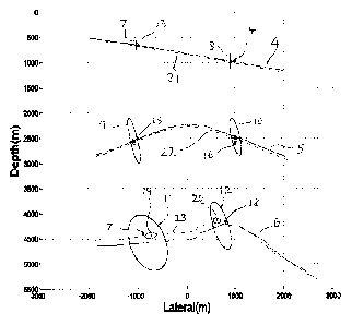
Figure 3 shows the uncertainty of two depth, east and north locations in each
layer.
These uncertainty ellipsoids 7 to 12 are obtained from traveltime data, using
no well
information at this stage. These ellipsoids are 95 percent regions, indicating
that there
is a 95 percent probability that the true reflection point is within this
ellipse. Note that
uncertainty aggregates as we go deeper and so the ellipses become bigger for
the
deepest interface. As the rays pass through an area with large dip, the
underlying
interface gets larger horizontal (east, north) uncertainty. This is natural as
the
uncertainty is highly connected to the sine of the transmission angle via
Snell's law.
CA 02705505 2010-05-12
WO 2009/062935 PCT/EP2008/065331
11
Finally, well markers are used along with their associated uncertainty. Before
updating
the structural model from seismic, we now introduce the concept of 'common
points':
these are geographical coordinates that are common for well measurements and
seismic depth, east and north coordinates. Since neither well marker data nor
the
.. points obtained from seismic data are noise free, the common points are not
known.
Nevertheless, we know that the well marker and the seismic geographical
coordinates
represent the same geological feature; thus a seismic commonpoint to a well
marker
can be chosen. We assign constraints to these common points. The constraints
are
informative about the direction in which the seismic depth, east and north
coordinates
should be updated. The constraints form a way of integrating the common points
and
all other points in the model. While the number of points can be several
thousand, the
number of common points is typically small (around 100 well markers).
The optimal estimate for geographical positions is calculated as a standard
least
squares solution, but the notion of common points and three dimensional
updating
gives an extra degree of flexibility. In particular, updating points along the
original ray
path seems intriguing. The uncertainty of all points is updated as an
intrinsic part of the
least squares methodology. This is smallest near common points since there are
two
sources of information here. It is largest far from common points and at large
depths.
In Figure 4 the well marker data are shown at 13 to 18. The common points are
updated and the integrated estimate is marked along with the uncertainty
ellipsoids,
such as 19 and 20, in Figure 4. Note that the updated uncertainty ellipsoids
(19, 20) are
smaller than the ones (11, 12) from seismic data alone as the uncertainty of
the well
picks is quite small in this case. The broken lines in Figure 4 represent the
updated
horizons 21, 22 and 23 from both seismic data and well picks. These are
somewhat
shifted from the estimated horizons 4, 5 and 6, respectively, using seismic
data alone,
but mostly locally due to a correlation window in the statistical model.
In the following, it is assumed that the image ray tracing has been executed,
so that all
fault and horizon data are converted into north, east and depth coordinates.
The
velocity model used in the image ray tracing is also present. A covariance
matrix
describing the uncertainty and the correlations (dependency) of all data,
(velocities,
spatial seismic positions and well markers), is present. For updating this
model using
well markers, statistical computation based on least squares mathematics are
used.
CA 02705505 2010-05-12
WO 2009/062935 PCT/EP2008/065331
12
The various types of constraints are described below. Any combinations of the
types of
constraints and numbers of well markers could be used. The statistical update
could be
executed in three ways.
i) An update using
all well markers in one go, selecting all common points
(described later) from the original ray traced data set.
ii) A two step update. First adjust the model using the velocity and
horizon well
markers. Then calculate the fault common points in the adjusted model, and
use these to update the well and horizon adjusted model using the fault well
markers.
iii) A sequential update. In this form, the model is first adjusted by the
well markers
belonging to the uppermost horizon and the uppermost velocity layer.
Thereafter the resulting model is used to calculate the common points for the
well markers for velocities and horizons belonging to the next layer, and
adjusted using the well markers belonging to the second layer. This process is
continued until all velocities and horizons have been traversed. The model
resulting from this process is used to calculate the common points of the
fault
well markers, and is further adjusted using the fault constraints
No matter which of these strategies is selected, uncertainty is treated in a
coherent
way through the adjustment, resulting in updated uncertainties for all inputs,
which
are derived from all input uncertainties and correlations.
Since a well marker of a horizon is only a single point position, we do not
know exactly
which seismic horizon point matches it. Assuming that the difference between
the two
common points is mainly due to inaccuracy in the interval velocities used in
the initial
ray tracing, the horizon point whose prolonged incidence ray passes closest to
the well
marker is chosen to be the matching seismic common point to each well marker.
These
two positions are thus chosen to be a common point pair as shown at 24 and 25
in
Figure 5.
To update the seismic model using a common point pair 24, 25, a constraint
between
the two points is set. As stated earlier, we do not know exactly which seismic
horizon
point matches the well marker, only that inaccuracy of the along-incidence ray
velocity
is the most likely cause for the well marker and horizon not intersecting. Due
to this
CA 02705505 2010-05-12
WO 2009/062935 PCT/EP2008/065331
13
fact, the constraint between the two identified common points is set only in
the direction
of the ray tracing incidence ray 26 of the selected horizon common point 25.
Thus, the
update from a single common point pair 24, 25 adjusts the seismic model only
in the
direction of the incidence ray at the seismic common point. This is shown in
Figure 6.
The update constraints using fault points in the common point pairs differs
slightly from
the constraints using horizon points. This is basically due to how a fault,
such as 30 in
Figure 7, is depicted in the seismic. In the original seismic data, the exact
location of a
fault is not shown; only a blurred area in the seismic data shows that a fault
is present
somewhere within that area. The seismic interpreter then does his best to
interpret the
fault into that area based on intuition and prior knowledge and experience.
For this
reason, the fault point 31 through which the corresponding fault surface
normal 32 lies
closest to the corresponding well marker 33 is chosen as the seismic point in
the
common point pair, as shown in Figure 7.
The constraint between the two common points 31, 33 is to affect only the
seismic
model in the direction of the fault surface normal 32 through the seismic
common point
31, as shown in Figure 8. The adjusted fault position is shown at 34 and the
adjusted
common point positions at 35 and 36. Other common point pairs may however
adjust
the model in other directions.
The image ray tracing uses interval velocities to convert seismic time data to
3D
positional data in north, east and depth coordinates. We are thus dividing the
full
velocity model up in sections in which neighbouring horizons are borders for
each
interval. Within each such interval, the bedrock velocity is modelled in
various ways.
For example, as shown in Figure 9a, a single velocity, such as V1 and V2, may
be
allocated to each interval, such as 40 and 41, and it is assumed that this
velocity
applies to all points within the interval. Alternatively, a respective
velocity Vij may be
assigned to each jth trace of the ray tracing within each of ith interval as
shown in
Figure 9b.
In another alternative, a set of velocities Vij may be assigned to the jth
positions or
points, in the ith intervals. The velocity at any arbitrary point may then be
found from
an interpolation function. For example, the velocity V1X at the point 42 is
given by the
interpolation function illustrated as F(V11,V12,V13,V14) in Figure 9c. The
interpolation
CA 02705505 2010-05-12
WO 2009/062935 PCT/EP2008/065331
14
function may, for example, form a weighted average of the velocities at a set
of
positions in the neighbourhood of the point.
Measurements of the bedrock velocity are also available from wells drilled
through the
modelled area. For each such velocity measurement chosen to be a part of the
adjusted model, a constraint is set up between the wellbore measurement and
the
corresponding velocity from the initial seismic velocity model. In the case
where the
interval velocity is modelled as a set of spatially fixed velocities combined
with an
interpolation function, the seismic velocity chosen is the velocity modelled
through the
interpolating function at the point chosen to match the wellbore velocity
measurement.
As shown in Figure 10, the velocities V1, V2, V3 measured during drilling
through the
region may be used in the ray tracing or may be used subsequently to update
the
seismic model by "correcting" the ray tracing. The updated horizons are shown
at 44 to
46. For the example shown in Figure 9a, the velocity in each interval may be
made
equal to a measured value, or an average of measured values, in the interval.
For the
examples shown in Figures 9b and 9c, some form of inverse interpolation
function may
be used to update the model values from the measured values.
To ensure that intersections between horizons and faults still intersect after
the
adjustment, constraints between intersecting horizon and fault points can be
added,
making sure that each selected horizon/fault point pair still intersect after
the
adjustment.
Further information about the background to and embodiments of the invention
is
provided in the following paper.
Introduction
Reliable prediction of subsurface faults and horizons is of major importance
for the
petroleum industry. Both the best estimates and the uncertainty of positions
are of high
importance in several decision processes. One such process is well planning
where
this information influences the shape of well trajectories and also the shape
and
position of drilling targets (Haarstad et al. 2002; Prange et al., 2004). The
positional
uncertainty of structures is crucial information both in planning the
acquisition of new
CA 02705505 2010-05-12
WO 2009/062935 PCT/EP2008/065331
subsurface data for better subsurface understanding, and in the process of
planning
the drainage strategy of a reservoir. Estimates of horizon and fault
positions, as well as
their uncertainties, is an important input for prediction of in place volume
estimates.
5 Today most well calibration methods rely on changing the seismic velocity
model until it
mostly fits a set of well-measured velocities. This is a time consuming
process with a
lot of human interaction. The misfit between the depth converted model and
well
markers is then corrected using Kriging methods which adjust the depth
converted
horizons to fit wells only in the vertical direction. Positional uncertainty
is similarly
10 calculated only in the vertical direction (Abrahamsen 1992; Abrahamsen
and Benth,
2001).
In several cases, the lateral positioning and subsequent uncertainty of
structures are of
importance for decisions to be made, especially in well planning. Examples of
such
15 structures are areas near and in erosion surfaces, areas close to
faults, and also where
horizons have changing DIP angle. Holden et al. 2003 extend the standard
models for
treating horizons to also include fault objects, but faults are only modelled
using objects
moveable in one dimension. In geo modelling, see e.g. (Caumon et al; 2004), it
has
been common to represent zone boundaries and update these as more data become
available. One such technique, based on triangulated surfaces, was presented
in Thore
et al. 2002, and discussed several aspects of multidisciplinary integration
and
quantification of uncertainty.
In this paper we present a new method for predicting subsurface horizon and
fault
positions incorporating lateral and depth position uncertainties with
applications to well
planning and structural model update. The approach integrates seismic
traveltime data
and well position markers, and converts these into predicted lateral and depth
positions
along with associated uncertainties and spatial correlations. Integration of
diverse data
leads to desirable properties: i) Main lateral structures are maintained in
the depth
predictions because of the large scale lateral continuity in interpreted
seismic data. ii)
Important corrections in depth uncertainty and smaller scale fluctuations are
incorporated via well picks. Since both seismic data and well data are
measured with
noise, statistical integration of both data types provides prediction that
captures the
level of uncertainty of depth and lateral positions.
CA 02705505 2010-05-12
WO 2009/062935 PCT/EP2008/065331
16
The method used in this paper is briefly described as follows. Interpreted
seismic
traveltime data are converted into depth and lateral positions using ray-
tracing (see e.g.
Hubral, 1977). Faults and horizons are treated as point objects in three
dimensions, but
the uncertainty of the fault objects might be different from that of horizon
objects due to
interpretation issues in seismic processing. Well markers correct the initial
seismic
depth model using the wellbore position measurements along with a set of
constraints
for geological boundaries. We use a Gaussian model for positions in 3D and the
corrections are made based on the modelled covariance matrices, (see e.g.
Cressie,
1993).
The outline of this document is as follows. We introduce the concept of
seismic ray-
tracing for time domain to depth domain conversion in Section 2, while the
uncertainty
calculation associated with this method is presented in Section 3. In Section
4 we
describe our proposed model for including fault points. Section 5 is dedicated
to well
updating of the subsurface model. Several options are discussed for
integrating the
well marker data. Numerical examples of the methodology are presented in
Section 6.
The mathematical details are postponed to Appendices.
Seismic Image Ray Migration
The simplest approach for converting seismic traveltime picks into depth and
lateral
positions is vertical stretch depth conversion. We then assume that time
migration has
positioned all reflectors at their correct lateral position and simply stretch
the traveltime
picks in the vertical direction using interval velocities. A more realistic
approach, which
is considered here, is to depth convert seismic traveltime picks using image
ray tracing
(map migration). A ray is then traced downwards for the time indicated by the
time
migrated data at that particular lateral location. This image ray starts along
the vertical
axis at the surface and bends at subsurface interfaces according to Snell's
law. If time
migration has been done correctly, the results after image ray tracing will
coincide with
that of more sophisticated depth migration. The aspects of seismic depth
conversion
have been discussed extensively in geophysical literature (Hubral, 1977;
Parkes and
Hatton, 1987; Black and Brzostowski, 1994;Bube et al., 2004; Kane et al.,
2004). The
method of choice depends on the geological complexity of the subsurface. The
methodology described in this document is meant for geological settings of
moderate
CA 02705505 2010-05-12
WO 2009/062935 PCT/EP2008/065331
17
complexity. This means that the simplest vertical stretch might cause bias,
but ray-
tracing supposedly is sufficiently realistic.
Suppose we have two-way seismic traveltime picks, denoted
to, k =1,K = 1,K
,m, where in is the number of picked reflecting interfaces
and nh the number of traveltime picks in each horizon. The case with different
number
of picks in various layers is possible, but requires some technical details.
We return to
this topic in chapter 0. Fixed surface locations (Nk,o,Ek,o,Dk,0), k =1,K
,no are
given as the common depth point locations (inlines / crosslines) used in time
.. processing of seismic data. (The typical case is Dk.0 =0 .) Interval
velocities
are vi,K ,vm. Positions (Nk.,,Ek,),Dki ) are geometric reflection points for
the
respective traveltime picks tk,. For the topmost geological interface, rays
are vertical
and reflection positions are represented by
N k,1= N k,0
Ekl= Ek0
, k =1,K ,nh.
Dk,1= Dko+-1 vitAi
' 2 '
which can be written in short form as
(Nk ,1 Ek,I,Dh,l) = j, [vi, V = v1,K ,v (1)
where fk,i :9r 9Z3,
keeping the surface inline and crossline locations and the two-
way seismic traveltimes fixed. Arranging all points in the top horizon
together gives a
vector:
= (N1,1, E11,D11,K , , En,j,DJ)T .
For the deeper layers / = 2,K ,in, the reflection positions are computed using
Snell's
law at interfaces. If the incidence angle with an interface is 0, and the
velocities in the
upper and lower layers are given by v1 and respectively, the transmission
angle
(v
with this interface is et = arcsin sin(e,)
. The reflection points in the lower layer
'
can then be calculated by a nonlinear function of the velocities and the
points in the
CA 02705505 2010-05-12
WO 2009/062935 PCT/EP2008/065331
18
above layers (giving the incidence angle). Geometric positions are in this way
calculated recursively, going deeper at each step. The mathematical
relationship can
be written in short form as:
= j k nõ1 I+1 m.
(2)
The details of this raytracing formulation are postponed to the Appendix. For
the
understanding of the method, it is important to note that the variables of
interest include
1) Layer velocities: V = (vi,K ,
2) Positions (north, east and depth) for all horizons: H =(h1,K ,hõõ).
These two types of variables will be used for well updating below.
Seismic Uncertainty Propagation
In this section we describe the method used for calculating the uncertainty in
depth
converted lateral and depth positions. The calculation is an elementary
exercise in
mean and covariance calculation under a linearized model. Suppose generally
that y = Ax) for some function f( ) . In our case this function A ) is built
up of
sequential ray tracing defined by equation (2). Suppose further that E is the
covariance matrix of x. The covariance matrix W of y can be approximated by
Taylor
dAx)
expansion and equalsY = FEFT , where F= is evaluated at the mean value ofx
dx
Following this scheme, the expressions in the Equations (1) and (2) can be
differentiated to give
a
F ¨ afkr,/ ,v,,(Nkj,Ekj,Dkj),1 j k ¨ ngi j
k,/ r Lvi,K ,v, i11 fl g] 5(N kj,E kj5D Aj)1 <1
5 , 5 < - k < - g a[v,h;
{ all,/ [V, hi 51 afk,/ [V, hi 51 (3)
/1 afki [V, hi 51 /11
_______________________________________ 5K 5 ___________
av ahiT
Here, many elements will be zero because the predicted geometric positions
depend
only on a few variables. We collect all columns in Equation (3) as a matrix
denoted
CA 02705505 2010-05-12
WO 2009/062935 PCT/EP2008/065331
19
byFi . Note that this matrix contains all partial derivatives when predicting
positions in
layer / from the above layers and the velocity values. This matrix is used to
construct
the covariance matrix 4' of the geometric positions in layer / obtained by ray
tracing.
The uncertainties in velocities are specified initially and the covariance is
built
.. sequentially, layer by layer. For the first layer:
_
Ev Ev.F1T
itlih,l-
F, = E,, F, = E i , = Fi -FE,,, 9
-
whereE, is the specified covariance for velocities, while E is the covariance
matrix
for traveltime picks in layer 1. We assume that the traveltime picks are
spatially
.. correlated according to their distance on the surface and this is
represented by a
spatial correlation function and a Kronecker product for,. The deeper layers
are
constructed recursively by
tp [ itli h 'P FT
= ,1 I h,li 1 /=1K in¨i. (4)
h'1+1 FliF14117,1FIT EE,1+1'
At 1+1= in we have the entire covariance matrix for all layer velocities and
geometric
positions in the model (north, east and depth).
Modelling of Faults
In this section we present the approach for integrating faults. The assessment
of fault
positions in depth coordinates and their position uncertainties can be done in
several
ways depending on the geological setting. We have focused on 'normal' faults,
i.e.
faults that dip in the direction of the horizon. For such faults we assume
that the points
that 'fill' holes in the horizons are merged into the horizons and positioned
using ray
tracing. These fault positions are referred to as 'merged' points. The
remaining fault
points are referred to as 'non-merged' points. The non-merged points are
positioned
based on the depth of merged points and on surface (inline / crossline)
positions
relative to the merged points in the seismic traveltime data. Fault position
uncertainties
are mainly assessed from the seismic error propagation, but uncertainty is
also added
based on the interpreter's prior judgements.
CA 02705505 2010-05-12
WO 2009/062935 PCT/EP2008/065331
We briefly describe the mathematical approach used for assessing the non-
merged
points, assuming that the position of merged points is reliably obtained from
ray tracing.
Based on the set of 'merged' points, the centre point(N,,E,,D, ), the dip and
the
5 azimuth of
the fault are calculated. This is obtained by simply calculating the mean of
all merged points and the principal components of the merged points. The
calculation
for principal components goes as follows: Let Wi denote the covariance matrix
of the
'merged' fault points, in North, East and Depth coordinates. This subset of
points is
defined by picking the points that are merged fault points among all points.
This matrix
10 is a sub-
matrix with indexes picked from Y. in equation (4). The principal components
defined by fl with associated singular values A are such that:
= BAIT (5)
From the principal components we can calculate the dip azimuth and dip
inclination of
the 'merged' fault points. Moreover, we use the centre point and principal
components
15 along with
the surface reference positions in the time interpretation to assign geometric
coordinates to the 'non-merged' fault points. The 'non-merged' points (Nf ,Ef
,Df )are
given by a functional relationship which in short form is:
(Nt ,Ej , Di )= ff (11,(N,,E,,De)), (6)
where the surface reference locations Ne,E,,D, in the interpreted seismic
traveltime
20 data are
treated as fixed. The function ff is in this case an inverse of the
calculation of
the principal components from the 'merged' points.
After the assessment of these fault points, the geological positions can be
represented
by G =(H,F), where II are the original horizon points without the removed
merged
fault points, and whereF are the fault points, both merged and non-merged. In
addition, an associated covariance matrix for all positions is provided. The
covariance
matrix forH is set from the ray tracing error propagation, while the
covariance matrix
forF is set using Monte Carlo simulations for this small set of fault points
based on the
Equations (5) and (6). For the fault points, we also assume that the
traveltime picking is
quite unreliable and the lateral entries are assigned a large uncertainty to
account for
this picking uncertainty of faults. We assume no cross-correlation between
horizon
pointsH and fault pointsF .
CA 02705505 2010-05-12
WO 2009/062935 PCT/EP2008/065331
21
Model adjustment based on well position markers
After the faults and horizons have been converted from the time domain into
depth
using seismic velocities, additional measurements of their positions are being
introduced to the system from borehole measurements. These additional point
based
measurements effectively reduce the uncertainty of the entire model due to
their low
uncertainty compared to the initial depth converted model. The constraining of
the
model on borehole measurements is made using a least squares adjustment
approach
based on conditional equations. All measurement errors and thus all linear
combinations of these are assumed to be Gaussian. The method is described in
detail
in App B. Derived from this method are the equations:
LL.LoBT(BEL0LoBT )-1B)L0
and
=E, ¨E, BT (BELL BELL
LL
where
Lo is the initial measurement vector
EioLo is the covariance matrix of the initial measurement vector
B is the matrix of constraining equations
L is the estimated measurement vector (constrained using the B matrix)
Ell is the covariance matrix of the estimated measurement vector, L
Every stochastic variable involved, and hence any linear combination of these,
is
assumed to be normally distributed. The vectorL consists of three types of
measurements:
= interval velocities, contained in the vector V
= point positions making up the geological surfaces, contained in the
vector G
= well marker positions used to constrain the geological surfaces, contained
in W
CA 02705505 2010-05-12
WO 2009/062935 PCT/EP2008/065331
22
Each modelled position (both well markers and the geological points) consists
of
coordinate triplets P =[N E D]T. Combining the three types of measurements
into
the common measurement vectorL , gives:
L = [V G Wr =
[v, = = = 17, N,õ EGõ D,õ === A I GSn E GSn DGSn N1 4, Dw, N. E.
D. ]T
where M is the number of velocities (and horizons) modelled, S is the total
number of
geological surfaces (horizons and faults), n is the number of geological
points in each
surface, and T is the total number of well markers. The total number of
geological
points is denoted by the letter 0.
Each row of the B - matrix consists of the coefficients of one constraining
equation, put
on the set of measurements given by Lc,. The full constraining equations are
formulated
by:
BL=O.
The rotation matrix,
ri ri 2 /13
R =[Ru Rv Rw]= r21 r22 r23 ,
r21 r32 r33
plays an important in role in the following sections. This matrix describes
the
transformation between two rotated coordinate systems with the same origin. A
point
Puvw =[u v w]described in the UVW ¨coordinate system is thus converted to the
point Pxyz = [x y z] in the XYZ ¨coordinate system through the multiplication:
= P PXYZ = RUVW--).XYZ UVW
and inversely a point in the XYZ ¨ coordinate system is transformed into the
UVW ¨
system through:
SUBSTITUTE SHEET (RULE 26)
CA 02705505 2010-05-12
WO 2009/062935 PCT/EP2008/065331
23
= P P uviv DT vpv->xyz XYZ
If we look at the individual column vectors of R = [Ru Rw],
they
.i7Y.Z
represent the unit vectors of the UVW -axes seen in the XYZ - coordinate
system.
Due to this last property, the column vectors of a rotation matrix are useful
for
specifying constraining equations in arbitrary spatial directions.
Well adjustment constrained in vertical direction
In this case, the constraints set between the D coordinates of well markers
and their
respective geological common-points are only specified in the vertical
direction. For
each pair of points a constraining equation can be formulated by:
CE(Pck)-CE(Pwi)= 0 ,
where C = [0 0 1], PG, are the coordinates of the k -th geological point in G,
and
Pm the coordinates of the/ -th well marker in the well marker vector W.
Putting these conditions into the B -matrix gives:
0 0 ACiA 0 0 A-CiA 0
1x/1/ 1x3 1x3 1x3 lx3 lx3 1x3
B1 = M M MM
o 0 A C, A 0 0 A -CT A 0
1x3 lx3 1X3 1x3 1x3 1;6
Tx(M+3=0+3=T)
Each row of the B1 matrix corresponds to the measurement vectorL =[V G WIT.
Since no constraints are specified for the interval velocities in V, the M
first numbers
of each row vector in B1 are set to 0. The next 3 0 row posts correspond to
the
geological points in G, 0 being the number of geological points in G. The
three row
posts matching to the geological point, Gk'P in G are set to the vector Ck ;
the rest of
CA 02705505 2010-05-12
WO 2009/062935 PCT/EP2008/065331
24
the posts matching to G are set to 0. The last 3=T posts of each row in B1
correspond to the well markers in W, where T is the number of well markers
included.
Of these, only the three posts matching to the well marker pr are filled in
with the
vector¨ C, , whereas the rest of the posts are set to 0. The total number of
rows in
B, equals the number of constraints T.
Well adjustment constrained along surface normal
To set a constraint perpendicular to the geological surface in the vicinity of
a certain
geological common-point, the eigenvector of the n closest points to the common-
point
are used, specified through the rotation matrix R:
(- - T
ri 1 1'12 r13 N, ¨ N A Nõ ¨ N -N1¨N A Nri ¨ N
R=[Rõ R R,]= ril r22 r23 = eig E1¨E A Eõ¨E = El¨E A En¨E
_r21 r32 r33 _ D,¨D A Dõ¨D D,¨D A Dõ¨D
_ _
In the following it is assumed that the eigenvectors are sorted in such a way
that R, is
the eigenvector corresponding to the smallest belonging eigenvalue. R, is an
approximate unit vector perpendicular to the geological surface. Thus
multiplying R,T with an arbitrary vector gives the component of the arbitrary
vector in
the direction ofR,.
Using this we can formulate a condition between a pair of common- points as:
RwT(E(PGk) WW1)) =
wherePõ are the coordinates of the k -th geological point in G, and Põ the
coordinates of the/-th well marker in the well marker vector W .
Combining several conditions into a common matrix, B1 , gives
CA 02705505 2010-05-12
WO 2009/062935
PCT/EP2008/065331
0 0 A RwiT A 0 0 A ¨R,vi T A 0
1x11/ 1x3 1x3 1x3 1x3 1x3 1x3
= M M M MM
0 0 A R,,T A 0 0 A T A 0
IxM lx3 1x3 lx3 lx3 lx3 lx3
Tx(M+3=0+3=T)
which correspond to the measurement vector L = [V G WIT. The M first numbers
of
each row vector in B1 are set to 0, followed on each row the 3.0 numbers
corresponding to the geological points in G, M being the number of interval
velocities
5 in V and 0 being the number of geological points in G. The three row
posts matching
to the geological point, PG,' in G are set to the vector ; the
rest of the posts
matching to G are set to 0. The last 3 . T posts of each row in B1 correspond
to the
well markers in W, where T is the number of well markers included. Of these,
only the
three posts matching to the well marker Pm are filled in with the vector¨ R1,
whereas
10 the rest of the posts are set to 0. As we specify one constraint for
each well marker
included, the total number of rows in B1 is equal to T.
Well adjustment constrained in image ray direction
15 .. In this case, the constraints between the coordinates of the common
points (i.e. well
markers and geological points) are set in the direction of the incident angle
of the ray
trace. This constraint can be expressed by:
E(r - Xg Yw -
Yg Z¨ Zg iT) = E(ri(X,,õ ¨ Xg ) + r2 (Y, ¨Yg) + r3 (Zõ ¨ Zg ))= 0
where r = [r1 r2 r3]T is the unit vector of the incident ray on the surface,
(XYZ),, and
(XYZ)9 are the coordinates of the well markers and geological points
respectively.
The above mentioned constraint can be expressed by the following matrix:
CA 02705505 2010-05-12
WO 2009/062935 PCT/EP2008/065331
26
0 0 A rikT A 0 0 A ¨r1IT A 0
1xM 1x3 1x3 1x3 1x3 1x3 1x3
= M M M MM
0 0 A ruT A 0 0 A ¨rill' A 0
1xM 1x3 lx3 1x3 1x3 1x3 1x3
TO+30+3T)
where the indexes k and 1 correspond respectively to the points PG, and /3 of
the L
vector. T is the number of common point pairs.
Constraints between faults and horizons
Constraints between faults and horizons can be added to make horizon and fault
crossings fit together also after update. For a single pair of points
consisting of a
horizon point and a fault point, such a condition is stated as:
/E (Pin, ) ¨ IE(P,1)= 0,
stating that the horizon point PHA on the border between a horizon and a fault
shall be
identical to the corresponding fault point P.
.
Similar fault- fault intersection constraints can be stated as.
IE(13,1)¨ IE(Pn)= 0
Sets of such constraints can be added to the B -matrix forming the
constraining
equation set:
B = L =[131= IL= G
[B2]
where
CA 02705505 2010-05-12
WO 2009/062935 PCT/EP2008/065331
27
0 0 A /1 A 0 0 A ¨11 A 0
3xM 3x3 3x3 3x3 3x3 3x3 3x3T
B2 = M M M MM M M.
0 0 A Is A 0 0 A ¨Is A 0
3x/v/ 3x3 3x3 3x3 3x3 3x3 3x3T
3T4M+3=0+3=T)
Each row of the B2 matrix corresponds to the measurement vectorL = [V G WIT.
The first M posts of each row as well as the last 3. Tare set to 0, since
interval
velocities and well markers are not included in these constraints. M is the
number of
interval velocities, and T is the number of well markers. For each horizon and
fault
point pair, there are three constraining equations; their coefficients are
represented by
two3x3 unit matrices in B, . Making the total number of rows in B2, 3 .S . S
is the
number of horizon/fault point pairs.
Picking of common points
As mentioned earlier, the least squares adjustment is based on setting
constraints
between wellmarkers and geological points. The wellmarker and the geological
point
constitute a common point. For a given wellmarker, the method for choosing the
best
suited geological point may depend on the applied constraining principle.
In this section, four methods for picking of common points will be presented.
Three of
these methods are especially suited for the constraining principles disclosed
hereinbefore. The fourth method may be applicable for all constraining
principles.
1.1.1 Constraint in vertical directions
When constraints between well marker and geological points are to be set in
the
vertical direction, the geology point with the closest lateral Euclidian
distance to the well
marker is used as common point. The lateral distance dh is calculated by:
dh =(N ¨ NG)2 (E, ¨ EG)2
CA 02705505 2010-05-12
WO 2009/062935 PCT/EP2008/065331
28
where Nw and NG denote the north coordinates of the wellmarker and the
geological
point respectively.
1.1.2 Constraints along surface normal
As geological common point in this case, the geological point that lies
closest to the
approximate geological surface normal through the well marker is used. To
calculate
this distance, we need to transform both geology points and well marker into a
coordinate system in which one of the axes lies along the surface normal. This
is done
using the eigenvectors of the n closest geology points to the surface as
rotation matrix,
to transform between the NED- coordinate system and the- UVW system, in which
the
W direction lies along the surface normal. The rotation matrix is calculated
as follows:
- - - - T
N,-N A N-N N,-N A N,,-N
R("VW -)TIFT) = [R,, Rv 1?,]= eig E,-E A Eõ-E = E,-E A Eõ-E ,
D, -D A D-D D, -D A Dõ-D
_ _
Where
R T
RNED- = >UVW UTzif ->NED
It is assumed that the column vectors of RNED,, are sorted in such a way that
the R, vector is the eigenvector corresponding to the smallest eigenvalue. In
the
transformations the midpoint PG of the n closest geology points to the well
marker, Pw ,
is used as origin for the UVW- coordinate system.
Thus the transformations of arbitraryPG and P, points into the UVW system are
formulated as:
U G
PG ,UVW = G = R NED->UVIV (PG NEV P )
W
_ G _
CA 02705505 2010-05-12
WO 2009/062935 PCT/EP2008/065331
29
and
Uw
Pw.uvw = Vw =RATEn-uvw(Pw, ArEv PG )
Ww
The perpendicular distance duv between the surface normal through the well
marker
and the various geological points is then calculated by the formula:
duv = II(Uw¨UG)2 +(Vw ¨VG)2
1.1.3 Constraints in image ray direction
A suitable geological point can be found by comparing the perpendicular
distances
between the actual wellpick and all the nearby incident ray traces of the
geological
points. The geological point corresponding to the perpendicularly closest ray
trace will
then be the candidate for common point.
The following approach can be used to find the shortest perpendicular distance
between a wellpick and the nearby incident ray traces. First, a subset of the
closest
geological points to the wellmarker is found by comparing horizontal
coordinates. Then,
we have to calculate the shortest perpendicular distance from the wellpick to
every unit
ray-trace vector.
Let the wellmarker and the geological point be denoted by:
Pw = [Xvv Yw Zvv] and PG = [XG YG ZG]
The vectorW' from the wellmarker Pw to the geological point PG is given by:
= [Xw - XG Yw -YG Zw -ZG1
CA 02705505 2010-05-12
WO 2009/062935 PCT/EP2008/065331
The perpendicular distance D from the wellmarker to the unit vector Yof the
incident
ray trace is simply the length of the cross product of Iw' and This
length can be
calculated by:
5
The above-mentioned procedure has to be repeated for all the wellmarkers in
the
actual area.
10 1.1.4 "Most likely" geological common point
This method uses the uncertainty ellipsoids of the well marker and geological
points to
decide the "most likely" geological common point. A weighted distance measure
is
calculated by:
dweighrea = V(Pw PG )* inv(Ew G) (1:14, PG)T
The summation of the covariance matrix L. of the well marker and the
covariance
matrix EG of the geological point is possible since the original seismic
interpretation is
assumed to be uncorrelated with the well marker.
Well marker uncertainty model
The coordinates of the wellmarkers are important input. Another important
input is the
variances of the coordinates of the wellmarkers and the covariances between
them. A
wellbore consists of several survey points and some of these survey points are
chosen
as wellmarkers.
The coordinates of wellmarkers are calculated from directional surveys and
measured
depths performed at several stations along the wellbore. The directional
surveys are
correlated between survey stations. This is also the case for the measured
depths.
These correlations should be taken into account to ensure a proper variance
and
covariance matrix propagation.
CA 02705505 2010-05-12
WO 2009/062935 PCT/EP2008/065331
31
Modelling of variances and covariances of wellmarkers
Depth measurements are a significant contributor to the wellbore position
uncertainty
when surveying both with magnetic and gyroscopic instruments. Correlations
between
depth measurements are considered to be the most important correlation in
wellbore
surveying. Another source to strong correlations is the declination error.
A detailed overview of the most important error sources in depth measurements
is
given in Ekseth, R 1998. The following procedure is found appropriate to
investigate of
the effects of depth correlations.
For prediction of the correlation behaviour of depth measurements between
survey
points along the wellbore, a correlation function may be used. A correlation
function
can for instance be expressed in terms of an exponential function:
D.-D.
p = e
where pij is the correlation coefficient, is the
a suitable correlation length, and D,
and Di are the measured depth in unit metres at the points i and j
respectively. The
correlation length is
defined as the length needed for the correlation between two
wellmarkers to fall below a certain value.
The covariance sa. between the wellmarkers i and j can be predicted by the
following
formula:
2 2 2
6 = p G
1J 1J n JJ
where pij is the correlation coefficient, andcsi, and jj are
the variances of the
wellmarkers number i and number j, respectively.
References
CA 02705505 2010-05-12
WO 2009/062935 PCT/EP2008/065331
32
Abrahamsen, P., 1992, Bayesian Kriging for seismic depth conversion of a multi-
layer
reservoir, In Proc. From 4th geostatistical conference, Troia 1992.
Abrahamsen, P. and Benth, F. E., 2001, Kriging with inequality constraints,
Mathematical Geology (33), 719-744.
Black, J. L. and Brzostowski, M. A., 1994, Systematics of time-migration
errors,
Geophysics (59), 1419-1434.
Bube, K. P., Kane, J. A., Nemeth, T., Medwedeff, D., and Mikhailov, 0., 2004,
The
influence of stacking velocities uncertainties on structural uncertainties,
Society of
Exploration geophysicists, Expanded Abstracts (23), 2188-2191.
.. Caumon, G., Lepage, F., Sword, C. H., and Mallet, J. L., 2004, Building and
editing a
sealed geological model, Mathematical Geology (36), 719-744.
Cressie, N. 0. C., 1993, Statistics for spatial data, Wiley.
Haarstad, I., Lotsberg, 0., Torkildsen, T., and Munkerud, P. K., 2002, Target
design
based upon multidisciplinary uncertainty information, Society of Petroleum
Engineers,
SPE 74460.
Holden, L., Mostad, P., Nielsen, B. F., Gjerde, J., Townsend, C., and Ottesen,
S., 2003,
Stochastic Structural Modeling, Mathematical Geology (35), 899-913.
Hubral, P.: Time migration ¨ some ray theoretical aspects, Geophysical
Prospecting
(25), 738-745.
.. Kane, J. A., Rodi, W., Bube, K. P., Nemeth, T., Medwedeff, D., and
Mikhailov, 0.,
2004, Structural uncertainty and Bayesian inversion, Society of Exploration
geophysicists, Expanded Abstracts (23), 1511-1514.
Parkes, G. and Hatton, L., 1987, Towards a systematic understanding of the
effects of
velocity model errors on depth and time migration of seismic data, First Break
(5), 121-
132.
Prange, M. D.., Tilke, P. G., and Kaufman, P. S., 2004, Assessing borehole-
position
uncertainty from real-time measurements in an Earth, Society of Pertroleum
Engineers,
SPE 89781.
Thore, P., Shtuka, A., Lecour, M., Ait-Ettajer, T., and Cognot, R., 2002,
Structural
uncertainties: Determination, management and applications, Geophysics (67),
840-
852.
Ekseth, R 1998. Uncertainties in Connection with the Determination of wellbore
positions, 1998. Doctoral thesis 1998, Norwegian University of Science and
Technology. ISBN
CA 02705505 2010-05-12
WO 2009/062935 PCT/EP2008/065331
33
Torkildsen T.,2006, Method of combining spatial models, US Patent 7149672 B2
Alkhalifa T.,Larner K., 1994, Migration error in transversely isotropic media,
Geophysics (59), 1405-1418
App A Image ray tracing
Image raytracing is defined by starting a ray vertically at the surface and
applying
Snell's law at interfaces. At every interface of two horizons /and 1+1, and
for every
point k = 1,K , nh the following is needed for raytracing:
1) The unit vector of the incidence ray:
(NA,/ ¨ Nk,1-1 9 Ekd ¨Ek,1-1 9 Dkd DA.,1-1)
UkI = _______________________________________________________ (Al)
11(1\ k,1 N k,1-1)2 ( ( Ek ¨ ,1 Ek,1-1 Dk ¨,1 Dk,1-1
2) The unit normal vector at point k of interface 1:
uk,n = _____________________________________________________________ (A2)
0, +a, +1
where
(0,0 ¨ 5)(Nj,i ¨ /V)
L(A LI ¨M2
JEa
a = leak
(A3)
L(E ¨E)2
/ea
=A/LI,= LEP, 5 = L D1,1*
jE ak jE ak jIk
and a is a specified neighbourhood of point k.
3) The incidence angle at pointk of layer!:
= arccos(uk,nu), (A4)
where
110,110 =210,(0=Iik,i (1) + uk,, (2) uk,i (2) uk.n (3). uk,i (3). (A5)
4) The transmission angle at point k into layer/ +1 calculated using Snell's
law:
CA 02705505 2010-05-12
WO 2009/062935 PCT/EP2008/065331
34
[ sin (0 A .,i)V 1+11
k ,t = arcsin ______________________________________________________ (A6)
Vi
5) The transmission unit vector at point k into layer 1+1:
V11 \ v1+1 f \
=+ cos0 ____ cos9k ,n 9 (A7)
Vi
where the scalar coefficients in front of uk,, and Uk,n are evaluated by
ensuring
that
cos(ek,t )= Uk,õUkT
(A8)
uk,t 11=1,
is valid, that sin2(0)=1¨cos2(e) and Snell's law in Eqn. (10).
6) The predicted point k in layer 1+1:
1
N A.,1+1= Nk,1 tk,1)14A,t(1)
1 I
E k ¨ V i_FiVk ,1+1 tk,1)14 k .t (2) 5 k =1,K
,N , (A9)
' 2
1 = D k' + ¨2V 1+1k(
t k .1+1 t k ,1)111k,t (3)
where components of the transmission unit vector are given by
14k,, = kik,t(1)514k.t (2), uk,, (3)] =
Steps 1)-6) described in Eqn. (5-13) can be written in short form as:
(Ark,i+1,-Ek,I+1)Dk,I+1 = f k,I[V1,1( ,vm,(xk,ph,pzk,, ),1 j 7,1 k nil
(A10)
where the function fk,, :9C-F3'h Vsummarizes all the relationships.
App B Deduction of the least squares adjustment formulas
B.1 Definitions
Measured values: L =[11,12,13 ..
CA 02705505 2010-05-12
WO 2009/062935 PCT/EP2008/065331
The measurement errors are considered to be normal distributed, and therefore
all
linear combinations of these are also normal distributed.
p, 0 0 ...
0 p2 0 ...
Measurement weights: PH=
0 0 p3
=== === === ===
5
-
Cofactor matrix: Qõ ¨ õ
If the measured values are weighted using their initial measurement
uncertainties then
LL PLL 1 ¨ LL where Eõ denotes the initial covariance matrix of the measured
10 values.
Unknowns: X = , x2, x3 ..
Residuals: c =LLte ¨
Model: AX¨=c, which gives c = AX¨F where F=L+c. c is a constant
vector. In statistical terms from [2]:
E[L] =AX¨c ; E{(L ¨ E ILAL ¨ MDT = EH,
Condition equation: BX ¨We = 0, where We is a constant vector.
Error propagation law: If we have the model y = Ax then Qs5, = AQ,AT
B.2 Generating normal equations
Using the condition equation, we can construct the help function h, in which
the
weighted sum of squares is conditioned on the condition equation, using
Lagrange
multipliers:
CA 02705505 2010-05-12
WO 2009/062935 PCT/EP2008/065331
36
h =ET PõE +2K(BX ¨We)
K is a vector of Lagrange multipliers. Filling in for c gives:
h= XT AT PõAX ¨ 2AT PõFX + FT PõF + 2K(BX ¨Wc.)
Using the derivatives of the help function with respect on the unknowns K and
X, we
can create a set of normal equations containing the least squares estimates of
K and X
as unknown sizes:
= o AT Pil,AI ¨ AT PõF +134 =0
ax
ah
¨ = o =0
c)K
Rearranging the normal equations into a matrix equation, gives a
straightforward way
to calculate X and K:
[Xµ- _[A1 PõA PõF-
K B 0
_
Using the error propagation law, the cofactor matrix for X and K becomes:
[Q Qs,,,,11AT PõA BT1 AT PõA OT AT PõA BT -1
Q xk Q kk L B 0 0 OiL B
B.3 Direct calculation of the estimate for X
As it is only X and Q, we are interested in, it opens for direct calculation
of these.
Starting with:
CA 02705505 2010-05-12
WO 2009/062935
PCT/EP2008/065331
37
AT PõAI¨ AT PõF +BT k =0,
we substitute AT (Põ)A with No, and rearrange equation to:
= No-lATPõF¨ Aro'BTk
Substituting for X in:
B2t ¨W, =0,
gives:
K =GoivolBT YlaVol AT PõF ¨ (BN0 'Br )-1W,.
Substituting this result into the equation for X, gives:
= NolATPõF¨NolBT(BN01BT)-1BNolATPõF+NolBT(BN01BT)-'W.
B.4 Direct calculation of the estimate for Clxx
Applying the error propagation law on:
= No 1 AT PõF ¨ Ar 01 BT (B11101 BT )-1 BA 01 AT PõF + le (BlVole) W,
gives:
Qk)-(= No' ¨N01BT(BN0113T)1BN0l.
B.5 The statistical model: X-L=0.
CA 02705505 2010-05-12
WO 2009/062935 PCT/EP2008/065331
38
Looking at the statistical model: AX ¨ L = c, which gives c = AX ¨ F where
F=L-Fc. cis a constant vector. It can be easily transformed into the
model X ¨ L =0 , by setting A = I , and c = el", which leads toF = L , and No
= PLL=
We still want to keep the condition equation: BX ¨W, = O.
Applying these changes to:
= No lATP,LF ¨No 1/3T (BN0 1/3T)-1BN0 lATPLLF +No 1/3T(BN0 1BT)-'Wc.
gives:
= L 11IT )-1 BL+ Põ 1BT (BPõ 'Br )-1TY,.
And applying them to:
Q1c,,c = No ¨ No IBT ON 01 BT BN 01 ,
gives:
Q = PLL-1 - PH-1 BT (BPLL-1 BT )-1 BPLL-1 =