Note: Descriptions are shown in the official language in which they were submitted.
CA 02705618 2010-05-27
1
METHOD FOR MONITORING A SUBSOIL ZONE, PARTICULARLY
DURING STIMULATED FRACTURING OPERATIONS
Field of the invention
The invention relates to a method for monitoring a
subsoil zone by detecting microseismic events.
The invention relates more specifically to a
method for monitoring stimulated fracturing performed
in a well.
State of the related art
Stimulated fracturing operations are intended to
increase the productivity of a hydrocarbon reservoir
working well.
These operations consist of injecting a high-
pressure fluid into a layer of the subsoil where the
reservoir is located. The injection of the fluid
produces microfractures in the layer. This technique
makes it possible to increase the permeability of the
reservoir by favouring hydrocarbon circulation via the
microfractures to the well.
However, these operations require continuous
monitoring of the reservoir so as, on one hand, to
monitor the progress of the fracturing operation and,
on the other, stop the operations when the fracturing
is sufficient.
Known monitoring techniques make use of the fact
that the microfractures generated in the layer induce
micro-earthquakes which are propagated and can be
detected by means of receivers.
CA 02705618 2010-05-27
2
Document W02008/033797 describes a monitoring
method wherein the seismic receivers are arranged on
the soil surface. The subsoil zone to be monitored in
divided into a plurality of cells. An expected travel
time between each cell and each receiver is then
calculated using a subsoil velocity model. The seismic
signals received by the receivers and recorded by the
recorder (referred to as "traces") are corrected to
account for the differences in expected travel times
between one cell and each of the receivers, and the sum
calculated. The summed data (referred to as "source"
data) are analysed to detect the presence of a possible
(or "triggering") event characterised by a large
amplitude and high energy parameters.
The monitoring method described in this document
does not enable rapid data processing, and is not
suitable for real-time subsoil monitoring.
Document US7391675 describes a real-time
monitoring wherein the seismic receivers are arranged
in a well, which may be either the producing well or
another well. The method consists of migrating the
seismic data recorded to perform continuous mapping of
the subsoil, on the basis of a predictive travel time
model of the waves P and S in the subsoil, and
detecting a time of a location corresponding to a
maximum coalescences associated with the occurrence of
an event.
One drawback of this method is that it is
necessary to install receivers inside a well, which
complicates the installation and increases the cost. In
addition, if the receivers are installed in the
CA 02705618 2010-05-27
3
injection well, the well tends to vibrate under the
effect of this injection, which raises the noise level
on the receivers positioned in this well. It is not
always possible to have access to another well.
Furthermore, the following documents describe the
use of a perforation shot to calibrate a velocity model:
- SPE 115722, Denver, 21-24 September 2008,
"Velocity Calibration for Microseismic Monitoring:
Applying Smooth Models With and Without Perforation
Timing Measurements", Pei et al., and
- EAGE Workshop on Passive Seismic, Limasol, 22-25
March 2009, A-l3, "Dual Treatment Monitoring with
Horizontal Receiver Array", Michaud et al.
Description of the invention
One aim of the invention is to propose a
monitoring method enabling rapid detection of a
microseismic event.
According to a first aspect, the invention
envisages a method for monitoring a subsoil zone by
means of a plurality of seismic receivers arranged on
the soil surface or near said surface, comprising the
following steps:
- generating a set of reference seismic data,
- recording seismic data by means of said
receivers,
- correlating the seismic data recorded with the
reference seismic data,
- comparing each correlated data trace with
correlated traces located in a vicinity of said trace,
CA 02705618 2010-05-27
4
in order to evaluate a similarity of each correlated
trace with the adjacent correlated traces,
- detecting a microseismic event occurring in the
subsoil zone by analysing said similarity.
The proposed method offers the advantage of
enabling real-time processing of the seismic data
acquired.
According to another aspect, the invention
envisages a method for monitoring a fracturing
operation in a well by means of a plurality of seismic
receivers arranged about the well on the soil surface
or in the vicinity of said surface, comprising the
following steps:
- generating a set of reference seismic data
following a perforation shot in the well,
- recording the seismic data by means of said
receivers,
- correlating the seismic data recorded with the
reference seismic data,
- comparing each correlated data trace with
correlated traces located in a vicinity of said trace,
in order to evaluate a similarity of each correlated
trace with the adjacent correlated traces,
- detecting a microseismic event occurring in the
subsoil zone by analysing said similarity.
In addition to the fact that it enables real-time
processing, the proposed method uses a perforation shot
in the well to generate reference seismic data. This
offers the advantage of not requiring the use of a
velocity model. Indeed, the seismic data acquired
following a perforation shot serve somewhat to
CA 02705618 2010-05-27
characterise the subsoil zone and replace the use of
the velocity model.
The correlation of the seismic data recorded
during the fracturing operation with the reference data
5 produces correlated data showing the presence of a
potential microseismic event.
Description of figures
Other features and advantages will emerge from the
description hereinafter, which is purely illustrative
and non-limitative, and must be read with reference to
the appended figures, wherein:
- figure 1 represents schematically an example of
an installation to perform stimulated fracturing
operations in a working well,
- figure 2 is a diagram representing schematically
the steps of a first phase of the monitoring process,
enabling the acquisition of reference data,
- figure 3 represents schematically raw reference
seismic data, as recorded following a drilling blast,
- figure 4 represents schematically, the reference
seismic data after correction of the estimated
propagation time,
- figure 5 represents schematically, the reference
seismic data, after filtering,
- figure 6 represents schematically the steps of a
second phase of the monitoring process, enabling
detection of microseismic events,
- figure 7 represents schematically raw seismic
data, as recorded during stimulated fracturing
operations,
CA 02705618 2010-05-27
6
- figure 8 represents schematically correlated
data obtained by correlating recorded seismic data with
the reference seismic data,
- figure 9 represents schematically a recording
device and a proximity zone determined about a given
seismic trace,
- figure 10 is a diagram representing for each
recorded trace, a trace similarity parameter with the
traces recorded in the associated proximity zone.
Detailed description of an embodiment
In figure 1, the installation is deployed on a
hydrocarbon (gas or oil) production site 1. The site 1
comprises a subsoil zone, comprising geological
layers 11, 12, 13. The layer 13 is a layer containing
hydrocarbons. The site 1 comprises a well 14 drilled
through the geological layers to the layer 13.
The installation also comprises a fracturing
device 2 and a monitoring device 3.
The fracturing device 2 comprises a fluid
injection column 21 extending into the well 14 and a
pumping unit 22 positioned on the surface 15 of the
subsoil zone.
The injection column 21 comprises a lower end 211
provided with openings 212 and an upper end 213
equipped with a well head 214 connected to the pumping
unit 22.
The pumping unit 22 comprises a pump 221 suitable
for injecting a high-pressure fracturing fluid 222 into
the layer 13 via the injection column 22. The
CA 02705618 2010-05-27
7
fracturing fluid typically consists of a mixture of a
liquid (water) and particles (sand).
The fracturing fluid is injected via the pump 221
into the column 21 via the well head 214, circulates in
the column 21 and is discharged from the column via
openings 212 created by well casing perforations. The
fracturing fluid enters the subsoil layer 13, inducing
fracturing of the layer 13, i.e. the appearance of
cracks inside the layer 13. The particles contained in
the fracturing fluid are forced into the cracks and
remain in place in the cracks when the fluid pressure
is released, thus forming a permeable network enabling
hydrocarbon to flow in the layer 13 to the well 14.
The monitoring device 3 comprises a network 31 of
receivers (geophones), a recording unit 32 and a
processing unit 34.
The receiver network 31 comprises a plurality of
receivers 33 arranged on the soil surface 15 or in the
vicinity of said surface. The receivers 33 may be
arranged on the nodes of a grid as in figure 9, but may
be arranged in any other configuration.
The soil movements detected by the receivers 33
are converted into electric voltages transmitted to the
recording unit 32 to be recorded therein. The
recordings obtained represent the seismic data (or
traces).
The processing means 34 include calculation means
programmed to perform the steps of the monitoring
method using the seismic data.
The monitoring method is performed in two
successive phases:
CA 02705618 2010-05-27
8
- a first phase (preparatory phase) consisting of
generating the reference data, prior to the stimulated
fracturing operation, and
- a second phase (monitoring phase) enabling real-
time detection of microseismic events during the
stimulated fracturing operation.
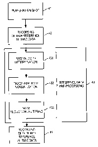
Figure 2 is a diagram representing schematically
the step of a possible implementation of the first
phase of the monitoring process.
According to a first step 41, a perforation shot
performed in the well to create openings 212 is used,
as specified above, as a source of seismic waves. Such
a source may be characterised as an isotropic point
source (explosive source) located at a point S0
(referred to as "perforation point"), in the vicinity
of the subsoil zone to be monitored. The coordinates {x,
y and z} of this source are generally known. Knowledge
of the specific time of the explosion is not necessary
for the proper operation of the process. The subsoil
zone to be monitored is the zone of the layer 13 and
surrounding layers where microseismic events will be
likely to occur due to the injection of fracturing
fluid in the layer 13. At the time of the perforation
shot, a seismic wave occurs which is propagated in the
layers of the subsoil to the receivers 33.
According to a second step 42, the receivers 33
generate seismic signals or "traces". The set of traces
generated by the receivers form raw reference seismic
data (data represented in figure 3). These raw
reference seismic data are recorded in the recording
unit 32.
CA 02705618 2010-05-27
9
According to a third step 43, the raw reference
seismic data are pre-processed by the processing unit
34. This third step 43 comprises several sub-steps 431
to 433 for filtering the raw reference seismic data.
According to a first sub-step 431, the processing
unit 34 determines an RMS (Root Mean Square) velocity
which maximises the sum of the traces contained in the
seismic data.
The determination of the RMS velocity makes it
possible to correct the seismic data to compensate for
the differences in wave travel time to reach the
various receivers. The corrected data are reduced to a
common reference, which is the perforation point
(corrected data represented in figure 4).
According to a second sub-step 432, the processing
unit 34 normalizes the amplitudes of the various traces
to compensate for the differences in amplitudes between
the traces, due to the differences in source-receiver
distances.
The normalization sub-step 432 consists of
dividing the amplitude of each trace by an RMS (Root
Mean Square) amplitude, the RMS amplitude being defined
as the root mean square of the amplitudes of the trace
samples.
According to a third sub-step 433, the processing
unit 34 filters the data to reduce the noise contained
therein. The data filtering may include so-called
"mute", F-K (Frequency - Wavenumber) filtered, F-X
(Frequency - Trace number) filtering, median filtering
or subtraction operations.
CA 02705618 2010-05-27
According to a fourth step 44, the filtered
reference seismic data (filtered data represented in
figure 5) are stored in the memory of the processing
means 34 in the form of a file referenced:
5
Perfo0(t, Rc)
where t refers to the propagation time and Rc the
receiver in question.
10 In some cases, records capable of providing
reference data of sufficient quality are not available.
In this case, it is possible to replace the first
reference data recording and filtering phase by a
reconstruction of these data by means of methods well-
known in the field of seismic processing (DIX formula,
ray tracing, finite difference model, etc.) which all
assume knowledge of a propagation model consisting of
propagation parameters (velocities, attenuations,
static corrections) in the zone above the zone to be
monitored.
The reference seismic data obtained by means of
the first phase of the method will be used during the
second subsequent real-time monitoring phase of the
fracturing operation.
Figure 6 represents schematically the steps of the
second phase of the monitoring process, enabling
detection of microseismic events occurring during the
fracturing operation, i.e. during the injection of
fracturing fluid in the subsoil.
According to a first step 51, the receivers 33
convert the subsoil movement into electrical signals
CA 02705618 2010-05-27
11
transmitted to the recording unit 32 to form the basic
microseismic data file represented in figure 7 and
referenced:
D(8, Rc)
where e refers to the calendar time and Rc to the
receiver in question.
According to a second step 52, the basic seismic
data are correlated with the reference seismic data.
The correlated seismic data obtained (data
represented in figure 8) are recorded in the form of a
file referenced:
CC(B, Rc) = D(O, Rc) O Perfo0(t, Rc)
where OO refers to the correlation product.
The correlated seismic data are in the form of a
wavelet signalling the possible presence of a
microseismic event, said wavelet having the following
properties:
- the arrival times corresponding to the maximum
amplitudes (maximum energies) do not vary much from one
receiver to adjacent receivers,
- the phase distortions created by the superficial
layer WZ (Weathered Zone) are reduced or eliminated by
the correlation operation,
- the polarity of the wavelet is spatially stable
but may change according to the observation zone.
According to a third step 53, the similarity of
each correlated trace with the adjacent correlated
CA 02705618 2010-05-27
12
traces is evaluated. This third step 53 comprises
several sub-steps 531 to 533.
According to a first sub-step 531, each seismic
data trace CC(6,Rc) is correlated with the sum of the
traces contained in a vicinity of said trace.
C0(8, Rc) = CC(e, Rc) O S(8, Rc)
where S(8, Rc) = Y CC(B, Rc)
RcEV
where S(6) is the sum of the traces contained in a
vicinity V, the vicinity V being defined as a disk
having a radius Rd centred on the trace in question.
Figure 9 represents the distribution of the
receivers about the well and a vicinity V having a
radius Rd centred on the trace in question.
This correlation step makes it possible to compare
each trace with the close environment thereof, by
eliminating the polarity inversion problem between the
traces. Indeed, the correlation operation demonstrates
a similarity between the traces despite the presence of
inverted polarity peaks (whereas a summing would result
in the traces cancelling each other out). This step is
performed in time windows. The best results are
obtained when the windows fully overlap except for a
single sample. For each correlation, it is only
necessary to calculate a restricted number of points
about the time 0, or even the single sample at the time
0.
CA 02705618 2010-05-27
13
According to a second sub-step 532, a semblance
parameter S1(9) is calculated a sum of filtered seismic
data C1(O, Rc) :
S1 (9) = Y C1(0, Rc)
Rc
This sum may be a simple sum, a weighted sum
(referred to as "diversity stack") or a median.
The semblance parameter S1(O) measures the overall
similarity of the CC traces with the surrounding CC
traces. After normalisation, this parameter is an
indicator of the presence of a microseismic event.
Figure 10 is a diagram representing the value of
the semblance parameter SI(B) as a function of the
calendar time 9 . In this diagram, the presence of a
peak indicating the occurrence of a microseismic event
in the time window in question is observed.
According to a fourth step 54, the processing
unit 34 detects a microseismic event on the basis of
the semblance parameter.
According to a first option, the processing
unit 34 detects the occurrence of a microseismic event
when a local peak of the semblance parameter is greater
than a predefined threshold value (set to 10 in figure
10).
According to a second option, the processing unit
34 detects the occurrence of a microseismic event when
the ratio between a local peak of the semblance
parameter and the RMS amplitude of the corresponding
sample is greater than a predefined threshold value.
CA 02705618 2010-05-27
14
According to a third option, the processing
unit 34 detects the occurrence of a microseismic event
when the ratio between a local peak of the semblance
parameter and a mean value of the local peaks, an RMS
value or a median of the local peaks is greater than a
predefined threshold value.
According to a fourth option, the processing
unit 34 performs a statistical search in the local peak
curve. For example, the processing unit 34 searches for
a discontinuity in an ordered sequence of peaks.
The monitoring method described, while it is of
particular value for monitoring a stimulated operation,
is not limited to this application and is applicable
more generally for monitoring a subsoil zone.