Note: Descriptions are shown in the official language in which they were submitted.
CA 02707070 2010-06-23
METHOD AND APPARATUS FOR NETWORK PLANNING
TECHNICAL FIELD
The present invention generally relates to network planning
and more particularly to handling vector data for wireless network
planning.
BACKGROUND
Wireless communications systems are used to satisfy a variety
of mobile voice and data communication needs. Currently, there is
demand for additional wireless capabilities so that customers can
expand their use of wireless communication devices. This demand is
forcing wireless service providers to expand their networks at a rapid
rate. The mobility of wireless communication users complicates the
deployment of additional network infrastructure such as base
stations.
Wireless networks are complex because the infrastructure is
often spread over large geographic regions, wireless signals are
CA 02707070 2010-06-23
-2-
attenuated as a function of distance, and wireless traffic is not evenly
distributed over the served region (e.g. wireless traffic is often
clustered into defined areas such aS along roadways). Network
engineers model wireless networks before deploying system
s hardware to ensure complete signal coverage and adequate channel
capacity. Currently, computer based planning tools are used to
perform the complex computations necessary for modelling a
wireless network. These models use digitized map databases,
geographic coordinates, terrain data, and feature data in an attempt
1o to account for important design constraints. However, the use of
digitized map databases undesirably limits the accuracy of
computerized network planning.
Since digital maps represent sampled data, there is a spacing
between adjacent sample points. The area between each sample
1s point is referred to as a map pixel. The size of each map pixel varies
based on the sample spacing used. For example, the area of each
map pixel is approximately 90 meters north-south by 70 meters east-
west for a 3 arc second USGS map, which is normally used for wireless
network planning. Current planning tools use the map pixel as the
20 smallest unit of reference; therefore, features smaller than a map
pixel in one dimension are not accurately interpreted. Several types
of features used in wireless network planning are smaller than a map
pixel in one dimension. Accurately modelling the distance to these
CA 02707070 2010-06-23
-3-
features is desirable. Features smaller than a map pixel in one
dimension are normally referred to as vectors, with roads and county
boundaries being among the most common vector types
encountered in wireless network planning.
Fig. 1 illustrates a road 104 traversing map pixels 102. The
shaded pixels indicate how the road is perceived after it is rasterized.
It can be seen in Fig. I that the road value is attributed to the entire
pixel even though the road only touches a portion of the pixel.
Attributing the road attribute to the entire pixel introduces errors.
io The errors introduced by using map pixels as the smallest
measurement unit are especially problematic when performing
propagation loss calculations to points located along a vector. For
example, if a car is on a narrow road running through the middle of a
map pixel, a propagation calculation to the road can only be
computed to an edge of the map pixel containing the road. In
addition, other information such as elevation and land-use-land-cover
(LULL) are averaged across the entire map pixel, further introducing
errors. Thus, the road 104 is not modeled accurately enough to
achieve optimum results.
Therefore, a need exists for more accurately computing
distances to points along vectors when performing network
planning. Furthermore, computing the distance to vector features
CA 02707070 2010-06-23
-4-
should not overly burden data storage systems by generating
excesshI data points.
SUMMARY
It is an advantage of the present invention that a system and
method are provided for incorporating the accuracy of vector data
into network planning without incurring the penalties realized when
all pertinent data is treated with the same granularity. The disclosed
invention makes it possible to perform accurate distance dependent
propagation loss calculations to vector features located within map
1o pixels. Furthermore, the present invention surpasses current art
methods when modelling transient roadway events, such as traffic
jams.
The above and other advantages of the present invention are
carried out in a network planning system where many input and
output variables are required and computed. Variables are stored in
data planes which are indexed by geographical location. The use of
data planes makes it possible to store non-vector data and vector
data with separate granularities while using a single geographical
coordinate system. Some examples of non-vector data which are
also common to vectors are base elevation and terrain. Data common
to vectors and non-vectors is only stored in a single data plane. In
contrast, variables unique to each data type are stored in the
respective data planes. An example of a variable unique to vector
CA 02707070 2010-06-23
.5-
data planes is width. Keeping unique variables in the respective data
plane ensures that other processes, such as display system processing
and computations, can determine when a specific variable should be
accounted for.
BRIEF DESCRIPTION OF THE DRAWINGS
A more complete understanding of the present invention may
be derived by referring to the detailed description and the claims
when considered in connection with the Figures, wherein like
1o reference numbers refer to similar items throughout the Figures,
and:
Fig. 1 - is an illustration showing a prior art method of rasterizing a
road;
Fig. 2 - is an illustration of data planes as used by the present
invention;
Fig. 3 - illustrates a method for identifying map pixels using a unique
identifier;
Fig. 4 - is an illustration of a comprehensive display created using data
planes;
Fig. 5 - is an illustration showing generation of vectors on data planes;
Fig. 6 - is an illustration showing superposition of vector points on a
grid of map pixels;
CA 02707070 2010-06-23
-6-
Fig. 7 - illustrates a flow diagram of steps used in wireless network
planning;
Fig. 8- is an illustration showing radial signal paths for map pixel
display;
Fig. 9A and 9B - illustrate a pixel representation of a propagation path
loss calculation;
Fig. 10 - illustrates a flow diagram of a method for computing
propagation loss;
Fig. 11 - is an illustration of a representative apparatus for
performing invention;
Fig. 12 - provides a map showing road orientations;
Fig. 13A and 13B - illustrate the use of vector data; and
Fig. 14 - is an illustration showing propagation losses for various road
orientations.
DETAILED DESCRIPTION
A typical wireless network consists of at least one base station
(BSS), or cell site, associated with a specific geographic location within
the service area. Cell sites can be further divided into macro cell or
micro cell sites depending on the antenna height and area served.
The present invention can be used for planning macro and micro
cells; however, descriptions of the invention and preferred
embodiments will be discussed in the context of the more general
CA 02707070 2010-06-23
-7-
macro cells. Often a BSS contains more than one antenna in order to
serve a larger area. When more than one antenna is used, each
antenna serves a particular area, known as a sector, around the BSS
location. In situations where signals from more than one antenna
reach a particular location within the BSS service area, the antenna
producing the stronger signal at the measured location is referred to
as the best server.
Maps
Line-of-sight (LOS) from BSS to mobile receiver is required for
to signal reception; therefore, network planners must take into account
terrain features, land-use-land-cover (LULL), population density,
foliage, etc. Since BSS locations, mobile receiver locations, elevations,
and land use features can be uniquely identified by geographic
location, representing these features of interest on geographic maps
is convenient. Rasterized maps are used to display feature data on a
general purpose computer system using the disclosed method. Any
type of rasterized map database can be used; however, for cellular
network planning most network planners use the USGS 3 arc second
database. The 3 arc second database provides a reasonable
compromise between database size and geographic location
resolution. Rasterized maps consist of sampled data with the area
between each sample point referred to as a map pixel. A map pixel is
the smallest unit of resolution for a given set of digitized map data.
CA 02707070 2010-06-23
As previously noted, each map pixel is approximately 90m N-S x 70m
E-W for a 3 arc-second raster map.
When performing computerized wireless network planning, it
is helpful for planners to have a comprehensive display capability so
s that various information types can be displayed simultaneously. For
example, a comprehensive display allowing the network planner to
view BSS locations, terrain features, population density, and road
locations at the same time allows the planner to quickly comprehend
the results of a given network configuration. The present invention
io produces comprehensive displays by creating multi-dimensional
maps. The multi-dimensional maps are produced by manipulating
multiple data types (variables) relative to a reference to produce a
meaningful display.
Raster Data Planes
15 Fig. 2 illustrates raster data planes, hereinafter referred to as
data planes, as used by the present invention. Data planes are used
to produce multi-dimensional maps. Typically, data planes are
comprised of regularly arranged points corresponding to a
rectangular grid. These data planes are assigned such that each
20 variable is represented by a single plane. Some data planes may
contain input variables such as elevation 204, land cover 206, and land
use 208 which are required to compute a radio plan. Others data
planes contain output variables such as best server 210, and received
CA 02707070 2010-06-23
-9-
power 212. Additionally, a user can create data planes containing
other user-defined variables as needed to facilitate a given wireless
planning task. To minimize storage requirements, variables common
to more than one data plane are only stored in one of the data
planes. For example, if the elevation variable is used by both a road
data plane and a terrain data plane, it will only be stored in one data
plane and made accessible to other data planes requiring the
information.
Fig. 3 illustrates a technique used in the present invention for
1o identifying map pixels using unique points. Unique points are used to
identify map pixels in the following discussion, however persons
knowledgeable in the art will readily comprehend that other
methods can be used to identify map pixels without departing from
the spirit of the disclosed invention. Fig. 3 contains uniform map
pixels 312, 314, 316, and 318. Note that the south-west corner of each
map pixel has been selected as the unique identification point. Using
the southwest corner to identify each map pixel produces the
following relationships: corner 302 is used to identify map pixel 312,
corner 308 is used to identify map pixel 318, and corner 304 is used to
identify map pixel 314.
Exemplary Display Using Data Planes
Fig. 4 presents a representative display requiring the use of
multiple data planes. A base station 400 is shown having three
CA 02707070 2010-06-23
-10-
antennas which form three sectors having best server areas 402, 404,
and 406, respectively. The land use within the entire served area 412
is uniform except for water body 408. In addition, futures of
interest, namely roads 410 and 414 are shown. Although multiple
data planes are used to represent the data, overall accuracy of
network planning is not enhanced without additional processing.
The mere use of data planes does not enhance accuracy because all
data such as LULC, population density, and wireless traffic density are
represented as an average value for an entire map pixel. For
1o example, a single point located on highway median strip would have
the same population density value as the inhabited areas adjacent to
the highway if resolution is limited to the area of a map pixel.
The present invention makes it possible to accurately compute
the distance to, and properties of, intra-pixel features. The
foregoing discussions will detail correct processing of vector data;
however, it will be apparent to those skilled in the art that the
techniques disclosed herein can be used on other intra-pixel features
without departing from the spirit of the invention.
Vectors Generally
Fig. 5 illustrates the definition of a feature as a set of points
connected by straight lines. A vector 516 was created by connecting
points 519, 520, 522 and 524, respectively. Data storage requirements
associated with vectors are optimized by storing the minimum
CA 02707070 2010-06-23
-11-
number of points required to adequately represent the particular
vector. For example, if a vector feature makes a tight turn, the
points used to denote it will be close together 518. For a vector
feature that runs straight, the points can be far apart 516.
To accommodate vector features of varying width, a separate
input variable is used to specify the width of the vector feature. In
general, the database used to store vector features is smaller in size
than the map pixel database because most map pixels will not
contain roads, land boundaries, or other features which are
io represented by vectors. However, if vector features are complex,
the vector database can be made larger to accommodate more
detail than is required for storing map pixels.
Vectors and Data Planes
The variables associated with vectors are organized as a set of
is webbed data planes, as shown in Fig. 5, one plane per variable. Three
data planes are shown in Fig. 5, namely coordinate 528, relative
elevation 530 and best server 532, when the same coordinate system
is used for both the map pixel data planes and the vector data
planes, vectors can be visually and logically superimposed for both
20 display to the network planner and for computer calculations. When
practicing the disclosed invention, there is no requirement that the
granularity of the vector and map pixel planes be coordinated.
CA 02707070 2010-06-23
-12-
Fig. 6 shows a superposition of two vector points 602 and 610
on a grid of map pixels 604. There is no need to store a vector point
at map pixel 606 or 608 because points 602 and 610 are connected by
a straight line. Any vector values needed for calculations within those
map pixels can be derived by interpolation. For instance, if the
vector points represent a road that is 10m above the surrounding
terrain, the elevation of the road in map pixel 606 will be 10m above
the terrain of that pixel. Accurately representing vector features is
critical to producing realistic wireless network plans using
io computerized planning systems.
Exemplary Steps for Wireless Planning
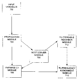
Fig. 7 shows the major steps used for wireless network
planning. Here it is noted that additional steps can be added to the
diagram of Fig. 7 without departing from the spirit of the disclosed
invention. Step 702 uses input variables, including geographic data
and user specified operating constraints. The information inputted
in step 702 is used by a propagation module (step 704) to compute
the expected signal strength at each map feature, including vector
features. The propagation calculation is performed at least once for
each base station in the coverage area. If vector features are not
present in a particular pixel, traditional raster processing is
performed. When one or more vector features are present in the
pixel being processed, the vector processing as disclosed herein is
CA 02707070 2010-06-23
-13-
used. The output of the propagation module (step 704) feeds the
best server module (step 706). The best server module (step 706)
selects the base station that should be serving each map pixel. In the
event that more than one base station is serving a particular map
pixel, the best server module (step 706) selects the base station
producing the strongest signal at the map pixel and assigns the
received signal to that base station. The output of the propagation
module (step 704) and the best server module (step 706) are inputted
to the pairwise Carrier-to-Interference (C/I) module (step 708). The
output of the C/I module (step 708) is inputted to the frequency
assignment module in step 710. The frequency assignment module
(step 710) performs the assignment of frequencies to particular
channels within the network. In Fig. 7, best server module (step 706)
is shown outputting data to probable neighbor module (step 712).
The dashed line connecting the output of step 712 to step 710 is used
to indicate that the respective connection can be eliminated if
desired.
Propagation Loss Generally
An important result of wireless network planning is the
determination of expected signal-to-noise ratios for all possible
mobile receiver locations within the service area. As previously
mentioned, accurately predicting the distance dependent
propagation loss to locations within the service area is essential to
CA 02707070 2010-06-23
-14-
producing an accurate wireless plan. Many methods exist for
computing the propagation loss; however, a generalized form can be
written in dB units as
Preceiver = Ptransmit + Gbase - L + Gmooiie ; Eq. 1
s where Preceiver = power at the mobile receiver
Ptransmit = transmit power of the base station
Gbase = base station antenna gain
L = propagation path loss, a positive quantity
Gm = mobile station antenna gain
Ptransmit, Gbase, and Gm are design quantities. As such, Ptransmit, Gbase, and
Gm can be chosen by the network designer.
Propagation path loss, L, is computed for a particular base
station to mobile receiver geometry. A general equation for the
propagation path loss at a particular receiver location can be written
as
L = Lbasic + Lobstacie - Gsiope - Gwater + Lrain ; Eq. 2
where L= total propagation path loss at a particular receiver
location
Lbasic = computed losses using a basic propagation model
Lobstacie = loss attributable to obstacles in the LOS path
between the base station and receiver
GSio;._ = gain attributable to terrain slope at receiver
location
CA 02707070 2010-06-23
-15-
Gwater = gain attributable to water's surface in vicinity of
receiver
L(afn = loss attributable to rain falling in LOS path between
base station and receiver
Lbasic has the largest impact on the final result. Lbasic represents the
LOS distance dependent propagation loss as the transmitted signal
travels through air. Several types of models are known and used in
the art to compute Lbasic such as the Longley-Rice and Okumura-Hata
models, and any of them can be used with the present invention.
Since Lbasic is distance dependent, it is important that the network
designer accurately identify the distance between the base station
location and potential mobile receiver locations for every point
within the wireless network area.
Radial Signal Paths
Fig. 8 shows multiple radial signal paths represented on a map
pixel background 800. The disclosed method makes it possible to
compute the actual distance from a BSS to any point on a vector,
thus producing increased accuracy for the distance dependent
propagation calculation. Computing propagation loss begins with
establishing radials from a BSS to a desired location pixel. Radials are
shown in Fig. 8 as paths 804, 806, 808 and 810. The radials are traced
along straight lines emanating from the BSS 802 to various mobile
antenna locations. The map pixel background, or alternatively pixel
CA 02707070 2010-06-23
-16-
map, can be thought of as a grid with the radials approximated by a
sequence of map pixels 812 and 814.
The path loss calculations are very complex and time
consuming; therefore, techniques are employed to minimize
computation times. For example, the result of each raster path loss
calculation is saved as a map pixel output variable. once the path loss
for a particular map pixel has been calculated and stored, it will not
be recomputed if another radial passes through it. Instead the
stored value will be used again for subsequent radials passing
1o through that pixel.
Variables Used in Propagation Modelling
After the radials are computed against the map pixel
background, input variables and calculation parameters are used to
further enhance the path loss calculation associated with each map
is pixel. The variables for each map pixel are retrieved from the
appropriate data planes. Some examples of common input variables
and calculation parameters are shown in Table 1; however, other
input variables and calculation parameters can also be used.
Input/pixel Calculation Parameters
Terrain Elevation Model To be Used
Location Transmitter Height
Land Use/Cover Mobile Antenna Height
Attenuation for Land Use Frequency
Average Height for Land Resolution Desired
CA 02707070 2010-06-23
-17-
Use
Height of Obstacles Window width for
Effective Antenna
Height
Orientation of Road Pixels Window width for
Average Land Use
Road Orientation
Angle Tolerance
Table 1
Propagation Path Loss Calculation Inputs
Exemplary Propagation Loss Geometry
s Fig. 9A and B illustrate the relationships for some of the
parameters identified in Table 1. In Fig. 9A, a base station (BSS) 902
having an antenna height 903 sits at a particular elevation. The BSS
elevation is computed as an average of the elevation of map pixels
906 surrounding the location of BSS 902. A mobile unit 904, having a
io mobile antenna height 905 is located a radial distance 901 away from
base station 902. The attenuation factor selected is based on the
land use at the mobile unit's location. The land use at the mobile
unit's location is calculated using the land use average window 908
and a weighting function 910.
15 It may be helpful for the reader to visualize the radial distance
901 as a profile shown in Fig. 9B. The profile is achieved by taking a
planar slice perpendicular to the earth's surface passing through
both the base station 902 and the mobile unit 904. BSS 902 is
CA 02707070 2010-06-23
-18-
positioned at location 914 having an elevation 912. The area from 914
through 915 steps up in elevation and has land cover #1. The land
cover transitions to land cover #3 at map pixel 916. Mobile unit 904 is
positioned at 922 at an elevation 924. Land cover #3 extends from
map pixel 916 to map pixel 920 where the mobile antenna 904 is
positioned at distance 901. There is a computable LOS distance 926
between the BSS 902 and the mobile antenna 904.
Exemplary Method for Computing Propagation Loss
Fig. 10 presents a flow diagram showing a preferred method
io of computing the propagation path loss and the corresponding
received power. In step 1000, the process retrieves the calculation
parameters to be used such as the maximum radius from the base
station (BSS). For each base station, the process initializes to a
starting radial, step 1002. The process starts with closest map pixel,
step 1004. Step 1006 determines if the map pixel is within the
maximum radius, and if so, the process further determines if the
received power for that pixel has been computed for this base
station, step 1003. If the receive power has not been calculated for
the pixel of interest, then the process computes the path loss for the
map pixel of interest using the selected model, step1008. Next, the
received power is computed in step 1009 and the result is stored in
the output variable data plane, step 1010. If the receive power has
been computed, the process increments out along the radial in step
CA 02707070 2010-06-23
-19-
1012 and repeats. The process then increments the radial an
additional pixel, and returns to step 1004.
When the process reaches the limit in step 1006, it checks to
ensure that all radials required for the particular base station have
s been calculated, step 1014. If not, the angle of the radial is
incremented, step 1016, and the propagation path loss for the pixels
in the next radial are calculated. When calculations are completed
for one base station, the process computes the necessary values for
the next base station, step 1018. The process repeats until
calculations have been performed for all relevant base stations
within the selected coverage area.
To account for the overlap of base station service areas, the
process is further enhanced to account for instances where the
received power from one base station is recorded for a map pixel
is that can also be served by a second base station. Once the received
power from the second base station is calculated, the two possible
powers are compared. The larger value is stored as the received
power from the best server, while the second largest is retained
elsewhere in the database.
Exemplary Apparatus for Practicing Method
Fig. 11 generally illustrates a computerized wireless network
planning apparatus 1100 capable of performing the required
operations necessary to practice the invention. Processor 1102 may
CA 02707070 2010-06-23
-20-
be any type of conventional processing device that interprets and
executes instructions. Main memory 1104 may be a random access
memory (RAM) or a similar dynamic storage device. Main memory
1104 stores information and instructions executed by processor 1102.
Main memory 1104 may also be used for storing temporary variables
or other intermediate information during execution of instructions
by processor 1102. ROM 1106 stores static information and
instructions for processor 1102. It will be appreciated that ROM 1106
may be replaced with some other type of static storage device. The
1o data storage device 1108 may include any type of magnetic or optical
media and its corresponding interfaces and operational hardware.
Data storage device 1108 stores information and instructions for use
by processor 1102. Furthermore, main memory 1104, ROM 1106, and
storage device 1108 can reside locally within the wireless network
planning apparatus 1100, or they can reside remotely. If main
memory 1104, ROM 1106 and storage device 1108 reside remotely,
data necessary for proper operation of the wireless network
planning apparatus 1100 will be communicated via a coupling means
such as an Internet, intranet, telephone line, or wireless
communications signal. sus 1110 includes a set of hardware lines
(conductors, optical fibers, or the like) that allow for data transfer
among the components of the computerized wireless network
planning apparatus 1100.
CA 02707070 2010-06-23
-21-
The display device 1112 may be a cathode ray tube (CRT), LCD, or
the like, for displaying information to a user. Alternatively, the
display device 1112 can be omitted and any interim or final data
normally displayed to an operator, can be sent to another output
device such as a printer or hard disk. Keyboard 1114 and cursor
control 1116 allow the user to interact with the wireless network
planning apparatus 1100 while performing network planning. The
cursor control 1116 may be, for example, a mouse. In an alternative
configuration, the keyboard 1114 and cursor control 1116 can be
to replaced with a microphone and voice recognition means to enable
the user to interact with the wireless network planning apparatus
1100.
Communication interface 1118 enables the wireless network
planning apparatus 1100 to communicate with other devices/systems
is via any communications medium. For example, communication
interface 1118 may be a modem, an Ethernet interface to a LAN, or a
printer interface. Alternatively, communication interface 1118 can
be any other interface that enables communication between the
wireless network planning apparatus 1100 and other devices or
20 systems.
Execution of the sequences of instructions contained in
memory 1104 causes processor 1102 to perform the method as
illustrated in Fig. 10, and the methods described hereinafter. For
CA 02707070 2010-06-23
-22-
example, processor 1102 may execute instructions to perform the
functions of propagation loss for roads, genern of vector
features, and display of interim and final results. It will be obvious to
practitioners in the art, that hard-wired circuitry may be used in
s place of, or in combination with, software instructions to implement
the present invention. Thus, the present invention is not limited to
any specific combination of hardware circuitry and software.
Propagation Loss for Vectors
When roads and other vectors are rasterized using prior art
methods, the entire pixel containing a road is given a land use of
open/road. It is known in the art that the attenuation factor for a
road is equivalent to open space and less than that of other land
cover types. When a road parallels a radial drawn from a base
station, there is a path of low attenuation along the road. For a
parallel radial, the low attenuation path can be many pixels in length.
In contrast, if the road is perpendicular to the radial, only one map
pixel will have the lower attenuation factor. In actual network
planning, it is unlikely that a road will be perfectly parallel to a radial;
therefore, for the disclosed invention parallel is defined as within a
specified angle of deviation from the radial. Typically, a radial can
deviatelo -20 from the angle of the road is still considered parallel
CA 02707070 2010-06-23
-23-
to the road; however, angles outside the 10-20 range can also be
used.
Fig. 12, shows a map portion in which the road is both parallel
to, and perpendicular to the radial emanating from the base station
1200. A road 1202 runs across Fig. 12 and passes along side base
station 1200. Radial 1206 emanates from base station 1200 and runs
toward the upper right corner of Fig. 12. Radial 1206 runs parallel to
the road segment 1212, and it runs perpendicular to road segment
1214 which is located above the tip of radial 1206. Radial 1204 runs in
1o a southerly direction and is parallel to road portion 1216. In flat
terrain, a mobile unit located at the arrowhead of 1204 will have a
clear line of sight to the base station, while a mobile at arrow head
1206, will likely be obstructed by the clutter along the radial such as
buildings and trees. If standard map pixel resolution processing is
used for propagation loss calculations, inaccurate results may be
obtained.
Use of Vector Features
The present invention avoids the accuracy limitations
encountered in network planning using pixel level resolution by
using vector features and modifying calculations accordingly. When
the propagation path loss to a vector feature is calculated, the raster
propagation path loss model is refined to accommodate the greater
accuracy of the vectors. This enables other parameters such as
CA 02707070 2010-06-23
-24-
incremental (intra-pixel) elevation, incremental (intra-pixel)
coordinates for features, and fine road resolution to be used when
making propagation loss calculations. For example, the incremental
elevation of a feature is added to the terrain elevation to provide a
new mobile antenna height, the co-ordinates and resolution of the
feature are also used to calculate the propagation path loss to the
feature and to modify the land use average distribution to account
for the placement of the vector. Using these additional parameters
results in a more accurate solution.
Fig. 13A and B illustrate the change in accuracy obtained using
vector data and the disclosed method. In Fig. 13A, a base station
signal 1306 is incident upon a mobile antenna 1302. The mobile
antenna 1302 is located on road 1304 within map pixel 1338 where
the land use average window (processing window)1340 uses 5 map
is pixels 1330, 1332, 1334, 1336 and 1338. If vector features are not
employed in the calculation, then for situations where the road is not
parallel to the radial, map pixel 1338 is recognized as road, and the
improved attenuation of a road is factored into the land use average
distribution as a complete pixel 1342. Since roads are normally much
narrower than a map pixel, errors are introduced.
When the disclosed method is employed, as shown in Fig. 13B,
the mobile antenna 1302 is placed in the center of the road 1304 at
an elevation equal to the terrain elevation plus the vector elevation
CA 02707070 2010-06-23
-25-
increment. Next, the weighted road attenuation factor is only
applied to the half of the road width 1314 that is facing the base
station. In order to maintain a processing window 1340 of 5 map
pixels in length, the remaining map pixel width 1316 is averaged in as
the low weight higher attenuation partial pixel.
Fig. 14 illustrates a road 1401 that is essentially perpendicular to
radials 1402 - 1406 emanating from a base station 1420. After 1406,
the road 1401 bends until it is essentially parallel to a radial extending
to points 1412 through 1414. Computing the propagation path loss
1o for perpendicular road points on radials 1402 - 1406 will be done as
described above. In contrast, the propagation path loss for point
1414 uses the road attenuation factor for all the pixels along the
vector and therefore shows significantly less signal attenuation at
point 1414 than at point 1406. if the loss at a point between 1412 and
is 1414 is required, say point 1416, it can be determined by
interpolating between points 1412 and 1414. For vectors,
determining whether a vector is parallel to a radial is accomplished
by comparing the angle of the vector to the angle of the radial.
After the propagation path loss is calculated, the received power can
20 be calculated using Eq. 1, shown previously.
Although the preferred embodiments of the invention have
been illustrated and described in detail, it will be readily apparent to
those skilled in the art that various modifications may be made
CA 02707070 2010-06-23
-26-
therein without departing from the spirit of the invention or from
the scope of the appended claims. For example, propagation loss
parameters can be incorporated to better account for weather
conditions, the size and shape of structures, vehicle density, etc. In
s addition, the system and method can be used to deal with aircraft on
flight paths rather than vehicles on roads.