Note: Descriptions are shown in the official language in which they were submitted.
CA 02713948 2013-08-20
50866-103
1
INTEGRATING FIELD DATA
CROSS-REFERENCE TO RELATED APPLICATIONS
[0001] This application claims priority pursuant to U.S. Provisional
Patent
Application No. 61/026,394 (Attorney Docket No. 09469/136001; 94.0188)
entitled "System and Method For Performing Oilfield Production Operations,"
filed February 5, 2008 in the names of Randy J. Vaal and Daniel Lucas-
Clements
BACKGROUND
[0002] Geographic formations are often analyzed to determine the presence
of
subterranean assets, such as valuable fluids or minerals. Fields are developed
within these geographic formations using field operations, such as surveying,
drilling, wireline testing, completions, production, planning, and analysis.
Information (e.g., data) obtained from both field operations and geographic
formations is used to assess the underground formations, and this information
is used to drive field operations to locate and, if applicable, extract the
desired
subterranean assets. Such data may be static or dynamic. Data may be
obtained and used for current or future operations. When used for future
operations at the same or other locations, such data may be referred to as
historical data.
[0003] Data from one or more wellbores may be analyzed to plan or predict
various outcomes at a given wellbore. There are usually a large number of
variables and large quantities of data to consider in analyzing field
operations.
It is, therefore, often useful to model the behavior of the field operation to
determine a desired course of action. Techniques have been developed to
model the behavior of various aspects of field operations, such as geological
structures, downhole reservoirs, wellbores, surface facilities as well as
other
CA 02713948 2015-05-08
50866-103
2
portions of the field operation. Typically, there are different types of
simulators for different
purposes. For example, there are simulators that focus on reservoir
properties, wellbore
production, or surface processing.
[0004] Typically, simulators are designed to model specific behavior
of discrete
portions of the wellbore operation. Due to the complexity of field operations,
most simulators
are capable of evaluating a specific segment of the overall production system,
such as
simulation of the reservoir. Simulations of portions of the wellsite
operation, such as
reservoir simulation, flow through the wellbore or surface processing, are
usually considered
and used individually. A change in any segment of the production system,
however, often has
cascading effects on the upstream and downstream segments of the production
system. For
example, restrictions in the surface network may reduce productivity of the
reservoir.
SUMMARY
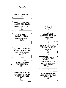
[0005] An example method of integrating field data that includes
obtaining the field
data associated with a field and performing a production analysis on the field
data to generate
a production output, the production analysis performed by a production
engineering tool. The
method further includes transforming the field data to obtain transformed
field data requested
by a field application and sending the transformed field data from the
production engineering
tool to the field application, the field application performing a field
analysis using the
transformed field data to generate a field output. The method further includes
generating a
comparison of the production output and the field output.
[0005a] According to one aspect of the present invention, there is
provided a method of
integrating field data, comprising: obtaining the field data associated with a
field comprising a
well; storing, by a product engineering tool (PET), the field data associated
with the field in a
field repository, wherein the PET comprises a field analysis tool, a field
transform engine, a
field catalogue, and the field repository; performing, by the field analysis
tool of the PET, a
production analysis on the field data to generate a production output, wherein
the production
output comprises a first production forecast for the well; displaying, by a
field application
CA 02713948 2015-05-08
50866-103
2a
separate from the PET and external to the PET, a dialog corresponding to a
plug-in of the field
application operatively connected to the PET; receiving, by the plug-in and
through the dialog
displayed by the field application, a user request for a transformation of a
plurality of field
data elements; sending, by the plug-in of the field application, a request
message
corresponding to the user request to the PET; determining, by the PET and in
response to the
request message, a plurality of locations in the field repository storing the
plurality of field
data elements by accessing the field catalogue; determining, by the PET and in
response to the
request message, a mathematical formula for the transformation by accessing
the field
catalogue; transforming, by the field transform engine of the PET and in
response to the
request message, the plurality of field data elements to obtain transformed
field data, wherein
transforming the plurality of field data elements comprises: performing a time
shifting
transformation on the plurality of field data elements to align a production
trend of the well to
a well transformation event of the well; and applying the mathematical formula
to the
plurality of field data elements; sending, by the PET and in response to the
request message,
the transformed field data to the plug-in of the field application;
populating, by the plug-in, a
plurality of data members of the field application with the transformed field
data; generating,
by the field application, a field output by performing a field analysis using
the transformed
field data, wherein the field output comprises a second production forecast
for the well; and
generating a comparison of the first production forecast and the second
production forecast,
wherein the comparison is used to adjust a field operation in the field and
increase extraction
of oil, gas, and/or water from the well.
[0005b1 According to another aspect of the present invention, there is
provided a
system for integrating field data, comprising: a computer processor; a field
application
executing on the computer processor and configured to display a dialog and
perform a field
analysis on transformed field data to generate a field output comprising a
first production
forecast for a well; a production engineering tool (PET), external to the
field application and
separate from the field application, for obtaining the field data associated
with the field,
comprising: a field repository storing field data associated with a field
having a field operation
CA 02713948 2015-05-08
50866-103
2b
and comprising the well; a field analysis tool configured to perform a
production analysis on
the field data to generate a production output comprising a second production
forecast for the
well; a field catalogue storing a plurality of locations of a plurality of
field data elements in
the field repository; and a field transform engine configured to generate, in
response to a
request message, the transformed field data, wherein generating the
transformed field data
comprises performing a time shifting transformation on the plurality of field
data elements to
align a production trend of the well to a well transformation event of the
well; and a plug-in
added to the field application and configured to: receive, through the dialog
displayed by the
field application, a user request for a transformation of the plurality of
field data elements;
send a request message corresponding to the user request to the PET; and
receive the
transformed field data from the PET for the field application, wherein the
first production
forecast and the second production forecast are compared to generate a
comparison, and
wherein the field operation in the field is adjusted based on the comparison
to increase
extraction of oil, gas, and/or water from the well.
[0005c] According to still another aspect of the present invention, there
is provided a
non-transitory computer readable medium storing instructions for integrating
field data, the
instructions comprising functionality to: obtain the field data associated
with a field
comprising a well and having a field operation and a well; store the field
data in a field
repository of a production engineering tool (PET); receive a request message
associated with
the field data from a plug-in added to a field application, wherein the field
application is
external to the PET and separate from the PET, wherein the request message
identifies a
transformation and a plurality of field data elements, and wherein the request
message is
issued by the plug-in in response to a user request received by the plug-in
through a dialogue
in the field application; access, in response to the request message, a field
catalog to determine
a plurality of locations of the plurality of field data elements in a field
repository; perform,
using the PET, a production analysis on the field data to generate a
production output
comprising a first production forecast for the well; transform, using the PET
and in response
to the request message, the plurality of field data elements to obtain
transformed field data
requested by the field application, wherein transforming the plurality of
field data elements
comprises performing a time shifting transformation on the plurality of field
data elements to
CA 02713948 2015-05-08
50866-103
2c
align a production trend of the well to a well transformation event of the
well; send the
transformed field data from the PET to the plug-in of the field application,
wherein the field
application performs a field analysis using the transformed field data to
generate a field output
comprising a second production forecast for the well; and generate a
comparison of the first
production forecast and the second production forecast, wherein the comparison
is used to
adjust the field operation for the field and increase extraction of oil, gas,
and/or water from the
well.
[0006] Other aspects of integrating field data will be apparent from
the following
description and the appended claims.
CA 02713948 2010-08-03
WO 2009/099753
PCT/US2009/031442
3
BRIEF DESCRIPTION OF DRAWINGS
[0007] So that
the above recited features can be understood in detail, a more
particular description, briefly summarized above, may be had by reference to
the embodiments thereof that are illustrated in the appended drawings. It is
to
be noted, however, that the appended drawings illustrate only some
embodiments and are therefore not to be considered limiting of its scope, for
this disclosure may admit to other equally effective embodiments.
[0008] FIGS. 1.1
to 1.4 illustrate simplified, schematic views of a field having
subterranean formations containing reservoirs therein, the various field
operations being performed in which one or more embodiments of integrating
field data may be implemented.
[0009] FIG. 2
illustrates a schematic view of a field having a plurality of
wellsites in which one or more embodiments of integrating field data may be
implemented.
[0010] FIG. 3
illustrates a system in which one or more embodiments of
integrating field data may be implemented.
[0011] FIG. 4
illustrates a production engineering tool of the system shown in
FIG. 3 in which one or more embodiments of integrating field data may be
implemented.
[0012] FIGS. 5
and 6 illustrate methods for integrating field data in accordance
with one or more embodiments.
[0013] FIGS. 7.1
to 7.2 illustrate various examples being performed by a
system in which one or more embodiments of integrating field data may be
implemented.
[0014] FIG.
8 illustrates a computer system in which one or more embodiments
of integrating field data may be implemented.
CA 02713948 2010-08-03
WO 2009/099753
PCT/US2009/031442
4
DETAILED DESCRIPTION
[0015] One
or more embodiments are shown in the above-identified figures and
described in detail below. In describing the embodiments, like or identical
reference numerals are used to identify common or similar elements. The
figures are not necessarily to scale and certain features and certain views of
the
figures may be shown exaggerated in scale or in schematic in the interest of
clarity and conciseness.
[0016]
FIGS. 1.1 through 1.4 shows a field (100) having geological structures
and/or subterranean formations therein. As shown in these figures, various
measurements of the subterranean formation are taken by different tools at the
same location. These measurements may be used to generate information
about the formation and/or the geological structures and/or fluids contained
therein.
[0017]
FIGS. 1.1 through 1.4 depict schematic views of a field (100) having
subterranean formations (102) containing a reservoir (104) therein and
depicting various field operations being performed on the field (100). FIG.
1.1
depicts a survey operation being performed by a seismic truck (106.1) to
measure properties of the subterranean formation. The survey operation is a
seismic survey operation for producing sound vibration(s) (112). In FIG. 1.1,
one such sound vibration (112) is generated by a source (110) and reflects off
a
plurality of horizons (114) in an earth formation (116). The sound
vibration(s)
(112) is (are) received in by sensors (S), such as geophone-receivers (118),
situated on the earth's surface, and the geophone-receivers (118) produce
electrical output signals, referred to as data received (120) in FIG. 1.
[0018] In
response to the received sound vibration(s) (112) representative of
different parameters (such as amplitude and/or frequency) of the sound
vibration(s) (112). The data received (120) is provided as input data to a
computer (122.1) of the seismic recording truck (106.1), and responsive to the
input data, the recording truck computer (122.1) generates a seismic data
CA 02713948 2010-08-03
WO 2009/099753
PCT/US2009/031442
output record (124). The seismic data may be further processed as desired, for
example by data reduction.
[0019] FIG. 1.2
depicts a drilling operation being performed by a drilling tool
(106.2) suspended by a rig (128) and advanced into the subterranean formation
(102) to form a wellbore (136). A mud pit (130) is used to draw drilling mud
into the drilling tool (106.2) via flow line (132) for circulating drilling
mud
through the drilling tool (106.2) and back to the surface. The drilling tool
(106.2) is advanced into the formation to reach reservoir (104). The drilling
tool (106.2) is adapted for measuring downhole properties. The drilling tool
(106.2) may also be adapted for taking a core sample (133), as shown, or
removed so that a core sample (133) may be taken using another tool.
[0020] A surface
unit (134) is used to communicate with the drilling tool
(106.2) and offsite operations. The surface unit (134) is capable of
communicating with the drilling tool (106.2) to send commands to drive the
drilling tool (106.2), and to receive data therefrom. The surface unit (134)
is
provided with computer facilities for receiving, storing, processing, and
analyzing data from the field (100). The surface unit (134) obtains data
output
(135) generated during the drilling operation. Computer facilities, such as
those of the surface unit (134), may be positioned at various locations about
the
field (100) and/or at remote locations.
[0021] Sensors
(S), such as gauges, may be positioned throughout the reservoir,
rig, field equipment (such as the downhole tool), or other portions of the
field
(100) for gathering information about various parameters, such as surface
parameters, downhole parameters, and/or operating conditions. These sensors
(S) measure field parameters, such as weight on bit, torque on bit, pressures,
temperatures, flow rates, compositions and other parameters of the field
operation.
[0022] The
information gathered by the sensors (S) may be obtained by the
surface unit (134) and/or other data sources for analysis or other processing.
CA 02713948 2010-08-03
WO 2009/099753
PCT/US2009/031442
6
The data obtained by the sensors (S) may be used alone or in combination with
other data. The data may be obtained in a database and all or portions of the
data may be used for analyzing and/or predicting field operations of the
current
and/or other wellbores.
[0023] Data
outputs from the various sensors (S) positioned about the field
(100) may be processed for use. The data may be historical data, real time
data, or combinations thereof The real time data may be used in real time, or
stored for later use. The data may also be combined with historical data or
other inputs for further analysis. The data may be housed in separate
databases, or combined into a single database.
[0024] The
obtained data may be used to perform analysis, such as modeling
operations. For example, the seismic data output may be used to perform
geological, geophysical, reservoir engineering, and/or production simulations.
The reservoir, wellbore, surface and/or process data may be used to perform
reservoir, wellbore, or other production simulations. The data outputs from
the
field operation may be generated directly from the sensors (S), or after some
preprocessing or modeling. These data outputs may act as inputs for further
analysis.
[0025] The data
is obtained and stored at the surface unit (134). One or more
surface units (134) may be located at the field (100), or linked remotely
thereto. The surface unit (134) may be a single unit, or a complex network of
units used to perfonn the necessary data management functions throughout the
field (100). The surface unit (134) may be a manual or automatic system. The
surface unit (134) may be operated and/or adjusted by a user.
[0026] The
surface unit (134) may be provided with a transceiver (137) to allow
communications between the surface unit (134) and various portions (or
regions) of the field (100) or other locations. The surface unit (134) may
also
be provided with or functionally linked to a controller for actuating
mechanisms at the field (100). The surface unit (134) may then send command
CA 02713948 2010-08-03
WO 2009/099753
PCT/US2009/031442
7
signals to the field (100) in response to data received. The surface unit
(134)
may receive commands via the transceiver or may itself execute commands to
the controller. A processor may be provided to analyze the data (locally or
remotely) and make the decisions to actuate the controller. In this manner,
the
field (100) may be adjusted based on the data obtained to optimize fluid
recovery rates, or to maximize the longevity of the reservoir and its ultimate
production capacity. These adjustments may be made automatically based on
computer protocol, or manually by an operator. In some cases, well plans may
be adjusted to select optimum operating conditions, or to avoid problems.
[0027] FIG.
1.3 depicts a wireline operation being performed by a wireline tool
(106.3) suspended by the rig (128) and into the wellbore (136) of FIG. 1.2.
The wireline tool (106.3) is adapted for deployment into a wellbore (136) for
performing well logs, performing downhole tests and/or obtaining samples.
The wireline tool (106.3) may be used to provide another method and apparatus
for performing a seismic survey operation. The wireline tool (106.3) of FIG.
1.3 may have an explosive or acoustic energy source (143) that provides
electrical signals to the surrounding subterranean formations (102).
[0028] The
wireline tool (106.3) may be operatively linked to, for example, the
geophones (118) stored in the computer (122.1) of the seismic recording truck
(106.1) of FIG. 1A. The wireline tool (106.3) may also provide data to the
surface unit (134). As shown data output (135) is generated by the wireline
tool (106.3) and obtained at the surface. The wireline tool (106.3) may be
positioned at various depths in the wellbore (136) to provide a survey of the
subterranean formation.
[0029] FIG.
1.4 depicts a production operation being performed by a production
tool (106.4) deployed from the rig (128) and into the completed wellbore (136)
of FIG. 1.3 for drawing fluid from the downhole reservoirs into surface
facilities (142). Fluid flows from reservoir (104) through wellbore (136) and
to
the surface facilities (142) via a surface network (144). Sensors (S)
positioned
about the field (100) are operatively connected to a surface unit (142) for
CA 02713948 2010-08-03
WO 2009/099753
PCT/US2009/031442
8
obtaining data therefrom. During the production process, data output (135)
may be obtained from various sensors (S) and passed to the surface unit (134)
and/or processing facilities. This data may be, for example, reservoir data,
wellbore data, surface data, and/or process data.
[0030]
While FIGS. 1.1 through 1.4 depict monitoring tools used to measure
properties of a field (100), it will be appreciated that the tools may be used
in
connection with non-wellsite operations, such as mines, aquifers or other
subterranean facilities. Also, while certain data acquisition tools are
depicted,
it will be appreciated that various measurement tools capable of sensing
properties, such as seismic two-way travel time, density, resistivity,
production
rate, etc., of the subterranean formation and/or its geological structures may
be
used. Various sensors (S) may be located at various positions along the
subterranean formation and/or the monitoring tools to obtain and/or monitor
the
desired data. Other sources of data may also be provided from offsite
locations.
100311 The
field configuration in FIGS. 1.1 through 1.4 is not intended to limit
the scope of integrating field data. Part, or all, of the field (100) may be
on
land and/or sea. Also, while a single field at a single location is depicted,
the
present inventive concept may be used with any combination of one or more
fields (100), one or more processing facilities and one or more wellsites.
Additionally, while one wellsite is shown, it will be appreciated that the
field
(100) may cover a portion of land that hosts one or more wellsites. One or
more gathering facilities may be operatively connected to one or more of the
wellsites for obtaining downhole fluids from the wellsite(s).
[0032] FIG.
2 depicts a field (200) for performing production operations. As
shown, the field (200) has a plurality of wellsites (202) operatively
connected
to a central processing facility (254). The field configuration of FIG. 2 is
not
intended to limit the scope of integrating field data. Part or all of the
field
(200) may be on land and/or sea. Also, while a single field with a single
processing facility and a plurality of wellsites is depicted, any combination
of
CA 02713948 2010-08-03
WO 2009/099753
PCT/US2009/031442
9
one or more fields, one or more processing facilities and one or more
wellsites
may be present.
[0033] Each
wellsite (202) has equipment that forms a wellbore (236) into the
earth. The wellbores extend through subterranean formations (206) including
reservoirs (204). These reservoirs (204) contain fluids, such as hydrocarbons.
The wellsites (202) draw fluid from the reservoirs (204) and pass them to the
processing facilities via surface networks (244). The surface networks (244)
have tubing and control mechanisms for controlling the flow of fluids from the
wellsite (202) to the processing facility (254).
[0034] FIG.
3 depicts a system (300) for perfon-ning field production
operations. As shown in FIG. 3, the system (300) has multiple components,
including a surface unit (305), a production engineering tool (315), a field
application (320) having a plug-in (325), and a data source (310). The surface
unit (305) and/or data source (310) may be optionally within a field (200),
such
as the field described and shown in FIG. 2. Each of these components are
described below and may be located on the same device (e.g., a server,
mainframe, desktop Personal Computer (PC), laptop, Personal Digital Assistant
(PDA), television, cable box, satellite box, kiosk, telephone, mobile phone,
etc.) or may be located on separate devices connected by a network (e.g., the
Internet), with wired and/or wireless segments.
[0035] The
surface unit (305) may be similar to the surface unit discussed
above in reference to FIGS. 1.2 through 1.4. In other words, the surface unit
(305) is provided with computer facilities for receiving, storing, processing,
and analyzing data from the field. The surface unit (305) may obtain field
data
(e.g., static data, dynamic data, real-time data, historical data) from the
field
(200), including data measured by one or more sensors (S). The data source
(310) may obtain and/or store data from the field (200) in a similar fashion
as
the data obtained by the surface unit (305). Examples of a data source (310)
may be a producing well, components of a gathering network, a variety of
seismic data (both static and real-time), etc.
CA 02713948 2010-08-03
WO 2009/099753
PCT/US2009/031442
[0036] The production engineering tool (315) is configured to receive and
store
data from the surface unit (305) and/or the data source (310). The received
data may be transformed (e.g., filtered, normalized, and/or time-shifted) by
the
production engineering tool (315) to create data meaningful for engineering
use. The received data may also be transformed by the production engineering
tool (315) to determine values for variables in the field that are not
directly
measured.
[0037] The production engineering tool (315) is further configured to
perform a
production analysis on the field data and generate a production output. For
example, the production output may be a production forecast for one or more
wells in the field based on the received data. The production engineering tool
(315) may generate production forecasts by extrapolating production decline
curves. Production decline curves depict oil production versus time. As oil
wells begin production at a very high rate, decline rapidly, and then level
off at
a low rate with slow decline, production decline curves are often exponential
decline curves. Using received historical data, a partial production decline
curve may be plotted and then extrapolated to forecast future production. In
addition, the production engineering tool (315) may be configured to compare
and display multiple production forecasts from a variety of sources (e.g., an
earth model simulation application, a drilling application, a field economics
application, a geophysics application, a production engineering application,
an
optimization application, a well analysis application, a geoscience
application,
etc.).
[0038] Continuing with FIG. 3, the system (300) also includes a field
application (320) operatively connected to the production engineering tool
(315). The field application (320) is configured to obtain data from the
production engineering tool (315). For example, the field application (320)
may obtain production and injection flow rates, production and injection
pressures, well hardware, and/or completion information from the production
engineering tool (315). The field application (320) may be an earth model
CA 02713948 2010-08-03
WO 2009/099753
PCT/US2009/031442
11
simulation application, a drilling application, a field economics application,
a
geophysics application, a production engineering application, an optimization
application, a well analysis application, and/or a geoscience application.
[0039] The field application (320) is further configured to perform a field
analysis of field data and generate a field output. For example, the field
output
may be a production forecast for one or more wells in the field based on the
information received from the production engineering tool (315). The
generated production forecast may be returned to the production engineering
tool (315) for further analysis.
[0040] The field application (320) may be an open component that permits
the
addition of a plug-in (325) to add external functionality to the component.
For
example, the plug-in (325) allows the field application (320) to interface
with
and control the production engineering tool (315). The plug-in (325) may
include a graphical user interface (GUI) for use in extracting data from the
production engineering tool (315) (i.e., using one or more request messages)
and populate the one or more data elements of the field application (320).
Such
plug-ins (325) may be added using existing products, such as OCEANTM
(Ocean is a registered trademark of Schlumberger Technology Corporation,
located in Houston, TX).
[0041] As an alternative to the plug-in (325), the field application (320)
may
import files generated by the production engineering tool (315). Similarly,
the
production engineering tool (315) may import files generated by the field
application (320) as an alternative to receiving messages from the production
engineering tool (315) (discussed below).
[0042] The system (300) may include additional external applications (not
shown) operatively connected to the production engineering tool (315) using
one or more plug-ins that are substantially the same as the plug-in (325)
shown
and described in association with FIG. 3.
CA 02713948 2010-08-03
WO 2009/099753
PCT/US2009/031442
12
[0043] While
specific components are depicted and/or described for use in the
units and/or modules of the system (300), it will be appreciated that a
variety of
components with various functions may be used to provide the formatting,
processing, utility and coordination functions necessary to provide field data
integration in the system (300). The components may have combined
functionalities and may be implemented as software, hardware, firmware, or
combinations thereof.
[0044] FIG. 4
illustrates a production engineering tool of the system shown in
FIG. 3 in which one or more embodiments of integrating field data may be
implemented. The production engineering tool (415) may be substantially
similar to the production engineering tool discussed above in reference to
FIG.
3. Further, the production engineering tool (415) may be an Oil Field Data
Management (OFM) system.
[0045] As shown
in FIG. 4, the production engineering tool (415) has multiple
components including a field repository (410), a field transformation engine
(420), a field cache (430), a field catalog (440), one or more field analysis
tools
(450), a field reporting module (460), and a field messaging interface (470).
Each of these components may be physically or logically located within the
production engineering tool (415) or may be a component physically or
logically removed from the production engineering tool (415), but supporting
the production engineering tool (415) remotely. Each of these components is
described below.
[0046] The field
repository (410) stores data received by and/or transformed by
the production engineering tool (415). The field repository (410) may be a
relational database, a hierarchical database, a flat file, a database
management
system, or any type of data store. Access to contents of the repository may be
achieved using one or more data requests/queries. These requests/queries may
be generated using a simple user interface or complex programming language
interface.
CA 02713948 2010-08-03
WO 2009/099753
PCT/US2009/031442
13
[0047] The
field transformation engine (420) is configured to perform
calculations on field data received by the production engineering tool (415).
In
other words, the field transformation engine (420) is configured to transform
(e.g., time-shift, normalize, and/or filter) the received data using any known
algorithm(s). The field transformation engine (420) may also store the
mathematical formulas used for said calculations.
[0048] A
time-shifting transformation may typically involve the alignment of
historical oil and gas production trends in order to evaluate the trends
relative
to a specific event in the life of each well. For example, many wells in a
producing field may have been drilled and produced over different calendar
time periods; however, each of these wells may have been treated with a
hydraulic fracture during some point in the well's life. By time-shifting the
historical production of each well relative to the hydraulic fracture date,
the
field transformation engine (420) may align the production trend of each well
so the trends may be evaluated relative to the same event (i.e., the hydraulic
fracture).
[0049] A
normalization transformation may typically involve applying factors
to historical oil and gas production trends in order to evaluate the trends
relative to a well-specific factor. For example, many wells in a producing
field
may be produced at different rates; however, the relative performance of each
well may not be dependent on the absolute values of these rates, but on the
rate
values normalized to a parameter that is indicative of the quality of the
reservoir in the vicinity of the well. By dividing the historical production
trend
of each well by the value of that well's reservoir quality parameter, the
performance of each well may be more valuably compared.
[0050] A
filtering function transformation may typically involve the screening
of some values from historical oil and gas production trends so that the
remaining values are more meaningful for analysis. For example, production
spikes or obviously incorrect production values may be removed from the
CA 02713948 2010-08-03
WO 2009/099753
PCT/US2009/031442
14
production trend so that the trend may be more accurately projected into the
future.
[0051] The field
cache (430) stores a subset of the data found in the field
repository (410). The field cache (430) is populated by the field
transformation
engine (420) using a series of data requests sent to the field repository
(410).
[0052] The field
cache (430) serves as an intermediate storage mechanism for
database data that is used during the performance of a field operation. The
database may contain much more data than is needed for, or much more data
that may be efficiently used by, a single instance of the production
engineering
tool (415). The field cache (430) retrieves the data, and saves it for
efficient
retrieval during the performance of a field operation.
[0053] The field
catalog (440) stores a list of wells in the field (200 in FIG. 2
and 3). The field catalog (440) also stores lookup information from which data
elements in the repository (410) may be located. The field catalog (440) may
be populated based on the field cache (430).
[0054] The field
analysis tools (450) (e.g., a map analysis tool, a pattern
analysis tool, etc.) are used to perform one or more types of analysis (e.g.,
pattern analysis, well log analysis, map analysis, material balance analysis,
and
allocation analysis) on the received data. Accordingly, the field analysis
tools
(450) are operatively connected to the field repository (410) storing the
received data and accessible by a user of the production engineering tool
(415)
with interest in the received data. For example, the field analysis tools
(450)
may generate a production forecast (e.g., a production decline curve) of one
or
more wells in the field. The field analysis tools (450) may also be configured
to compare multiple production forecasts received from any source.
[0055] A map
analysis tool of the field analysis tools (450) may apply
transformed data to one or more maps so that the aerial distribution of the
transformed data may be evaluated and analyzed. For example, reservoir
pressure calculated for each well may be applied to a location on a map that
CA 02713948 2010-08-03
WO 2009/099753
PCT/US2009/031442
corresponds to the actual location of each well. The pressure values may then
be contoured so that reservoir pressure values may be estimated at
intermediate
locations.
[0056] A pattern
analysis tool of the field analysis tools (450) may aggregate
transformed data based on sections of the reservoir defined by no-flow
boundaries (i.e., patterns). By evaluating production and injection trends
within these patterns, it is possible to make decisions that may optimize the
overall production from within the pattern. The evaluations may be done via
graphical presentations of the aggregated transformed data, or by computing
results that indicate the efficiency of the pattern.
[0057] The field
reporting module (460) is used to display (e.g., on a monitor or
other display device) data received by and/or transformed by the production
engineering tool (415) for an end user. The field reporting module (460) is
also
configured to generate reports following analysis of the received data. The
reports may be generated based on criteria provided by the user.
[0058] The field
messaging interface (470) permits control and automation of
the production engineering tool (415) by one or more external applications
(e.g., earth model simulation application, a drilling application, a field
economics application, a geophysics application, a production engineering
application, an optimization application, a well analysis application, a
geoscience application, etc.). The messaging interface (470) is configured to
translate received messages into internal actions that initialize the
production
engineering tool (415), populate the field catalog (440) and the field cache
(430), dispatch requests to the field repository (410) for data, and return
the
results (i.e., transformed field data) along with a corresponding message back
through the field messaging interface (470).
[0059] The
production engineering tool (415) may also include modules (not
shown) for alarm handling, data security, user management, among others.
CA 02713948 2010-08-03
WO 2009/099753
PCT/US2009/031442
16
[0060] FIG.
5 depicts a flowchart illustrating a method for integrating field data
in accordance with one or more embodiments. One or more of the blocks
shown in FIG. 5 may be omitted, repeated, and/or performed in a different
order than that shown in FIG. 5. In addition, a person of ordinary skill in
the
art will appreciate that other blocks, omitted in FIG. 5, may be included in
one
or more of these flowcharts. Accordingly, the specific arrangement of blocks
shown in FIG. 5 should not be construed as limiting the scope of integrating
field data.
[0061]
Initially, field data is collected (BLOCK 510). The collected field data
may be obtained from and transmitted by a surface unit (i.e., the surface unit
as
discussed above in reference to FIG. 3), and the collected field data may
include historical data, real-time data, static data, dynamic data, and any
combinations thereof.
[0062] In
BLOCK 515, a production analysis is performed using the obtained
field data to generate a production output. The production output may be a
production forecast for at least one well in the field. In some cases,
generating
the production forecast may include constructing a partial production decline
curve for a well in the field using the collected field data (i.e., BLOCK
510),
and then extrapolating the production decline curve (i.e., using linear
extrapolation, polynomial extrapolation, conic extrapolation, etc.) to
generate
the production forecast. The process then proceeds to BLOCK 524.
[0063]
Optionally, in BLOCK 520, a request message is received seeking
transformed field data. The request message may be, for example, a request
initialization message, a request filter message, a trajectory request
message, a
return well equipment message, a return event message, a return production
volume message, and/or a return injection volume message. In essence, the
message relates to a request associated with information about one or more
portions of the field. The request message may originate from a plug-in of a
field application (e.g., the field application as discussed above in reference
to
FIG. 3) or from any source in a field capable of originating such a message.
CA 02713948 2010-08-03
WO 2009/099753
PCT/US2009/031442
17
[0064]
Optionally, in BLOCK 522, the locations of the field data that are used
to generate the transformed field data are determined. Determining the
location
of the data element(s) may include consulting a field catalog in the
production
engineering tool having tables and/or other data structures necessary to look-
up
the location(s). In BLOCK 524, the field data is obtained from the determined
locations.
[0065] In
BLOCK 525, the retrieved field data is transformed (i.e., using one or
more calculations) to generate the transformed field data sought by the
request
message. In other words, one or more calculations may be applied to the
received data elements to produce said transformed field data. The
transformations may include, for example, converting the received data
elements from incremental changes in location versus depth into underground
position versus depth. The transformations may also include, for example,
converting the received data elements to a unit system appropriate for the
source of the request message (e.g., a plug-in (325 of FIG. 3) or a field
application (320 of FIG. 3)).
[0066] In
BLOCK 530, the transformed field data is sent to the field
application. In one or more embodiments, the transformed field data may be
combined with a response message prior to sending the transformed field data.
The transformed field data may be sent to the source of the request message
(e.g., a plug-in (325 of FIG. 3) or a field application (320 of FIG. 3)). A
plug-
in may also be used as a mapping interface to translate the transformed field
data and/or the response message into a data format compatible by the field
application.
[0067] In
BLOCK 535, a field analysis is performed using the transformed field
data to generate a field output. For example, the field output may be a
production forecast for at least one well in the field. The production
forecast
may be generated by the field application (or by any tool capable of
generating
such a forecast) using the sent transformed field data (BLOCK 530). The
CA 02713948 2010-08-03
WO 2009/099753
PCT/US2009/031442
18
production forecast could also be imported from data exported by the field
application tool.
[0068] In
BLOCK 540, the production output and the field output are
compared. This comparison may be outputted in any format (e.g., chart,
graphs, etc.) accessible by a user or a person with interest in the field
output
and/or the production output.
[0069] In
BLOCK 550, a field operation is adjusted based on the comparison of
the production output and the field output. The adjustment may be executed to
improve (e.g., increase) the extraction of oil, gas, and/or water from one or
more wells in the field.
[0070] As
discussed above, the blocks in FIG. 5 may be used to generate and
compare well production forecasts. However, the blocks in FIG. 5 may be used
to generate and compare analysis (i.e., an analysis performed by a production
engineering tool and a separate analysis performed by the earth model
simulation tool) of any type. Since the production engineering tool and the
field application each performs analysis based on a different set of
constraints,
it is valuable to be able to compare the results to confirm the accuracy of
each
analysis.
[0071]
FIG. 6 depicts a flowchart illustrating a method for integrating field data
in accordance with one or more embodiments. One or more of the blocks
shown in FIG. 6 may be omitted, repeated, and/or performed in a different
order than that shown in FIG. 6. In addition, a person of ordinary skill in
the
art will appreciate that other blocks, omitted in FIG. 6, may be included in
one
or more of these flowcharts. Accordingly, the specific arrangement of blocks
shown in FIG. 6 should not be construed as limiting the scope.
[0072] Initially, in BLOCK 605, a request message is received seeking
transformed field data based on obtained field data elements stored in the
production engineering tool. The source of the request message may be a plug-
in of a field application (e.g., the plug-in as discussed above in reference
to
CA 02713948 2010-08-03
WO 2009/099753
PCT/US2009/031442
19
FIG. 3) or from any source in a field capable of originating such a message.
The request message may be received by a messaging interface of the
production engineering tool (e.g., the field messaging interface as discussed
above in reference to FIG. 4). The request message may be, for example, a
request initialization message, a request filter message, a trajectory request
message, a return well equipment message, a return event message, a return
production volume message, and/or a return injection volume message.
[0073] In
BLOCK 610, the locations of the field data that are used to answer
the request are determined. Determining the location of the field data may
include consulting a field catalog in the production engineering tool having
tables and/or other data structures necessary to look-up the location(s). In
BLOCK 612, the field data is retrieved from the determined locations.
[0074] In
BLOCK 615, the field data is transformed to generate the transformed
field data sought by the request message. Transforming the data elements may
include the application of one or more calculations to the data elements by a
field transformation engine (i.e., the field transformation engine as
discussed
above in reference to FIG. 4). The mathematical formulas for performing the
calculations may also be stored in the field transformation engine.
[0075] In
BLOCK 620, the transformed field data sought by the request
message is combined with a response message (i.e., generated by a field
messaging interface) and sent in response to the request message. In other
words, the transformed field data is sent back to the plug-in of the field
application (or other application capable of receiving such transformed field
data), and used to populate the data elements of the field.
[0076] The
blocks shown in FIG. 6 may be preceded by receiving a request
initialization message which starts the field transformation engine and
populates the field catalog with a list of wells in the field and the lookup
information by which subsequent request for transformed field data (e.g.,
BLOCK 605) may be located and resolved.
CA 02713948 2010-08-03
WO 2009/099753
PCT/US2009/031442
[0077] FIGS. 7.1 to 7.2 illustrate various examples being performed by a
system in which one or more embodiments of integrating field data may be
implemented. More specifically, FIGS. 7.1 to 7.2 depict a use of the plug-in,
an OFM system (i.e., the engineering production tool) with a link apparatus
(e.g., field messaging interface), a data catalog (i.e., a field catalog), a
data
transformation engine (Le., field transformation engine), a data cache (L e.,
field
cache), a database (i.e., field repository), and an external application
through a
sequence diagram (700). While the following example is specific to an
implementation involving the OFM system and a plug-in to an earth model
simulation tool, this example should not be deemed as limiting integrating
field
data to this particular example. With respect to the OFM, the sequence of
events in FIGS. 7.1 to 7.2, as experienced by the OFM, are described
specifically below.
[0078] Initialization (705)
[0079] Upon receipt of a "Request Initialization" message, the OFM system
initiates the Data Transformation Engine and populates the Data Cache by a
sequence of requests for data from the repository. The Data Catalog is then
populated from the Data Cache. The Data Catalog contains the list of wells in
the OFM system workspace, as well as the lookup information by which
subsequent requests for transformed field data may be located and resolved. A
subset of the Data Catalog information (well categories, and unit system
information) is returned to the plug-in via a Message with Data.
[0080] Return filtered list of wells (710)
[0081] Upon receipt of a "Request Filter" message, the OFM system
extracts
the appropriate filter from the Data Catalog and returns the filter to the
plug-in
via a Message with Data. The OFM system determines the contents of the
filter by the type of "Request Filter" message. For example, the "Request
Filter" message may request a list of wells that are currently producing
within a
specific common reservoir. In such an example, the OFM system would
CA 02713948 2010-08-03
WO 2009/099753
PCT/US2009/031442
21
determine which wells currently produced within the specified reservoir and
respond by supplying the resulting list of wells.
[0082] Return well trajectories (715)
[0083] Upon receipt of a "Trajectory Request" message, the OFM system
determines the repository location of the trajectory information from the Data
Catalog, prepares a request for the appropriate data from the repository,
transforms the returned repository data into appropriate trajectory values,
and
returns the trajectory values via the messaging interface to the plug-in via a
Message with Data. The transformations that may occur on the database data
include: (i) converting database data (incremental changes in location versus
depth) into underground position versus depth; and (ii) converting the
underground position to a unit system appropriate for the plug-in.
[0084] Return Production and/or Injection volumes (720)
[0085] Upon receipt of a "Prod/Inj Volume" message, the OFM system first
consults the Data Catalog for the mathematical formula necessary to calculate
the volume, and the repository location of the various components of the
requested volume. The OFM system then issues a request to the repository for
the component data, computes the appropriate volume result in the Data
Transformation Engine, and returns the computed volume via the messaging
interface to the plug-in via a Message with Data. Note that although a
possible
use of this interface is for Production and Injection Volumes (oil, water, gas
produced, water, gas injected), the interface may also be used for obtaining
other information such as pressure or temperature history, ratios of injected
or
produced fluids, or fractional components of produced or injected fluids. The
method of computing the result follows the same general method.
[0086] Return well equipment (725)
[0087] Upon receipt of an "Equipment Request" message, the messaging
interface uses built-in logic to determine the subset of possible equipment
that
may effectively be used by the plug-in. The OFM system then consults the
CA 02713948 2010-08-03
WO 2009/099753
PCT/US2009/031442
22
Data Catalog for the repository location of the various components of the
requested well equipment. The OFM system then issues a request to the
repository for the equipment data, transforms the returned repository data
into
appropriate equipment values, and returns the equipment values via the
messaging interface to the plug-in via a Message with Data. The
transformations that may occur on the database data include: (i) associating
database equipment data with the appropriate casing or tubing string
identified
by the plug-in; and (ii) converting the subsurface depth to a unit system
appropriate for the plug-in
[0088] Return events (730)
[0089] Upon receipt of an "Event Request" message, the OFM system first
consults the Data Catalog for the mathematical formulas necessary to calculate
the event, and the repository location of the various components of the
requested event. The OFM system then issues a request to the repository for
the component parts of the event, computes the appropriate event result in the
Data Transformation Engine, and returns the computed event via the messaging
interface to the plug-in via a Message with Data. Note that although a
possible
use of this interface is for events associated with changes in the reservoir
near
the well (damage, stimulation, productivity, or injectivity), the interface is
also
used for obtaining other information such as pressure or temperature history,
ratios of injected or produced fluids, or fractional components of produced or
injected fluids. The method of computing the result follows the same general
method.
[0090] With respect to the plug-in, the sequence of events in FIGS. 7.1
to 7.2,
as experienced by the plug-in, are described specifically below.
[0091] Initialization (705)
[0092] A user, through the Application (i.e., earth model simulation
tool), starts
the plug-in by a method such as selecting an "Import File" option, and then
selecting "OFM wells and well paths" which appears as a drop-down item in
CA 02713948 2010-08-03
WO 2009/099753
PCT/US2009/031442
23
the Application. The plug-in then invokes a "Request Initialization" message
on the OFM system and waits to receive the subset of the Data Catalog
information (well categories and unit system information) via a Message with
Data from the OFM system. The plug-in then displays this catalog information
to the user via a dialog in the Application.
[0093] Return filtered list of wells (710)
[0094] A user, through the plug-in Dialog presented in the Application,
requests
a filtered list of wells from the OFM system. The plug-in then invokes a
"Request Filter" message on the OFM system and waits to receive the
appropriate filter via a Message with Data from the OFM system.
[0095] Return well trajectories (715)
[0096] A user, through the plug-in Dialog presented in the Application,
requests
well trajectories from the OFM system. The plug-in then invokes a "Trajectory
Request" message on the OFM system, and waits to receive the trajectories via
a Message with Data from the OFM system. Using the built-in Application
API, the plug-in then populates the appropriate data members in the
Application from the trajectory results received from the OFM system.
[0097] Return Production and/or Injection volumes (720)
[0098] A user, through the plug-in Dialog presented in the Application,
requests
production and/or injection volumes from the OFM system. The plug-in then
invokes a "Prod/Inj Volume" message on the OFM system then waits for the
computed volumes to be received via a Message with Data from the OFM
system. The plug-in then populates the corresponding data members in the
Application from the volume results received from the OFM system. Note that
although the primary use of this interface is for Production and Injection
Volumes (e.g., oil, water, gas produced, water, gas injected), the interface
is
also used for obtaining other infonnation such as pressure or temperature
history, ratios of injected or produced fluids, or fractional components of
CA 02713948 2010-08-03
WO 2009/099753
PCT/US2009/031442
24
produced or injected fluids. The method of obtaining the result follows the
same general method.
[0099] Return well equipment (725)
[00100] A user, through the plug-in Dialog presented in the Application,
requests
equipment information from the OFM system. The plug-in then invokes an
"Equipment Request" message, and waits for the equipment information to be
received via a Message with Data from the OFM system. The plug-in then
populates the corresponding data members in the Application from the
equipment results received from the OFM system.
[00101] Return events (730)
[00102] A user, through the plug-in Dialog presented in the Application,
requests
event information from the OFM system. The plug-in then invokes an "Event
Request" message on the OFM system, and waits for the equipment
information to be received via a Message with Data from the OFM system.
The plug-in then populates the corresponding data members in the Application
from the equipment results received from the OFM system. Note that although
the primary use of this interface is for events associated with changes in the
reservoir near the well (e.g., damage, stimulation, productivity, or
injectivity),
the interface is also used for obtaining other information such as pressure or
temperature history, ratios of injected or produced fluids, or fractional
components of produced or injected fluids. The method of obtaining the result
follows the same general method.
[00103] Although the details of this disclosure describe the integration
aspects,
apparatus and method for integration between a production engineering tool
and an earth model simulation tool, the scope is equally applicable to other
types of Applications, including but not limited to Drilling, Geophysical,
Well
Log Analysis, Optimization, Production, Economics, and Geoscience
Applications.
CA 02713948 2010-08-03
WO 2009/099753
PCT/US2009/031442
[00104] The systems and methods provided relate to acquisition of fluids
(including, but not limited to, hydrocarbons) from a field. It
will be
appreciated that the same systems and methods may be used for performing
subsurface operations, such as mining, water retrieval, and acquisition of
other
underground materials.
[00105] While specific configurations of systems for perfon-ning field
operations
are depicted, it will be appreciated that various combinations of the
described
systems may be provided. For example, various combinations of selected
modules may be connected using the connections previously described. One or
more modeling systems may be combined across one or more fields to provide
tailored configurations for modeling a given field or portions thereof. Such
combinations of modeling may be connected for interaction therebetween.
Throughout the process, it may be desirable to consider other factors, such as
economic viability, uncertainty, risk analysis and other factors. It is,
therefore,
possible to impose constraints on the process. Modules may be selected and/or
models generated according to such factors. The process may be connected to
other model, simulation and/or database operations to provide alternative
inputs.
[00106] Embodiments of integrating field data may be implemented on
virtually
any type of computer regardless of the platform being used. For instance, as
shown in FIG. 8, a computer system 800 includes one or more processor(s)
802, associated memory 804 (e.g., random access memory (RAM), cache
memory, flash memory, etc.), a storage device 806 (e.g., a hard disk, an
optical
drive such as a compact disk drive or digital video disk (DVD) drive, a flash
memory stick, etc.), and numerous other elements and functionalities typical
of
today's computers (not shown). The computer 800 may also include input
means, such as a keyboard 808, a mouse 810, or a microphone (not shown).
Further, the computer 800 may include output means, such as a monitor 812
(e.g., a liquid crystal display LCD, a plasma display, or cathode ray tube
(CRT)
monitor). The computer system 800 may be connected to a network 814 (e.g.,
CA 02713948 2013-08-20
50866-103
26
a local area network (LAN), a wide area network (WAN) such as the Internet,
or any other similar type of network) via a network interface connection (not
shown). Those skilled in the art will appreciate that many different types of
computer systems exist (e.g., desktop computer, a laptop computer, a personal
media device, a mobile device, such as a cell phone or personal digital
assistant, or any other computing system capable of executing computer
readable instructions), and the aforementioned input and output means may
take other forms. Generally speaking, the computer system 800 includes at
least the minimal processing, input, and/or output means necessary to practice
one or more embodiments.
[00107] Further,
those skilled in the art will appreciate that one or more elements
of the aforementioned computer system 800 may be located at a remote
location and connected to the other elements over a network. Further, one or
more embodiments may be implemented on a distributed system having a
plurality of nodes, where each portion of the implementation (e.g., the field
application, the integration module) may be located on a different node within
the distributed system. In one or more embodiments, the node corresponds to a
computer system. Alternatively, the node may correspond to a processor with
associated physical memory. The node may alternatively correspond to a
processor with shared memory and/or resources. Further, software instructions
to perform one or more embodiments may be stored on a computer readable
medium such as a compact disc (CD), a diskette, a tape, or any other computer
readable storage device.
[00108] It will be
understood from the foregoing description that various modifi-
cations and changes may be made in the embodiments of integrating field data.
For
example, during a real-time drilling of a well it may be desirable to update
the field
model dynamically to reflect new data, such as measured surface penetration
depths
and lithological information from the real-time well logging measurements. The
field model may be updated in real-time to predict the location in front of
CA 02713948 2010-08-03
WO 2009/099753
PCT/US2009/031442
27
the drilling bit. Observed differences between predictions provided by the
original field model concerning well penetration points for the formation
layers
may be incorporated into the predictive model to reduce the chance of model
predictability inaccuracies in the next portion of the drilling process. In
some
cases, it may be desirable to provide faster model iteration updates to
provide
faster updates to the model and reduce the chance of encountering an expensive
field hazard. In another example, it may be desirable for the production
engineering tool (e.g., OFM system) to dynamically update the earth model
simulation tool via the plug-in in response to a new event such as a new
producing well or new data available in the database.
[001091 While
integrating field data has been described with respect to a limited
number of embodiments, those skilled in the art, having benefit of this
disclosure, will appreciate that other embodiments may be devised which do
not depart from the scope as disclosed herein. Accordingly, the scope should
be limited only by the attached claims.