Note: Descriptions are shown in the official language in which they were submitted.
CA 02718917 2010-09-17
WO 2009/117336 PCT/US2009/037220
METHOD FOR IMAGING THE EARTH'S SUBSURFACE USING PASSIVE
SEISMIC SENSING
Background of the Invention
Field of the Invention
[0001] The invention relates generally to the field of seismic imaging of
the Earth's
subsurface. More specifically, the invention relates to imaging of the Earth's
subsurface
using passive seismic sensing techniques.
Background Art
[0002] Passive seismic emission sensing techniques include detecting
seismic signals
from within the Earth's subsurface. As contrasted with conventional controlled
source
seismic exploration techniques (wherein a seismic source is actuated near the
Earth's
surface), in passive seismic sensing, the seismic signals are generated by
seismic events
taking place within the Earth's subsurface. The subsurface seismic events may
be
naturally-occurring or may be induced by man-made activities. The seismic
signals are
detected by an array of seismic sensors positioned at or near the Earth's
surface generally
above a target volume within the Earth's subsurface. Applications for passive
seismic
emission tomography include, for example, determining the point of origin of
micro-
earthquakes caused by movement along geologic faults, i.e., breaks in rock
layers or
formations, monitoring of fluid movement within the Earth's subsurface, and
monitoring
of fluid injected into the Earth's subsurface, e.g., in a hydraulic fracturing
process or in
monitoring movement of a fluid contact in a subsurface reservoir.
[0003] In some cases it may be undesirable to use conventional controlled
source seismic
techniques for evaluating the Earth's subsurface, for example, if a particular
area is
environmentally sensitive so as to make access and use of seismic sources
unsafe or
impracticable. There is a need for passive seismic methods that can make three
1
CA 02718917 2010-09-17
WO 2009/117336 PCT/US2009/037220
MSI-07-02PCT
dimensional images of the Earth's subsurface similar to those obtained using
conventional controlled source seismic exploration techniques.
[0004] One technique for passive seismic imaging is known as passive
seismic
transmission tomography ("PSTT"). PSTT is known in the art for producing three
dimensional ("3-D") images of the subsurface. PSTT can produce such images of
the
Earth's subsurface using observed travel time of seismic signals originating
from micro-
earthquakes occurring below or beside a target image volume in the subsurface.
An array
of seismic sensors, typically three-component geophones or other particle
motion sensors
is disposed near the Earth's surface (or on the bottom of a body of water in
marine
surveys) above the target volume in the subsurface. Typical imaging areas for
such an
array may be on the order of 300 to 1500 km2. The three-component seismic
sensors
may be placed 10 to 30 or more meters below the Earth's surface in land-based
surveys
to avoid the noisy surface environment. Selected numbers of such sensors may
be
arranged in groups coupled to various stations at the Earth's surface. The
stations may
store recorded signal data locally, but may also be linked to a processing
center by some
form of telemetry. Travel time inversion is used to estimate the compressional
and/or
shear wave velocity distribution in the target volume from the recorded
signals. As more
events are observed, the velocity distribution can be estimated to a finer
resolution.
While effective, PSTT may provide ambiguous results or may require very long
signal
recording time to generate unique results.
[0005] There continues to be a need for improved methods of imaging the
Earth's
subsurface using passive seismic acquisition techniques.
Summary of the Invention
[0006] A method of imaging the Earth's subsurface using passive seismic
sensing
according to one aspect of the invention includes detecting seismic signals
originating
from within the Earth's subsurface over a selected time period using an array
of seismic
sensors deployed proximate the Earth's surface. Hypocenters of seismic events
in the
subsurface are determined from the detected signals. Seismic signals detected
at selected
2
CA 02718917 2013-06-20
ones of the seismic sensors are cross-correlated to signals detected at other
selected ones
of the seismic sensors. The cross-correlated signals are processed to obtain a
reflectivity
series at a geodetic position of the selected one of the seismic sensors. A
spatial
distribution of at least one seismic property in the subsurface is determined
using the
determined hypocenters and the reflectivity series.
10006.11 According to one aspect of the present invention, there is
provided a method of
imaging the Earth's subsurface using passive seismic emissions, comprising:
detecting seismic signals originating from within the Earth's subsurface over
a selected
time period using an array of seismic sensors deployed proximate the Earth's
surface;
determining hypocenters of seismic events in the subsurface from the detected
signals;
cross-correlating seismic signals detected at selected ones of the seismic
sensors to
signals detected at other selected ones of the seismic sensors;
processing the cross-correlated seismic signals at the selected ones of the
seismic sensors
to determine a reflectivity series at a geodetic position of each of the
selected ones
of the seismic sensors; and
determining a spatial distribution of at least one seismic property in the
subsurface using
the determined hypocenters and the reflectivity series.
[0007] Other aspects and advantages of the invention will be apparent
from the following
description and the appended claims.
Brief Description of the Drawings
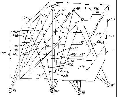
[0008] FIG. 1 shows an arrangement of seismic sensors used in a passive
seismic
emission technique.
[0009] FIG. 2 is a flowchart illustrating a method of imaging the Earth's
subsurface using
passive seismic emission sensing.
3
CA 02718917 2013-06-20
Detailed Description
[0010]
FIG. 1 shows an array of seismic sensors, individually identified as G1
through
G7, disposed at selected positions near or on the surface 12 of the Earth
above a volume
of the Earth's subsurface to be imaged using passive seismic signals. The
subsurface
volume 10 may include a plurality of different formations, examples of which
are shown
at 14, 16 and 18, each having distinct seismic properties (e.g., acoustic
impedance). A
boundary 15, 17, and 19 may represent the surface that separates two adjacent
formations
14, 16 and 18, respectively. The seismic sensors G1 through G7 may be one- or
three-
component particle motion sensors, such as geophones, accelerometers or any
similar
device known in the art to detect particle motion in the Earth. The sensors G1-
G7 can
produce an electrical or optical signal related to the magnitude of the
measured particle
motion at each sensor. It will be appreciated by those skilled in the art that
in marine
surveying wherein the volume 10 is disposed below the bottom of a body of
water, the
seismic sensors G1-G7 may be disposed in a device known as an "ocean bottom
cable"
deployed on the water bottom. The sensors Gl-G7 are operatively connected to a
3a
CA 02718917 2010-09-17
WO 2009/117336 PCT/US2009/037220
MSI-07-02PCT
recording unit 11 which includes equipment (not shown separately) for making a
time
indexed recording of the signals generated by each of the sensors Gl-G7.
[0011] During recording of the signals produced by each of the seismic
sensors G1 -G7,
various microearthquakes or other seismic events, shown at their possible
points or origin
("hypocenters") H1, H2, H3 and H4, may occur in the subsurface in or below the
volume
10. The seismic events each produce seismic energy that travels from the point
of origin
of the seismic event outwardly in all directions. Some of the seismic energy
may travel
through the volume 10 where it is eventually detected by the sensors G1 -G7.
Energy
traveling from a first one of the seismic events, e.g., H1, is shown traveling
along ray
paths HlA through H1G to respective seismic sensors G1 through G7. A similar
illustration is provided for energy from a second one of the seismic events,
shown at H2,
where seismic energy travels along ray paths indicated by H2A through H2G to
respective seismic sensors G1 through G7. For clarity of the illustration,
only a portion
of corresponding ray paths for seismic energy are shown for the other two
seismic events
H3, H4 shown in FIG. 1, but the principle is the same for these and any other
seismic
events in the subsurface. Recording of seismic signals may be performed for a
selected
period of time, for example several days or weeks. The recording unit 11 may
preferably
make digital records, indexed with respect to time, of the seismic signals
detected by each
of the seismic sensors Gl-G7.
[0012] The recorded seismic signals may be processed initially by certain
procedures
well known in the art of seismic data processing, including various forms of
filtering,
prior to interpretation according to the invention.
[0013] The spatial position hypocenter of each seismic event H1 through
H4 may be
determined from the recordings of the sensor signals using well known
techniques. One
such technique is described in, W.H.K. Lee and S.W. Stewart, Principles and
Applications of Microearth quake Networks, Advances in Geophysics, Supplement
2,
Academic Press (1981). Once the hypocenter of each seismic event is
determined, a
travel path may be determined for the seismic energy through the volume 10.
Each travel
path may begin at a calculated entry point into the volume and extend to an
exit point
4
CA 02718917 2013-06-20
corresponding to the geodetic position of each seismic sensor G1 -G7. If a
sufficient
number of different seismic energy ray paths are traversed by seismic energy
from
various seismic events in the subsurface, a model of the seismic property
(e.g., velocity)
distribution within the volume 10 may be determined using various techniques,
such as
inversion.
[0014] Another possible technique for determining the hypocenters of the
various seismic
events in the subsurface is described in U.S. Patent Application Publication
No.
2008/0068928 filed by Duncan et al., the underlying patent application for
which is
assigned to the assignee of the present invention. A method for seismic event
mapping
described in the '928 publication includes transforming seismic signals
recorded at
selected positions into a domain of possible spatial positions of a source of
seismic
events. An origin in spatial position and time of at least one seismic event
is determined
from space and time distribution of at least one attribute of the transformed
seismic data.
[0015] As is known in the art, methods for determining a model of
velocity distribution
may require a very long signal recording time to provide a sufficiently well
spatially
distributed set of seismic events, or the method may provide ambiguous
results. In a
method according to the invention, a second data processing technique may be
used in
connection with velocity inversion to constrain the model of velocity
distribution such
that a unique result may be obtained with substantially reduced signal
recording time.
[0016] One example of such second data processing technique according to
the invention
includes cross-correlating the recorded seismic signals from each seismic
sensor G1-G7
with the recorded seismic signals from each one of a plurality of the other
seismic sensors
G 1 -G7 in the sensor arrangement. In some examples, the cross correlation of
signals
from each seismic sensor may be performed with signals from every one of the
other
seismic sensors. Cross correlation in the present example may include
comparing the
entire data record (i.e. over the entire selected recording time period) from
the seismic
sensor signal in question to the entire data record from the cross-correlated
sensor signal.
The comparing begins with a time offset between compared data records of zero
and
CA 02718917 2010-09-17
WO 2009/117336 PCT/US2009/037220
MSI-07-02PCT
increments a time offset by a selected time amount (e.g., 1/4, 1A, or 1
millisecond) for each
of a plurality of subsequent comparisons. The time offset may be limited to
the expected
deepest seismic travel time for the target volume 10 (e.g., three to five
seconds). Thus,
for each cross-correlated sensor signal, an output of the cross correlation
will be a time
series beginning at zero time and ending at the selected time limit. An
amplitude value
for each time in the time series will be the degree of similarity of the cross-
correlated
sensor signal to the sensor signal in question.
[0017] In some examples, each sensor signal may be auto-correlated, that
is, the signal
record may be compared with itself at various values of time delay, just as
for the cross-
correlation.
[0018] The result of the cross-correlation, and the auto-correlation if
performed, is a set
of "traces" for each seismic sensor that correspond to seismic signals that
would be
recorded at such sensor if a seismic energy source were actuated at each one
of the cross-
correlated sensor locations.
[0019] The cross correlations made for each sensor may be processed
according to well
known techniques for controlled (active) source seismic exploration, including
for
example, normal moveout correction, and summing or stacking to produce, for
each such
sensor, a band limited reflectivity series for the Earth's subsurface
corresponding to the
geodetic position of the sensor under investigation. The reflectivity series
represents a
record with respect to seismic travel time of reflection coefficients of each
of what are
inferred as subsurface acoustic impedance boundaries in the Earth's
subsurface. In some
examples, the reflectivity series may be used to constrain an inversion
procedure used to
obtain a velocity distribution from the hypocenters determined as explained
above.
[0020] An example implementation of a method according to the invention
is shown in a
flow chart in FIG. 2. Seismic signals are recorded from each of a plurality of
deployed
seismic sensors at 20. Hypocenters of seismic events in the subsurface are
determined at
22. Signals from each of the sensors are cross-correlated to signals from a
plurality of the
other sensors at 24. The cross-correlated signals may be used, at 26, to
determine a
reflectivity series at each cross-correlated sensor. At 28, the reflectivity
series may be
6
CA 02718917 2010-09-17
WO 2009/117336 PCT/US2009/037220
MSI-07-02PCT
used to constrain a model of spatial distribution of a seismic property (e.g.,
velocity) in
the subsurface volume. At 30, the hypocenters may be used, along with the
constraints,
to generate a model of spatial distribution of the seismic property.
[0021] A three dimensional image of the Earth's subsurface may be made
using the
above spatial distribution of the seismic property. Any suitable three
dimensional ("3D")
seismic image software or tool known in the art may be used to generate the 3D
image of
the Earth's subsurface formation. Two non-limiting examples of such imaging
software
include those sold under the trademarks S2-TIME and S2-DEPTH, both of which
are
trademarks of WesternGeco LLC, Houston, Texas.
[0022] Seismic imaging techniques according to the various examples of the
invention
may provide images of the Earth's subsurface without the need to use
controlled seismic
energy sources such as vibrators or dynamite. By eliminating the need for
controlled
seismic energy sources, techniques according to the invention may present less
environmental hazard than controlled source seismic techniques, and may
provide access
to seismic exploration where surface topographic conditions make controlled
seismic
exploration techniques impracticable.
[0023] While the invention has been described with respect to a limited
number of
embodiments, those skilled in the art, having benefit of this disclosure, will
appreciate
that other embodiments can be devised which do not depart from the scope of
the
invention as disclosed herein. Accordingly, the scope of the invention should
be limited
only by the attached claims.
7