Note: Descriptions are shown in the official language in which they were submitted.
CA 02725133 2010-11-19
WO 2009/142868 1 PCT/US2009/041492
DRILLING WELLS IN COMPARTMENTALIZED RESERVOIRS
BACKGROUND OF THE DISCLOSURE
[0001] FIG. 1 illustrates an example environment for the performance of a
method of placing
a production or development well 210 into an earth formation F. In the
illustrated example, the
earth formation F comprises a first shale deposit or bed 230, a tight sand
deposit or bed 231, and
a second shale deposit or bed 232. The beds 230, 231 and 232 are located on
top of a reservoir
R. The reservoir R includes a first porous sandstone bed or reservoir
compartment 233, and an
intermediate shale bed 234 separating the first reservoir compartment 233 from
a second
sandstone bed or reservoir compartment 236. In this example, the first
compartment 233
contains a first hydrocarbon, and the second compartment 236 contains a second
hydrocarbon as
well as water. The interface between the hydrocarbon and the water is
indicated by an oil water
contact (OWC) 235. The earth formation F also comprises a fault 240 across
which the
geological structures are not continuous. Beds 230', 231', 232', 233', 234'
and 236' correspond
to similar beds 230, 231, 232, 233, 234 and 236 across the fault 240.
Similarly, an OWC 235'
corresponds to OWC 235.
[0002] In the method depicted in FIG. 1, a first pilot or exploration well 220
is initially
drilled through the formation F. As the well 220 is being drilled, logging
while drilling
measurements indicative of the physical properties of the porous rock
immediately surrounding
the well 220 are acquired. These measurements may typically include natural
gamma ray and
resistivity measurements, as well as other types of measurements known by
those skilled in the
art. Additionally, or alternatively, the drill string used to drill the well
220 may be removed from
the well 220 and a wireline-conveyed tool string may be introduced into the
well 220 to acquire
CA 02725133 2010-11-19
WO 2009/142868 2 PCT/US2009/041492
measurements indicative of the physical properties of the porous rock
immediately surrounding
the well 220. Typical operations performed by the wireline-conveyed tool
string may include
pressure measurements, formation fluid sample collections and sidewall core
collections, as well
as other types of measurements and/or collections known by those skilled in
the art. The
measurements collected while drilling and/or with a wireline tool string are
interpreted and used
to identify, for example, a location of the top of the reservoir 236, a type
and/or economical
value of the hydrocarbon contained in the beds 233 and 234, and a location of
the OWC 235,
among other things. Based on this and optionally other information, a drill
string is introduced in
the well 220 for a side-tracking well 210. The well 210 is typically a
horizontal well located at a
depth that maximizes the economical value of the expected production from the
well 210. The
well 210 may be steered geometrically along a predetermined trajectory using
periodical
measurement of the tilt of the bottom hole assembly, or geologically with
respect to the boundary
between the beds 232 and 233 using, for example, deep resistivity images of
the formation
encountered by the bottom hole assembly used to drill the well 210.
[0003] As shown in FIG. 1, as the well 210 is being drilled in bed 233, it may
cross the fault
240. In some cases, such as when the fault 240 is permeable, the type and/or
economical value
of the formation fluid present in the bed 236' is similar to the type and/or
economical value of
the hydrocarbon present in the bed 233. However, in other cases, the type
and/or economical
value of the formation fluid present in the bed 236' is unknown and can not be
inferred from
measurements collected while drilling the pilot well 220. For example, the
type and/or
economical value of the formation fluid present in the bed 236' may be
significantly lower than
in the bed 233. Thus, the depth or trajectory of the well 210, selected based
on the knowledge of
the reservoir fluid along the well 220, may not lead to a sufficient
economical value of the well
210 past the fault 240. Further, even horizontal variations of the hydrocarbon
in the bed 233
CA 02725133 2010-11-19
WO 2009/142868 3 PCT/US2009/041492
may exist. The compositional variations may require updating the trajectory
210 to increase its
economical value.
BRIEF DESCRIPTION OF THE DRAWINGS
[0004] The present disclosure is best understood from the following detailed
description
when read with the accompanying figures. It is emphasized that, in accordance
with the standard
practice in the industry, various features are not drawn to scale. In fact,
the dimensions of the
various features may be arbitrarily increased or reduced for clarity of
discussion.
[0005] Fig. 1 is a cross-sectional view of a typical formation.
[0006] Fig. 2 is a schematic view of apparatus according to one or more
aspects of the
present disclosure.
[0007] Fig. 3 is a schematic view of apparatus according to one or more
aspects of the
present disclosure.
[0008] Figs. 4A and 4B are schematic views of a log according to one or more
aspects of the
present disclosure.
DETAILED DESCRIPTION
[0009] It is to be understood that the following disclosure provides many
different
embodiments, or examples, for implementing different features of various
embodiments.
Specific examples of components and arrangements are described below to
simplify the present
disclosure. These are, of course, merely examples and are not intended to be
limiting. In
addition, the present disclosure may repeat reference numerals and/or letters
in the various
examples. This repetition is for the purpose of simplicity and clarity and
does not in itself dictate
a relationship between the various embodiments and/or configurations
discussed. Moreover, the
CA 02725133 2010-11-19
WO 2009/142868 4 PCT/US2009/041492
formation of a first feature over or on a second feature in the description
that follows may
include embodiments in which the first and second features are formed in
direct contact, and may
also include embodiments in which additional features may be formed
interposing the first and
second features, such that the first and second features may not be in direct
contact.
[0010] One or more aspects of the methods and apparatus within the scope of
the present
disclosure may be implemented to use measurements indicative of a relative
position of
geological bed boundaries with respect to a drilling assembly together with
measurements
indicative of a methane concentration in the formation fluid to control a well
trajectory. Methods
and apparatus within the scope of the present disclosure may alternatively or
additionally be
implemented to use measurements indicative of a relative position of
geological bed boundaries
with respect to a drilling assembly together with measurements indicative of a
formation fluid
optical property to control a well trajectory. One or more aspects of the
methods and apparatus
within the scope of the present disclosure may also or alternatively be used
to identify
compartmentalization as a well is being drilled and/or to steer a well based
on the identified
compartmentalization.
[0011] FIG. 2 is a schematic view of an exemplary drilling system 50 according
to one or
more aspects of the present disclosure. The drilling system 50 can be onshore
or offshore. In the
exemplary embodiment shown in FIG. 2, a borehole 11 is formed in one or more
subsurface
formations by rotary drilling in a manner that is well known. However,
implementations within
the scope of the present disclosure may also or alternatively use directional
drilling.
[0012] A drill string 12 suspended within the borehole 11 comprises a bottom
hole assembly
100 which includes a drill bit 105 at its lower end. The surface system
includes a platform and
derrick assembly 10 positioned over the borehole 11, wherein the assembly 10
comprises a
rotary table 16, a kelly 17, a hook 18, and a rotary swivel 19. The drill
string 12 is rotated by the
CA 02725133 2010-11-19
WO 2009/142868 5 PCT/US2009/041492
rotary table 16, energized by means not shown, which engages the kelly 17 at
the upper end of
the drill string 12. The drill string 12 is suspended from the hook 18
attached to a traveling block
(not shown) through the kelly 17 and the rotary swivel 19, which permits
rotation of the drill
string 12 relative to the hook 18. A top drive system could alternatively or
additionally be used.
[0013] In the illustrated example implementation, the surface system further
comprises
drilling fluid or mud 26 stored in a pit 27 located near the well site. A pump
29 delivers the
drilling fluid 26 to the interior of the drill string 12 via a port in the
swivel 19, causing the
drilling fluid to flow downward through the drill string 12 as indicated by a
directional arrow 8.
The drilling fluid exits the drill string 12 via ports in the drill bit 105,
and then circulates upward
through the annulus region between the outside of the drill string 12 and the
wall of the borehole,
as indicated by directional arrows 9. In this well known manner, the drilling
fluid 26 lubricates
the drill bit 105 and carries formation cuttings up to the surface as it is
returned to the pit 27 for
recirculation.
[0014] The bottom hole assembly 100 of the illustrated example implementation
includes a
plurality of logging-while-drilling (LWD) modules 120, 120A, a sampling-while-
drilling (SWD)
module 130, a measurement-while-drilling (MWD) module 140, a rotary-steerable
system and
motor 150 (e.g., a directional drilling subsystem), and the drill bit 105.
[0015] Use of the example methods and apparatus described herein may be in
conjunction
with controlled steering or "directional drilling" using the rotary-steerable
subsystem 150.
Directional drilling is the intentional deviation of the wellbore from the
path it would naturally
take. In other words, directional drilling is the steering of the drill string
so that it travels in a
desired direction. Directional drilling comprises geometrical steering, in
which the drill bit is
typically steered along a pre-determined path in an Earth formation, and
geological steering, in
which the drill bit is typically steered relative to geological features of
the Earth formation.
CA 02725133 2010-11-19
WO 2009/142868 6 PCT/US2009/041492
Directional drilling may be advantageous in offshore drilling because, for
example, it may enable
many wells to be drilled from a single platform. Directional drilling may also
enable horizontal
drilling through a reservoir. Horizontal drilling may enable a longer length
of the wellbore to
traverse the reservoir, which may increase the production rate from the well.
A directional
drilling system may also be used in vertical drilling operations. Often the
drill bit 105 will veer
off of a planned drilling trajectory because of the unpredictable nature of
the formations being
penetrated or the varying forces that the drill bit 105 experiences. When such
a deviation occurs,
a directional drilling system (e.g., the rotary-steerable subsystem 150) may
be used to put the
drill bit 105 back on course.
[0016] A known method of directional drilling includes the use of a rotary
steerable system
("RSS"). In an RSS, the drill string 12 is rotated from the surface, and
downhole devices cause
the drill bit 105 to drill in the desired direction. Rotating the drill string
12 greatly reduces the
occurrences of the drill string 12 getting hung up or stuck during drilling.
Rotary steerable
drilling systems for drilling deviated boreholes into the earth may be
generally classified as
either "point-the-bit" systems or "push-the-bit" systems. In point-the-bit
systems, the axis of
rotation of the drill bit 105 is deviated from the local axis of the bottom
hole assembly 100 in the
general direction of the new hole. The hole is propagated in accordance with
the customary
three point geometry defined by upper and lower stabilizer touch points and
the drill bit 105.
The angle of deviation of the drill bit 105 axis coupled with a finite
distance between the drill bit
105 and a lower stabilizer results in the non-collinear condition required for
a curve to be
generated. There are many ways in which this may be achieved, including a
fixed bend at a
point in the bottom hole assembly 100 close to the lower stabilizer, or a
flexure of the drill bit
105 drive shaft distributed between an upper and the lower stabilizer. In its
idealized form, the
drill bit 105 is not required to cut sideways because the bit axis is
continually rotated in the
CA 02725133 2010-11-19
WO 2009/142868 7 PCT/US2009/041492
direction of the curved hole. Examples of point-the-bit type rotary steerable
systems and their
operation are described in U.S. Patent Application Publication No.
2001/0052428 and U.S.
Patent Nos. 6,401,842; 6,394,193; 6,364,034; 6,244,361; 6,158,529; 6,092,610;
and 5,113,953,
all of which are hereby incorporated herein by reference in their entireties.
[0017] In push-the-bit rotary steerable systems, there is usually no specially
identified
mechanism to deviate the bit axis from the local bottom hole assembly axis.
Instead, the
requisite non-collinear condition is achieved by causing either or both of
upper and lower
stabilizers to apply an eccentric force or displacement in a direction that is
preferentially
orientated with respect to the direction of hole propagation. There are many
ways in which this
may be achieved, including non-rotating (with respect to the hole) eccentric
stabilizers
(displacement based approaches) and eccentric actuators that apply force to
the drill bit in the
desired steering direction. Steering is achieved by creating non co-linearity
between the drill bit
105 and at least two other touch points. In some instances, the drill bit 105
is required to cut
sideways to generate a curved hole. Examples of push-the-bit type rotary
steerable systems and
their operation are described in U.S. Patent Nos. 5,265,682; 5,553,678;
5,803,185; 6,089,332;
5,695,015; 5,685,379; 5,706,905; 5,553,679; 5,673,763; 5,520,255; 5,603,385;
5,582,259;
5,778,992; and 5,971,085, all of which are hereby incorporated herein by
reference in their
entireties.
[0018] The MWD module 140 is housed in a special type of drill collar, as is
known in the
art, and can comprise one or more devices for measuring characteristics of the
drill string 12 and
drill bit 105. The MWD module 140 further comprises an apparatus (not shown)
configured to
generate electrical power delivered to the downhole system. This may include a
mud turbine
generator powered by the flow of the drilling fluid. However, other power
and/or battery
systems may also or alternatively be employed. The MWD module 140 may comprise
one or
CA 02725133 2010-11-19
WO 2009/142868 8 PCT/US2009/041492
more of measuring devices configured to measure weight-on-bit, torque,
vibration, shock, stick-
slip, direction, and/or inclination. The MWD module 140 may also comprise
capabilities for
communicating with surface equipment.
[0019] The LWD modules 120, 120A are housed in a special type of drill collar,
as is known
in the art, and can comprise one or a plurality of known types of logging
tools. The LWD
modules 120, 120A may be configured to measure, process and/or store
information, and to
communicate with the MWD module 140. The LWD modules 120, 120A may be used to
implement a resistivity array having a modular design. For example, each LWD
module 120,
120A may be used to implement a resistivity module with at least one antenna
that can function
as a transmitter or a receiver, wherein the LWD modules 120, 120A are spaced
apart on a drill
string and separated by at least one downhole tool (e.g., the SWD module 130).
Each LWD
module 120, 120A may comprise at least one antenna coil with a magnetic moment
orientation
not limited to the tool longitudinal direction. A spacing between the
transmitter and receiver
modules may be selected based on expected reservoir thickness. Embodiments
within the scope
of the present disclosure may also comprise more than two LWD tools, including
more that two
LWD tools each having an antenna.
[0020] The LWD modules 120, 120A may be used to implement a geosteering method
while
drilling the formation by generating a plurality of formation models for the
formation, where
each of the plurality of the formation models includes a set of parameters and
a resistivity tool
therein and locations of the resistivity tool differ in the plurality of the
formation models. Such
method may also include computing predicted tool responses for the resistivity
tool in the
plurality of formation models, acquiring resistivity measurements using the
resistivity tool in the
formation with the resistivity modules 120, 120A, and determining an optimum
formation model
based on a comparison between the actual tool response and the predicted tool
responses. The
CA 02725133 2010-11-19
WO 2009/142868 9 PCT/US2009/041492
method may further include steering a bottom hole assembly based on the
optimum formation
model.
[0021] The resistivity measurements collected by the resistivity modules 120,
120A may be
inverted using a Bayesian method. For example, as a well is being drilled
(e.g., the well 310
depicted in FIGS. 4A and 4B), the measurements acquired by the LWD modules
120, 120A may
be utilized to compute a plurality of probability curves (see, e.g.,
probability curve 350 in FIG.
4A, represented in superposition to the geological structure of the formation
F). The probability
curves may express the magnitude of the probability of a geological bed
boundary as a function
of a relative position with respect to the drilling assembly 100. Thus, the
local maxima of any
probability curve may be indicative of a relative position of a geological bed
boundary with
respect to the drilling assembly 100 and/or the drilled well (e.g., the well
310). In addition, the
resistivity modules 120, 120A may be configured to be capable of detecting a
fault (e.g., the fault
240).
[0022] Further, the resistivity measurements collected by the resistivity
modules 120, 120A
may be configured to determine one or more components of the resistivity
tensor of the beds
delimited by the bed boundaries. Thus, the measurements acquired by the
resistivity modules
120, 120A may be used to identify resistivity contrast in a bed, such as
observable at an oil-water
contact (e.g., oil-water contacts 235, 235').
[0023] Examples of resistivity imaging tools and methods of use may be found
in U.S. Patent
Publication No. 2006/0011385 and U.S. Patent 7,093,672, each hereby
incorporated herein by
reference in their entireties.
[0024] The SWD module 130 may comprise a probe 131 configured to be
selectively
extended into sealing contact with the wall of the wellbore 11. In the
extended position, the
probe 131 is configured to establish fluid communication between a flow line
in the SWD
CA 02725133 2010-11-19
WO 2009/142868 10 PCT/US2009/041492
module 130 and the formation, A pump (not shown) disposed in the SWD module
130 may be
energized for extracting fluids from the formation into the flow line. After
mud filtrate has been
extracted from the formation immediately surrounding the wellbore 11, pristine
formation fluid
is drawn into SWD module 130. A plurality of sensors may be disposed on the
flowline in the
SWD module 130 and configured to aid in determining a value indicative of a
methane
concentration in the formation fluid, a value indicative of a formation fluid
optical property,
and/or a property of a hydrocarbon in the compartment, among other values
and/or
characteristics.
[0025] A schematic view of an exemplary flow line 500 disposed in the SWD
module 130 is
shown in FIG. 3. The flow line 500 is equipped with a first light source 510
configured to emit
light in the visible and/or NIR range. The light is directed toward the fluid
extracted from the
formation and circulating in the flow line 500 through an optical window 520.
The light
emerging from the fluid through a second optical window 530 is directed
towards one or more
optical spectrometers (e.g., a filter spectrometer 540 and a grating
spectrometer 550).
[0026] The optical density (OD) of the fluid may be determined at one or more
preselected
wavelengths. One example of measurement collected by the filter spectrometer
540 is illustrated
by the spectrum log 330 of FIG. 4A. The spectrum 330 includes a visual
representation of the
measured optical densities 331a, 331b, 331j corresponding to preselected
wavelengths in the
visible and NIR range, and preselected wavelength widths. The spectrum log 330
comprises a
plurality of bars, the thickness of which represents the amplitude of the
measured OD for each of
the wavelengths on, for example, a scale between 0 and 5. In the example shown
in FIG. 4A, the
analyzed fluid has a large measured OD 331a, 331b, and a low measured density
331j. In
addition, these optical densities, and optionally the OD measured by the
grating spectrometer
550, may be used to determine a partial composition 320. In the shown example,
the
CA 02725133 2010-11-19
WO 2009/142868 11 PCT/US2009/041492
composition 320 comprises a weight percentage of methane 321, a weight
percentage of the
lumped group comprising ethane, propane, and butanes, and a weight percentage
of the lumped
group comprising hexane and hydrocarbon molecules having more than 6 carbon
atoms in the
molecule. Other compositions (not shown) may also include the weight percent
of carbon
dioxide and/or water, among others.
[0027] Still referring to FIG. 3, the flow line 500 may also be equipped with
a second light
source 560 configured to emit an essentially monochromatic light beam in the
UV range. The
light is directed toward the sampled fluid at one or more incident angles. The
reflected light may
be also measured at one or more reflected angles to, for example, determine
the presence of gas
and/or emulsion in the fluid flowing through the flow line 500. Fluorescent
light may also be
measured at wavelengths different from the emitted light. The flow line 500
may also be
equipped with a pressure and temperature gauge (e.g., a quartz gauge) 570, a
resistivity cell 580,
and a density and viscosity sensor 590. The density and viscosity sensor 590
may be configured
to analyze the resonance frequency of a rod vibrating in the flow line 500.
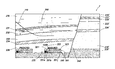
[0028] FIGS. 4A and 4B depict aspects of obtaining a new well trajectory 310
in the
formation F of FIG. 1 using the drilling system 50 of FIG. 2. FIGS. 4A and 4B
represent the
formation F of FIG. 1, using like or identical reference numbers to identify
common or similar
geological structures present in FIG. 1. As shown, the well 310 is drilled
from left to right.
[0029] In contrast to the method depicted in FIG. 1, a pilot well 220 is not
required to
determine the top of the reservoir (e.g., the boundary between beds 232 and
233). Indeed, by
utilizing the measurements provided by the resistivity modules 120, 120A, the
top of the
reservoir may be identified even if the BHA 100 is located, for example, 70
feet away from the
top of the reservoir. The curves 350 may be used to determine the distance
between the BHA
100 and geological boundaries. The inverted components of the resistivity
sensor corresponding
CA 02725133 2010-11-19
WO 2009/142868 12 PCT/US2009/041492
to the beds 230, 231, 232 and 233 may be used to distinguish between shales,
tight sandstones
and oil bearing porous sandstones. Thus, as the top of the reservoir is
identified, the trajectory of
the well 310 may be altered to land the well horizontally in the bed 233.
[0030] Also in contrast to the method illustrated in FIG. 1, a pilot well 220
is not required to
determine the OWC 235 and/or the intermediate shale 234. Indeed, by utilizing
the
measurements provided by the resistivity modules 120, 120A, the OWC 235 may be
identified
even if the BHA 100 is located, for example, 100 feet away from the top of the
reservoir.
[0031] Once the well 310 has been landed in the bed 233, a sampling operation
may be
initiated. The relative location of the bottom hole assembly with respect to
the geological
boundaries may be used to initiate fluid sampling and analysis operations
based on the detection
that a geological boundary has been crossed. Fluid extraction operations may
require the drilling
operation to be momentarily stopped so that a sampling probe 131 may establish
an exclusive
fluid communication with the formation F. Fluid extraction may then be
initiated by the SWD
module 130, and may last approximately 30 minutes or more in order to extract
mud filtrate from
the formation and subsequently obtain pristine reservoir fluid in the sampling
tool. During this
time, the BHA 100 is not rotated, increasing thereby the risk that the BHA may
stick to the
formation. It may be therefore beneficial in some cases to limit the number of
locations at which
the SWD module 130 is used. For example, these locations may be selected based
on the
relative location of the bottom hole assembly with respect to the geological
boundaries, such as
once a geological boundary has been crossed, among other considerations.
[0032] The drilling system 55 of FIG. 2 may allow more complete
characterization of the
reservoir compartment 233. For example, a hydrocarbon reservoir compartment
may be
identified by determining (1) the relative locations of the geological
boundary of the
compartment with respect to the well, and (2) at least one property of a
hydrocarbon in the
CA 02725133 2010-11-19
WO 2009/142868 13 PCT/US2009/041492
compartment. By analyzing the formation fluid extracted from the compartment
233 using one
or more of the sensors shown in FIG. 3, a spectral signature (e.g., optical
signature and/or NMR
signature) of the fluid may be used to distinguish between a dry gas bearing
compartment, a wet
gas bearing compartment, a gas condensate retrograde bearing compartment, a
volatile oil
bearing compartment, a non volatile oil bearing compartment, and a heavy oil
bearing
compartment. For example, the spectral signature measured may be provided to a
surface
operator in the form of an optical density in the visible range (oil color), a
partial composition
(e.g., the partial composition 320), and/or a GOR. Thus, as the well 310 is
landed in the
compartment 233, the drilling system 55 may be used to compare fluid
properties expected from,
for example, prior knowledge of the formation F (e.g., via offset wells). If
the measured
property does not match the expected property, the trajectory of the well 310
may be altered to,
for example, intersect the compartment 136. Additional measurements may be
performed in a
same compartment to, for example, detect horizontal composition gradients in
the compartment.
The drilling system 55 may in turn be used to adjust the drilling direction of
the well 310 in
response to a detected horizontal composition gradient to, for example,
increase or decrease the
distance separating the well 310 and the top of the reservoir.
[0033] As shown in FIG. 4B, the well 310 may eventually cross the fault 240.
The fault 240
may be detected from measurements acquired with the resistivity modules 120,
120A. However,
in some cases, the resistivity modules 120, 120A may measure components of the
resistivity
tensor in the compartment 234' having similar values as the measured
components of the
resistivity tensor in the compartment 233. Once a new compartment is being
drilled, the SWD
module 130 may be used to investigate the compartment using downhole fluid
analysis (DFA).
In the shown example, the fluid in the compartment 234' may have the expected
partial
composition 420 and the optical spectrum 430, both based on measurements
performed in the
CA 02725133 2010-11-19
WO 2009/142868 14 PCT/US2009/041492
compartment 233. However, the measured properties may indicate a different oil
as illustrated
by measured partial composition 520 and optical spectrum 530. Based on this
information, as
well as the detected geological boundaries, the well 310 may then be steered
away from the oil-
water contact and towards the compartment 233'. Once the well is landed in the
compartment
233', a new downhole fluid analysis operation may be performed.
[0034] In view of all of the above and the Figures, those skilled in the
pertinent art should
readily recognize that the present disclosure introduces a method of drilling
a well, comprising
determining a first value indicative of a relative position of a geological
bed boundary with
respect to a drilling assembly, determining a second value indicative of a
methane concentration
of a formation fluid proximate the drilling assembly, and controlling a well
trajectory based on
the first and second values. The first value may be obtained with an electro-
magnetic
propagation while drilling tool, an electrical induction while drilling tool,
and/or an acoustic
while drilling tool. The second value may be obtained with a sampling while
drilling tool, a near
infrared (NIR) spectrometer, a nuclear magnetic resonance (NMR) spectrometer,
and/or at least
one of a mass spectrometer and a gas chromatographer. The second value may
comprise a gas-
oil ratio (GOR).
[0035] Another method introduced in the present disclosure comprises
determining a first
value indicative of a relative position of a geological bed boundary with
respect to a drilling
assembly, determining a second value indicative of an optical property of a
formation fluid
proximate the drilling assembly, and controlling a well trajectory based on
the first and second
value. The optical property of the formation fluid may be an absorption at one
or more
wavelengths, wherein the one or more wavelengths may be at least partially in
at least one of the
visible range and the near infrared (NIR) range. The optical property of the
formation fluid may
be a fluorescence intensity at one or more wavelengths, wherein the one or
more wavelengths
CA 02725133 2010-11-19
WO 2009/142868 15 PCT/US2009/041492
may be at least partially in the UV range. The optical property of the
formation fluid may be a
reflection intensity at one or more incidence angles at an interface between
the formation fluid
and a light transmitting window.
[0036] The present disclosure also introduces a method of drilling a well
comprising
identifying a hydrocarbon reservoir compartmentalization by determining at
least one relative
location of a geological boundary of the compartment with respect to the well
and at least one
property of a hydrocarbon in the compartment. Such method further comprises
adjusting a well
trajectory based on the determined compartmentalization.
[0037] The present disclosure also introduces a method of evaluating a
formation penetrated
by a well, comprising lowering a drilling apparatus in the formation, wherein
the drilling
apparatus comprises a drilling assembly, an imaging tool, and a fluid sampling
tool. The
imaging tool is used to determine at least one relative location of a
geological boundary of a
compartment with respect to the well. The drilling assembly is used to extend
the well beyond
the determined geological boundary. The fluid sampling tool is used to extract
fluid from the
formation located beyond the determined geological boundary. The method
further comprises
measuring a property of the extracted fluid using at least one of a density
sensor, a viscosity
sensor, and an optical sensor.
[0038] The present disclosure also introduces an apparatus comprising an
imaging tool
configured to determine at least one relative location of a geological
boundary of a compartment
with respect to a well penetrating a subterranean formation, a drilling
assembly configured to
extend the well beyond the determined geological boundary, a fluid sampling
tool configured to
extract fluid from the formation located beyond the determined geological
boundary, and a
sensor configured to measure a property of the extracted fluid.
CA 02725133 2010-11-19
WO 2009/142868 16 PCT/US2009/041492
[0039] The present disclosure also introduces an apparatus comprising means
for
determining a first value indicative of a relative position of a geological
bed boundary with
respect to a drilling assembly. Such apparatus also comprises means for
determining a second
value indicative of an optical property of a formation fluid proximate the
drilling assembly,
wherein the optical property is selected from the group consisting of: an
absorption at one or
more wavelengths; a fluorescence intensity at one or more wavelengths; and a
reflection
intensity at one or more incidence angles at an interface between the
formation fluid and a light
transmitting window. The apparatus further comprises means for controlling a
well trajectory
based on the first and second value. The optical property of the formation
fluid may be selected
from the group consisting of: an absorption at one or more wavelengths at
least partially in at
least one of the visible range and the near infrared (NIR) range; and a
fluorescence intensity at
one or more wavelengths at least partially in the UV range.
[0040] The foregoing outlines features of several embodiments so that those
skilled in the art
may better understand the aspects of the present disclosure. Those skilled in
the art should
appreciate that they may readily use the present disclosure as a basis for
designing or modifying
other processes and structures for carrying out the same purposes and/or
achieving the same
advantages of the embodiments introduced herein. Those skilled in the art
should also realize
that such equivalent constructions do not depart from the spirit and scope of
the present
disclosure, and that they may make various changes, substitutions and
alterations herein without
departing from the spirit and scope of the present disclosure.