Note: Descriptions are shown in the official language in which they were submitted.
CA 02725351 2010-12-15
GAS FLUX DETERMINATION USING AIRBORNE DIAL LIDAR AND AIRBORNE WIND
MEASUREMENT
FIELD OF INVENTION
The present invention relates, in general, to the field of spectroscopic
analysis
of a gas plume. More specifically, the present invention relates to
determining the
emission rate, or flux of a gas plume emanating from a source, by using an
aircraft
that houses both a differential absorption LIDAR (DIAL) system and a wind
measurement system. The present invention improves on the accuracy of the
emission rate by scaling the airborne wind measurement from the aircraft's
flying
altitude to the gas plume's near ground altitude.
BACKGROUND OF THE INVENTION
Technologies available for the rate quantification of gas(es) emitted from a
point source such as a smokestack or a leaking pipeline are numerous and well
22061638.2
CA 02725351 2010-12-15
-2-
understood. These techniques include use of rotameters or hot-wire anemometers
to
measure the velocity of gases escaping from a hole of known size. Also
included are
more high tech devices like a Hi-Flow sampler which is an instrument that
combines a
hydrocarbon detector with a flow meter and vacuum system.
Measurement of emission flux from larger, more complex non-point sources of
emissions may be accomplished by numerical calculations within the facility
(for
example, calculations based on amount of material lost), by direct point-
sampling of
the gas plume downwind of the source, or (most recently) by use of path
integrated
optical remote sensing. Non-point-source emissions of gases like methane and
other
volatile organic carbons (VOCs) are numerous and variable and include
refineries,
industrial complexes, sewage systems, tank farms, landfills, agricultural
sites, coal
mines, oil and gas exploration and production sites and pipeline networks.
Measuring
the emissions from these types of sites is made more difficult by the fact
that exact
sources of emission are not always known.
There are several optical technologies available to quantify the gases emitted
from non-point sources. These optical technologies include Open-Path Fourier
Transform InfraRed Spectroscopy (OP-FTIR), Ultra-Violet Differential Optical
Absorption Spectroscopy (UV-DOAS), Tunable Diode Laser Spectroscopy (TDLAS),
and
Path Integrated Differential Absorption Lidar (PI-DIAL). These optical remote
sensing
technologies are all ground based, active optical instruments which pass light
through
a plume of gas and measure a path-integrated concentration of gas in the plume
by
detecting changes in light passing through the gas plume. Further, these
technologies
rely on one or more retro-reflectors or separate light sources and detectors
on either
side of the gas plume.
Measurement approaches include horizontal plume mapping, vertical plume
mapping and one-dimensional mapping downwind of a plume. Another measurement
technique is Solar Occultation Flux (SOF) which uses IR and the sun as an
optical
source from a fixed or moving ground-based platform.
Many of the conventional techniques for measurement of gaseous emission are
ground-based and require long term (several days) access to sites and
unobstructed
optical paths down-wind of the emission source(s). Remote or hard to access
sites are
difficult and expensive to measure. In addition, measurements are time
consuming
22061638.2
CA 02725351 2010-12-15
-3-
and take days or weeks to complete as an operator waits for the right wind
conditions
to direct a plume to a designated optical measurement path.
Because shifts in wind speed and direction result in an ever-changing plume of
gas from a site, combining instrument readings from different optical paths
over a
period of time results in inaccurate flux calculations. Instruments like the
SOF, which
rely on the sun as an illumination source, require low cloud cover and high
sun angle
to produce sufficient light for usable measurements. In addition, using the
SOF
requires access to the site and a drivable road some distance downwind of the
gas
source.
These techniques only allow a partial optical view of ground-hugging plumes,
since the instruments are mounted on the tops or sides of vehicles and cannot
make
measurements fully extending to ground level. Further, these techniques only
allow a
near instantaneous (a few seconds at most) snapshot of an entire plume cross
section
by using a single non-average wind speed and direction when calculating flux.
Accurate wind measurement is a major source of error for these techniques
because the wind is constantly shifting. As a result, pre-positioning retro-
reflectors
and optical detectors to provide usable flux calculation is largely guesswork
and
frequently requires subsequent deployment of more ground equipment. These
techniques also require access of a truck or vehicle to the site, which
typically has to
be shipped in from overseas. Because of their complexity and time consumption,
the
cost of using these technologies is high. Only a handful of sites may be
measured a
year.
Optical remote sensing techniques, on the other hand, are more efficient and
require less time to detect gas plumes, by using instrumentation mounted in a
fixed
wing aircraft that flies hundreds of feet above the gas plume. An example of
such
instrumentation is the DIAL (differential absorption LIDAR) system, also
referred to
herein as the ANGEL system. The ANGEL system is described in U.S. Patent No.
6,822,742.
Briefly, the ANGEL system includes a sensor for remote quantitative detection
of fluid leaks from a natural gas or oil pipeline by use of an airborne
platform. The
system includes a laser light source for illuminating an area of target gases
and
22061638.2
CA 02725351 2010-12-15
-4-
background. The target gases may be characterized by one or more absorption
wavelengths (also referred to as on-line). The background may be characterized
by a
non-absorbable wavelength (also referred to as off-line) that is different
from the
target gases.
For example, the ANGEL system may use a 3-line tunable DIAL laser system for
measuring the concentration path-lengths (CPL) of two selected target gases.
When
the airborne platform reaches a target location, laser beams are automatically
pointed
to the target location for scanning the surrounding regions. The returned
laser beams
are analyzed to develop two-dimensional gas-maps or images of gases, such as
methane and ethane, in units of CPL.
In a 2-line tunable DIAL laser system, for example, two single wavelength,
laser pulses are transmitted. One laser pulse of a specific wavelength is
chosen which
is absorbed by the gas of interest, and the other laser pulse, chosen at a
different
wavelength, is not absorbed. The energy reflected back to the sensor for both
wavelengths is measured to generate an estimate of the target CPL. The energy
reflected back to the sensor is described by the following relationship:
ETP. exp[-2(CLP +CbgR)a(X)]
Ea
R 2
where ET is the transmitted energy,
p,, is the surface reflectance,
CLp (same as CPL) is the concentration-length product of the gas,
Cbg is the background concentration of the gas,
R is the range to the surface, and
22061638.2
CA 02725351 2010-12-15
-5-
6(X) is the absorption cross-section of the gas as a function of
wavelength.
The target CPL is calculated in units of ppm-m (parts per million X meter).
As will be described, the present invention relates to determining the
emission rate, or flux of a gas plume emanating from a source, by using an
aircraft
that houses both the differential absorption LIDAR (DIAL) system, or the ANGEL
system, and an airborne wind measurement system. The present invention
improves
on the accuracy of the emission rate by scaling the airborne wind measurement
from
the aircraft's flying altitude to the gas plume's near ground altitude.
SUMMARY OF THE INVENTION
To meet this and other needs, and in view of its purposes, the present
invention provides a system for determining emission rate of a gas from a
source. The
system includes an optical remote sensing system, disposed in an aircraft, for
emitting
an optical beam downwardly, along a length dimension of a flight path, and
measuring
differential absorption characteristics of the gas plume emitted at near
ground level.
Also included is a wind measuring system, disposed in the aircraft, for
determining
wind speed and wind heading at an altitude level of the aircraft. A processor
determines emission rate of the gas plume, in response to (a) the differential
absorption characteristics of the gas plume measured by the optical remote
sensing
system, and (b) the wind speed and wind heading determined by the wind
measuring
system.
The differential absorption characteristics include multiple concentration
path
length (CPL) values along a length dimension of the gas plume, and the length
dimension of the gas plume is the same as the length dimension of the flight
path.
The CPL values are determined over an area defined by the length dimension of
the
gas plume and a width dimension, perpendicular to and smaller than the length
dimension. The width dimension is at least a width dimension of the optical
beam.
The width dimension may also be a width dimension extended by the optical beam
in
a conical scan mode.
22061638.2
CA 02725351 2010-12-15
-6-
The differential absorption characteristics include multiple concentration
path
length (CPL) values along a length dimension of the flight path. The processor
uses
the multiple CPL values to determine either (a) an area-integrated
concentration (AIC)
value or (b) an average concentration value over a cross-plume extent, defined
along
the length dimension of the flight path. The processor receives the wind speed
and
wind heading from the wind measuring system and scales the wind speed from the
aircraft altitude level to the near ground level of the gas plume.
The processor scales the wind speed based on imagery of the gas plume, and
the aircraft altitude level. The processor also scales the wind speed based on
a
logarithmic function of a wind profile including a roughness length, and the
roughness
length is obtained from a look up table (LUT) stored in a memory device. The
processor may adjust the wind heading received from the wind measuring system
after a comparison to a wind heading received from a plume heading detector
disposed in the aircraft. The processor then uses the adjusted wind heading in
determining the emission rate of the gas plume.
The scaled wind speed and wind heading comprises a wind vector. The
processor multiplies either (a) the determined area-integrated concentration
(AIC)
value or (b) the average concentration value with a component of the wind
vector, in
which the component is defined, by a vector perpendicular to the length
dimension of
the flight path.
Another embodiment of the present invention includes an airborne system for
obtaining an emission flux measurement of a gas plume, emanating from a source
at a
near ground altitude level, comprising: (a) an airborne differential
absorption lidar
(DIAL) system for determining multiple concentration path length (CPL) values
along a
flight path; (b) an airborne wind measuring system (WMS) for determining a
wind
vector at aircraft altitude; and (c) a processor for receiving the multiple
CPL values
determined by the DIAL system and the wind vector determined by the WMS. The
processor uses the CPL values to compute either (a) an area-integrated
concentration
(AIC) value or (b) an average concentration value over a cross-plume extent,
defined
along the length dimension of the flight path. The processor scales the wind
vector to
the near ground altitude level of the gas plume to obtain a scaled wind
vector. The
processor also obtains the emission flux by multiplying either the AIC value
or the
average concentration value with a component of the scaled wind vector. The
22061638.2
CA 02725351 2010-12-15
-7-
component of the scaled wind vector is defined by a vector perpendicular to
the length
dimension of the flight path.
The cross plume extent includes a predetermined length spanning at least a
portion of the gas plume. A width dimension is included perpendicular to and
smaller
than the cross plume extent having at least a width of an optical beam
transmitted by
the DIAL system. The processor computes the AIC value or the average
concentration
value using the CPL values in an area formed by the cross plume extent and the
width
dimension. The processor receives the CPL values along the cross plume extent
substantially concurrently with the wind vector.
Yet another embodiment of the present invention is a method of obtaining
emission flux of a gas plume from an emission source. The method includes the
steps
of:
(a) obtaining CPL values along an area determined by a cross plume extent and
a width dimension, wherein the cross plume extent is along a length dimension
of a
flight path and the width dimension is perpendicular to the length dimension;
(b) receiving a wind vector from an onboard aircraft wind measuring system;
(c) computing either (a) an area-integrated concentration (AIC) value or (b)
an
average concentration value, using the CPL values along the area;
(d) scaling the wind vector to a near ground altitude level of the gas plume
to
obtain a scaled wind vector, and
(e) multiplying either the AIC value or the average concentration value with a
component of the scaled wind vector to obtain the emission flux of the gas.
Multiplying with the component includes multiplying with a component of the
scaled wind vector which is perpendicular to the cross plume extent.
Obtaining the CPL values along the cross plume extent is performed
substantially concurrently with receiving the wind vector from the onboard
aircraft
wind measuring system.
Scaling the wind vector is based on a logarithmic function of a wind profile
including a roughness length, and the roughness length is obtained from a look
up
table (LUT) stored in a memory device.
It is understood that the foregoing general description and the following
detailed description are exemplary, but are not restrictive of the invention.
22061638.2
CA 02725351 2010-12-15
-8-
BRIEF DESCRIPTION OF THE FIGURES
The invention may be understood from the following detailed description when
read in connection the accompanying figures.
FIG. 1 is an exemplary illustration showing a laser conical scan illumination
of a
target area.
FIG. 2 is an exemplary illustration showing a laser straight line scan
illumination of a target area.
FIG. 3 is a block diagram of a system for determining emission rate of a gas,
according to an exemplary embodiment of the present invention.
FIG. 4A is an exemplary top view of an area formed by a flight path of a laser
conical scan illumination with respect to a gas plume.
FIG. 4B is an exploded view of a portion of the area formed by the flight path
shown in Fig. 4A.
FIG. 5 is a flowchart illustrating a method for determining emission rate of a
gas plume, according to an exemplary embodiment of the present invention.
FIG. 6A is a plot of altitude versus temperature for the convective boundary
layer (CBL) of the atmosphere formed during the day.
FIG. 6B is a plot of altitude versus temperature for the stable boundary layer
(SBL) of the atmosphere formed during the night.
FIG. 7A is a plot of altitude versus horizontal wind speed for the convective
boundary layer (CBL) of the atmosphere formed during the day.
FIG. 7B is a plot of altitude versus horizontal wind speed for the stable
boundary layer (SBL) of the atmosphere formed during the night.
22061638.2
CA 02725351 2010-12-15
-9-
DETAILED DESCRIPTION OF THE INVENTION
Referring first to FIG. 1, laser light 102 transmitted from the ANGEL system
illuminates target area 104 using a conical scan (scanner-on mode).
Alternatively,
laser light 202 transmitted from the ANGEL system may illuminate target area
204 in
a straight line (scanner-off mode), as shown in FIG. 2. Both modes may be used
by
the present invention.
With the exception of deploying lightweight wind sensor instrumentation, the
ANGEL system does not need to enter a site to make measurements. The system
may
fly at high speeds (i.e. 120 mph) and measure large plumes in seconds, in
effect
providing a snapshot of the plume in time. As a result, measurements taken by
the
ANGEL system are more accurate than other systems which attempt to quantify a
moving plume in several pieces.
For example, at a flight speed of 120 mph and a transmission rate of 1,000
pulses/second, the pulses are spaced about 2 inches apart providing a
"curtain" of gas
measurements to fully capture a cross section of the plume. Because the laser
light
from the ANGEL system reflects off the ground surface, the entire height of
the plume
is measured all the way down to the ground, thereby resulting in a more
accurate
measurement. Because measurements are collected so rapidly, the wind direction
may be factored into the data collection and the pilot may fly downwind of the
site and
have a higher likelihood of acquiring a cross section of the plume
perpendicular to the
wind direction. Further, because the ANGEL system collects data rapidly while
airborne, multiple sites may be measured in a single day, much more
efficiently than
ground-based technologies.
According to an exemplary embodiment of the invention, the emission rate or
flux may be determined from a gas source, such as methane, by flying down-wind
and
across the plume while measuring gas concentration (CPL or concentration X
path
length) from the airplane to the ground using an airborne measurement system,
such
as the ANGEL system, that has sufficient spatial density to map the cross-
plume path
concentration profile. The exemplary embodiments, however, are not limited to
the
measurements of methane. Any other gas, or multiple gases may be measured in a
similar manner.
22061638.2
CA 02725351 2010-12-15
-10-
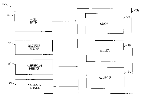
Referring next to FIG. 3, the present invention is exemplified in system 300
for
determining the emission rate or flux of a gas source. The system 300 includes
ANGEL
system 302 and processor 304. The processor 304 may be hard wired to ANGEL
system 302 or wirelessly linked to ANGEL system 302. Further, processor 304
may be
disposed in close proximity to ANGEL system 302 or remotely from ANGEL system
302.
The system 300 also includes wind speed detector 306 and wind heading
detector 308 for measuring wind speed and wind heading (direction) with
respect to
the gas plume. The wind speed and wind heading may be measured by local
weather
stations in the area. That is, the wind speed and wind heading may be measured
remotely from the gas plume. Alternatively, wind measurements may be measured
in
close proximity to the gas plume. A plume heading detector may also be
included, as
shown by detector 311.
As shown in FIG. 3, processor 304 includes memory 310 for storing data
provided from ANGEL system 302, wind speed detector 306 and wind heading
detector
308. The processor 304 also includes a selector 314 for designating an in-
plume area
extending across a plume of gas having a length dimension greater than a width
dimension. The processor 304 further includes a calculator 312 for calculating
the
emission rate or flux of the gas plume from the data stored in memory 310.
FIG. 4A is a top view of a path of a conically scanned laser light transmitted
from the ANGEL system. As shown, conical scan path 400 traverses in-plume area
402 having a length dimension L greater than a width dimension W. Conical scan
path
400 also traverses first area 404 adjacent to in-plume area 402 and second
area 406
adjacent to in-plume area 402. The direction of cross plume extent 408 (the
heading
in which the cross-plume distance is measured) within in-plume area 402 is
shown.
The plume or wind vector 410, which may be resolved into cross-plume extent
408
and a perpendicular component 412, is also shown.
In operation, as conical scan path 400 traverses in-plume area 402 and
adjacent background areas 404 and 406, ANGEL system 302 determines a plurality
of
CPL measurements for in-plume area 402 and both adjacent background areas 404
and 406. The CPL measurements include vertical CPL measurements in vertical
paths
from the airborne platform to the in-plume area 402 and adjacent background
areas
22061638.2
CA 02725351 2010-12-15
-11-
404 and 406. The plurality of CPL measurements are provided to processor 304
and
stored in memory 310 as CPL values.
Selector 314, which may be operator controlled, designates in-plume area 402
extending across a plume of gas. An area-integrated CPL concentration (AIC)
value
for in-plume area 402 may then be determined by calculator 312. The AIC value
for
in-plume area 402 is derived from the multiple CPL values found in in-plume
area 402.
The CPL values are integrated across the in-plume area by calculator 312 to
produce
the AIC value (Jcross-plume (CPLverticai) dL) covering the entire length L and
height of
the plume. That is, the AIC value for in plume area 402 may be determined as
Ucross-plume (CPLverticai) dL),
and incorporated into Equation (1), as shown below:
(1)
Emission Rate = (Jcross-plume (CPLverticai) dL) X vwind X sin(headingcross-
plume - headingWind),
where vwind is the measured wind speed,
headingwind is the measured wind heading,
head ingcross-plume is the direction of cross plume extent 408 (the
heading in which the cross-plume length L is measured), and
dL is the length differential.
Combining path-integrated gas measurements with measurements of wind speed and
wind direction allows calculation of the amount of gas emitted from a location
over
time (flux).
The processor may determine the emission rate of the gas based on the AIC
value and a vector component of the wind vector. The total flux or emission
rate
across the measured in-plume area (W x L) may be calculated by calculator 312
as a
product of the AIC value and wind speed vector 412. It is noted that if the
conical
22061638.2
CA 02725351 2010-12-15
- 12-
scan if off, then W is equal to unity. In other words, W is equal to the
diameter size of
the optical beam and only one CPL value is determined for each section of dL.
In practice, however, it may be easier to obtain a similar AIC value by
averaging the plurality of CPL measurements for in-plume area 402 across the
plume,
producing an in-plume CPL average value, and then multiplying the in-plume CPL
average value by the length L of in-plume area 402. That is, the average
concentration value for in plume area 402 may be determined as the following
average
across the plume:
(Avg(CPLvertical)) X 1-cross-plume),
and incorporated into Equation (2), as shown below:
(2)
Emission Rate = (Avg(CPLõerticai)) X 1-cross-plume X vwind X sin(head ingcross-
plume-
headingwind),
where Avg(CPLvertical) is the in-plume CPL average along cross-plume extent
408 within in-plume area 402,
1-cross-plume is the length of cross plume extent 408 (the length across the
plume for which in-plume CPL is measured),
vwind is the measured wind speed,
headingwind is the measured wind heading, and
head ingcross-plume is the direction of cross plume extent 408 (the heading in
which the cross-plume length L is measured).
It is general practice to assume that the wind is the determining factor that
carries a plume of gas downwind from its source. Accordingly, wind speed and
wind
heading may be used with AIC value for in-plume area 402 to determine the
emission
rate of a gas. The wind speed and wind heading combine to provide a wind
vector,
received by processor 304. The wind vector may be determined from wind speed
22061638.2
CA 02725351 2010-12-15
-13-
(vwnnd) and wind heading (headingwind). The wind vector may also be determined
from wind speed and plume heading. For example, the wind heading may be the
same as the plume heading. Thus, plume heading 410 and wind heading 410 are
both
shown by the same arrow in FIG. 4A.
Wind heading, however, may not be the same as plume heading. If wind
heading and plume heading are different, wind heading may either be plume
heading
410 (direction of the plume), provided by plume heading detector 311 or wind
heading
(shown as dotted arrow 416), provided by wind heading detector 308. If plume
heading 410 and wind heading 416 are different, it may then be more desirable
to use
plume heading 410. It may also be desirable to not use the calculation if the
difference between plume heading 410 and average wind heading 416 is greater
than
a predetermined threshold.
The measured wind speed (vwind) and wind heading (headingwind) may be
provided to processor 304 from a single weather station or multiple weather
stations
in the vicinity of in-plume area 402. For example, the measured wind speed
provided
to processor 304 may be an average wind speed averaged from multiple weather
stations (i.e. 7-11mph and 0-8mph) and wind heading may be an average of wind
headings from multiple weather stations (i.e. S-SSW=0-15 and SSW=15 ).
According to one exemplary embodiment, multiple calculations may be used to
determine the emission rate. For example, a first calculation may use the
lowest wind
speed and heading. A second calculation may use the highest wind speed and
heading. A third calculation may use the average wind speed and heading.
The wind measurements may be detected by wind detector 306 in close
proximity to the gas plume without using data from weather stations in the
area. That
is, with reference to FIG. 4A, the measured wind speed and wind heading
provided to
processor 304 may be determined in close proximity to in-plume area 402.
The wind vector may be resolved into a vector 412, which is perpendicular to
cross-plume extent 408 (or perpendicular to the length dimension L of in-plume
area
22061638.2
CA 02725351 2010-12-15
-14-
402). The vector 412 may be calculated by the term Vwind X sin(head ingcross-
plume -
headingwind), shown in Equations (1) and (2).
FIG. 4B, which is an exploded view of section 414 shown in Fig. 4A,
illustrates
the terms used in Equations (1) and (2) for calculating vector 412. As shown,
vector
412 is a vector component of wind vector 410. The heading 418 represents a
reference heading (e.g. zero degrees). With reference to FIG. 4B, the terms
"head ingcross-plume -headingwind" are represented by "angle C-angle A, which
equals
angle B". The sine component of vector 410 provides vector 412 which is
perpendicular to cross-plume extent 408.
According to one exemplary embodiment, the vertical CPL measurements may
include vertical CPL measurements obtained in an area adjacent to in-plume
area 402.
For example, the vertical CPL measurements may include background vertical CPL
measurements obtained in first area 404 adjacent to in-plume area 402.
Accordingly,
processor 304 may determine an in-plume CPL average value (Avg(CPLverticai))
by
subtracting the average of the background vertical CPL measurements in the
first area
404 from the average of the vertical CPL measurements in the in-plume area
402.
In addition, the vertical CPL measurements may include vertical CPL
measurements obtained in a plurality of areas adjacent to in-plume area 402.
For
example, the vertical CPL measurements may include background vertical CPL
measurements obtained in first area 404 and second area 406 adjacent to in-
plume
area 402. Accordingly, processor 304 may determine an in-plume CPL average
value
(Avg(CPLverticai)) by subtracting the average of the background vertical CPL
measurements in the first area 404 and second area 406 from the average of the
vertical CPL measurements in the in-plume area 402.
An application, titled "Determination of Gas Flux using Airborne DIAL LIDAR",
filed on November 24, 2008, as US Patent Application Serial No. 12/276,686,
describes a system and method for determining the emission rate of a gas from
a
point source. The point source, for example, may include a smokestack or a
leaking
pipeline. The system computes a concentration value from the gas plume by
using a
22061638.2
CA 02725351 2010-12-15
- 15-
down-looking airborne differential absorption LIDAR (DIAL) and a wind vector
derived
externally of the aircraft carrying the DIAL system.
The inventors discovered that when obtaining the wind speed and heading from
several of the closest available weather stations, the information obtained
may be
quite different in range. For example, during operational flights, the range
of wind
speeds from the closest public weather stations was 7-11 mph; and the range of
wind
headings from the closest public weather stations was 0-15 degrees. These
uncertainties in wind speed and heading translate directly into large
uncertainties in
the measurement of the emission rate. For example, during the same operational
flights, the range of emission rates calculated for methane was from 25,400
SCFH
(standard cubic feet per hour) for the lowest wind speed provided by a weather
station
to 60,700 SCFH for the highest wind speed provided by a different weather
station.
In an ideal situation, the wind vector would be determined by a weather
station
located at the exact location of the gas plume. This wind vector would be
averaged
over the distance and time required to carry the gas from the source to the
DIAL
system. Unfortunately, weather stations are rarely near the location of a gas
source.
A current method of retrieving wind data for airborne natural gas emission
LIDAR (ANGEL) services of ITT is to use online searches for nearby weather
stations,
but this method may be unreliable. Problems that may arise include instances
of
faulty or unavailable data. At times, the horizontal distance between the
weather
station and ANGEL's collection site may be as far as 30 miles. In addition,
the search
for data may consume hours of an analyst's time and the available data may not
be
accurate at the collection site.
Depending on the location of the weather station and the reporting time of the
wind vector information, the reported data may be tens of miles away from the
ANGEL
system and may be as much as an hour old. Typically, wind vector information
is
obtained from a distance and, therefore, has a high degree of uncertainty at
the gas
source. In general, the uncertainty in wind vector information is the largest
source of
uncertainty in the gas flux estimation. Based on experience with over 90
natural gas
pipeline leaks, the inventors' discovered that wind speed values from distant
weather
stations have an average uncertainty in speed value (maximum speed - minimum
22061638.2
CA 02725351 2010-12-15
-16-
speed) of 3.1 mph and a relative range (maximum speed - minimum
speed)/(average
speed) of 70%, leading to a relative range in flux determinations of the same
70%.
As will be described, the present invention improves on the gas flux
determination by using a wind vector that is determined at the same time
(concurrently) and at the same location, as when the ANGEL data for the gas
plume
are obtained.
The present invention obtains accurate and timely local wind information and
combines the information with airborne ANGEL area-integrated concentration
(AIC)
values to provide an accurate flux determination of the gas from a source. A
wind
measurement system, such as the Aircraft Integrated Meteorological Measurement
System, AIMMS-20 (built by Aventech Research Inc, Barrie, Ontario, Canada), is
placed in the aircraft and used to measure wind velocity. The resulting wind
vector is
accurate in speed to 1.2 mph and in heading to 0.2 degrees.
The wind information is obtained at the same time, and the same latitude and
longitude as the ANGEL measurements. The wind information is taken at the
flying
altitude of the aircraft above the ground (AGL) (for example 1000 feet),
whereas the
plume is generally found at near-ground level (for example 20 feet). The
present
invention accounts for this difference by scaling the wind vector from the
aircraft
altitude above the ground to a near-ground altitude, and accomplishes the
scaling at
the same latitude and longitude in which the CPL values are determined. As
will be
explained, the present invention scales the wind vector to a near-ground
height, based
on a parameter called roughness length of the landscape at the source
location. The
value of this parameter may be obtained by analysis of visible imagery and/or
ANGEL
reflection height variability. Using this parameter, the system and method
generates
wind speeds at near-ground level that is accurate to approximately 1.4 mph.
The
improved wind accuracy leads to a substantial improvement in the accuracy of
flux
determination as compared to the system and method disclosed in the above
referenced Patent Application, which obtains wind data from remote ground
weather
stations.
Because wind speed and wind direction vary substantially over small distances
and short time-frames, and because the actual locations of gas sources are
usually not
22061638.2
CA 02725351 2010-12-15
- 17-
known until found by the airborne ANGEL system, it is preferred to have wind
measurements at the location and time of the airborne measurement. The system
and
method of the present invention obtains atmospheric wind speed and wind
direction on
the aircraft simultaneously with the ANGEL system measurements. In addition,
the
present invention scales the wind speed and wind direction from the aircraft
height
above ground to the near-ground height of the gas plume. The more accurate
wind
data are then combined with the CPL measurements of the ANGEL system and the
cross-plume heading data in Equations (1) or (2) to provide a more accurate
emission
rate.
Systems for on-aircraft wind measurements are known. For example, the
Aircraft Integrated Meteorological Measurement System, AIMMS-20 (Aventech
Research Inc, Barrie, Ontario, Canada) measures wind speed accurately to 1.2
mph
and wind direction accurately to 0.2 degrees at flight altitude.
Once the wind vector is obtained on the aircraft, the next step is to scale
the
wind measurements from flight altitude (for example, 1000 ft) to near-ground
level
(for example, 20 ft). The changes in wind speed and direction as a function of
altitude
have been the subject of study. For example, one such study, "Wind Velocities
for
Different Altitudes and Exposures" by Alexander Mitchell in the Monthly
Weather
Review of April, 1905 has been followed with several wind models. Examples
include,
P. Markowiski and Y. Richardson, "A Survey of Mesoscale Meteorology", The
Pennsylvania State University, January, 2006; R.B. Stull, "An Introduction to
Boundry
Layer Meteorology", 1988 (Kluwer Academic Publishers, Dordrecht, the
Netherlands);
and the web site of the Danish Wind Industry Association,
http://www.windpower.org/en/tour/wres/shear.htm.
Extrapolation of wind speed requires knowledge of a boundary layer, which is
the lowest part of the Earth's atmosphere extending to above 3000 ft. This is
also the
layer in which the DIAL system flies at approximately 1000 ft. Various
properties of
the boundary layer, such as stability of the layer and vertical profile of the
horizontal
wind, change throughout the day. The boundary layer cycles between two
regimes,
convective boundary layer (CBL) and stable (nocturnal) boundary layer (SBL).
Following sunrise, the CBL forms and after sunset, the SBL forms.
22061638.2
CA 02725351 2010-12-15
-18-
During the day, the Earth's surface is warmed by the sun, and a portion of the
atmosphere in contact with the ground is heated. The air in the boundary layer
becomes unstable and warm air accelerates upward. This convection causes
turbulence and a nearly homogeneous atmosphere (the CBL) from the Earth's
surface
to the top of the boundary layer. At night, the Earth's surface and the
portion of the
atmosphere in contact with the surface begin to cool. A pool of cool air is
formed (the
SBL), stable to vertical motion, which is decoupled from the previous day's
well-mixed
layer, because lack of turbulence inhibits mixing. Fortunately, the vertical
profiles of
the wind for the CBL and SBL are similar close to the ground. This includes
the
vertical profile at approximately 1000 ft where the ANGEL system flies.
In addition, potential temperature is a useful measure of the stability of the
atmosphere. Potential temperature at a certain pressure is the temperature
that air
acquires when it is brought to a standard reference pressure, usually 1000
millibars,
as shown in Equation (3) below:
R
P
o p
8=T
P (3)
where:
6 = potential temperature (in K)
P = atmospheric pressure of air (usually in millibars)
PO = standard reference pressure, usually 1000 millibars
T = temperature of air at pressure P (in K)
R = the gas constant of air, 287.058 Jkg-1K-1
cp = the specific heat capacity of air, 1003.5 Jkg-1K-1
If the potential temperature decreases with increasing height, the atmosphere
becomes unstable to vertical motion and convection is possible. Such is the
case with
the CBL. Under stable conditions, as with the SBL, the potential temperature
increases with height and vertical motions are suppressed. FIGS. 6A and 6B
depict
22061638.2
CA 02725351 2010-12-15
-19-
potential temperature profiles for the two boundary layer regimes, where z is
altitude
(not drawn to scale). FIG. 6A is for the CBL and FIG. 6B is for the SBL.
The vertical profiles of the horizontal wind for the CBL and the SBL are
similar
at heights close to the surface, but differ at higher altitudes, as shown in
FIGS. 7A and
7B, respectively.
At ground level, for example, at the interface of the atmosphere and the
Earth's
surface, the wind speed is zero due to friction. From there, wind speed
increases with
height. In the CBL, turbulence causes the effects of friction to be
transported upward.
At some height, the turbulence homogenizes the atmosphere to the extent that
wind
speeds are nearly constant with height. However, because of decoupling in the
SBL,
friction is no longer transported upward, and in the residual layer, wind
speed
continues to increase with height. Fortunately, at the altitude of the ANGEL
services
(1000 ft), the profiles of the two boundary layers are still very similar, so
the present
invention assumes that the method of extrapolating wind speed as a function of
altitude is independent of the boundary layer type.
It is possible to fit a logarithmic function to the wind profile, as shown by
Equation (4) below:
ln(Z z )
V = VYe f 0 (4)
In(' ref )
` ZO
where:
v = wind speed at height z above ground level.
Vref = reference speed, i.e. the wind speed at height zref.
z = height above ground level for the desired velocity, v.
zo = roughness length in the wind direction (see Table I below).
Zref = reference height, 1000 ft in the case of ANGEL services.
The wind profile of Equation (4) is strongly influenced by ground cover at the
surface of the Earth. At ground level, the wind speed is zero due to friction.
If the
22061638.2
CA 02725351 2010-12-15
-20-
surface of the Earth is very rough, or if hedgerows, trees or buildings are
present, the
height above ground-level, in which the wind speed remains zero increases. The
height above ground in which the wind speed is zero is called the roughness
length. A
tabulation of roughness lengths as a function of the landscape type or the
roughness
class, published by the European Wind Atlas (I. Troen and F.I.Petersen,
"European
Wind Atlas", ISBN 87-550-1482-8, Ris4 National Laboratory, Roskide, Denmark
(1989), is shown below as Table I:
22061638.2
CA 02725351 2010-12-15
-21-
Table I. Roughness Length as a Function of Landscape Type
Roughness Roughness Landscape Type
Class Length (m)
0 0.0002 Water Surface. Completely open terrain with
smooth surface.
0.5 0.0024 Completely open terrain with smooth surface,
e.g., concrete runways, mowed grass, etc.
1 0.03 Open agricultural area without fences and
hedgerows and very scattered buildings. Only
softly rounded hills.
1.5 0.055 Agricultural land with some houses and 8 meter
tall sheltering hedgerows with distance of
approx. 1250 meters.
2 0.1 Agricultural land with some houses and 8 meter
tall sheltering hedgerows with distance of
approx. 500 meters
2.5 0.2 Agricultural land with many houses, shrubs and
plants, or 8 meter tall sheltering hedgerows
with distance of approx. 250 meters
3 0.4 Villages, small towns, agricultural land with
many or tall sheltering hedgerows, forests, and
very rough and uneven terrain.
3.5 0.8 Larger cities with tall buildings.
4 1.6 Very large cities with tall buildings and
skyscrapers.
With Table I, it is possible to fit a logarithmic function to the wind profile
of
Equation (4). Equation (4), however, assumes a neutral atmosphere, where there
is
no heating or cooling of the Earth's surface. In addition, the equation
assumes that
the aircraft height is not high enough to encounter the homogeneity of the
CBL's
mixed layer or encounter a lack of friction in the SBL's residual layer. This
assumption
22061638.2
CA 02725351 2010-12-15
-22-
is reasonable for a 1000 ft flight altitude. It is also reasonable to assume
that the
estimated wind speed is slightly high in the CBL (daytime) case and slightly
low in the
SBL (nocturnal) case. Given the large differences in wind speeds and wind
directions
reported from multiple ground weather stations that are separated in location
and
reporting time, Equation (4) is much more accurate than the ground weather
stations.
Equation (4) requires determination of the roughness type and roughness
length. The present invention uses imagery obtained for the location of
interest either
from public sources or from the ANGEL system. The ground cover roughness may
also
be obtained from variations in the returns of the ANGEL system. These returns
establish a landscape type. The landscape type is then used to determine the
roughness length from Table I.
An assessment of data and imagery from various operational flights indicates
that the landscape type, as defined in Table I, may be estimated to within a
0.5 value,
except for cases in which there is a non-random windbreak upwind or downwind
from
the source. In case of a non-random windbreak, it is neither possible to use
wind data
derived from public weather stations, nor wind data derived from the aircraft.
In such
circumstance, the emission rate of the gas cannot be measured.
In a flight where roughness length can be determined, the present invention
uses Equation (4) to calculate the wind speed (vwind) at near-ground level
(for
example at 20 m above ground level) based on the wind speed measured at
aircraft
altitude. The plume heading or wind heading (heading Wind) at near-ground
level may
be the same as the wind heading at aircraft altitude. The present invention,
however,
prefers to determine the direction of the plume by using a plume heading
detector, as
shown in FIG. 3.
Finally, the average vertical CPL (Avg(CPLverticai), cross-plume length
(Lcross-
plume), and cross-plume heading (head ingcross-plume) are obtained as
explained above
These values are used in Equation (1) or (2) to calculate an emission rate
with
improved accuracy.
22061638.2
CA 02725351 2010-12-15
-23-
As an example of accuracy improvement in the calculation of emission rate that
the present invention achieves, variations in wind speed (which result
proportionately
in variations of emission rate) obtained from the closest available public
weather
stations were analyzed in over 90 natural gas pipeline leaks detected by the
ANGEL
services of ITT. The wind speeds have an average range (maximum speed -
minimum
speed) of 3.1 mph, and a relative range (maximum speed - minimum
speed)/(average speed) of 70%. This, in turn, leads to a relative range in
emission
rate measurement of the same 70% (maximum flux - minimum flux)/(average flux).
For those same 90 natural gas pipeline leaks, imagery allowed the
determination of the roughness class to within a range value of 0.5 (i.e., one
of two
adjacent classes in Table I). A large percentage of the roughness class was in
Class
1.0; another large group (typically through forests) was in Class 3.0; and
smaller
groups were in class 1.0-1.5 or class 2.5 - 3.0
At an average 7 mph measured at 1000 ft above ground level (AGL), the
difference in wind speeds at 20 meter AGL, calculated from Equation (3),
corresponding to a roughness class range of 0.5 (between 2 adjacent classes)
was
0.29 mph, and the average 20 meter wind speed was 4.4 mph. The commercially
available AIMSS-20 (Aventech Research, Barrie, Ontario, Canada) specifies a
wind
speed accuracy of 1.2 mph at aircraft altitude. Because Equation (3) may not
exactly
model true atmospheric conditions, the inventors estimated an error in 20
meter AGL
wind to correspond approximately to a roughness class error of 1.0, or 0.58
mph. The
total error, when the three errors are convolved together (square-root (0.29^2
+
1.2^2 + 0.58^2)), becomes 1.4 mph. This result is more than twice improved
over
the average accuracy of wind speed data available from the nearest public
weather
station. Thus, the present invention provides a dramatic improvement in the
relative
range of emission rate measurements, from 70% using nearby public weather
stations
to approximately 30% using wind speed measured at aircraft altitude and scaled
to 20
meter AGL.
Referring finally to FIG. 5, there is shown a flowchart illustrating an
exemplary
method for determining emission rate (flux) of a gas according to the present
invention.
22061638.2
CA 02725351 2010-12-15
-24-
As shown at step 502, a plurality of concentration path length (CPL)
measurements are determined by the ANGEL system from an aircraft. Determining
the CPL values may include determining vertical CPL values in vertical columns
from
the airborne platform to the in-plume area. Further, each CPL value may
include a
gas concentration value multiplied by a height dimension extending from the
aircraft
to the in-plume area.
As shown at step 504, a portion of the CPL measurements is enclosed with a
rectangle, or a parallelogram, such as the parallelogram enclosing in-plume
area 402
shown at FIG. 4A. It is contemplated, however, that the portion of the in-
plume area
may be enclosed using other shapes. The parallelogram may include an in-plume
area
having a predetermined length dimension and a predetermined width dimension.
The
length dimension may be oriented along a track of the aircraft. The length
dimension
is shown in FIG. 4A, for example, as cross plume extent 408.
As shown at step 506, the CPL measurements in the in-plume area are
averaged to obtain an in-plume CPL average value. As shown at step 507, the in-
plume CPL average value may then be multiplied with the length dimension to
obtain
an in-plume area-integrated concentration (AIC) value. . Alternatively, as
shown in
step 508, the CPL measurements located in the in-plume area may be integrated
across the cross-plume extent to obtain a similar in-plume area-integrated
concentration (AIC) value.
When the CPL values in the in-plume area are averaged, the vertical CPL
measurements may include vertical CPL values obtained in at least one area
adjacent
to the in-plume area, such as adjacent areas 404 and 406 shown in FIG. 4A. If
one
adjacent area is used, the in-plume CPL average value may be determined by
subtracting the average of the background vertical CPL measurements in either
adjacent area 404 or 406 from the average of the vertical CPL measurements in
the
in-plume area 402. If both adjacent areas are used, the in-plume CPL average
value
may be determined by subtracting the average of the background vertical CPL
measurements in both adjacent areas 404 and 406 from the average of the
vertical
CPL measurements in the in-plume area 402.
22061638.2
CA 02725351 2010-12-15
-25-
As shown at step 510, the wind heading along the plume direction may be
determined. The plume direction may be different from the wind direction, as
shown
by vectors 410 and 416 in FIG. 4A. In general, however, they may be the same.
Referring now to the right side of FIG. 5, step 520 determines several
atmospheric wind speed and wind direction measurements at aircraft altitude,
using
the onboard wind measuring system. These measurements are taken concurrently
with the many CPL measurements. Step 522 selects a wind speed and wind
direction,
however, which coincides with the CPL values determined in the in-plume area
shown
in FIG. 4A. Thus, a representative wind speed and wind direction may be used
for the
entire in-plume area that has been selected by the operator.
The method next may scale the representative wind speed, which was selected
by the operator and determined at aircraft altitude, down to the wind speed of
the gas
plume found at near ground level. First the method determines the landscape
type
from which the roughness length may be determined using Table I, for example.
Two
approaches are shown as steps 523 and 524. For example, the imagery of the
plume
may be examined to determine the landscape type, as shown by step 523.
Alternatively, standard deviations of range-to-target values may be examined
at the
plume location to determine the landscape type, as shown by step 524.
Having determined the landscape type, the method next accesses a look-up-
table (LUT) in step 525 to select a roughness length corresponding to the
landscape
type. An exemplary LUT is provided by Table I.
Scaling aircraft wind speed down to the plume wind speed requires knowledge
of aircraft altitude, in order to use the logarithmic function shown by
Equation (4).
Step 526 obtains aircraft altitude by various available means, for example, by
using a
calculated range-to-target value and a pointing angle value of the optical
beam.
Step 527 determines wind heading from the wind direction at the aircraft
altitude using the onboard wind measuring system. By comparing the wind
heading
from the wind measuring system with the plume heading determined in step 510,
the
present invention determines a true wind heading in step 528. This true wind
heading
is finally used by step 512 to determine the flux of the emitting gas. The
true wind
22061638.2
CA 02725351 2010-12-15
- 26-
heading is resolved into two components, one component along the cross-plume
extent and another component perpendicular to the cross-plume extend. Taking
the
perpendicular component and multiplying it by either the in-plume area
integrated CPL
value or the average concentration value, as shown by Equations (1) and (2),
respectively, the present invention obtains the flux of the emitted gas.
Although the invention is illustrated and described herein with reference to
specific embodiments, the invention is not intended to be limited to the
details shown.
Rather, various modifications may be made in the details within the scope and
range
of equivalents of the claims and without departing from the invention.
22061638.2