Note: Descriptions are shown in the official language in which they were submitted.
CA 02725519 2010-10-01
P1277CA00
METHOD AND DEVICE FOR COMPUTER-AIDED SEGMENTATION OF AN
ENVIRONMENT INTO INDIVIDUAL OBJECTS
DESCRIPTION
The invention relates to a method and a device for
computer-aided segmentation into individual objects. The
invention in particular relates to a method for computer-
aided segmentation of a wood into individual trees.
There are various reasons for taking stock of individual
objects in an environment. For example, taking stock of a
wood is of great interest. For example, the knowledge of
the amount of wood present, the composition of the wood of
different species of tree, their spatial distribution and
their age distribution are of interest from both an
economic and an ecological standpoint. The chronological
sequence of wood development is likewise significant for
clarifying the following issues: How badly has a wood been
damaged by a storm? How well has the wood recovered from a
storm? Does the wood develop better or worse in the long
term if pests are actively controlled or not? How much has
a wood regenerated just by trees growing again?
When a wood is segmented into individual trees, a wood
inventory is carried out "manually" on a selected test area
by inspecting and counting the trees. This procedure is
however very time-consuming and not very representative for
an entire wood. Methods have therefore been developed with
which the recording and evaluation of a wood takes place
with flights or aided by satellites. In a possible
procedure, the environment to be segmented is recorded
passively in the visible or near and middle infra-red
wavelength range and evaluated. Furthermore, active methods
exist in which the wood is scanned with a laser scanner
method. To this end, the wood is irradiated with laser
CA 02725519 2010-10-01
- 2 -
beams. Signals backscattered by the trees are recorded with
measurement technology and evaluated.
In the passive area by area recording of the wood with
electromagnetic radiation in the visible or in the near and
middle infra-red wavelength ranges, the wood surface, that
is, the canopy of the wood, is recorded. This is in
particular the highest points of the crowns of the trees.
In contrast, the interior of the wood, in which smaller
trees may be hidden, remains invisible to this method.
The conventional laser scanners which are used for
segmenting the wood into individual trees are sometimes
also able to scan the interior of the wood to a certain
extent. In this case what are known as main pulses of the
backscattered signal, which are mostly caused by the floor
of the wood and by the canopy, are recorded by measurement
technology. In this case, spatial co-ordinates of
backscatter points on the tree crowns are determined from
the known direction of the emitted laser beam and the
transit time until receipt of the backscattered pulses. For
this reason only insufficient information about the
interior of the wood can be gained on the basis of such
laser scanners.
These shortcomings during recording are also reflected in
the subsequent evaluation process. Approaches to segmenting
individual trees of a wood generally proceed from the tree
canopy recorded by measurement technology. However, as
described, points below the tree crowns are not taken into
account thereby. Local maximums in the wood surface define
the positions of the tree trunks. In [I], the tree canopy
is for example formed from the locally highest measured
points. From [2] it is known to calculate a three-
dimensional area by interpolation from the highest measured
points. In order to segment this three-dimensional surface
into individual tree crown sections, it is assumed that
CA 02725519 2010-10-01
- 3 -
each tree locally forms the highest point in the tree
canopy. It is known from [3] to obtain the tree crown
segments as encircling polygons by means of what is known
as the watershed algorithm. In contrast, [4] proposes
determining the tree crown segments by means of a
segmentation which depends on the gradient of the wood
surface. A corresponding proposal can also be found in [1].
The publication [2] proposes the use of the region growing
approach to obtain the tree crown segments. All the known
methods however completely omit information below the wood
surface, even if information is sometimes present in the
backscattered signals. Only a segmentation in two-
dimensional form can take place thereby, which does not
allow detailed conclusions to be drawn about the wood.
In [5], in order to be able to carry out a three-
dimensional segmentation of the wood, the wood region is
subdivided into different planes which lie on top of each
other. In these two-dimensional planes, tree crown segments
are identified by means of morphological operations from
image processing. The tree crown segments are then
assembled hierarchically. This procedure however only makes
it possible to evaluate the three-dimensional information
available from the laser signals in an indirect and thus
not very consistent manner.
To irradiate a wood which is to be segmented, what are
known as full waveform laser scanners are furthermore
known, which can record not only the generally most
strongly backscattered pulses of the wood surface and of
the wood floor, but a complete backscattered chronological
signal profile. It is in principle possible to record
points of backscattering leaves and branches below the tree
crowns as well with these laser scanners. Until now,
however, no methods are known with which the data delivered
by full waveform laser scanners can be evaluated in such a
CA 02725519 2015-11-24
4
manner that a three-dimensional segmentation is made
possible.
It is therefore the object of the present invention to
specify an improved method for computer-aided segmentation
of an environment into individual objects which allows
three-dimensional analysis of the environment. In
particular, a method for computer-aided segmentation of
the wood into individual trees is to be specified. A
further object of the invention consists in specifying a
correspondingly configured device.
In accordance with a first aspect of the present invention,
there is provided a method for computer-aided segmentation
of an environment into individual objects, in which signals
(SIG R) which are backscattered by the objects are recorded
_
by measurement technology, with the backscattered signals
(SIG_R) resulting from the irradiation of the environment
to be segmented with electromagnetic radiation; spatial co-
ordinates (x, y, z) of points which cause the
backscattering and represent the object parts (X<sub>1</sub>,
X<sub>2</sub>, . . . , X<sub>5</sub>) are determined from the
backscattered signals (SIG_R), and a feature vector (f) is
assigned to each of the points (P; Pl, P2), which feature
vector comprises at least the spatial co-ordinates (x, y,
z) of the point in question (P; Pl, P2);a distance measure
(d) is determined for each of the feature vectors (f),
which represents a similarity between the feature vectors
(f) of two points (P; Pl, P2); and the feature vectors (f)
assigned to the points (P; Pl, P2) are allocated to
disjoint segments (A, B) in such a manner that a cost
function (E) which takes into account the distance measures
(d) of all the feature vectors (f) to each other is
minimized, as a result of which the segmentation of the
CA 02725519 2015-11-24
4a
environment into individual objects is provided wherein the
distance measure (d) is determined by combining at least
two distance measures (F, X, Z, G) which are weighted using
a respective parameter and differ from each other, wherein
the differing distance measures (F, X, Y, Z) assess
similarities and distances in at least one point-related
feature and spatial distances of the points, in particular
in the x and y directions as well as in the z direction,
differently; wherein the point-related feature is
determined from the temporal profile of the energy of the
backscattered signal and either the uniformity of
distribution or concentration of the points is used in the
distance measure.
In accordance with a second aspect of the invention, there
is provided a computer program product, the computer
program product comprising a non-transitory computer usable
medium having computer usable program code for computer-
aided segmentation of an environment into individual
objects, said computer program product in which: signals
(SIG R) which are backscattered by the objects are recorded
_
by measurement technology, with the backscattered signals
(SIG_R) resulting from the irradiation of the environment
to be segmented with electromagnetic radiation; spatial co-
ordinates (x, y, z) of points which cause the
backscattering and represent the object parts (X<sub>1</sub>,
X<sub>2</sub>, . . . , X<sub>5</sub>) are determined from the
backscattered signals (SIG_R), and a feature vector (f) is
assigned to each of the points (P; P1, P2), which feature
vector comprises at least the spatial co-ordinates (x, y,
z) of the point in question (P; P1, P2);a distance measure
(d) is determined for each of the feature vectors (f),
which represents a similarity between the feature vectors
CA 02725519 2015-11-24
4h
(f) of two points (P; P1, P2); and the feature vectors (f)
assigned to the points (P; P1, P2) are allocated to
disjoint segments (A, B) in such a manner that a cost
function (E) which takes into account the distance measures
(d) of all the feature vectors (f) to each other is
minimized, as a result of which the segmentation of the
environment into individual objects is provided wherein the
distance measure (d) is determined by combining at least
two distance measures (F, X, Z, G) which are weighted using
a respective parameter and differ from each other, wherein
the differing distance measures (F, X, Y, Z) assess
similarities and distances in at least one point-related
feature and spatial distances of the points, in particular
in the x and y directions as well as in the z direction,
differently; wherein the point-related feature is
determined from the temporal profile of the energy of the
backscattered signal and either the uniformity of
distribution or concentration of the points is used in the
distance measure.
In accordance with a further aspect of the present
invention, there is provided a device for computer-aided
segmentation of an environment into individual objects, the
device comprising: a first means for recording signals
(SIG_R) which are backscattered by the objects are recorded
by measurement technology, with the backscattered signals
(SIG_R) resulting from the irradiation of the environment
to be segmented with electromagnetic radiation; a second
means for determining spatial co-ordinates (x, y, z) of
points which cause the backscattering and represent the
object parts (X<sub>1</sub>, X<sub>2</sub>, . . . , X<sub>5</sub>) are
determined from the backscattered signals (SIG_R), and a
feature vector (f) is assigned to each of the points (P;
CA 02725519 2015-11-24
4c
Pl, P2), which feature vector comprises at least the
spatial co-ordinates (x, y, z) of the point in question (P;
Pl, P2);a third means for determining a distance measure
(d) is determined for each of the feature vectors (f),
which represents a similarity between the feature vectors
(f) of two points (P; Pl, P2); and a fourth means for
allocating the feature vectors (f) assigned to the points
(P; Pl, P2) are allocated to disjoint segments (A, B) in
such a manner that a cost function (E) which takes into
account the distance measures (d) of all the feature
vectors (f) to each other is minimized, as a result of
which the segmentation of the environment into individual
objects is provided wherein the distance measure (d) is
determined by combining at least two distance measures (F,
X, Z, G) which are weighted using a respective parameter
and differ from each other, wherein the differing distance
measures (F, X, Y, Z) assess similarities and distances in
at least one point-related feature and spatial distances of
the points, in particular in the x and y directions as well
as in the z direction, differently; wherein the point-
related feature is determined from the temporal profile of
the energy of the backscattered signal and either the
uniformity of distribution or concentration of the points
is used in the distance measure.
The invention creates a method for computer-aided
segmentation of an environment into individual objects.
The invention in particular creates a method for computer-
aided segmentation of a wood into individual trees. In the
method, signals which are backscattered by the objects are
recorded by measurement technology, with the backscattered
signals resulting from the irradiation of the environment
to be segmented with electromagnetic radiation. The
CA 02725519 2015-11-24
4d
electromagnetic radiation can be of a coherent or
incoherent nature. The method is preferably based on
coherent laser beams. The method can however also be used
advantageously with conventional laser scanning data.
Spatial co-ordinates of points which cause the
backscattering and represent parts of objects are
determined from the backscattered signals, and a feature
vector is assigned to each of the points, which vector
comprises at least the spatial co-ordinates of the point
in question. The object parts can for example be branches,
twigs or leaves of a tree. The points which cause the
CA 02725519 2010-10-01
- 5 -
backscattering can be distributed irregularly on an axis
which corresponds to the direction of the emitted
electromagnetic radiation. In order to simplify the
computer processing, the feature vectors which are assigned
to each of the points are combined to form a point cloud.
Furthermore, a distance measure is determined for each of
the feature vectors, which distance measure represents a
similarity between the feature vectors of two points. As
the feature vectors comprise at least the spatial co-
ordinates of the point in question, in the simplest case
for example the Euclidian distance can be calculated as the
general distance measure.
Finally the feature vectors assigned to the points are
allocated to disjoint segments in such a manner that a cost
function which takes into account the distance measures of
all the feature vectors to each other is minimised, as a
result of which the segmentation of the environment into
individual objects is provided.
With the method according to the invention, the
shortcomings of the approaches to segmentation of an
environment into individual objects described at the start
are resolved. In the method according to the invention, the
starting point is no longer a detected surface of the
environment. Rather, all the information of the
backscattered electromagnetic radiation from the entire
volume range of the environment is taken into
consideration. In contrast to previous evaluations, a real
three-dimensional segmentation of the objects can be
achieved.
In the concrete case of segmenting a wood into individual
trees, a three-dimensional segmentation of the trees can be
realised. Furthermore, further properties of the trees can
be determined from the backscattered signals. The three-
CA 02725519 2010-10-01
- 6 -
dimensional segmentation takes place by means of a global
cost function, which is to be minimised, being convex and
can be evaluated rapidly. The proposed method surpasses all
previously known methods with respect to accuracy and
completeness of the recorded objects. In particular, trees
underneath, that is, which are concealed, can for the first
time be recognised and registered. This highly accurate
three-dimensional tree recognition can for example make
possible more accurate evaluations or even tree species
recognition using classification approaches.
The electromagnetic radiation is expediently generated by a
full waveform laser scanner, with complete recording of a
respective full waveform signal which is backscattered by
the points taking place, from which signal at least the co-
ordinates of a respective point are determined. The use of
a full waveform laser scanner allows not only the main
pulses to be recorded by measurement technology but also
the entire backscattered signal with temporal resolution.
Even weaker backscattering which is for example caused by
leaves or branches is recorded thereby.
These are recorded by the full waveform signal being
decomposed into a series of Gaussian functions in order to
determine the backscattered points. The decomposition means
that at least one further point-related feature can
advantageously be determined for each point from the
temporal profile of the energy of the backscattered signal,
which feature is added to the allocated feature vector. For
example, a pulse width of a Gaussian pulse and its
intensity (amplitude) come into consideration as further
features. The feature vector accordingly comprises, in
addition to the spatial co-ordinates, at least one further
point-related feature which is determined from the temporal
profile of the energy of the backscattered signal.
CA 02725519 2010-10-01
- 7 -
The scanning of the environment with electromagnetic
radiation which is necessary for three-dimensional
segmentation and comprises emitting electromagnetic
radiation and/or the recording of the backscattered signals
with measurement technology, can take place in an airborne
manner with flights, in a satellite-aided manner or
terrestrially. The data recorded by measurement technology
can be stored for later evaluation or transferred to a
processing unit for direct evaluation. In the latter case,
an online evaluation is in particular possible, by means of
which highly variable or moving objects can be segmented
and monitored.
The distance measure is expediently determined by applying
a norm to the feature vectors of two points. As long as the
feature vectors only comprise the spatial co-ordinates, the
Euclidian distance between two feature vectors can for
example be determined.
Alternatively, the distance measure is determined by the
combination of at least two distance measures which are
weighted by means of a respective parameter and differ from
each other. The differing distance measures assess
similarities or distances in the at least one further
point-related feature and spatial distances of the points,
in particular in the x and y directions as well as the z
direction, differently.
The segmentation of the scanned environment comprises the
combination of points or feature vectors from the
determined point cloud which belong to the same object.
This takes place on the basis of the above-mentioned
distance measure for the feature vectors. For the
segmentation, a global cost function which takes into
account the distances of all the points from each other is
introduced and minimised by decomposition into disjoint
subsets (segments). In a simple case, the sum of all the
CA 02725519 2010-10-01
- 8 -
distances of the points from each other within the
respective segment can be minimised over all the segments
as the cost function. In one variant a simple clustering
method such as the known k-means method is suitable for the
minimisation.
Alternatively, a graph-based method is used for minimising
the global cost function, in which a graph consisting of
the points as nodes and the distance measures between the
points as the edges is formed. The graph-based NCut measure
is expediently used, with the cost function being minimised
by the normalised cut method.
In a further alternative, a global cost function is formed
which is minimised by means of a graph cut method. This
corresponds to the maximisation of the flux between two
segments to be formed, with the flux representing the sum
of all the edges between nodes of the two subgraphs to be
defined.
In the course of the segmentation, the number of the
resulting segments is defined using one or a plurality of
parameters. The segments are in particular further
decomposed iteratively into subsegments as far as a
termination criterion, as a result of which a high degree
of accuracy is achieved during the segmentation with
acceptable processing effort.
It is advantageous for visualisation purposes or for merely
accelerating the calculations carried out in the course of
the method to divide the environment into a predefined
spatial grid of voxels and to assign the points in each
case to one of the voxels, with points which lie in the
same voxel being combined. The combination of a plurality
of points in the same voxel can for example take place by
averaging the further point-related features. The
CA 02725519 2010-10-01
- 9 -
intensities and pulse widths of the respective points can
in particular be averaged.
The method furthermore makes it possible for a measure
which is calculated from the point-related features of
other points from its local neighbourhood to be added as at
least one further feature into respective feature vectors
for at least some of the points. For example, the local
scattering of the pulse intensities of the points can be
taken into account. It can for example be taken into
account how strong a concentration of points is in the
local environment. It can also for example be verified
whether the further features (intensity and width of a
Gaussian pulse) are distributed uniformly over the volume.
The measure is advantageously determined locally for each
point by core-based spatial filtering over all points. It
is furthermore possible for known knowledge about the
objects to be added as further information to the feature
vectors and to be taken into account by means of a further
distance measure. This can for example be information about
probable locations of vertical tree trunks, if the
environment to be segmented is a wood.
The further preferred configurations relate in particular
to the segmentation of trees as objects in a wood.
According to a preferred configuration of this particular
application of the method, positions of tree trunks are
determined by defining vertical lines in the set of points.
In a further configuration, one or a plurality of the
following evaluations are carried out on the basis of the
formed segments and the features of the points contained
therein: a count of the trees, their size distribution and
local distribution; a classification of the trees into
different tree species; a determination of the amount of
wood using the number and volume of the tree trunks as a
CA 02725519 2010-10-01
- 10 -
function of the respective tree species. The count of the
trees can for example take place by the identification of
the tree trunks. The size of a tree can be determined using
the numbers of the points within a certain segment. The
local distribution of the trees is possible by means of an
analysis of the distance between determined tree trunks.
The classification of the trees into different tree species
can for example be determined by one of the further point-
related features, by extrapolating the species of a certain
tree type from the pulse width and/or intensity. The
determination of the amount of wood using the number of
tree trunks and their volume is made possible by the
analysis of the determined tree trunks. The detailed,
three-dimensional recording of the individual trees and the
high recognition rate in the method according to the
invention have a positive effect here. This method in
particular makes it possible to recognise smaller trees and
regeneration beneath large trees, which was practically
impossible with conventional methods.
Furthermore, an analysis of the development of a wood can
take place using a comparison of a plurality of evaluations
at different times. To this end, the results determined
with the method according to the invention, which were
determined at different times, are compared.
In a further application, trees are distinguished from
houses in urban areas by tree recognition. According to a
further application, trees in orchards or bushes in
agricultural areas are recorded and segmented.
The method according to the invention also makes it
possible to segment and monitor rapidly changing or moving
objects. Houses in urban areas, hail distribution in clouds
for the purpose of predicting storms can in particular be
recorded, segmented and evaluated as objects.
CA 02725519 2010-10-01
- 11 -
The invention also includes a computer program product
which can be loaded directly into the internal memory of a
digital computer and comprises software code sections with
which the steps according to one of the preceding claims
are carried out when the product runs on a computer.
The invention furthermore creates a device for carrying out
the above-described method. The same advantages are
achieved with this as have already been explained above.
The device according to the invention comprises a first
means for recording signals which are backscattered by the
objects by measurement technology, with the backscattered
signals resulting from the irradiation of the environment
to be segmented with electromagnetic radiation. The device
comprises a second means for determining spatial co-
ordinates from the backscattered signals of points causing
the backscattering, which represent parts of objects, with
it being possible to assign a feature vector to each of the
points by the second means, which feature vector comprises
at least the spatial co-ordinates of the point in question.
A third means for determining a distance measure for each
of the feature vectors is furthermore provided, which
distance measure represents a similarity between the
feature vectors of two points. Using a fourth means, the
feature vectors assigned to the points can be allocated to
disjoint segments in such a manner that a cost function
which takes into account the distance measures of all the
feature vectors to each other can be minimised, as a result
of which the segmentation of the environment into
individual objects is provided.
The invention is explained in more detail below using an
exemplary embodiment, with reference to the drawing. In the
figures:
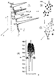
Fig. 1 shows a schematic diagram of the different method
steps of the method according to the invention,
CA 02725519 2010-10-01
- 12 -
Fig. 2 shows an exemplary backscattered signal with
temporal resolution of a laser beam emitted by a laser
scanner, with the evaluation of which a three-dimensional
segmentation can be carried out,
Fig. 3 shows a schematic diagram of the division of a
section of a wood volume into a regular grid of volume
elements, and
Fig. 4a to 4c show exemplary embodiments of resulting
segmentations of trees by three-dimensional division of a
point cloud determined in a computer-aided manner.
Fig. 1 schematically shows the method for computer-aided
segmentation of an environment into individual objects. In
the example below, the method is described with reference
to a segmentation of a wood into individual trees. The
method according to the invention is however not restricted
to this specific application, but can be used generally for
segmenting an environment into individual objects, for
example houses, bushes, hail distribution in clouds and the
like.
The method for three-dimensional segmentation of a wood
into individual trees emanates from scanning the wood with
electromagnetic beams. The electromagnetic radiation can be
of a coherent or incoherent nature, with coherent laser
beams preferably being used. Scanning can take place in an
airborne manner using flights over the area, in a
satellite-aided manner or terrestrially. A full waveform
laser scanner is preferably used for scanning the wood with
electromagnetic radiation. Full waveform laser scanners are
able to record not only main pulses but the entire
backscattered signal, shown in Fig. 2, with temporal
resolution. The diagram in Fig. 2 corresponds to the
situation illustrated at "1" in Fig. 1. A laser beam which
CA 02725519 2010-10-01
- 13 -
is emitted by the laser scanner is drawn in by way of
example, the radiation direction of which is indicated by
r,.
Spatial co-ordinates xl, yl, z, of points X, (i = 1 ,...,
NR) which represent object or tree parts and backscatter
the electromagnetic signal can be defined from the signal
transit times and the known radiation direction of the
laser scanner. In the exemplary embodiment according to
Fig. 1, a total of five such points X1, X2, X5 are
shown by way of example at "1". These points which
represent the tree parts are distributed irregularly on an
axis which corresponds to the direction r, of the radiated
laser beam. The radiation at the points X1, X2, ..., X5 are
backscattered in different ways. The backscatter signal is
labelled SIG R and has a different amplitude depending on
the type of backscattering. Precisely this, as well as
weaker backscattering which is caused for example by leaves
or branches, is recorded by the use of a full waveform
laser scanner. For example, the point X5 represents the
tree crown and thus the highest point of a tree. In
contrast, the points Xi, ..., X4 represent branches or
leaves of one or a plurality of trees. The point X5 for
example represents the ground, because of which a
backscattering of particularly great intensity is present.
The identification of what type the backscattering is takes
place by decomposing the backscattered signal SIG R into a
series of Gaussian functions as basic functions. This
signal is labelled in Fig. 1 and Fig. 2 with SIG RF. The
total signal is defined as follows:
1.7
R
X 2o7-'
S(X) = 4,e
In
te
i=1
In this case,
CA 02725519 2010-10-01
- 14 -
s(x): represents the total signal,
NR: represents the number of Gaussian functions, which
corresponds to the number of the determined points Xõ
A,: represents the amplitude of the i-th Gaussian
function,
x: represents any position in the direction r, of the
laser beam,
X,: represents the position of the i-th Gaussian
function in the direction r, of the laser beam, which
corresponds to the determined point,
LI1: represents the standard deviation of the i-th
Gaussian function.
For each of the points X, the respective spatial co-
ordinates x, y, z, in the Cartesian co-ordinate system
shown schematically at "1" in Fig. 1 and in Fig. 2 are
determined with a known reference point, preferably at the
bottom of the environment to be recorded. A feature vector
is assigned to each of the points X, which feature vector
comprises at least the spatial co-ordinates x, y, z, of
the point in question. The entirety of all the points
determined by the scanning process is labelled as the point
cloud PW, which is shown schematically without a co-
ordinate system at "2" in Fig. 1. The points which are
produced from a multiplicity of laser beams are generally
indicated with P.
Furthermore, further properties of the backscattering
points X, can be defined from the total signal s(x). These
are as further features in particular a pulse width W, =
= v12;r0-
i 1- 7
201 and its intensity .
These further
features are indicated schematically using the Gaussian
function of the point X2 in Fig. 1 and Fig. 2. This
produces feature vectors fl with corresponding additional
information:
CA 02725519 2010-10-01
- 15 -
fT '= (Xi - - TT )-
where i = 1,...,NR.
In order to make the visualisation of the points determined
from a multiplicity of laser beams easier and to accelerate
subsequent calculations, it is expedient to divide the
space recorded by the laser scanner into a predefined
spatial grid of voxels Vx. In this case the points of the
point cloud PW are allocated to the respective voxels Vx
according to the spatial co-ordinates xl, yl, z1. This is
shown schematically in Fig. 3. If a plurality of points
coincide in one voxel Vx, they are expediently combined. In
particular their intensities and pulse widths are averaged
in the process.
In a subsequent processing step, a general distance measure
is defined:
- f
The general distance measure d(i, j) expresses the
similarity between two feature vectors fl and fi of two
points. If the feature vectors of two points only comprise
their spatial co-ordinates, for example the Euclidian
distance can be used as the norm for defining the general
distance measure according to the following formula:
d(i,j)= ¨y,) - -4 ) .
- r
In this case it is advantageous to use, in addition to the
spatial co-ordinates, corresponding prior knowledge about
the typical elongate shape of a tree differently in the
used norm, as well as other, point-related features from
CA 02725519 2010-10-01
- 16 -
the feature vectors. This can be realised for example by a
combined distance measure:
c(i, J.) _
- _ =
where
F(i-
j)-= f / cr-r:
,
AT 2
X 1) = ?.1 1 CT AT
,
Z
j) = d.z
- f. .\
Gki, 1)- dG
07G.
In this case F(i, j) takes into account a distance norm on
the basis of the feature vectors, fl, X(i, j) takes into
account the spatial distance with respect to the x and y
co-ordinates of the points, Z(i, j) takes into account the
vertical distance of the points (corresponding to the
typical elongate shape of a tree). G(i, j) can be used to
take into account further added information. The effects of
the various distance measures can be weighted by means of
the respective parameters Of, Exyr EZ and EG. G(i, j) makes
it possible to consider the points P within the point cloud
PW locally. In this case, in particular further features
from local environments around the respective points can be
taken into account by defining contributions from points
from a specific respective neighbourhood and adding them to
the feature vectors. These can be in particular information
about the uniformity of the distribution of the pulse width
and intensity over a certain volume range or a measure of
the concentration of the points in a selected environment
region. It is also possible using 1i, j) to include in the
method according to the invention already known
CA 02725519 2010-10-01
- 17 -
information, such as tree positions, which has been defined
with other methods, as prior knowledge.
In a subsequent step, which is indicated schematically with
"3" in Fig. 1, the segmentation of the trees takes place.
In this method step the points P or their feature vectors
from the point cloud PW which belong to each tree are
combined. This takes place on the basis of the already
determined distance measure for the feature vectors. To
this end, a global cost function which takes into account
the distances of all the points or feature vectors from
each other is introduced. Then the cost function is
minimised by decomposing the point cloud PW into disjoint
subsets Si, i = 1,...,c (that is, the segments to be
determined).
In a simple case, the cost function can be minimised as the
sum of all the distances of the points xi from each other
within the respective segments Si over all the segments Si:
'I.J11-4j1;jjESK
In this case E indicates the sum of the segment energies.
The objective is the minimisation of the sum of the segment
energies for the defined segments Si.
A simple clustering method such as k-means, as is published
for example in [6] is for example suitable for minimising
the global cost function. This clustering method is however
of a heuristic nature and can get caught in local minimums
of the cost function. This has the consequence that the
globally optimum allocation of the points to the defined
segments does not necessarily take place. A further
disadvantage consists in that the number of the segments c
is to be specified.
CA 02725519 2010-10-01
- 18 -
It is therefore advantageous to apply the costs of the
Normalised-Cut as the cost function to the tree
segmentation. This method is described for example in [7].
In this method all the feature vectors are interpreted as
elements of the node set V in a graph G = {V, El which is
to be drawn. The elements of the edge set E form the
distances d(i, j) = wij of one of the above-defined
distance measures. The objective is thus the division of
the graph into two disjoint node sets A: = S1 and B: = S2
in such a manner that the similarities between the elements
are in each case maximised in the node sets A and B and at
the same time the similarities between the elements from
different subsets are minimised. The cost function is thus
NCi-1 ( B)
It(A,
Assoc(A,TI Assoc( B.F
where
B)¨ v
iGA,JGB
is the sum of all the weightings
Ass cc-1,0=
between the segments A and B, and
is the sum of all the weightings of edges which end in the
segment A.
The minimal NCut measure and thus the division of the
points into the two subsets A and B is found by the
solution of a generalised eigenvalue problem (D - W)y =
ny, where the matrix W is formed by all the weightings wij
i)
1.1
and is The solution, that is, the
eigenvector y for the second smallest eigenvalue 11
consists after binarisation over a threshold of the values
CA 02725519 2010-10-01
- 19 -
(+1,-1), which indicates the allocation of the feature
vectors or the points.
This method optimally minimises the given cost measure, in
contrast to previously mentioned k-means methods, which are
however also applicable in principle. A further advantage
consists in that the number c of the segments does not have
to be explicitly specified, but is given implicitly as a
termination criterion on repeated iterative application of
the method over a threshold to the NCut measure.
A further advantageous variant for minimising the global
cost function is the use of the graph cut method, which is
described in [8]. The purpose of this method is to find the
two subgraphs or segments, with the graph being formed as
described above. The method selects the two subgraphs in
such a manner that the "flux" between the subgraphs is
maximised. The flux is the sum of all the weights of edges
which connect the subgraphs. This takes place in a similar
manner to traffic capacity calculation tasks for a road
network. This method can also be continued iteratively on
the subgraphs.
In addition to the already mentioned, supplementary point-
related features (pulse width and intensity) from the
signal of an individual laser beam, it is advantageous to
define further point-related features from local
environments around the points and add them to the feature
vectors. These further point-related features can be
determined from contributions of points from a certain
respective neighbourhood. In the simplest case, further
features can be formed for each point on the basis of the
features of other points from a permanently defined
environment, such as the scattering of the intensities or
the sum of all the intensities. It is also conceivable to
define the feature vector components to be selected by
means of a core-based filtering process:
CA 02725519 2010-10-01
- 20 -
_____________________ ,
1 iii(
, )1õ(( A - X1)i h)
/11(A )= ________
h ______________________________
,1:230X-Xith)
where K(X) indicates a core function, for example a
Gaussian bell curve, and h as the parameter controls the
width of the neighbourhood to be included. The sum in the
denominator over the number of the Gaussian functions is
used for normalisation.
It is furthermore advantageous to exploit a priori
knowledge about trunk positions of trees. This knowledge
can be included in the method according to the invention.
To this end, each point is weighted according to the
general distance measure determined above,
in
d(7iJ.-
correspondence with its minimum horizontal distance
from the closest tree trunk. This means for example, the
closer a point lies to a tree trunk, the greater the
possibility that the point belongs to a certain segment and
thus tree trunk.
Information about positions of tree trunks can for example
be obtained according to the methods described in [9] and
[10] by defining vertical lines in the point cloud and used
in the method according to the invention.
The segmentation of the points P of the point cloud PW is
shown schematically in Fig. 1 at "3". Here, the points P
have been divided into the points P1 of a segment A and
points P2 of a segment B. The result of the segmentation is
schematically illustrated at "4".
Fig. 4a to 4c show exemplary results of segmented trees. In
this case a two-dimensional section of the three-
CA 02725519 2010-10-01
- 21 -
dimensional spatial co-ordinate system is shown in each
case, with a height N being shown over the height axis (z
axis in the co-ordinate system). The abscissa represents
for example the x axis in the defined co-ordinate system
(cf. for example Fig. 2). In Fig. 4a, a fictitious
separating line T is drawn in, which delimits the segments
A and B and the respectively allocated points Pl, P2 from
each other. The separating line T has been determined in
this case by minimising the global cost function E.
Furthermore, two auxiliary lines Li, L2 are drawn in, with
the auxiliary line Li representing a tree trunk of the
segment A and the auxiliary line L2 representing a tree
trunk of the segment B. The auxiliary lines Li, L2 have
been determined for verification of the method by
inspecting the wood section being studied.
In a corresponding manner Fig. 4b illustrates two segments
A, B with a respective tree. In this case the trees have a
different height, which can be determined by the three-
dimensional segmentation of the method according to the
invention. The auxiliary lines Li, L2 in turn represent
tree trunks and are used to verify the success of the
segmentation which has been carried out.
In Fig. 4c, a number of six trees has been determined as
the result of the segmentation, which are represented
visually by the differently coloured points Pi, ..., P6.
The tree trunks represented by auxiliary lines Li to L6 are
again shown for the purpose of verification in a similar
manner to the diagram of the preceding exemplary
embodiments in Fig. 4a and 4b. The position and height of
the tree trunks has been determined by inspecting the wood
section being studied.
As can be seen from these exemplary embodiments, underlying
trees which were concealed/invisible for the previous
CA 02725519 2010-10-01
- 22 -
methods of segmentation can also be successfully segmented
and identified with the method according to the invention.
The information determined by the method according to the
invention can be used not only for quantitative purposes,
but also as a basis for three-dimensional diagrams of tree
groups. For example, two-dimensional, coloured maps of
wooded areas with certain properties can be created on the
basis of the information.
The method makes it possible to count trees in a wooded
area. The size distribution and the local distribution of
the trees can be determined. Furthermore, a classification
of the trees into different tree species could take place.
It is likewise possible to determine the quantity of wood
using the number and the volume of the tree species.
If the method according to the invention is repeated at
regular intervals, the chronological development of a wood
can be carried out by comparing a plurality of evaluations
from different times.
The segmentation of the trees does not necessarily have to
take place in a wooded area. Tree recognition can likewise
be carried out in urban areas, by means of which trees can
be distinguished from houses.
The method according to the invention is likewise suitable
for recording and segmenting trees in orchards or bushes in
agricultural areas.
Furthermore, recording of houses in urban areas or hail
distribution in clouds for the purpose of storm prediction
can be realised with the method.
References
CA 02725519 2010-10-01
- 23 -
[1] Hyyppa, J., Kelle, O., Lehikoinen, M., Inkinen, M.,
2001, "A segmentation-based method to retrieve stem volume
estimates from 3-D tree height models produced by laser
scanners", IEEE Transactions on Geoscience and remote
Sensing, 39:969-975
[2] Solberg, S., Naesset, E., Bollandsas, 0. M., 2006,
"Single Tree Segmentation Using Airborne Laser Scanner Data
in a Structurally Heterogeneous Spruce Forest",
Photogrammetric Engineering & Remote Sensing, Vol. 72, No.
12, December 2006, pages 1369-1378
[3] Vincent, L., Soille, P., 1991, "Watersheds in Digital
Spaces: An Efficient Algorithm Based on Immersion
Simulations", IEEE Transactions of Pattern Analysis and
Machine Intelligence, Vol. 13, No. 6, June 1991, pages 583-
598
[4] Persson, A., Holmgren, J. and SOderman, U., 2002,
"Detecting and measuring individual trees using an airborne
laserscanner" Photogrammetric Engineering & Remote Sensing
68(9), pages 925-932
[5] Wang, Y., Weinacker, H., Koch, B., 2007, "Development
of a Procedure for Vertical Structure Analysis and 3D-
Single Tree Extraction within Forests Based on Lidar Point
Cloud", Proceedings of the ISPRS Workshop Laser Scanning
2007 and SilviLaser 2007, Vol. XXXVI, PART 3/W52, 12th ¨
14th September 2007, Espoo, pages 419 ¨ 423
[6] Duda, R.O., Hart, P.E., Stork, D.G., 2000, "Pattern
Classification", second edition, Wiley&Sons, page 526 ff
[7] Shi, J., Malik, J., 2000, "Normalized cuts and image
segmentation", IEEE Transactions on Pattern Analysis and
Machine Intelligence, 22, pages 888-905
[8] Boykov Y., Veksler O., Zabih R., "Fast Approximate
Energy Minimization via Graph Cuts", IEEE Trans. on Pattern
Analysis and Machine Intelligence, Vol. 23, No. 11, 2001
[9] Reitberger, J., Krzystek, P., Stilla, U., "Combined
Tree Segmentation and Stem Detection using Full Waveform
LIDAR Data", ISPRS Workshop "SilviLaser", September 2007,
Helsinki
CA 02725519 2010-10-01
- 24 -
[10] Reitberger, J., Heurich, M., Krzystek, P., Stilla, U.,
"Single Tree Detection in Forest Areas with High-Density
LIDAR Data", ISPRS Workshop "Photogrammetric Image
Analysis", September 2007, Munich