Note: Descriptions are shown in the official language in which they were submitted.
CA 02725780 2010-11-25
WO 2010/040404 PCT/EP2008/063484
IMPROVEMENTS RELATING TO NAVIGATION APPARATUS USED IN-VEHICLE
Field of the Invention
The present invention relates to the field of navigation devices for in-
vehicle use,
and methods associated therewith. Such devices may, for example, be installed
as
integral vehicle equipment, or may be portable devices configured or
configurable for in-
vehicle use.
Background to the Invention
Portable computing devices, for example Portable Navigation Devices (PNDs)
that include GPS (Global Positioning System) signal reception and processing
functionality are well known and are widely employed as in-car or other
vehicle
navigation systems.
In general terms, a modern PND comprises a processor, memory (at least one of
volatile and non-volatile, and commonly both), and map data stored within said
memory.
The processor and memory cooperate to provide an execution environment in
which a
software operating system may be established, and additionally it is
commonplace for
one or more additional software programs to be provided to enable the
functionality of
the PND to be controlled, and to provide various other functions.
Typically these devices further comprise one or more input interfaces that
allow a
user to interact with and control the device, and one or more output
interfaces by means
of which information may be relayed to the user. Illustrative examples of
output
interfaces include a visual display and a speaker for audible output.
Illustrative
examples of input interfaces include one or more physical buttons to control
on/off
operation or other features of the device (which buttons need not necessarily
be on the
device itself but could be on a steering wheel if the device is built into a
vehicle), and a
microphone for detecting user speech. In one particular arrangement, the
output
interface display may be configured as a touch sensitive display (by means of
a touch
sensitive overlay or otherwise) additionally to provide an input interface by
means of
which a user can operate the device by touch.
Devices of this type will also often include one or more physical connector
interfaces by means of which power and optionally data signals can be
transmitted to
and received from the device, and optionally one or more wireless
transmitters/receivers
to allow communication over cellular telecommunications and other signal and
data
networks, for example Bluetooth, Wi-Fi, Wi-Max, GSM, UMTS and the like.
PNDs of this type also include a GPS antenna by means of which satellite-
CA 02725780 2010-11-25
WO 2010/040404 PCT/EP2008/063484
2
broadcast signals, including location data, can be received and subsequently
processed
to determine a current location of the device.
The PND may also include electronic gyroscopes and accelerometers which
produce signals that can be processed to determine the current angular and
linear
acceleration, and in turn, and in conjunction with location information
derived from the
GPS signal, velocity and relative displacement of the device and thus the
vehicle in
which it is mounted. Typically, such features are most commonly provided in in-
vehicle
navigation systems, but may also be provided in PNDs if it is expedient to do
so.
The utility of such PNDs is manifested primarily in their ability to determine
a
route between a first location (typically a start or current location) and a
second location
(typically a destination). These locations can be input by a user of the
device, by any of
a wide variety of different methods, for example by postcode, street name and
house
number, previously stored "well known" destinations (such as famous locations,
municipal locations (such as sports grounds or swimming baths) or other points
of
interest), and favourite or recently visited destinations.
Typically, the PND is enabled by software for computing a "best" or "optimum"
route between the start and destination address locations from the map data. A
"best" or
"optimum" route is determined on the basis of predetermined criteria and need
not
necessarily be the fastest or shortest route. The selection of the route along
which to
guide the driver can be very sophisticated, and the selected route may take
into account
existing, predicted and dynamically and/or wirelessly received traffic and
road
information, historical information about road speeds, and the driver's own
preferences
for the factors determining road choice (for example the driver may specify
that the route
should not include motorways or toll roads).
In addition, the device may continually monitor road and traffic conditions,
and
offer to or choose to change the route over which the remainder of the journey
is to be
made due to changed conditions. Real time traffic monitoring systems, based on
various
technologies (e.g. mobile phone data exchanges, fixed cameras, GPS fleet
tracking) are
being used to identify traffic delays and to feed the information into
notification systems.
PNDs of this type may typically be mounted on the dashboard or windscreen of a
vehicle, but may also be formed as part of an on-board computer of the vehicle
radio or
indeed as part of the control system of the vehicle itself. The navigation
device may also
be part of a hand-held system, such as a PDA (Portable Digital Assistant), a
media
player, a mobile phone or the like, and in these cases, the normal
functionality of the
hand-held system is extended by means of the installation of software on the
device to
perform both route calculation and navigation along a calculated route.
CA 02725780 2010-11-25
WO 2010/040404 PCT/EP2008/063484
3
Route planning and navigation functionality may also be provided by a desktop
or
mobile computing resource running appropriate software. For example, the Royal
Automobile Club (RAC) provides an on-line route planning and navigation
facility at
http://www.rac.co.uk, which facility allows a user to enter a start point and
a destination
whereupon the server with which the user's computing resource is communicating
calculates a route (aspects of which may be user specified), generates a map,
and
generates a set of exhaustive navigation instructions for guiding the user
from the
selected start point to the selected destination. The facility also provides
for pseudo
three-dimensional rendering of a calculated route, and route preview
functionality which
simulates a user travelling along the route and thereby provides the user with
a preview
of the calculated route.
In the context of a PND, once a route has been calculated, the user interacts
with
the navigation device to select the desired calculated route, optionally from
a list of
proposed routes. Optionally, the user may intervene in, or guide the route
selection
process, for example by specifying that certain routes, roads, locations or
criteria are to
be avoided or are mandatory for a particular journey. The route calculation
aspect of the
PND forms one primary function, and navigation along such a route is another
primary
function.
During navigation along a calculated route, it is usual for such PNDs to
provide
visual and/or audible instructions to guide the user along a chosen route to
the end of
that route, i.e. the desired destination. It is also usual for PNDs to display
map
information on-screen during the navigation, such information regularly being
updated
on-screen so that the map information displayed is representative of the
current location
of the device, and thus of the user or user's vehicle if the device is being
used for in-
vehicle navigation.
An icon displayed on-screen typically denotes the current device location, and
is
centred with the map information of current and surrounding roads in the
vicinity of the
current device location and other map features also being displayed.
Additionally,
navigation information may be displayed, optionally in a status bar above,
below or to
one side of the displayed map information, examples of navigation information
include a
distance to the next deviation from the current road required to be taken by
the user, the
nature of that deviation possibly being represented by a further icon
suggestive of the
particular type of deviation, for example a left or right turn. The navigation
function also
determines the content, duration and timing of audible instructions by means
of which
the user can be guided along the route. As can be appreciated a simple
instruction such
as "turn left in 100 m" requires significant processing and analysis. As
previously
CA 02725780 2010-11-25
WO 2010/040404 PCT/EP2008/063484
4
mentioned, user interaction with the device may be by a touch screen, or
additionally or
alternately by steering column mounted remote control, by voice activation or
by any
other suitable method.
A further important function provided by the device is automatic route re-
calculation in the event that: a user deviates from the previously calculated
route during
navigation (either by accident or intentionally); real-time traffic conditions
dictate that an
alternative route would be more expedient and the device is suitably enabled
to
recognize such conditions automatically, or if a user actively causes the
device to
perform route re-calculation for any reason.
It is also known to allow a route to be calculated with user defined criteria;
for
example, the user may prefer a scenic route to be calculated by the device, or
may wish
to avoid any roads on which traffic congestion is likely, expected or
currently prevailing.
The device software would then calculate various routes and weigh more
favourably
those that include along their route the highest number of points of interest
(known as
POls) tagged as being for example of scenic beauty, or, using stored
information
indicative of prevailing traffic conditions on particular roads, order the
calculated routes
in terms of a level of likely congestion or delay on account thereof. Other
POI-based and
traffic information-based route calculation and navigation criteria are also
possible.
Although the route calculation and navigation functions are fundamental to the
overall utility of PNDs, it is possible to use the device purely for
information display, or
"free-driving", in which only map information relevant to the current device
location is
displayed, and in which no route has been calculated and no navigation is
currently
being performed by the device. Such a mode of operation is often applicable
when the
user already knows the route along which it is desired to travel and does not
require
navigation assistance.
Devices of the type described above, for example the 920T model manufactured
and supplied by TomTom International B.V., provide a reliable means for
enabling users
to navigate from one position to another. Such devices are of great utility
when the user
is not familiar with the route to the destination to which they are
navigating.
As mentioned above, the memory of the PND stores map data used by the PND
not only to calculate routes and provide necessary navigation instructions to
users, but
also to provide visual information to users through the visual display of the
PND.
As is known in the art, map information can be expressed in a number of ways
and indeed can comprise a number of separate information components, which are
used
in combination by the PND. One aspect of map information is supplementary road
information to provide information additional to the mere location of the
road.
CA 02725780 2010-11-25
WO 2010/040404 PCT/EP2008/063484
Supplementary road information may include information about the road surface,
and
lane width. In general, there are two methods for obtaining map information,
including
the supplementary road information. The first is to purchase the information
from
government authorities and original mapping companies. However, the
completeness,
5 quality and current validity of such information may not be guaranteed. The
second is to
drive a vehicle equipped with special mapping equipment around the road
network to
collect the information using the mapping equipment. For example, the road
surface and
lane width may be determined by dedicated mapping sensors and cameras mounted
on
the vehicle. However, a typical vehicle only has dedicated sensors for
monitoring and
aiding the performance of that vehicle, not mapping-capable measurement
sensors.
Equipping such vehicles with the necessary additional measurement sensors and
cameras for collecting map information is expensive. Moreover, driving the
special
vehicles around an extensive road network to collect mapping information is
time-
consuming and laborious. The task is magnified when trying to prepare accurate
maps
covering several countries. In order to maintain the information up to date,
it is
necessary to send vehicles around a road network on a sufficiently frequent
basis that
any road and lane modifications can be detected before the existing map
information
becomes out of date.
It would be desirable to provide an alternative technique for collecting
supplementary road information.
Summary of the Invention
The present invention is defined in the claims.
The present invention is based on the surprising appreciation that
supplementary
map information can be inferred by analysing statistically information
generated from
standard sensors of a typical vehicle. These sensors have previously been
dismissed
as a reliable source of mapping information, because the sensor outputs are
affected by
a wide variety of different driving conditions and driving events, and
different vehicles
use different types of sensors. However, statistical analysis to identify
information
patterns, can yield supplementary road information that is surprisingly
accurate.
The accuracy of this technique can be enhanced by one or more of:
(a) analysing information from plural sensors of the vehicle in combination to
infer
information not obtainable directly from a single sensor;
(b) analysing information from plural vehicles, so that a more diverse
statistical
picture representing the supplementary map information can be obtained, not
limited to the specific characteristics and sensors of a single vehicle;
CA 02725780 2010-11-25
WO 2010/040404 PCT/EP2008/063484
6
(c) analysing information from the same vehicle making the same journey or at
least
passing the same point again on different occasions.
One technique of the present invention is for a navigation device used in-
vehicle
(either docked with a vehicle or being part of integral in-vehicle equipment)
to log
information obtained from the on-board vehicle sensors normally used to
monitor or aid
vehicle performance. The logged information is later uploaded to a server via
data
communications channel. The server preferably receives similar information
from other
navigation devices used in other vehicles. Statistical analysis of the
uploaded
information is used to infer accurate supplementary road information. The
supplementary road information can be used to generate warnings of driving
hazards,
and to aid route calculations with a preference for route safety.
According to one aspect of the invention, a technique for determining physical
road surface information for a road represented in a digital map, comprises:
providing a plurality of navigation devices for in-vehicle use, each
navigation
device being configured to store information obtained from at least a vehicle
sensor
selected from: a microphone; a vehicle speed sensor; a rain-fall sensor; a
suspension-
travel sensor; a dead-reckoning sensor; a steering sensor;
receiving the stored information from the plurality of navigation devices;
analyzing the received information statistically to determine the physical
road
surface information from the characteristics of the stored information from
the plurality of
navigation devices.
The physical road surface information may be selected from one or more of:
position of pot-holes, position of speed-bumps, road surface roughness, road-
surface
porosity.
According to another specific aspect of the invention, a technique for
determining
lane width of a road, comprises:
providing a plurality of navigation devices for in-vehicle use, each
navigation
device being configured to store information obtained from a steering sensor
of a
respective vehicle representing steering of the vehicle while on the road;
receiving the stored information from the plurality of navigation devices;
analyzing the received information statistically to determine, from the
characteristics of in-lane steering corrections, a value of lane width for
said road.
Other aspects of the invention define independently a navigation device, a
server, and methods of operation for either of these techniques, as well as a
computer
program element for implementing the invention using executable code.
CA 02725780 2010-11-25
WO 2010/040404 PCT/EP2008/063484
7
Advantages of these embodiments are set out hereafter, and further details and
features of each of these embodiments are defined in the accompanying
dependent
claims and elsewhere in the following detailed description.
It is thus possible to provide an apparatus and method capable of deriving
supplementary road information from standard in-vehicle sensors that are not
configured
or intended for mapping. This simplifies the burden of collecting and updating
supplementary map information, as such information can be inferred from
information
fed back by navigation devices to a server. The supplementary map information
can be
used to improve the quality and accuracy of digital maps, and enable a variety
of safety
advantages to be achieved when planning a route.
Brief Description of the Drawings
At least one embodiment of the invention will now be described, by way of
example only, with reference to the accompanying drawings, in which:
Figure 1 is a schematic illustration of an exemplary part of a Global
Positioning
System (GPS) usable by a navigation device;
Figure 2 is a schematic diagram of a communications system for communication
between a navigation device and a server;
Figure 3 is a schematic illustration of electronic components of the
navigation
device of Figure 2 or any other suitable navigation device;
Figure 4 is a schematic diagram of an arrangement of mounting and/or docking a
navigation device;
Fig. 5 is a schematic diagram of a data communications bus on a schematic
floorplan of a vehicle
Figure 6 is a schematic representation of an architectural stack employed by
the
navigation device of Figure 3;
Figure 7 is a schematic representation of the functional parts of the data
loging
module of the application software;
Figure 8 is a schematic plan view showing the principle of deriving lane width
information from driving behaviour;
Figure 9a is a schematic illustration of information recorded in a compressed
stream;
Figure 9b is a schematic illustration of information recorded in an
information
event;
Figure 10 is a schematic plan view showing driving behaviour when encountering
a pothole or speed-bump;
CA 02725780 2010-11-25
WO 2010/040404 PCT/EP2008/063484
8
Figure 11 a is a schematic illustration of information recorded in a
compressed
stream;
Figure 11 b is a schematic illustration of information recorded in an
information
event;
Figure 12a is a schematic graph showing a typical suspension travel signal
when
on a relatively smooth road;
Figure 12b is a schematic graph showing a typical suspension travel signal
when
on a relatively rough road;
Figure 13a is a schematic illustration of information recorded in a compressed
stream;
Figure 13b is a schematic illustration of information recorded in an
information
event;
Figure 14 is a schematic illustration of the difference in the level of sensed
ambient noise for porous and non-porous paved roads;
Figure 15 is a schematic illustration of the difference in the level of sensed
rain-
fall for porous and non-porous roads;
Figure 16a is a schematic illustration of information recorded in a compressed
stream;
Figure 16b is a schematic illustration of information recorded in an
information
event;
Figure 17 is a schematic diagram showing information flow between multiple
navigation devices and a server; and
Figure 18 is a schematic diagram showing information flow for performing route
planning using the supplementary road information.
Detailed Description of Preferred Embodiments
Throughout the following description identical reference numerals will be used
to
identify like parts.
Embodiments of the present invention will now be described with particular
reference to a PND. It should be remembered, however, that the teachings of
the
present invention are not limited to PNDs but are instead universally
applicable to any
type of processing device that is configured to execute navigation software in
a manner
configured for in-vehicle use so as to provide route planning and navigation
functionality.
It follows therefore that in the context of the present application, a
navigation device is
intended to include (without limitation) any type of route planning and
navigation device,
irrespective of whether that device is embodied as a PND, a vehicle such as an
CA 02725780 2010-11-25
WO 2010/040404 PCT/EP2008/063484
9
automobile, or indeed a portable computing resource, for example a portable
personal
computer (PC), a mobile telephone or a Personal Digital Assistant (PDA)
executing route
planning and navigation software.
It will also be apparent from the following that the teachings of the present
invention even have utility in circumstances, where a user is not seeking
instructions on
how to navigate from one point to another, but merely wishes to be provided
with a view
of a given location. In such circumstances the "destination" location selected
by the user
need not have a corresponding start location from which the user wishes to
start
navigating, and as a consequence references herein to the "destination"
location or
indeed to a "destination" view should not be interpreted to mean that the
generation of a
route is essential, that travelling to the "destination" must occur, or indeed
that the
presence of a destination requires the designation of a corresponding start
location.
With the above provisos in mind, the Global Positioning System (GPS) of Figure
1 and the like are used for a variety of purposes. In general, the GPS is a
satellite-radio
based navigation system capable of determining continuous position, velocity,
time, and
in some instances direction information for an unlimited number of users.
Formerly
known as NAVSTAR, the GPS incorporates a plurality of satellites which orbit
the earth
in extremely precise orbits. Based on these precise orbits, GPS satellites can
relay their
location to any number of receiving units.
The GPS system is implemented when a device, specially equipped to receive
GPS data, begins scanning radio frequencies for GPS satellite signals. Upon
receiving
a radio signal from a GPS satellite, the device determines the precise
location of that
satellite via one of a plurality of different conventional methods. The device
will continue
scanning, in most instances, for signals until it has acquired at least three
different
satellite signals (noting that position is not normally, but can be
determined, with only
two signals using other triangulation techniques). Implementing geometric
triangulation,
the receiver utilizes the three known positions to determine its own two-
dimensional
position relative to the satellites. This can be done in a known manner.
Additionally,
acquiring a fourth satellite signal allows the receiving device to calculate
its three
dimensional position by the same geometrical calculation in a known manner.
The
position and velocity data can be updated in real time on a continuous basis
by an
unlimited number of users.
As shown in Figure 1, the GPS system 100 comprises a plurality of satellites
102
orbiting about the earth 104. A GPS receiver 106 receives spread spectrum GPS
satellite data signals 108 from a number of the plurality of satellites 102.
The spread
spectrum data signals 108 are continuously transmitted from each satellite
102, the
CA 02725780 2010-11-25
WO 2010/040404 PCT/EP2008/063484
spread spectrum data signals 108 transmitted each comprise a data stream
including
information identifying a particular satellite 102 from which the data stream
originates.
The GPS receiver 106 generally requires spread spectrum data signals 108 from
at least
three satellites 102 in order to be able to calculate a two-dimensional
position. Receipt
5 of a fourth spread spectrum data signal enables the GPS receiver 106 to
calculate, using
a known technique, a three-dimensional position.
Turning to Figure 2, a navigation device 200 comprising or coupled to the GPS
receiver device 106, is capable of establishing a data session, if required,
with network
hardware of a "mobile" or telecommunications network via a mobile device (not
shown),
10 for example a mobile telephone, PDA, and/or any device with mobile
telephone
technology, in order to establish a digital connection, for example a digital
connection via
known Bluetooth technology. Thereafter, through its network service provider,
the
mobile device can establish a network connection (through the Internet for
example) with
a server 150. As such, a "mobile" network connection can be established
between the
navigation device 200 (which can be, and often times is, mobile as it travels
alone and/or
in a vehicle) and the server 150 to provide a "real-time" or at least very "up
to date"
gateway for information.
The establishing of the network connection between the mobile device (via a
service provider) and another device such as the server 150, using the
Internet for
example, can be done in a known manner. In this respect, any number of
appropriate
data communications protocols can be employed, for example the TCP/IP layered
protocol. Furthermore, the mobile device can utilize any number of
communication
standards such as CDMA2000, GSM, IEEE 802.11 a/b/c/g/n, etc.
Hence, it can be seen that the internet connection may be utilised, which can
be
achieved via data connection, via a mobile phone or mobile phone technology
within the
navigation device 200 for example.
Although not shown, the navigation device 200 may, of course, include its own
mobile telephone technology within the navigation device 200 itself (including
an
antenna for example, or optionally using the internal antenna of the
navigation device
200). The mobile phone technology within the navigation device 200 can include
internal components, and/or can include an insertable card (e.g. Subscriber
Identity
Module (SIM) card), complete with necessary mobile phone technology and/or an
antenna for example. As such, mobile phone technology within the navigation
device
200 can similarly establish a network connection between the navigation device
200 and
the server 150, via the Internet for example, in a manner similar to that of
any mobile
device.
CA 02725780 2010-11-25
WO 2010/040404 PCT/EP2008/063484
11
For telephone settings, a Bluetooth enabled navigation device may be used to
work correctly with the ever changing spectrum of mobile phone models,
manufacturers,
etc., model/manufacturer specific settings may be stored on the navigation
device 200
for example. The data stored for this information can be updated.
In Figure 2, the navigation device 200 is depicted as being in communication
with
the server 150 via a generic communications channel 152 that can be
implemented by
any of a number of different arrangements. The communication channel 152
generically
represents the propagating medium or path that connects the navigation device
200 and
the server 150. The server 150 and the navigation device 200 can communicate
when a
connection via the communications channel 152 is established between the
server 150
and the navigation device 200 (noting that such a connection can be a data
connection
via mobile device, a direct connection via personal computer via the internet,
etc.).
The communication channel 152 is not limited to a particular communication
technology. Additionally, the communication channel 152 is not limited to a
single
communication technology; that is, the channel 152 may include several
communication
links that use a variety of technology. For example, the communication channel
152 can
be adapted to provide a path for electrical, optical, and/or electromagnetic
communications, etc. As such, the communication channel 152 includes, but is
not
limited to, one or a combination of the following: electric circuits,
electrical conductors
such as wires and coaxial cables, fibre optic cables, converters, radio-
frequency (RF)
waves, the atmosphere, free space, etc. Furthermore, the communication channel
152
can include intermediate devices such as routers, repeaters, buffers,
transmitters, and
receivers, for example.
In one illustrative arrangement, the communication channel 152 includes
telephone and computer networks. Furthermore, the communication channel 152
may
be capable of accommodating wireless communication, for example, infrared
communications, radio frequency communications, such as microwave frequency
communications, etc. Additionally, the communication channel 152 can
accommodate
satellite communication.
The communication signals transmitted through the communication channel 152
include, but are not limited to, signals as may be required or desired for
given
communication technology. For example, the signals may be adapted to be used
in
cellular communication technology such as Time Division Multiple Access
(TDMA),
Frequency Division Multiple Access (FDMA), Code Division Multiple Access
(CDMA),
Global System for Mobile Communications (GSM), etc. Both digital and analogue
signals can be transmitted through the communication channel 152. These
signals may
CA 02725780 2010-11-25
WO 2010/040404 PCT/EP2008/063484
12
be modulated, encrypted and/or compressed signals as may be desirable for the
communication technology.
The server 150 includes, in addition to other components which may not be
illustrated, a processor 154 operatively connected to a memory 156 and further
operatively connected, via a wired or wireless connection 158, to a mass data
storage
device 160. The mass storage device 160 contains a store of navigation data
and map
information, and can again be a separate device from the server 150 or can be
incorporated into the server 150. The processor 154 is further operatively
connected to
transmitter 162 and receiver 164, to transmit and receive information to and
from
navigation device 200 via communications channel 152. The signals sent and
received
may include data, communication, and/or other propagated signals. The
transmitter 162
and receiver 164 may be selected or designed according to the communications
requirement and communication technology used in the communication design for
the
navigation system 200. Further, it should be noted that the functions of
transmitter 162
and receiver 164 may be combined into a single transceiver.
As mentioned above, the navigation device 200 can be arranged to
communicate with the server 150 through communications channel 152, using
transmitter 166 and receiver 168 to send and receive signals and/or data
through the
communications channel 152, noting that these devices can further be used to
communicate with devices other than server 150. Further, the transmitter 166
and
receiver 168 are selected or designed according to communication requirements
and
communication technology used in the communication design for the navigation
device
200 and the functions of the transmitter 166 and receiver 168 may be combined
into a
single transceiver as described above in relation to Figure 2. Of course, the
navigation
device 200 comprises other hardware and/or functional parts, which will be
described
later herein in further detail.
Software stored in server memory 156 provides instructions for the processor
154 and allows the server 150 to provide services to the navigation device
200. One
service provided by the server 150 involves processing requests from the
navigation
device 200 and transmitting navigation data from the mass data storage 160 to
the
navigation device 200. Another service that can be provided by the server 150
includes
processing the navigation data using various algorithms for a desired
application and
sending the results of these calculations to the navigation device 200. A
further service
that can be provided by the server 150 is the processing of information
collected by the
navigation device 200, as described later.
The server 150 constitutes a remote source of data accessible by the
navigation
CA 02725780 2010-11-25
WO 2010/040404 PCT/EP2008/063484
13
device 200 via a wireless channel. The server 150 may include a network server
located
on a local area network (LAN), wide area network (WAN), virtual private
network (VPN),
etc.
The server 150 may include a personal computer such as a desktop or laptop
computer, and the communication channel 152 may be a cable connected between
the
personal computer and the navigation device 200. Alternatively, a personal
computer
may be connected between the navigation device 200 and the server 150 to
establish an
internet connection between the server 150 and the navigation device 200.
The navigation device 200 may be provided with information from the server 150
via information downloads which may be periodically updated automatically or
upon a
user connecting the navigation device 200 to the server 150 and/or may be more
dynamic upon a more constant or frequent connection being made between the
server
150 and navigation device 200 via a wireless mobile connection device and
TCP/IP
connection for example. For many dynamic calculations, the processor 154 in
the server
150 may be used to handle the bulk of processing needs, however, a processor
(not
shown in Figure 2) of the navigation device 200 can also handle much
processing and
calculation, oftentimes independent of a connection to a server 150.
Referring to Figure 3, it should be noted that the block diagram of the
navigation
device 200 is not inclusive of all components of the navigation device, but is
only
representative of many example components. The navigation device 200 is
located
within a housing (not shown). The navigation device 200 includes a processing
resource
comprising, for example, the processor 202 mentioned above, the processor 202
being
coupled to an input device 204 and a display device, for example a display
screen 206.
Although reference is made here to the input device 204 in the singular, the
skilled
person should appreciate that the input device 204 represents any number of
input
devices, including a keyboard device, voice input device, touch panel and/or
any other
known input device utilised to input information. Likewise, the display screen
206 can
include any type of display screen such as a Liquid Crystal Display (LCD), for
example.
In one arrangement, one aspect of the input device 204, the touch panel, and
the
display screen 206 are integrated so as to provide an integrated input and
display
device, including a touchpad or touchscreen input 250 (Figure 4) to enable
both input of
information (via direct input, menu selection, etc.) and display of
information through the
touch panel screen so that a user need only touch a portion of the display
screen 206 to
select one of a plurality of display choices or to activate one of a plurality
of virtual or
"soft" buttons. In this respect, the processor 202 supports a Graphical User
Interface
(GUI) that operates in conjunction with the touchscreen.
CA 02725780 2010-11-25
WO 2010/040404 PCT/EP2008/063484
14
In the navigation device 200, the processor 202 is operatively connected to
and
capable of receiving input information from input device 204 via a connection
210, and
operatively connected to at least one of the display screen 206 and the output
device
208, via respective output connections 212, to output information thereto. The
navigation device 200 may include an output device 208, for example an audible
output
device (e.g. a loudspeaker). As the output device 208 can produce audible
information
for a user of the navigation device 200, it is should equally be understood
that input
device 204 can include a microphone and software for receiving input voice
commands
as well. Further, the navigation device 200 can also include any additional
input device
204 and/or any additional output device, such as audio input/output devices
for example.
The processor 202 is operatively connected to memory 214 via connection 216
and is further adapted to receive/send information from/to input/output (I/O)
ports 218 via
connection 220, wherein the I/O port 218 is connectible to an I/O device 222
external to
the navigation device 200. The external I/O device 222 may include, but is not
limited to
an external listening device, such as an earpiece for example. The connection
to I/O
device 222 can further be a wired or wireless connection to any other external
device
such as a car stereo unit for hands-free operation and/or for voice activated
operation for
example, for connection to an earpiece or headphones, and/or for connection to
a
mobile telephone for example, wherein the mobile telephone connection can be
used to
establish a data connection between the navigation device 200 and the Internet
or any
other network for example, and/or to establish a connection to a server via
the Internet
or some other network for example.
Figure 3 further illustrates an operative connection between the processor 202
and an antenna/receiver 224 via connection 226, wherein the antenna/receiver
224 can
be a GPS antenna/receiver for example. It should be understood that the
antenna and
receiver designated by reference numeral 224 are combined schematically for
illustration, but that the antenna and receiver may be separately located
components,
and that the antenna may be a GPS patch antenna or helical antenna for
example.
It will, of course, be understood by one of ordinary skill in the art that the
electronic components shown in Figure 3 are powered by one or more power
sources
(not shown) in a conventional manner. As will be understood by one of ordinary
skill in
the art, different configurations of the components shown in Figure 3 are
contemplated.
For example, the components shown in Figure 3 may be in communication with one
another via wired and/or wireless connections and the like. Thus, the
navigation device
200 described herein can be a portable or handheld navigation device 200.
In addition, the portable or handheld navigation device 200 of Figure 3 can be
CA 02725780 2010-11-25
WO 2010/040404 PCT/EP2008/063484
connected or "docked" in a known manner to a vehicle such as a bicycle, a
motorbike, a
car or a boat for example. Such a navigation device 200 is then removable from
the
docked location for portable or handheld navigation use.
Referring to Figure 4, the navigation device 200 may be a unit that includes
the
5 integrated input and display device 206 and the other components of Figure 2
(including,
but not limited to, the internal GPS receiver 224, the microprocessor 202, a
power
supply (not shown), memory systems 214, etc.).
The navigation device 200 may sit on an arm 252, which itself may be secured
to
a vehicle dashboard/window/etc. using a suction cup 254. This arm 252 is one
example
10 of a docking station to which the navigation device 200 can be docked. The
navigation
device 200 can be docked or otherwise connected to the arm 252 of the docking
station
by snap connecting the navigation device 200 to the arm 252 for example. The
navigation device 200 may then be rotatable on the arm 252. To release the
connection
between the navigation device 200 and the docking station, a button (not
shown) on the
15 navigation device 200 may be pressed, for example. Other equally suitable
arrangements for coupling and decoupling the navigation device 200 to a
docking station
are well known to persons of ordinary skill in the art.
Referring to Fig. 5, when docked in-vehicle, the navigation device 200
communicates with at least one electronic data bus 300 of the vehicle. The
navigation
device 200 may communicate with the bus 300 by means of an interface unit 301,
either
via a direct connection at the docking station, or via a wireless connection.
For example,
the interface unit 301 may be a wireless interface (e.g. Bluetooth interface)
of the
vehicle. The data bus 300 carries signals between different sensor modules 302
and
control modules 304 of the vehicle, allowing the different units to
communicate. The
modules 302, 304 form part of the vehicle's built in systems for controlling
operation of
the vehicle. Non-limiting examples of the control modules may include the
engine
control unit (ECU) 304a, traction control module 304b, suspension and
stability control
module 304c, airbag control module 304d, windscreen wiper control module 304e,
theft-
prevention module 304f, anti-lock braking module 304g, transmission control
module
304h, cruise-control module 304i, climate-control module 304j, etc. Non-
limiting
examples of sensor modules may include a rain-fall sensor 302a, a steering
position
sensor 302b, one or more suspension travel sensors 302c, an external ambient
temperature sensor 302d, one or more transmission and engine performance
sensors
302e, a microphone 302f, vehicle speed sensor 302g, parking-assist camera
302i, etc.
The sensors may also include a dead-reckoning position sensor 302h for
maintaining a
running estimation of displacement of the vehicle in three-dimensional space.
The data
CA 02725780 2010-11-25
WO 2010/040404 PCT/EP2008/063484
16
bus 300 enables information transfer between the different control units, and
interrogation or receipt of information from the sensors. The data bus 300 may
operate
according to an established data bus protocol, such as the Controller Area
Network bus
(CAN-bus) protocol that is widely used in the automotive industry for
implementing a
distributed communications network. One or more of the sensors 302 may, as an
alternative to, or in addition to, communicating via the bus 300, communicate
with a
respective control unit 304 via a dedicated direct connection (not shown).
Such a direct
connection may be used, for example, where a continuous signal from the sensor
is
required by the control unit, or where the signal is required to be
transmitted over a
secure data path. Not all sensor signals may be available from the bus 300,
but the
types of information used by the present embodiment are generally obtainable
directly,
or indirectly, via the bus 300 and/or the interface unit 301.
Turning to Figure 6, within the navigation device 200, processor 202 and
memory
214 cooperate to support a BIOS (Basic Input/Output System) 282 that functions
as an
interface between functional hardware components 280 of the navigation device
200 and
the software executed by the device. The processor 202 then loads an operating
system 284 from the memory 214, which provides an environment in which
application
software 286 (implementing some or all of the above described route planning
and
navigation functionality) can run. The application software 286 provides an
operational
environment including the GUI that supports core functions of the navigation
device, for
example map viewing, route planning, navigation functions and any other
functions
associated therewith. The application software 286 may include a position
determining
module 288, route planning module 290, map-view generation module 292, and
data-
logging module 294.
In accordance with the principles of the present invention, one of the
functions of
the data-logging module 294 is to monitor information on the data bus 300 of
the vehicle,
and to log information that may be useful for collecting supplementary road
information
for the digital map. The idea is that, although the sensor modules 302 of the
vehicle are
not intended for collecting map information and certainly would not be
specifically
configured for this, the information produced by some of the sensors 302 is
surprisingly
useful for deriving supplementary road information using statistical analysis.
Sensor
data logged by the navigation device is uploaded to a server 150 where data is
pooled
and statistical analysis carried out. The statistical accuracy is greatly
increased by
analysing sensor data collected from the same vehicle travelling the same
route multiple
times, and/or combining together data collected from different vehicles. The
collective
effect of multiple data sources provides surprisingly accurate supplementary
road
CA 02725780 2010-11-25
WO 2010/040404 PCT/EP2008/063484
17
information, much greater than that envisaged possible from the types of
sensor
information normally available in an average vehicle.
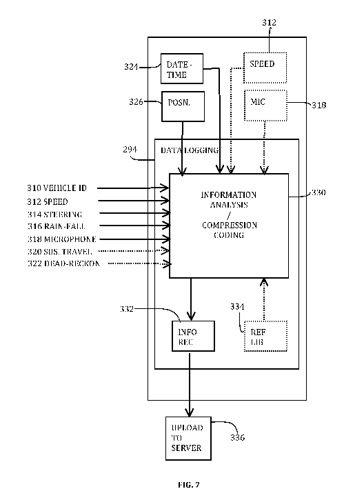
Referring to Fig. 7, the data logging module 294 accepts information inputs
from
at least one information source, that may be selected from:
- Identification information 310 identifying the name and type of vehicle.
Such
information may be obtainable from the interface unit 301.
Vehicle speed 312. This information may be available from the vehicle's speed
sensor 302g, and/or it may be calculated within the navigation device 200 in
accordance
with the rate of change of position.
- Steering wheel angular position 314, available from the vehicle's steering
sensor
302b.
Rain-fall detection 316, available from the vehicle's rain-fall sensor 302a.
Microphone signal 318, indicative of ambient vehicle noise. This signal may be
obtained from the vehicle's microphone 302f, and/or from the navigation
device's
microphone if provided.
Suspension travel 320, obtainable from the vehicle's one or more suspension
travel sensors 302c.
Dead reckoning position 322, obtainable from the vehicle's dead reckoning
sensor 302h, if provided.
- Real date and time information 324. Up to date time and date information is
maintained automatically within the navigation device 200, but may also be
available
from the vehicle's interface unit 301.
Position information 326 obtained within the navigation device, and
representing
the real time position of the vehicle, and matching the position to a road on
a map.
- Image output from the parking-assist camera 302h, if provided.
Not all of the above information sources may be available, nor used by the
navigation device. Alternatively, a greater number of information sources may
be
available and used by the navigation device. The above is merely a list of
information
sources useful for the examples described later.
The data logging module 294 comprises a first signal analysis and/or
compression coding section 330 for receiving the information inputs 310-326,
and a
second information recording section 332. The first section 330 serves to
reduce the
quantity of information to a level that is recordable more efficiently by the
second
section. The second section 332 records the information until the recording is
ready to
be uploaded to the server 150 (at step 336 performed after the logging step
294). The
second section 332 may form part of a trip log recording function of the
navigation
CA 02725780 2010-11-25
WO 2010/040404 PCT/EP2008/063484
18
device. In one form, the first section 330 performs compression coding, so
that the
signal levels are recorded on a continuous basis, but in a compressed format.
Any
suitable compression coding may be used, including but not limited to, run-
length
coding, delta-coding, prediction coding, symbol coding. Alternatively, the
first section
330 may be configured not to compress signals on a continuous basis, but
instead
recognise one or more patterns of interest, as identified by pattern models
stored in a
reference database 334. When a pattern of interest is recognized, an
information
"event" is generated by the first section 330, indicative of the information
and signals that
characterise the event. Examples are described later. Event coding may be more
efficient, because only the events of interest are recorded, and this also
reduces the
amount of data to be uploaded later to the server. However, event coding may
require a
greater processing overhead within the navigation device 200.
Non-limiting examples of how the information sources 310-324 may be used to
derive supplementary road information are now described. The types of
supplementary
road information are useful for determining road hazards, and for quantifying
the safety
of the road, especially in poor weather conditions. This can be used, as
described later,
to aid calculation of a navigation route providing a high degree of safety.
Referring to a first example shown in Fig 8, an indication of the width 340 of
a
lane 342 may be obtained by analysing how a driver corrects the steering of
the vehicle.
Normally, a driver does not drive precisely in the centre of a lane 342, but
instead tends
to sway left and right of the centre-line 344 to within a margin of the lane
periphery. The
driver makes appropriate, usually small, corrections to the steering as the
car drifts
towards a lane periphery either side of the centre-line. Analysis of the
steering
corrections, their frequency and/or amplitude, as well as the vehicle type and
speed,
provides a statistical indication of the lane width 340. The statistical
accuracy is very
much improved by combining information obtained from multiple vehicles and/or
from
the same vehicle, travelling the same route.
Referring to Fig. 9(a), the one way of recording the sensor information is to
compression code continuous information sources selected from: the position
and road
information 326; vehicle speed 312; steering angle 314; and real time and date
information 324. Such information can be analysed later to identify the points
346 (Fig.
8) at which steering corrections are made via the steering wheel position.
Referring to
Fig. 9(b), an alternative technique is to analyse the information signals 326,
312, 314
and 324 in real time and to detect patterns of information corresponding to
the points
346 at which steering corrections are made. An information "event" is
generated for
each steering correction point 346, the event including the characteristic
information
CA 02725780 2010-11-25
WO 2010/040404 PCT/EP2008/063484
19
comprising one or more of: an event identifier 348 indicating the type of
event (lane
steering correction) and/or an event index number; the position and road
information 326
at the point 346; vehicle speed at the point 346; real time and date
information 324 for
the point 346; and amplitude of steering correction (e.g. the angle by which
the steering
wheel is turned to correct the steering). Recording only events instead of
continuous
signals can reduce the quantity of data recorded at step 332, and simplify
later
processing because the significant events have already been discriminated.
The 2nd - 4th examples below illustrate supplementary road information
relating to
the physical surface defining the road.
Referring to Fig. 10, the second example is the detection of driving obstacles
352
in the road surface, such as pot-holes or speed-bumps. With such obstacles,
either the
vehicle will traverse the obstacle, registering significant suspension travel,
or the driver
will manoeuvre around the obstacle 352, as illustrated by the broken lines
350. Both will
normally occur at low speed, but especially the manoeuvre 352. In the case of
suspension travel, two conditions may be discriminated. When traversing a
speed
bump, the suspension is initially compressed as the wheel rises, then extends
as the
wheel descends. When traversing a pot-hole, the opposite occurs. The
suspension is
initially extended as the wheel descends into the hole, then compresses as the
wheel
rises out of the hole. Also, depending on the nature of the suspension travel
information
320, it may be possible to identify which of the vehicle's wheels is currently
traversing
the obstacle, allowing the relative position of the obstacle to be identified.
The
occurrence of such suspension travel or manoeuvre a single time by a single
vehicle
does not indicate unambiguously a speed bump or pot-hole-like obstacle.
However, if
different vehicles all register at the same position, either suspension
travel, or steering to
avoid an obstacle, this is a statistical indication of a permanent feature
such as a speed-
bump or pot-hole in the road. The statistical accuracy is increased the more
the same
vehicle travels the same road, or multiple vehicles travel the same road, each
time
collecting sensor data.
Referring to Fig. 11(a), one way of recording the sensor information is to
compression code continuous information sources selected from: the position
and road
information 326; vehicle speed 312; steering angle 314; suspension travel 320;
and real
time and date information 324. Such information can be analysed later to
identify type of
obstacle or manoeuvre 350 (Fig. 10). Referring to Fig. 11(b), an alternative
technique is
to analyse the information signals 326, 312, 314, 320 and 324 in real time and
to detect
patterns of information corresponding to traversing an obstacle 352, or
manoeuvres 350
for avoiding an obstacle 352. An information "event" is generated for each
detection, the
CA 02725780 2010-11-25
WO 2010/040404 PCT/EP2008/063484
event including characteristic information comprising one or more of: an event
identifier
354 indicating the type of event (driving obstacle); the position and road
information 326
at which the detection is made; vehicle speed 312; real time and date
information 324;
the amount of deviation around the obstacle based on the degree of steering
executed
5 by the driver; the amount and type of suspension travel. Recording only
events instead
of continuous signals can reduce the quantity of data recorded at step 332,
and simplify
later processing because the significant events have already been
discriminated. In the
above example, a single event type is used to detect and describe both
traversing an
obstacle or steering around it, and combines both steering information and
suspension
10 travel information in a single event. Alternatively, if preferred, two
different and
independent events could be used to detect and describe (i) steering around an
obstacle, and (ii) suspension travel when traversing an obstacle. Moreover,
different
events could also be used to detect and describe the different types of
suspension travel
when (i) traversing a pot-hole, and (ii) traversing a speed-bump.
15 Referring to Figs. 12a and b, the third example of supplementary road
information is the condition of the road, whether smooth or rough. A smooth
surface
generally indicates a paved surface (for example with asphalt, tarmac, or
other finished
paving). A non-smooth surface generally indicates a surface of bricks or
unpaved (for
example, a rough or dirt road). Such information is derivable from the
suspension travel
20 information input 320 obtained from the suspension travel sensor(s) 302c.
Referring to
Fig. 12(a), a smooth road is generally indicated by a smooth signal with
occasional
spikes as the suspension moves to accommodate occasional bumps. Referring to
Fig.
12(b), an unpaved road is generally indicated by a non-smooth signal,
resulting from
near continuous movement of the suspension to as the vehicle moves over the
rough
unpaved surface. A similar information pattern is also generated by a dead-
reckoning
sensor, although the signal is then a result of the vehicle motion as the
vehicle bounces
over a rough surface road. Again, the statistical accuracy is greatly improved
the greater
the number of times a vehicle travels the same road, or multiple vehicles
travel the same
road, and each time collect sensor data.
Referring to Fig. 13(a), one way of recording the sensor information is to
compression code continuous information sources selected from: the position
and road
information 326; vehicle speed 312; suspension travel 320 (and/or dead
reckoning
information 322); and real time and date information 324. Such information can
be
analysed later to identify the whether the road surface corresponds to a
smooth or rough
surface. Referring to Fig. 13(b), an alternative technique is to analyse the
information
signals 326, 312, 320/322 and 324 in real time and to detect patterns of
information
CA 02725780 2010-11-25
WO 2010/040404 PCT/EP2008/063484
21
corresponding to the different road surface conditions. An information "event"
is
generated each time that the road surface condition changes significantly,
and/or when
ever the vehicle moves from one road on the map to another road. The event
includes
characteristic information comprising one or more of: an event identifier 354
indicating
the type of event (smooth/rough road surface condition); the position and road
information 326 at which the detection is made; vehicle speed 312; real time
and date
information 324; and type of road surface (smooth or rough). Recording only
events
instead of continuous signals can reduce the quantity of data recorded at step
332, and
simplify later processing because the significant events have already been
discriminated.
Referring to Figs. 14 and 15, the fourth example of supplementary road
information is whether, in the case of a paved road, the paving is a non-
porous or
porous. An example of non-porous paving is traditional tarmac. In the event of
rain,
water does not generally penetrate the surface, and instead flows on top of
the road
surface to surface drains. An example of a porous paving is porous tarmac,
which has
voids between particulate matter to permit rain water to penetrate below the
road
surface. This is considered to aid drainage and reduce the risks of standing
water
pooling on the road surface. While the sensor information might not directly
indicate
whether the current road surface is porous or non-porous, it is nevertheless
possible to
detect when a vehicle traverses from one road type to another. Referring to
Fig. 14, one
indication is provided by the amount of ambient rolling noise of the vehicles
tyres,
obtained from the microphone signal 318. The rolling noise is significantly
reduced
when travelling on a porous road surface, because the voids in a porous
surface absorb
some of the noise. A significant abrupt increase in the ambient road noise
without an
increase in vehicle speed (and/or engine speed) may be an indication that the
vehicle
has traversed from porous to non-porous paving. Conversely, a significant
abrupt
decrease in the ambient road noise without a decrease in vehicle in speed
(and/or
engine speed) may be an indication that the vehicle has traversed from non-
porous to
porous paving. The accuracy of this indication is increased if the same
characteristic is
observed multiple times (e.g. from other vehicles, or from the same vehicle at
a later
time) passing the same point on the road.
Referring to Fig. 15, another indication may be the amount of rain detected by
the rain-fall sensor 302a, in the case that the rain-fall sensor 302a is of a
type
responsive to road spray. The quantity of surface water that collects on the
road surface
is generally greater for non-porous paving, and this may result in
significantly greater
spray as the water is thrown up from the road surface by vehicles' tyres. A
significant
CA 02725780 2010-11-25
WO 2010/040404 PCT/EP2008/063484
22
abrupt increase or decrease in detected rain may indicate traversing from
porous to non-
porous paving, or from non-porous to porous paving, respectively. The accuracy
of this
indication is vehicle has traversed from non-porous to porous paving. The
accuracy of
this indication is increased if the same characteristic is observed multiple
times (e.g.
from other vehicles, or from the same vehicle at a later time) passing the
same point on
the road.
Another indication may be the speed of the vehicle in association with either
an
abrupt change in detected noise and/or rain as described above. It is observed
that,
when traversing from non-porous paving to porous paving, drivers tend to
increase
speed gradually, as the amount of surface water on the road decreases, and the
driver
perceives better driving conditions.
Referring to Fig. 16(a), one way of recording the sensor information is to
compression code continuous information sources selected from: the position
and road
information 326; vehicle speed 312; ambient noise 318; detected rainfall 316;
and real
time and date information 324. Such information can be analysed later to
identify one or
more if the above information patterns corresponding to traversing between
porous and
non-porous road paving. Referring to Fig. 16(b), an alternative technique is
to analyse
the information signals 326, 312, 320/322 and 324 in real time and to detect
patterns of
information corresponding to the different road surface conditions. An
information
"event" is generated each time that one of the above information patterns is
detected
indicative in a change between porous and non-porous road paving. The event
includes
characteristic information comprising one or more of: an event identifier 354
indicating
the type of event (porous/non-porous paving); the position and road
information 326 at
which the detection is made; vehicle speed 312; real time and date information
324; and
the detected information pattern. Recording only events instead of continuous
signals
can reduce the quantity of data recorded at step 332, and simplify later
processing
because the significant events have already been discriminated.
Referring to Fig. 17, the server 150 receives the data logged by multiple
navigation devices 200, by communicating with the navigation devices over
respective
communications channels 152. As explained previously, there are a variety of
possibilities for a navigation device 200 to communicate. One typical
technique is to
connect the navigation device 200 to a user's home computer or PC, and to use
the
computer's internet connection to establish communication with the server 150.
During
such a connection, the logged data is uploaded to the server 150 (step 336 in
Fig. 7).
Updates for the digital map used by the navigation device 200 are downloaded
from the
server, to keep the digital map up to date, and any software or firmware
updates for the
CA 02725780 2010-11-25
WO 2010/040404 PCT/EP2008/063484
23
navigation device can also be downloaded from the server 150. Certain
components of
the server 150 have already been described with respect to Fig. 2. These
components
function to define processing resources in the form of a library 400 for
storing the logged
data received from multiple devices, a statistical analyzer 402 for analyzing
the collection
of logged data in the library 400 to identify information patterns that
provide a reliable
indication of supplementary road information, and a digital map updater 404
for updating
the digital map with the new supplementary road information. The supplementary
road
information be integrated with the digital map, or it may form part of a
separate
information component for use with the digital map. The updated digital map,
or
components thereof, are subsequently downloaded to navigation devices 200
(usually at
a later time, or in a subsequent communications session).
A highly advantageous feature of this embodiment is that the server receives
information automatically from the navigation devices 200. The more frequently
that
users use their navigation devices in their vehicles, and connect to the
server 150 for
updating, the greater the quantity of information provided to the server, and
the more
accurate is the supplementary road information inferred by the analyzer 402.
This
enables supplementary road information to be obtained and kept up to date,
even in the
absence of specially equipped mapping vehicles.
The combination of lane width information, speed information, and other
supplementary road information can enable the type of road to be deduced, for
example,
motorway, through road, local destination road, etc.
Fig. 18 illustrates schematically selected information inputs for a route
calculation
algorithm 410 that may be used in, for example, the navigation device 200. The
information inputs include a start (or current) position/address 412, a
destination
position/address 414 at which the driver desires to arrive, and one or more
waypoints
416 that the driver desires to visit en route. The inputs further include a
selection 418 of
the primary factor(s) for calculation of the route. Examples include optimum
speed (to
arrive at the destination quickly), safety (to minimise accident risk,
especially in poor
weather), toll-free (for avoiding toll roads), scenic (for finding a route
with scenic views or
passing points of interest), and smooth (for avoiding rough roads, or roads
with speed-
bumps or pot-holes that result in accelerated wear of the vehicle). The
information
inputs further include components of the digital map for performing the route
calculation,
including the supplementary road information.
The supplementary road information is especially useful for (i) warning a
driver
of road obstacles and hazards, and (ii) quantifying the safety of a road, to
enhance route
calculation when a driver desires a safe route. For example, the lane width
provides one
CA 02725780 2010-11-25
WO 2010/040404 PCT/EP2008/063484
24
indication of safety. A wider road may be generally equated to a safer road,
as there is
less risk of vehicle contact, and more room to manoeuvre while driving. A
smooth road
is likewise safer than a rough road, and may be more suitable for general-
purpose
vehicles. A porous paved road may be safer than a non-porous paved road in
case of
heavy rain, because a porous road provides better drainage away from the road
surface
and reduces the amount of standing water on the road surface that could
otherwise be
an aquaplaning risk for vehicles. The avoidance of obstacles or hazards such
as pot-
holes likewise increases safety, especially as such hazards may be of limited
visibility in
poor weather. Such information may be used in combination with other safety-
related
information, such as the location of schools and religious centres, where
there is risk of
high pedestrian density.
Additionally, or alternatively, the information regarding road obstacles and
hazards, and the information regarding road condition, is useful for finding a
smooth
route.
Weather forecast information may also be combined in order to judge which
roads might be safest. A pre-trip warning may be generated of potential
driving safety
issues, obstacles and hazards.
If a vehicle includes a camera, such as the parking-assist camera 302i, the
camera output may also be used by the data logging module 294. Having
identified a
signal pattern of interest based on other sensor output information, the
camera image
can be captured and recorded by the data logging module 294. The image may be
later
uploaded to the server 150 to aid information analysis. Additionally or
alternatively, the
server 150 may configure the navigation device with a list of one or more
roads of
interest to be filmed should the navigation device detect that it's position
coincides with
one of the roads of interest.
In addition to route-planning, the ability to detect reliably the occurrence
of pot-
holes in roads enables such information to be provided, on a commercial basis
if
appropriate, to companies or organisations responsible for road maintenance.
Whilst embodiments described in the foregoing detailed description refer to
GPS,
it should be noted that the navigation device may utilise any kind of position
sensing
technology as an alternative to (or indeed in addition to) GPS. For example
the
navigation device may utilise using other global navigation satellite systems
such as the
European Galileo system. Equally, it is not limited to satellite based but
could readily
function using ground based beacons or any other kind of system that enables
the
device to determine its geographic location.
Alternative embodiments of the invention can be implemented as a computer
CA 02725780 2010-11-25
WO 2010/040404 PCT/EP2008/063484
program product for use with a computer system, the computer program product
being,
for example, a series of computer instructions stored on a tangible data
recording
medium, such as a diskette, CD-ROM, ROM, or fixed disk, or embodied in a
computer
data signal, the signal being transmitted over a tangible medium or a wireless
medium,
5 for example, microwave or infrared. The series of computer instructions can
constitute
all or part of the functionality described above, and can also be stored in
any memory
device, volatile or non-volatile, such as semiconductor, magnetic, optical or
other
memory device.
It will also be well understood by persons of ordinary skill in the art that
whilst the
10 preferred embodiment implements certain functionality by means of software,
that
functionality could equally be implemented solely in hardware (for example by
means of
one or more ASICs (application specific integrated circuit)) or indeed by a
mix of
hardware and software. As such, the scope of the present invention should not
be
interpreted as being limited only to being implemented in software.
15 Lastly, it should also be noted that whilst the accompanying claims set out
particular combinations of features described herein, the scope of the present
invention
is not limited to the particular combinations hereafter claimed, but instead
extends to
encompass any combination of features or embodiments herein disclosed
irrespective of
whether or not that particular combination has been specifically enumerated in
the
20 accompanying claims at this time.