Note: Descriptions are shown in the official language in which they were submitted.
CA 02725988 2010-11-25
WO 2010/081563 PCT/EP2009/058824
1
NAVIGATION DEVICE, METHOD & SYSTEM
Field of the Invention
This invention relates to navigation devices and to methods for paying for
services using a navigation device. Illustrative embodiments of the invention
relate to
portable navigation devices (so-called PNDs), in particular PNDs that include
Global
Positioning System (GPS) signal reception and processing functionality. Other
embodiments relate, more generally, to any type of processing device that is
configured
to execute navigation software so as to provide route planning, and preferably
also
navigation, functionality.
Background to the Invention
Portable navigation devices (PNDs) that include GPS (Global Positioning
System) signal reception and processing functionality are well known and are
widely
employed as in-car or other vehicle navigation systems.
In general terms, a modern PNDs comprises a processor, memory (at least one
of volatile and non-volatile, and commonly both), and map data stored within
said
memory. The processor and memory cooperate to provide an execution environment
in
which a software operating system may be established, and additionally it is
commonplace for one or more additional software programs to be provided to
enable the
functionality of the PND to be controlled, and to provide various other
functions.
Typically these devices further comprise one or more input interfaces that
allow a
user to interact with and control the device, and one or more output
interfaces by means
of which information may be relayed to the user. Illustrative examples of
output
interfaces include a visual display and a speaker for audible output.
Illustrative
examples of input interfaces include one or more physical buttons to control
on/off
operation or other features of the device (which buttons need not necessarily
be on the
device itself but could be on a steering wheel if the device is built into a
vehicle), and a
microphone for detecting user speech. In a particularly preferred arrangement
the
output interface display may be configured as a touch sensitive display (by
means of a
touch sensitive overlay or otherwise) to additionally provide an input
interface by means
of which a user can operate the device by touch.
Devices of this type will also often include one or more physical connector
interfaces by means of which power and optionally data signals can be
transmitted to
and received from the device, and optionally one or more wireless
transmitters/receivers
to allow communication over cellular telecommunications and other signal and
data
CA 02725988 2010-11-25
WO 2010/081563 PCT/EP2009/058824
2
networks, for example Wi-Fi, Wi-Max GSM and the like.
PND devices of this type also include a GPS antenna by means of which
satellite-broadcast signals, including location data, can be received and
subsequently
processed to determine a current location of the device.
The PND device may also include electronic gyroscopes and accelerometers
which produce signals that can be processed to determine the current angular
and linear
acceleration, and in turn, and in conjunction with location information
derived from the
GPS signal, velocity and relative displacement of the device and thus the
vehicle in
which it is mounted. Typically such features are most commonly provided in in-
vehicle
navigation systems, but may also be provided in PND devices if it is expedient
to do so.
The utility of such PNDs is manifested primarily in their ability to determine
a
route between a first location (typically a start or current location) and a
second location
(typically a destination). These locations can be input by a user of the
device, by any of
a wide variety of different methods, for example by postcode, street name and
house
number, previously stored "well known" destinations (such as famous locations,
municipal locations (such as sports grounds or swimming baths) or other points
of
interest), and favourite or recently visited destinations.
Typically, the PND is enabled by software for computing a "best" or "optimum"
route between the start and destination address locations from the map data. A
"best" or
"optimum" route is determined on the basis of predetermined criteria and need
not
necessarily be the fastest or shortest route. The selection of the route along
which to
guide the driver can be very sophisticated, and the selected route may take
into account
existing, predicted and dynamically and/or wirelessly received traffic and
road
information, historical information about road speeds, and the driver's own
preferences
for the factors determining road choice (for example the driver may specify
that the route
should not include motorways or toll roads).
In addition, the device may continually monitor road and traffic conditions,
and
offer to or choose to change the route over which the remainder of the journey
is to be
made due to changed conditions. Real time traffic monitoring systems, based on
various
technologies (e.g. mobile phone data exchanges, fixed cameras, GPS fleet
tracking) are
being used to identify traffic delays and to feed the information into
notification systems.
PNDs of this type may typically be mounted on the dashboard or windscreen of a
vehicle, but may also be formed as part of an on-board computer of the vehicle
radio or
indeed as part of the control system of the vehicle itself. The navigation
device may also
be part of a hand-held system, such as a PDA (Portable Digital Assistant) a
media
player, a mobile phone or the like, and in these cases, the normal
functionality of the
CA 02725988 2010-11-25
WO 2010/081563 PCT/EP2009/058824
3
hand-held system is extended by means of the installation of software on the
device to
perform both route calculation and navigation along a calculated route.
Route planning and navigation functionality may also be provided by a desktop
or
mobile computing resource running appropriate software. For example, the Royal
Automobile Club (RAC) provides an on-line route planning and navigation
facility at
http://www.rac.co.uk, which facility allows a user to enter a start point and
a destination
whereupon the server to which the user's PC is connected calculates a route
(aspects of
which may be user specified), generates a map, and generates a set of
exhaustive
navigation instructions for guiding the user from the selected start point to
the selected
destination. The facility also provides for pseudo three-dimensional rendering
of a
calculated route, and route preview functionality which simulates a user
travelling along
the route and thereby provides the user with a preview of the calculated
route.
In the context of a PND, once a route has been calculated, the user interacts
with
the navigation device to select the desired calculated route, optionally from
a list of
proposed routes. Optionally, the user may intervene in, or guide the route
selection
process, for example by specifying that certain routes, roads, locations or
criteria are to
be avoided or are mandatory for a particular journey. The route calculation
aspect of the
PND forms one primary function, and navigation along such a route is another
primary
function.
During navigation along a calculated route, it is usual for such PNDs to
provide
visual and/or audible instructions to guide the user along a chosen route to
the end of
that route, i.e. the desired destination. It is also usual for PNDs to display
map
information on-screen during the navigation, such information regularly being
updated
on-screen so that the map information displayed is representative of the
current location
of the device, and thus of the user or user's vehicle if the device is being
used for in-
vehicle navigation.
An icon displayed on-screen typically denotes the current device location, and
is
centred with the map information of current and surrounding roads in the
vicinity of the
current device location and other map features also being displayed.
Additionally,
navigation information may be displayed, optionally in a status bar above,
below or to
one side of the displayed map information, examples of navigation information
include a
distance to the next deviation from the current road required to be taken by
the user, the
nature of that deviation possibly being represented by a further icon
suggestive of the
particular type of deviation, for example a left or right turn. The navigation
function also
determines the content, duration and timing of audible instructions by means
of which
the user can be guided along the route. As can be appreciated a simple
instruction such
CA 02725988 2010-11-25
WO 2010/081563 PCT/EP2009/058824
4
as "turn left in 100 m" requires significant processing and analysis. As
previously
mentioned, user interaction with the device may be by a touch screen, or
additionally or
alternately by steering column mounted remote control, by voice activation or
by any
other suitable method.
A further important function provided by the device is automatic route re-
calculation in the event that: a user deviates from the previously calculated
route during
navigation (either by accident or intentionally); real-time traffic conditions
dictate that an
alternative route would be more expedient and the device is suitably enabled
to
recognize such conditions automatically, or if a user actively causes the
device to
perform route re-calculation for any reason.
It is also known to allow a route to be calculated with user defined criteria;
for
example, the user may prefer a scenic route to be calculated by the device, or
may wish
to avoid any roads on which traffic congestion is likely, expected or
currently prevailing.
The device software would then calculate various routes and weigh more
favourably
those that include along their route the highest number of points of interest
(known as
POls) tagged as being for example of scenic beauty, or, using stored
information
indicative of prevailing traffic conditions on particular roads, order the
calculated routes
in terms of a level of likely congestion or delay on account thereof. Other
POI-based and
traffic information-based route calculation and navigation criteria are also
possible.
Although the route calculation and navigation functions are fundamental to the
overall utility of PNDs, it is possible to use the device purely for
information display, or
"free-driving", in which only map information relevant to the current device
location is
displayed, and in which no route has been calculated and no navigation is
currently
being performed by the device. Such a mode of operation is often applicable
when the
user already knows the route along which it is desired to travel and does not
require
navigation assistance.
Devices of the type described above, for example the 720T model manufactured
and supplied by TomTom International B.V., provide a reliable means for
enabling users
to navigate from one position to another.
Frequently it is desired to park a vehicle in a chargeable parking area, or
car
park. Traditionally, chargeable vehicle parking has relied upon physical
ticketing. In
some ticket-based pre-payment systems a user pays a fee in advance of parking
and is
provided with a ticket, generally a self-adhesive ticket, for display in the
vehicle
indicating the duration of pre-payment. In other ticket-based post-payment
systems, the
user is presented with a ticket upon entry to the parking area which
indicates, or has
stored thereon, information indicating the time of entry to the parking area.
When the
CA 02725988 2010-11-25
WO 2010/081563 PCT/EP2009/058824
user wishes to leave, a payment is made corresponding to the parking duration.
More
recently, phone-based parking payment systems have been introduced. In a phone
based system, a user sets up an account with a parking provider (e.g. parking
area
operator) and registers information such as method of payment e.g. credit or
debit card,
5 vehicle registration information etc with the parking provider. In order to
park, the user
then either phones an automated system or sends an SMS message to the system
identifying their parking location and the duration for which they wish to
park so that a
payment for the parking duration can be made to the parking provider. However,
in
many systems, both ticket and phone-based, the user must estimate in advance
the
duration of their parking. Furthermore, in many phone-based systems, the user
incurs
an additional cost for the telephone call or SMS message. Furthermore, in the
phone-
based system, the user must correctly identify their parking location which is
generally
performed by finding a sign or other indication displaying identification
information which
is time consuming and relies on accuracy from the user.
It is an aim of the present invention to address this problem, in particular
to
attempt to provide an apparatus, method and system which facilitates
convenient
payment for vehicle parking. It is an aim of some embodiments of the present
invention
to allow automatic payment for vehicle parking.
Summary of the Invention
In pursuit of this aim, a presently preferred embodiment of the present
invention
provides a navigation device arranged to communicate information to a server,
characterised in that the navigation device is arranged to determine a period
of time for
which a vehicle carrying the navigation device is parked, and to communicate
information to the server associated with the period of time.
Another embodiment of the present invention relates to a method of
facilitating
payment for a service, the method characterised by the steps of determining a
period of
time for which a vehicle carrying a navigation device is parked; communicating
information associated with the period of time from the navigation device to
the server;
and facilitating payment for the period of time which the vehicle is parked.
Yet another embodiment of the present invention relates to computer software
comprising one or more software modules operable, when executed in an
execution
environment, to cause a processor to perform a method which facilitates
payment for a
service, the method characterised by the steps of determining a period of time
for which
a vehicle carrying a navigation device is parked; communicating information
associated
with the period of time from the navigation device to the server; and
facilitating payment
CA 02725988 2010-11-25
WO 2010/081563 PCT/EP2009/058824
6
for the period of time which the vehicle is parked.
According to still a further embodiment of the present invention there is
provided
a navigation device in wireless communication with a server; characterised in
that the
navigation device is arranged to communicate information to the server
associated with
a period of time during which a vehicle carrying the navigation device is
parked; and the
server is arranged to facilitate payment for the period of time for which the
vehicle is
parked.
According to another aspect of the present invention, there is provided a
navigation device arranged to determine a time to output an indication to the
according
to a current location of the navigation device and a parking location.
Preferably, the indication alerts a user to a parking-related time. The
parking
related time may be an expiry of a parking-payment period or a closure of a
car park.
According to another aspect of the present invention, there is provided a
navigation device arranged to communicate information indicative of a location
to a
server and to receive information of one or more parking locations from the
server.
Preferably, the location is a destination location or a current location of
the
navigation device. The parking location(s) may be determined to be proximal to
the
location. The navigation device may be arranged to receive a user input
selecting one
of a plurality of parking locations. The navigation device may alternatively
be configured
to select one of a plurality of parking locations according to predefined
criteria.
Advantages of these embodiments are set out hereafter, and further details and
features of each of these embodiments are defined in the accompanying
dependent
claims and elsewhere in the following detailed description.
Brief Description of the Drawings
Various aspects of the teachings of the present invention, and arrangements
embodying those teachings, will hereafter be described by way of illustrative
example
with reference to the accompanying drawings, in which:
Fig. 1 is a schematic illustration of a Global Positioning System (GPS);
Fig. 2 is a schematic illustration of electronic components arranged to
provide a
navigation device;
Fig. 3 is a schematic illustration of the manner in which a navigation device
may
receive information over a wireless communication channel;
Figs. 4A and 4B are illustrative perspective views of a navigation device;
Fig. 5 is a schematic representation of the software employed by the
navigation
device;
CA 02725988 2010-11-25
WO 2010/081563 PCT/EP2009/058824
7
Fig. 6 is an illustration of a method according to an embodiment of the
invention;
Fig. 7 is an illustration of a system according to an embodiment of the
invention;
Fig. 8 is an illustration of a method according to an embodiment of the
invention;
Fig. 9 is an illustration of a further method according to an embodiment of
the
invention;
Fig. 10 is an illustration of a still further method according to an
embodiment of
the invention; and
Fig. 11 is an illustration of another method according to an embodiment of the
invention.
Detailed Description of Preferred Embodiments
Preferred embodiments of the present invention will now be described with
particular reference to a PND. It should be remembered, however, that the
teachings of
the present invention are not limited to PNDs but are instead universally
applicable to
any type of processing device that is configured to execute navigation
software so as to
provide route planning and navigation functionality. It follows therefore that
in the
context of the present application, a navigation device is intended to include
(without
limitation) any type of route planning and navigation device, irrespective of
whether that
device is embodied as a PND, a navigation device built into a vehicle, or
indeed a
computing resource (such as a desktop or portable personal computer (PC),
mobile
telephone or portable digital assistant (PDA)) executing route planning and
navigation
software.
It will also be apparent from the following that the teachings of the present
invention even have utility in circumstances where a user is not seeking
instructions on
how to navigate from one point to another, but merely wishes to be provided
with a view
of a given location. In such circumstances the "destination" location selected
by the user
need not have a corresponding start location from which the user wishes to
start
navigating, and as a consequence references herein to the "destination"
location or
indeed to a "destination" view should not be interpreted to mean that the
generation of a
route is essential, that travelling to the "destination" must occur, or indeed
that the
presence of a destination requires the designation of a corresponding start
location.
With the above provisos in mind, Fig. 1 illustrates an example view of Global
Positioning System (GPS), usable by navigation devices. Such systems are known
and
are used for a variety of purposes. In general, GPS is a satellite-radio based
navigation
system capable of determining continuous position, velocity, time, and in some
instances
direction information for an unlimited number of users. Formerly known as
NAVSTAR,
CA 02725988 2010-11-25
WO 2010/081563 PCT/EP2009/058824
8
the GPS incorporates a plurality of satellites which orbit the earth in
extremely precise
orbits. Based on these precise orbits, GPS satellites can relay their location
to any
number of receiving units.
The GPS system is implemented when a device, specially equipped to receive
GPS data, begins scanning radio frequencies for GPS satellite signals. Upon
receiving
a radio signal from a GPS satellite, the device determines the precise
location of that
satellite via one of a plurality of different conventional methods. The device
will continue
scanning, in most instances, for signals until it has acquired at least three
different
satellite signals (noting that position is not normally, but can be
determined, with only
two signals using other triangulation techniques). Implementing geometric
triangulation,
the receiver utilizes the three known positions to determine its own two-
dimensional
position relative to the satellites. This can be done in a known manner.
Additionally,
acquiring a fourth satellite signal will allow the receiving device to
calculate its three
dimensional position by the same geometrical calculation in a known manner.
The
position and velocity data can be updated in real time on a continuous basis
by an
unlimited number of users.
As shown in Figure 1, the GPS system is denoted generally by reference
numeral 100. A plurality of satellites 120 are in orbit about the earth 124.
The orbit of
each satellite 120 is not necessarily synchronous with the orbits of other
satellites 120
and, in fact, is likely asynchronous. A GPS receiver 140 is shown receiving
spread
spectrum GPS satellite signals 160 from the various satellites 120.
The spread spectrum signals 160, continuously transmitted from each satellite
120, utilize a highly accurate frequency standard accomplished with an
extremely
accurate atomic clock. Each satellite 120, as part of its data signal
transmission 160,
transmits a data stream indicative of that particular satellite 120. It is
appreciated by
those skilled in the relevant art that the GPS receiver device 140 generally
acquires
spread spectrum GPS satellite signals 160 from at least three satellites 120
for the GPS
receiver device 140 to calculate its two-dimensional position by
triangulation. Acquisition
of an additional signal, resulting in signals 160 from a total of four
satellites 120, permits
the GPS receiver device 140 to calculate its three-dimensional position in a
known
manner.
Figure 2 is an illustrative representation of electronic components of a
navigation
device 200 according to a preferred embodiment of the present invention, in
block
component format. It should be noted that the block diagram of the navigation
device
200 is not inclusive of all components of the navigation device, but is only
representative
of many example components.
CA 02725988 2010-11-25
WO 2010/081563 PCT/EP2009/058824
9
The navigation device 200 is located within a housing (not shown). The housing
includes a processor 210 connected to an input device 220 and a display screen
240.
The input device 220 can include a keyboard device, voice input device, touch
panel
and/or any other known input device utilised to input information; and the
display screen
240 can include any type of display screen such as an LCD display, for
example. In a
particularly preferred arrangement the input device 220 and display screen 240
are
integrated into an integrated input and display device, including a touchpad
or
touchscreen input so that a user need only touch a portion of the display
screen 240 to
select one of a plurality of display choices or to activate one of a plurality
of virtual
buttons.
The navigation device may include an output device 260, for example an audible
output device (e.g. a loudspeaker). As output device 260 can produce audible
information for a user of the navigation device 200, it is should equally be
understood
that input device 240 can include a microphone and software for receiving
input voice
commands as well.
In the navigation device 200, processor 210 is operatively connected to and
set
to receive input information from input device 220 via a connection 225, and
operatively
connected to at least one of display screen 240 and output device 260, via
output
connections 245, to output information thereto. Further, the processor 210 is
operably
coupled to a memory resource 230 via connection 235 and is further adapted to
receive/send information from/to input/output (I/O) ports 270 via connection
275, wherein
the I/O port 270 is connectible to an I/O device 280 external to the
navigation device
200. The memory resource 230 comprises, for example, a volatile memory, such
as a
Random Access Memory (RAM) and a non-volatile memory, for example a digital
memory, such as a flash memory. The external I/O device 280 may include, but
is not
limited to an external listening device such as an earpiece for example. The
connection
to I/O device 280 can further be a wired or wireless connection to any other
external
device such as a car stereo unit for hands-free operation and/or for voice
activated
operation for example, for connection to an ear piece or head phones, and/or
for
connection to a mobile phone for example, wherein the mobile phone connection
may be
used to establish a data connection between the navigation device 200 and the
internet
or any other network for example, and/or to establish a connection to a server
via the
internet or some other network for example.
Fig. 2 further illustrates an operative connection between the processor 210
and
an antenna/receiver 250 via connection 255, wherein the antenna/receiver 250
can be a
GPS antenna/receiver for example. It will be understood that the antenna and
receiver
CA 02725988 2010-11-25
WO 2010/081563 PCT/EP2009/058824
designated by reference numeral 250 are combined schematically for
illustration, but
that the antenna and receiver may be separately located components, and that
the
antenna may be a GPS patch antenna or helical antenna for example.
Further, it will be understood by one of ordinary skill in the art that the
electronic
5 components shown in Fig. 2 are powered by power sources (not shown) in a
conventional manner. As will be understood by one of ordinary skill in the
art, different
configurations of the components shown in Fig. 2 are considered to be within
the scope
of the present application. For example, the components shown in Fig. 2 may be
in
communication with one another via wired and/or wireless connections and the
like.
10 Thus, the scope of the navigation device 200 of the present application
includes a
portable or handheld navigation device 200.
In addition, the portable or handheld navigation device 200 of Fig. 2 can be
connected or "docked" in a known manner to a vehicle such as a bicycle, a
motorbike, a
car or a boat for example. Such a navigation device 200 is then removable from
the
docked location for portable or handheld navigation use.
Referring now to Fig. 3, the navigation device 200 may establish a "mobile" or
telecommunications network connection with a server 302 via a mobile device
(not
shown) (such as a mobile phone, PDA, and/or any device with mobile phone
technology)
establishing a digital connection (such as a digital connection via known
Bluetooth
technology for example). Thereafter, through its network service provider, the
mobile
device can establish a network connection (through the internet for example)
with a
server 302. As such, a "mobile" network connection is established between the
navigation device 200 (which can be, and often times is mobile as it travels
alone and/or
in a vehicle) and the server 302 to provide a "real-time" or at least very "up
to date"
gateway for information.
The establishing of the network connection between the mobile device (via a
service provider) and another device such as the server 302, using an internet
(such as
the World Wide Web) for example, can be done in a known manner. This can
include
use of TCP/IP layered protocol for example. The mobile device can utilize any
number
of communication standards such as CDMA, GSM, WAN, etc.
As such, an internet connection may be utilised which is achieved via data
connection, via a mobile phone or mobile phone technology within the
navigation device
200 for example. For this connection, an internet connection between the
server 302
and the navigation device 200 is established. This can be done, for example,
through a
mobile phone or other mobile device and a GPRS (General Packet Radio Service)-
connection (GPRS connection is a high-speed data connection for mobile devices
CA 02725988 2010-11-25
WO 2010/081563 PCT/EP2009/058824
11
provided by telecom operators; GPRS is a method to connect to the internet).
The navigation device 200 can further complete a data connection with the
mobile device, and eventually with the internet and server 302, via existing
Bluetooth
technology for example, in a known manner, wherein the data protocol can
utilize any
number of standards, such as the GSRM, the Data Protocol Standard for the GSM
standard, for example.
The navigation device 200 may include its own mobile phone technology within
the navigation device 200 itself (including an antenna for example, or
optionally using
the internal antenna of the navigation device 200). The mobile phone
technology within
the navigation device 200 can include internal components as specified above,
and/or
can include an insertable card (e.g. Subscriber Identity Module or SIM card),
complete
with necessary mobile phone technology and/or an antenna for example. As such,
mobile phone technology within the navigation device 200 can similarly
establish a
network connection between the navigation device 200 and the server 302, via
the
internet for example, in a manner similar to that of any mobile device.
For GPRS phone settings, a Bluetooth enabled navigation device may be used to
correctly work with the ever changing spectrum of mobile phone models,
manufacturers,
etc., model/manufacturer specific settings may be stored on the navigation
device 200
for example. The data stored for this information can be updated.
In Fig. 3 the navigation device 200 is depicted as being in communication with
the server 302 via a generic communications channel 318 that can be
implemented by
any of a number of different arrangements. The server 302 and a navigation
device 200
can communicate when a connection via communications channel 318 is
established
between the server 302 and the navigation device 200 (noting that such a
connection
can be a data connection via mobile device, a direct connection via personal
computer
via the internet, etc.).
The server 302 includes, in addition to other components which may not be
illustrated, a processor 304 operatively connected to a memory 306 and further
operatively connected, via a wired or wireless connection 314, to a mass data
storage
device 312. The processor 304 is further operatively connected to transmitter
308 and
receiver 310, to transmit and send information to and from navigation device
200 via
communications channel 318. The signals sent and received may include data,
communication, and/or other propagated signals. The transmitter 308 and
receiver 310
may be selected or designed according to the communications requirement and
communication technology used in the communication design for the navigation
system
200. Further, it should be noted that the functions of transmitter 308 and
receiver 310
CA 02725988 2010-11-25
WO 2010/081563 PCT/EP2009/058824
12
may be combined into a signal transceiver.
Server 302 is further connected to (or includes) a mass storage device 312,
noting that the mass storage device 312 may be coupled to the server 302 via
communication link 314. The mass storage device 312 contains a store of
navigation
data and map information, and can again be a separate device from the server
302 or
can be incorporated into the server 302.
The navigation device 200 is adapted to communicate with the server 302
through communications channel 318, and includes processor, memory, etc. as
previously described with regard to Fig. 2, as well as transmitter 320 and
receiver 322 to
send and receive signals and/or data through the communications channel 318,
noting
that these devices can further be used to communicate with devices other than
server
302. Further, the transmitter 320 and receiver 322 are selected or designed
according
to communication requirements and communication technology used in the
communication design for the navigation device 200 and the functions of the
transmitter
320 and receiver 322 may be combined into a single transceiver.
Software stored in server memory 306 provides instructions for the processor
304 and allows the server 302 to provide services to the navigation device
200. One
service provided by the server 302 involves processing requests from the
navigation
device 200 and transmitting navigation data from the mass data storage 312 to
the
navigation device 200. Another service provided by the server 302 includes
processing
the navigation data using various algorithms for a desired application and
sending the
results of these calculations to the navigation device 200.
The communication channel 318 generically represents the propagating medium
or path that connects the navigation device 200 and the server 302. Both the
server 302
and navigation device 200 include a transmitter for transmitting data through
the
communication channel and a receiver for receiving data that has been
transmitted
through the communication channel.
The communication channel 318 is not limited to a particular communication
technology. Additionally, the communication channel 318 is not limited to a
single
communication technology; that is, the channel 318 may include several
communication
links that use a variety of technology. For example, the communication channel
318 can
be adapted to provide a path for electrical, optical, and/or electromagnetic
communications, etc. As such, the communication channel 318 includes, but is
not
limited to, one or a combination of the following: electric circuits,
electrical conductors
such as wires and coaxial cables, fibre optic cables, converters, radio-
frequency (RF)
waves, the atmosphere, empty space, etc. Furthermore, the communication
channel
CA 02725988 2010-11-25
WO 2010/081563 PCT/EP2009/058824
13
318 can include intermediate devices such as routers, repeaters, buffers,
transmitters,
and receivers, for example.
In one illustrative arrangement, the communication channel 318 includes
telephone and computer networks. Furthermore, the communication channel 318
may
be capable of accommodating wireless communication such as radio frequency,
microwave frequency, infrared communication, etc. Additionally, the
communication
channel 318 can accommodate satellite communication.
The communication signals transmitted through the communication channel 318
include, but are not limited to, signals as may be required or desired for
given
communication technology. For example, the signals may be adapted to be used
in
cellular communication technology such as Time Division Multiple Access
(TDMA),
Frequency Division Multiple Access (FDMA), Code Division Multiple Access
(CDMA),
Global System for Mobile Communications (GSM), etc. Both digital and analogue
signals can be transmitted through the communication channel 318. These
signals may
be modulated, encrypted and/or compressed signals as may be desirable for the
communication technology.
The server 302 includes a remote server accessible by the navigation device
200
via a wireless channel. The server 302 may include a network server located on
a local
area network (LAN), wide area network (WAN), virtual private network (VPN),
etc.
The server 302 may include a personal computer such as a desktop or laptop
computer, and the communication channel 318 may be a cable connected between
the
personal computer and the navigation device 200. Alternatively, a personal
computer
may be connected between the navigation device 200 and the server 302 to
establish an
internet connection between the server 302 and the navigation device 200.
Alternatively, a mobile telephone or other handheld device may establish a
wireless
connection to the internet, for connecting the navigation device 200 to the
server 302 via
the internet.
The navigation device 200 may be provided with information from the server 302
via information downloads which may be periodically updated automatically or
upon a
user connecting navigation device 200 to the server 302 and/or may be more
dynamic
upon a more constant or frequent connection being made between the server 302
and
navigation device 200 via a wireless mobile connection device and TCP/IP
connection
for example. For many dynamic calculations, the processor 304 in the server
302 may
be used to handle the bulk of the processing needs, however, processor 210 of
navigation device 200 can also handle much processing and calculation,
oftentimes
independent of a connection to a server 302.
CA 02725988 2010-11-25
WO 2010/081563 PCT/EP2009/058824
14
As indicated above in Fig. 2, a navigation device 200 includes a processor
210,
an input device 220, and a display screen 240. The input device 220 and
display screen
240 are integrated into an integrated input and display device to enable both
input of
information (via direct input, menu selection, etc.) and display of
information through a
touch panel screen, for example. Such a screen may be a touch input LCD
screen, for
example, as is well known to those of ordinary skill in the art. Further, the
navigation
device 200 can also include any additional input device 220 and/or any
additional output
device 241, such as audio input/output devices for example.
Figs 4A and 4B are perspective views of a navigation device 200. As shown in
Fig. 4A, the navigation device 200 may be a unit that includes an integrated
input and
display device 290 (a touch panel screen for example) and the other components
of fig.
2 (including but not limited to internal GPS receiver 250, microprocessor 210,
a power
supply, memory systems 230, etc.).
The navigation device 200 may sit on an arm 292, which itself may be secured
to
a vehicle dashboard/window/etc. using a suction cup 294. This arm 292 is one
example
of a docking station to which the navigation device 200 can be docked.
As shown in Fig. 4B, the navigation device 200 can be docked or otherwise
connected to an arm 292 of the docking station by snap connecting the
navigation
device 292 to the arm 292 for example. The navigation device 200 may then be
rotatable on the arm 292, as shown by the arrow of Fig. 4B. To release the
connection
between the navigation device 200 and the docking station, a button on the
navigation
device 200 may be pressed, for example. Other equally suitable arrangements
for
coupling and decoupling the navigation device to a docking station are well
known to
persons of ordinary skill in the art.
Referring now to Fig. 5 of the accompanying drawings, the memory resource 230
stores a boot loader program (not shown) that is executed by the processor 210
in order
to load an operating system 470 from the memory resource 230 for execution by
functional hardware components 460, which provides an environment in which
application software 480 can run. The operating system 470 serves to control
the
functional hardware components 460 and resides between the application
software 480
and the functional hardware components 460. The application software 480
provides an
operational environment including the GUI that supports core functions of the
navigation
device 200, for example map viewing, route planning, navigation functions and
any other
functions associated therewith. In accordance with the preferred embodiment of
the
present invention, part of this functionality comprises a parking-payment
module 490, the
function of which will now be described in detail in connection with the
following figures.
CA 02725988 2010-11-25
WO 2010/081563 PCT/EP2009/058824
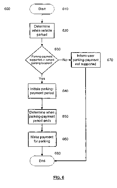
Figure 6 illustrates a method 600 according to an embodiment of the present
invention which begins in step 610. In step 620 a navigation device 200, such
as that
illustrated in Figure 2, determines when a vehicle carrying the navigation
device 200
parks. In some embodiments, the navigation device 200 automatically determines
the
5 parking of the vehicle, whilst in other embodiments the navigation device
200 receives
an input from the user indicating that they have parked. Embodiments of
methods for
determining the parking of the vehicle will be explained in detail later. In
step 630 it is
determined whether parking-payment is supported in a current parking location.
That is,
whether the location at which the vehicle carrying the navigation device 200
allows
10 payment for parking to be made by embodiments of the present invention. If
parking-
payment is supported, then in step 640 a parking-payment period is initiated
and in step
650 it is determined when the parking-payment period ends. The parking-payment
period is the period for which payment is to be made for parking i.e. the
period for which
the vehicle is parked. Embodiments of methods for performing steps 630-650
will be
15 described in detail later. In step 660 a payment for the parking period is
made and the
method ends in step 680. However, if in step 630 it had been determined that
parking-
payment by embodiments of the present was not supported at the parking
location, the
user is informed in step 670 and the method proceeds to step 680.
Figure 7 illustrates a system 700 of an embodiment of the invention. The
system
700 comprises a navigation device 710, such as that illustrated in more detail
in Figure
2, and a server 720, such as that illustrated in more detail in Figure 3. The
navigation
device 710 and server 720 are in wireless communication via a data
communications
channel 730 which can be implemented by a number of different arrangements,
either
directly or indirectly via another device such as a mobile telecommunications
device e.g.
mobile phone. The navigation device 710 is carried by a vehicle which is not
shown in
Figure 7 for clarity. However, as a result of being carried by the vehicle,
the navigation
device 710 is moved into a parking area 740, as indicated by arrow 750, where
the
vehicle is parked for a parking-period or parking duration, as will be
explained. The
server 720 stores, or has access to, a storage device storing user information
related to
a user of the navigation device. The user information comprises information
identifying
the user e.g. name etc., information identifying the vehicle carrying the
navigation device
710 and payment information identifying a method of payment for parking
services by
the user of the navigation device 710. The method of payment may be credit or
debit
card details for the user, the user may hold a pre-paid account with the
server 720
containing credits for parking payment, or the user may receive a periodic eg
monthly
invoice for parking services which requires later payment. In cases where the
navigation
CA 02725988 2010-11-25
WO 2010/081563 PCT/EP2009/058824
16
device 710 is used by a plurality of users and/or in a plurality of vehicles,
it is envisaged
that user and/or vehicle profiles may be established which allow the user of
the
navigation device 710 to select a corresponding user profile from a plurality
of user
profiles e.g. "Steven", "Chris", "Mary"... and/or a vehicle profile from a
plurality of vehicle
profiles e.g. "Car 1", "Car 2".... In the case of selecting a user profile the
payment
information may be linked to that user profile, such that each user may have a
corresponding payment method. In some cases, the payment method may be unique
to
each user, but it is also envisaged that a plurality of users may share a
single payment
method e.g. company or joint credit card. The one or more vehicle profiles may
comprise a make and model of the vehicle, registration information of the
vehicle and/or
a colour of the vehicle. Such information may be required to be supplied to a
computer
system (not shown) of a parking area 740 operator, thereby enabling the
parking area
operator to identify vehicles having paid for parking.
As noted above, in step 620 the parking-payment module 490 executing on the
navigation device 710 determines when the vehicle carrying the navigation
device 710
parks. In some embodiments, this may be achieved by receiving an input from
the user
indicating that they have parked the vehicle. For example, a "parking" button
may be
provided on the navigation device 710 for activation by the user to indicate
parking of the
vehicle. In other embodiments, a graphical item may be displayed on the
display device
240 of the navigation device 710 for receiving a user input to indicate
parking of the
vehicle. Such a graphical item may only be displayed when the navigation
device 710
determines that the vehicle is stationary i.e. that a current location of the
vehicle is not
changing or has not changed for a predetermined period of time e.g. 10
seconds.
However, in other embodiments of the invention, the parking-payment module 490
may
automatically determine that the vehicle has parked. The parking-payment
module 490
may automatically determine that the vehicle has parked in one embodiment by
determining that the current location of the vehicle has ceased to change, or
has not
changed for a predetermined period of time e.g. 10 seconds. However, in order
to avoid
incorrectly determining that the vehicle has parked e.g. when temporarily
stopped whilst
driving, the parking-payment module 490 may compare the location at which the
vehicle
has stopped with map data or with information indicating the location of one
or more
parking areas previously communicated to the device as will be explained
later, to
determine that the vehicle has stopped in a parking area, or at least an area
which is not
part of the road system. Alternatively or additionally, the parking-payment
module 490
may receive information relating to the status of the vehicle and sub-systems
thereof
which may be used to determine parking of the vehicle. The navigation device
710 may
CA 02725988 2010-11-25
WO 2010/081563 PCT/EP2009/058824
17
be communicatively coupled to the vehicle e.g. via a local wireless network,
such as
Bluetooth, or via a wired connection, such as CAN bus of the vehicle, to
receive
information indicating the status of the vehicle and the sub-systems thereof.
Parking of
the vehicle may be determined from information indicating one or more of: the
vehicle's
electrical system is powered or shut down, keys have been removed from an
ignition of
the vehicle, one or more doors of the vehicle have been opened or an engine of
the
vehicle has been stopped. A determination of the vehicle's electrical system
being
powered down may also be made from a power supply to the navigation device
from the
vehicle. Furthermore, in some embodiments, parking of the vehicle may also be
made
or supplemented by an indication of the navigation device being removed from
the
docking arm 292. Advantageously, by determining parking from the vehicle's
status,
more accurate and rapid parking determinations may be made. In another
alternative
embodiment, the navigation device 710 may receive a wireless signal indicating
that it is
proximal to, or within, a parking area, such as a signal transmitted by a
transmitter in the
parking area 740.
Once the parking-payment module 490 has determined that the vehicle has
parked, a determination is made whether the current parking location supports
parking-
payment according to embodiments of the present invention. In some embodiments
of
the present invention, the determination is made by the navigation device 710.
However,
in other embodiments the determination is made by the server 720 and
information
indicative of the determination communicated to the navigation device 710 via
the
communications channel 730.
Firstly embodiments in which the navigation device 710 determines that the
vehicle is parked in a parking location supporting parking-payment will be
explained. In
some embodiments, the navigation 710 may have received information from the
server
720 identifying one or more parking areas, as will be explained in further
detail below. In
this case, the navigation device 710 may compare the current parking location
i.e.
location of the navigation device 710 against the location of the one or more
parking
areas previously received from the server 720 to determine that the vehicle is
parked in
a parking location supporting parking-payment. However, in another embodiment,
the
navigation device 710 may compare the current parking location against map
data which
indicates one or more parking areas supporting parking payment according to
embodiments of the invention to determine that the vehicle is parked in a
parking
location supporting parking-payment.
In other embodiments, the server 720 determines that the vehicle is parked in
a
parking location supporting parking-payment, based upon information received
from the
CA 02725988 2010-11-25
WO 2010/081563 PCT/EP2009/058824
18
navigation device 710. Referring to Figure 8, method steps are shown which may
be
performed in embodiments of step 630 shown in Figure 6. The method begins in
step
810 and in step 820 information is received by the server 720 indicating a
geographical
location at which the vehicle containing the navigation device 710 has parked.
The
geographical location may be indicated by coordinates in a predetermined
coordinate
system, such as longitude and latitude. In step 830 the geographical location
of the
navigation device 710 is compared against a store of locations supporting
parking-
payment. In some embodiments, the store may be a database of parking areas 740
supporting parking-payment according to embodiments of the invention. The
result of
the determination is communicated to the navigation device 710 from the sever
720 via
the communications channel 730 in step 840. The result may be a binary
indication and
may be communicated in a parking-payment supported message. The message may,
in
some embodiments, communicate further information to the navigation device 710
regarding the parking area 740, such as cost information e.g. information
indicating a
cost per unit time for parking in that parking area and/or temporal
information regarding
a payment-period or maximum stay duration in the parking area. For example,
the
information may indicate that payment is made for each whole hour and/or that
the
maximum parking duration is, for example, two hours.
As a result of the determination process, the navigation device 710 may be
arranged to display an indication on the display 240 of whether parking-
payment is
supported in the current location. The display device 240 may display a
message
informing the user that parking payment is not supported and advising them
that other
payment means must be used, or may display a message indicating that parking
payment is supported at the current location. The message displayed on the
display
device 240 may further comprise information related to the parking area 740,
such as
the cost per unit time obtained from local storage or the server 720.
If parking-payment is supported in the parking location, the navigation device
710
may either require user input confirming that the user wishes to park in the
current
location e.g. accepting the cost per unit hour, or the navigation device 710
may
automatically inform the server 720 that the parking period should begin, as
in step 640
shown in Figure 6. The navigation device 710 may send a message to the server
720
indicating that the parking-period should begin i.e. that a payment will be
made for the
vehicle's parking from the time of the message. Advantageously, receipt of the
message
by the server 720 allows information indicating that the vehicle will be
paying for parking
to be communicated from the server 720 to a computer system of the parking
area
provider i.e. car park owner or operator so that parking enforcement of the
parking area
CA 02725988 2010-11-25
WO 2010/081563 PCT/EP2009/058824
19
740 may be informed. Furthermore, the message also allows the server 720 to
determine the time at which parking begins for payment calculation.
The parking-payment period ends, in step 650 shown in Figure 6, in response to
the navigation device 710 sending a further message to the server 720. In some
embodiments, the parking-payment module 490 of the navigation device 710
automatically determines that the parking-payment period should end based upon
a
location of the vehicle. However, in other embodiments the user provides an
input to the
navigation device 710 indicating that the parking-payment period should end.
The parking-payment module 490 may determine that the vehicle has ceased to
be parked based upon the location of the navigation device 710. Once the
location of
the navigation device 710 changes, the parking payment module 710 may
determine
that the vehicle is not parked. In some embodiments, the parking payment
module 490
may determine that the vehicle is not parked once the location changes more
than a
predetermined distance e.g. 50m. In other embodiments, once the parking-
payment
module 490 has initiated the parking-payment period, an indication that the
navigation
device 710 is in a "parked" mode may be displayed on the display device 240.
The
displayed indication may comprise a control allowing the user to end the
parking-
payment period e.g. a graphical button or the like. In some embodiments,
activation of
the control causes the parking-payment module 490 to end the parking-payment
period.
However, in other embodiments, the parking-payment module may only determine
the
end of the parking payment period once the location of the navigation device
710
changes by more than a predetermined amount following the receipt of the user
input.
Advantageously, this prevents a user from fraudulently ending the parking-
payment
period without leaving the parking area 740. Also in step 650 the navigation
device 710
may display a summary of the parking-payment period e.g. information
indicating the
length of the parking payment period and/or a cost of the parking-payment
period.
In step 660 the server 720 makes a payment for the parking utilising the
payment
information held by the server 720. For example, the server 720 may charge the
user's
credit or debit car, or may debit the user's account held with the server 720.
The server
720 may send confirmation to the navigation device 710 that the payment has
been
successful and information indicating the successful payment may be displayed
on the
display device 240 of the navigation device 710.
As noted above, in some embodiments of the invention, the user may be directed
to a suitable parking area by the navigation device 710. Exemplary embodiments
of the
invention will now be explained with reference firstly to Figure 9. A method
900 of
providing route guidance to a parking area 740 according to an embodiment of
the
CA 02725988 2010-11-25
WO 2010/081563 PCT/EP2009/058824
invention will now be explained. The method 900 begins in step 910. In step
920 a
current location of a navigation device 710 is determined, such as the
location of the
navigation device 710 in Figure 7. The location of the navigation device 710
may be
determined from received GPS signals. Based upon the determined location, in
step
5 930 one or more corresponding parking areas 740 are determined. The parking
areas
740 determined in step 730 may be, in some embodiments, a predetermined number
of
parking areas. However, in other embodiments, the parking areas 740 may be
those
parking areas within a predetermined distance of the location of the
navigation device
710. For example, the parking areas determined in step 930 may be those within
1, 2 or
10 5km of the location of the navigation device 710. It will be realised that
other distances
may be considered. The distance may be selected according to an environment
surrounding the navigation device 710. For example, if the current location of
the
navigation device 710 is determined to be in an urban environment, where there
would
be expected to be numerous parking areas, then the distance considered may be
15 reduced to limit the determined number of parking areas. However if the
environment is
rural, where parking areas would be expected to be less numerous, then the
distance
may be correspondingly increased. In step 940 a parking area is selected. If,
in step
930, only a single parking area had been determined e.g. only one parking area
is within
the determined distance, then that parking area may be automatically selected
in step
20 940. However, if a plurality of parking areas have been determined in step
830 then a
selection of one parking area is made from amongst those parking areas. The
parking
area may be automatically selected in step 940 according to one or more
predetermined
criteria. For example, a nearest parking area may be selected or a cheapest
(lowest
cost) parking area may be selected if cost information for the determined
parking areas
is known. Other criteria may be used as appropriate. The criteria may be
stored as part
of the current user and/or vehicle profile. For example, the user Chris" may
prefer a
nearest parking area, whilst the user "Mary" may prefer the cheapest parking
area.
Furthermore, vehicle criteria may affect the selection e.g. Carl may include
height
information indicating that the vehicle is a large or tall vehicle, according
to which a
selection of an appropriate parking area may be made. In other embodiments,
information identifying the plurality of parking areas determined in step 930
is displayed
on the display 240 and a user input is received by the navigation device 710
to select
one of the displayed parking areas. Once a parking area 740 has been selected,
in step
950 route guidance from the current location of the navigation device 710 is
provided to
direct the user to the selected parking area. The method ends in step 960.
The above-described method may be performed by a navigation device 710 with
CA 02725988 2010-11-25
WO 2010/081563 PCT/EP2009/058824
21
reference to stored parking area information which identifies a plurality of
parking areas.
In some embodiments the parking information is stored on a store directly
accessible to
the navigation device 710, such as memory 230. The parking area information
may
form part of the map data. However, as will be explained with reference to
Figure 10, in
other embodiments the method may be performed in conjunction with a server,
such as
server 720 shown in Figure 7.
Referring to Figure 10, a method 1100 for providing route guidance to a
parking
area 740 is shown which begins in step 1010. In step 1020 a current location
of a
navigation device, such as navigation device 710 shown in Figure 7, is
determined, for
example with reference to received GPS signals. In step 1030 location
information
identifying the location of the navigation device 710 is communicated from the
navigation
device 710 to a server, such as server 720 shown in Figure 7, via
communications
channel 730. The location information may identify the location of the
navigation device
710 in a predetermined coordinate system, such as longitude and latitude. In
step 1040
one or more suitable parking areas are determined by the server 720 according
to the
received location information. The parking areas 740 determined in step 1040
may be,
in some embodiments, a predetermined number of parking areas. However, in
other
embodiments, the parking areas may be those parking areas within a
predetermined
distance of the location of the navigation device 710. For example, the
parking areas
determined in step 1040 may be those within 1, 2 or 5km of the location of the
navigation
device 710. It will be realised that other distances may be considered. The
distance
may be selected according to an environment surrounding the navigation device
710.
For example, if the current location of the navigation device 710 is
determined to be in
an urban environment, where there would be expected to be numerous parking
areas,
then the distance considered may be reduced to limit the determined number of
parking
areas. However if the environment is rural, where parking areas would be
expected to
be less numerous, then the distance may be correspondingly increased. In step
1050
information identifying the one or more suitable parking areas determined in
step 1040 is
communicated to the navigation device 710 via the communications channel 730.
The
communicated information may identify the locations of the one or more
determined
parking areas. In some embodiments, the information communicated to the
navigation
device 710 includes information relating to other aspects of the determined
parking
areas. The additional information may include price information, for example
indicating a
cost per unit time for parking in each parking area, opening time information
indicating
opening hours of each parking area if the parking area is not 24hr; maximum
stay
information indicating a maximum stay duration of the parking area; and other
restriction
CA 02725988 2010-11-25
WO 2010/081563 PCT/EP2009/058824
22
information, for example relating to a maximum size of vehicles allowed to
park each
parking area. It will be realised that not all information is communicated for
every
parking area e.g. some information may be communicated for some parking areas,
whilst other information is communicated for one or more other parking areas.
In step
1060 one of the communicated parking areas is selected. The parking area may
be
automatically selected in step 1060 by the navigation device 710, e.g. by the
parking-
payment module 490, according to one or more predetermined criteria. For
example, a
nearest parking area may be selected or a cheapest (lowest cost) parking area
may be
selected if cost information for the determined parking areas is known. Other
criteria
may be used as appropriate. The criteria may be stored as part of the current
user
and/or vehicle profile. For example, the user Chris" may prefer a nearest
parking area,
whilst the user "Mary" may prefer the cheapest parking area. Furthermore,
vehicle
criteria may affect the selection e.g. Carl may include height information
indicating that
the vehicle is a large or tall vehicle, according to which a selection of an
appropriate
parking area may be made. In other embodiments, information identifying the
plurality of
parking areas communicated to the navigation device in step 1050 is displayed
on the
display 240 and a user input is received by the navigation device 710 to
select one of the
displayed parking areas. Once a parking area has been selected, in step 1070
route
guidance from the current location of the navigation device 710 is provided to
direct the
user to the selected parking area. The method ends in step 1080.
In other embodiments, the method 1000 described with reference to Figure 10
may be altered. For example, in step 1040 the server 720 may automatically
select a
parking area for which route guidance is to be provided. The server 720 may
automatically select a parking area for which route guidance is to be provided
by the
navigation device 710 based upon the same criteria as the navigation device
710 in the
embodiment described with reference to Figure 10. In order to facilitate the
selection by
the server 710, the navigation device 710 may communicate relevant
information, such
as user-specified criteria e.g. information indicating that a nearest parking
location is to
be selected, to the server 720 in step 1030 in conjunction with the
information indicating
the location of the navigation device 710. Once selected by the server 720,
information
indicating the location of the parking area for which route guidance is to be
provided is
communicated to the navigation device 710 in step 1050 and step 1060 is
omitted.
Referring to Figure 11, an embodiment of a method 1100 of alerting a user to
expiry of a parking-payment period by a portable navigation device will now be
explained. As noted above, in some embodiments, temporal information relating
to the
parking area may be communicated to the navigation device 710 by the server
720. The
CA 02725988 2010-11-25
WO 2010/081563 PCT/EP2009/058824
23
method 1100 explained with reference to Figure 11 alerts a user of the
portable
navigation device to expiry of one or more temporal periods related to the
parking area.
In some embodiments, the one or more alerts are based on a location of the
portable
navigation device in relation to the location of the parking area in which the
user's
vehicle is parked. The method 1100 begins in step 1110. In step 1120 temporal
information is received from the server 720. As described above, the temporal
information may be received in step 840 of the method 800 described with
reference to
Figure 8. The temporal information relates to a parking area and may indicate
the
payment-period or maximum stay duration in the parking area. For example, the
information may indicate that payment is made for each whole hour and/or that
the
maximum parking duration is, for example, two hours. In step 1130 the
navigation
device determines a time at which it will check its current location for
issuing a parking
alert to the user. The time at which the navigation device checks its current
location is
determined with reference to the received temporal information. In some
embodiments,
the alert is determined according to maximum stay information indicating the
maximum
parking duration in the parking area received by the navigation device 710. In
one
embodiment, the check is performed after 50% of the maximum stay duration has
elapsed, although it will be realised that other durations or times may be
selected as
appropriate. In step 1140, the navigation device determines its current
location at the
time determined in step 1130. The current location of the navigation device
710 may be
determined from received GPS signals. Based on the location determined in step
1140,
in step 1150 one or more parking alert times are determined in step 1160. The
parking
alert times are times at which an alert should be provided to the user
regarding the
received temporal duration of the parking area and the current location of the
navigation
device. In one embodiment, if more than a predetermined amount of the
remaining time
e.g. 80% is required for the user to return to the parking area, based upon an
estimated
travelling speed and map data accessible by the navigation device 710, then
the
navigation device issues an alert to the user indicating that they should
begin to return to
the parking area. The alert may be in the form of an audible and/or visual
output of the
portable navigation device 710. However, if the distance between the current
location of
the navigation device 710 and the parking area is such that the user may
travel to the
parking area in less than the predetermined amount of the remaining time, then
a further
location-check time is determined at which the navigation device 710 checks
its current
location.
It will be apparent from the foregoing that the teachings of the present
invention
provide an arrangement whereby payment for parking is facilitated. In
embodiments of
CA 02725988 2010-11-25
WO 2010/081563 PCT/EP2009/058824
24
the invention payment may be made automatically. In some embodiments of the
invention payment for parking is simplified by use of a navigation device to
accurately
measure a parking duration.
It will also be appreciated that whilst various aspects and embodiments of the
present invention have heretofore been described, the scope of the present
invention is
not limited to the particular arrangements set out herein and instead extends
to
encompass all arrangements, and modifications and alterations thereto, which
fall within
the scope of the appended claims.
For example, whilst embodiments described in the foregoing detailed
description
refer to GPS, it should be noted that the navigation device may utilise any
kind of
position sensing technology as an alternative to (or indeed in addition to)
GPS. For
example the navigation device may utilise using other global navigation
satellite systems
such as the European Galileo system. Equally, it is not limited to satellite
based but
could readily function using ground based beacons or any other kind of system
that
enables the device to determine its geographic location.
It will also be well understood by persons of ordinary skill in the art that
whilst the
preferred embodiment implements certain functionality by means of software,
that
functionality could equally be implemented solely in hardware (for example by
means of
one or more ASICs (application specific integrated circuit)) or indeed by a
mix of
hardware and software. As such, the scope of the present invention should not
be
interpreted as being limited only to being implemented in software.
Lastly, it should also be noted that whilst the accompanying claims set out
particular combinations of features described herein, the scope of the present
invention
is not limited to the particular combinations hereafter claimed, but instead
extends to
encompass any combination of features or embodiments herein disclosed
irrespective of
whether or not that particular combination has been specifically enumerated in
the
accompanying claims at this time.