Note: Descriptions are shown in the official language in which they were submitted.
CA 02726562 2010-12-29
AUTOMATIC ORIGIN DETERMINATION FOR FASTER ROUTE REQUEST INITIATION
AND RESULTING SYSTEM RESPONSE TIME
BACKGROUND
Technical Field:
[0001] The following relates generally to location based services (LBS) for
mobile devices,
and in particular to systems and methods for providing navigation information,
such as routes,
ETA information, search functionality, and other related functionality on
mobile devices.
Related Art:
[0002] Rush hour traffic volume, road construction, vehicular collisions,
and roadside
emergencies are just a few examples of the various events and circumstances
that can cause
traffic congestion. Due to the nature of such events traffic congestion can be
difficult to predict.
Although radio, television, and online news sources can provide traffic
information gathered
using various techniques such as highway cameras, phone-in traffic tips,
satellite imagery, and
road sensors; this information is stale and/or inaccurate.
[0003] Old or inaccurate traffic information can be troublesome for various
reasons. For
example, an alternate traffic route, which may be less convenient, is chosen
due to a traffic report
indicating that a traffic problem exists, which problem has since been
alleviated. This can cause
a commuter to take a less optimal route, which can waste fuel, cause them to
be late, and cause
congestion on side-roads. Conversely, a traffic report may indicate that the
commuter's route is
clear, when in fact an event has, in the meantime, created a traffic jam,
since the traffic report is
based on information that is not current.
[0004] Navigation systems typically rely on using Geographic Positioning
System (GPS)
fixes, in order to determine a present location, from which information such a
route to a
destination can be provided. However, determining a position based on received
GPS signals
takes time, and such time often depends on how many GPS satellite signals can
be received, and
the quality of such reception. Other approaches have included attempting to
use triangulation
based on reception of multiple cell tower identifiers and signal strength
information for such cell
towers. Although such approaches can produce an estimated position of the
mobile device, they
- 1 -
CA 02726562 2010-12-29
can be inaccurate, in that signal strength measurements can vary widely based
on current
= topological and environmental conditions. Also, it may be more difficult
in practice to obtain a
number of identifiers for cell towers, in order to perform a triangulation.
Using a single cell
= tower identifier may fail to provide sufficient accuracy, because a cell
tower can serve a wide
area, in some cases, such that simply connecting to that cell tower would be
insufficiently precise
for navigation purposes.
[0005] Therefore, advances in location determination and responsive
of such location
determination remain desirable, even though GPS location determination is used
for the most
part.
BRIEF DESCRIPTION OF THE DRAWINGS
[0006] Embodiments will now be described by way of example, and not
limitation, with
reference to the appended drawings wherein:
[0007] Figure 1 depicts a schematic diagram illustrating an example
of a traffic notification
system providing a traffic notification to one mobile device according to data
obtained from a
plurality of other mobile devices.
[00081 Figure 2 depicts a system diagram illustrating the
environment in which data items
are pushed from a host system to a mobile device.
[0009] Figure 3 depicts a schematic diagram of a mobile device and a
display screen
therefor.
[0010] Figure 4 depicts a schematic diagram of another mobile device
and a display screen
therefor.
[0011] Figure 5 depicts a block diagram of an exemplary embodiment
of a mobile device.
[0012] Figure 6 depicts a block diagram of an exemplary embodiment
of a communication
subsystem component of the mobile device of Figure 5.
[0013] Figure 7 depicts a screen shot of an exemplary home screen
displayed by a mobile
device.
[0014] Figure 8 depicts a block diagram illustrating exemplary ones
of the other software
applications and components shown in Figure 5.
- 2 -
CA 02726562 2010-12-29
[0015] Figure 9 depicts a method for sending ETA information to
contacts.
= [0016] Figure 10 depicts an example start screen of a navigation
function that can provide
functionality and use technology described above.
[0017] Figure 11 depicts an example display of ETA information.
[0018] Figure 12 depicts an example user interface element that can
be provided with the
method of Figure 10.
[0019] Figure 13 depicts a user interface element within the
navigation application.
[0020] Figure 14 depicts a first example user interface element
relating to route
representation.
[0021] Figure 15 depicts an example method for maintaining and/or
producing a list of cell
tower identifiers with which the mobile device has communicated, and a GPS fix
for the mobile
device during such communication.
[0022] Figure 16 depicts an example method of accessing such a list
to obtain a location to
be used as a location of the mobile device, prior to or in the absence of a
current GPS fix.
DETAILED DESCRIPTION
[0023] It will be appreciated that for simplicity and clarity of
illustration, where considered
appropriate, reference numerals may be repeated among the figures to indicate
corresponding or
analogous elements. In addition, numerous specific details are set forth in
order to provide a
thorough understanding of the embodiments described herein. However, it will
be understood by
those of ordinary skill in the art that the embodiments described herein may
be practiced without
these specific details. In other instances, well-known methods, procedures and
components have
not been described in detail so as not to obscure the embodiments described
herein. Also, the
description is not to be considered as limiting the scope of the embodiments
described herein.
[0024] Mobile devices often have GPS receivers (or more generically,
a satellite positioning
system signal receiver, such as GPS, GloNASS, etc.) for determining a current
location of a
device, which can be used in a variety of ways and applications, such as for
navigation (GPS will
be used generically for all such satellite navigation systems, for
simplicity). Obtaining a GPS
takes time, and sometimes a GPS fix is not available. For example, a person
leaving work may
- 3 -
CA 02726562 2010-12-29
leave a cubicle, and walk some distance before being exposed to strong enough
signals from
enough satellites to obtain a GPS fix. It is recognized herein, however, that
a number of useful
outputs relating to navigation can be provided in the absence of a precise GPS
fix. In one
example, if a user of a navigation application is leaving work, the user does
not necessarily need
precise information about how to navigate from an office location to a nearby
freeway, since the
user typically would be familiar with the vicinity. However, the user would be
concerned with a
larger context, such as how long a drive time may be required to get home, and
whether any
abnormal traffic conditions indicate that a detour or an alternate route
should be taken. Such
information can be often provided without a current GPS fix, if a general
location is known. One
approach to providing a general location is to determine identifying
information for a cell phone
tower that the mobile device current can communicate with. A correlation is
maintained
between such identifying information and prior GPS fixes for the mobile
device. Such
correlation can be maintained in a background process, for example, as a user
simply uses the
mobile device and/or the navigation application. The identifying information
current obtained is
used to determine whether a GPS fix is correlated with that cell phone tower.
If so, then the
prior GPS fix is used as an estimate of a current location of the mobile
device until a current fix
is available.
By particular example, when a user first begins using a navigation application
(e.g., selects the
application to begin execution through an interface on the mobile device), the
identifying
information for the cell phone tower would be available before the GPS fix
(even assuming that a
GPS fix can be obtained), and a GPS fix identified as associated with the cell
phone tower can be
used as a current position estimate. The current position estimate can in turn
be used as an origin
to a destination. Other information, such as traffic congestion information,
can be requested
sooner, as well. Navigation outputs, such as an estimated time of arrival and
a recommended
route can be provided based on the current position estimate. For normal user
behaviour, the
availability of such information is expected to be immediately useful, in
order for a user to
determine what to do, and where to go, comparatively more so than information
such as turn-by-
turn directions.
- 4 -
CA 02726562 2010-12-29
= I. Route Representation: Technology for representation of routes can be
used in
navigation supports navigation applications and other applications.
= [0025] An object for vehicle navigation is providing a route from
an origin to a destination.
The route can be roughly defined to include an ordered sequence of roadways
that may be
traveled to move from the origin to the destination. In general, there will be
many (perhaps
millions of) possible sequences that may be used to travel between any given
origin/destination
pair. In practice, there are a relatively small number that are "good" (as
defined by some
measure or measures, such as shortest, fastest, and more subjective measures
such as simplest,
least stress, most scenic, and so on). Given a set of conditions, there often
can be determined an
optimal (best) route to fit a given measure or measures.
[0026] For computer-assisted vehicle navigation, a route can be
defined relative to a map
database. A map database generally comprises an object-based encoding of the
geometry,
connectivity and descriptive attributes of a collection of roadways, and is
usually based on a
topological model, such as a 1D directed graph inscribed within a 2D surface
sheet. The
individual objects in a model of this type include edges that mostly represent
roads (such as the
centerlines of roads), and nodes that represent locations where roads
intersect and cul-de-sacs
terminate. A "road" or "roadway" (used interchangeably here) in a map database
can be defined
in terms of a connected "chain" of edges that share a common name. Most
roadways consist of a
single connected chain. Some roads are more complicated, for instance, a road
may be split in
two by another geographic feature such as a river.
[0027] Certain non-road features can also be represented by edges,
including railroads,
streams and rivers, and the boundaries of area objects (faces) such as parks,
water bodies, and
military bases, as well as boundaries of towns, cities, counties and similar
divisions of
governmental hierarchy.
[0028] The geometry of the database can be represented by coordinate
locations (x/y or
longitude/latitude points) associated with nodes, and "shape" (often point
sequences) associated
with edges. The "raw" connectivity of the roadways is represented by the
edge/node
connectivity that is provided by the directed graph representation: each edge
has a specific
"from" and "to" node; each node has a list of edges that have the node at
either the "from" or
"to" end.
-5 -
CA 02726562 2010-12-29
[0029] Actual road connectivity may be limited by descriptive attributes
such as turn
prohibitions and travel mode restrictions. Other descriptive attributes can
include the road name,
legal travel speed and direction (bi-directional or one-way), number of lanes
and similar.
[0030] Map databases can carry different levels of detail. A fully-
detailed, or large-scale
map database will include everything from the most important long-distance
highways to minor
back alleys and un-paved country lanes. A sparsely detailed, or small-scale
map database can
have only the most important highways and connections that allow long distance
travel.
[0031] Map databases also include varying geographical extents of coverage.
Some map
databases may cover only a small area. Others may cover entire continents.
Often there is an
inverse correlation between scale and coverage extent, in that large-scale
maps tend to have
limited geographic coverage, while continental extent maps may have limited
detail. Such a
circumstance was particularly true for paper maps (city map vs. road atlas),
and is still true in
paper-equivalent computer map renderings. A familiar example is the internet-
based mapping
service: when zooming in on a given displayed map area, more detail and less
extent are
displayed, and when zooming out, less detail and more extent are displayed.
[0032] In fully detailed databases, wide roads and roads with wide medians
may also be split
lengthwise into two separate one-way chains representing the two independent
directions of
travel. Many roads are short, consisting of only a single edge. Some roads are
very long,
spanning from ocean to ocean across a continent, and consisting of thousands
of individual edges
within a full-detailed representation. Most roads are somewhere between these
two extremes.
[0033] A route as originally described may therefore be represented as a
specific sequence of
connected edges within a map database. Given a route with this representation,
a variety of
properties about the overall route can be determined by inspecting the
individual edges. For
instance, to determine the length of the route, one can sum the lengths of the
individual edges.
Similarly, to estimate travel time of a route, one can determine the travel
time for each edge
(length divided by speed) and accumulate the sum over the whole set. Such a
travel time is
termed "static", in that it would be based on a fixed representation of speed.
[0034] More elaborate results may be determined by examining a route's edge
sequence
within the context of the containing database. For instance, the list of turn-
by-turn instructions
that are required to follow a route may be inferred by examining how the route
traverses each
- 6 -
CA 02726562 2010-12-29
node relative to the other edges that occur at the corresponding intersection.
Some intersection
traversals are more important than others, and may warrant explicit
identification in a route
representation. Other intersections are more trivial; for example, those in
which no turn is made.
Such intersections may not be explicitly identified in some representations.
II. Traffic and Congestion technology can be used for modeling of traffic
patterns and
= congestion, and can build on technology for route representation and
support
various applications, such those described herein.
[0035] Turning now to Figure 1, an example zone of traffic is shown,
which comprises a
traffic "problem" hereinafter named a congested zone 2. The congested zone 2
comprises a
"left-bound" lane of traffic 4 (i.e. with respect to the page) and a "right-
bound" lane of traffic 6.
It can be seen that the congested zone 2 represents a common zone of traffic
congestion caused
by any one or more traffic events. Another zone of traffic is also shown in
Figure 1 and, in this
example, represents an upstream zone 8, which refers to any roadway that is,
approaching,
expected to connect, lead into, or is simply an upstream portion of a same
roadway that includes
the congested zone 2. In this example, the upstream zone 8 thus feeds traffic
into the congested
zone 2 such that at least one mobile device 100 approaching the congested zone
2 can be
determined.
[0036] In the example shown in Figure 1, the congested zone 2 at a
particular point in time
comprises three vehicles travelling left-bound 4, namely vehicles 10B, 10C,
and 10D; and
comprises a single vehicle 10E travelling right-bound 6. For the present
discussion, the
congestion occurs in the left-bound lane only whereas vehicle 10E is moving at
a normal rate of
speed in the right-bound lane. The upstream zone 8, at the same point in time,
comprises a
single vehicle 10A travelling left-bound 4 towards the congested zone 2. Each
vehicle 10A-10E
comprises a respective data communications device, hereinafter referred to as
a mobile device
100A-100E, which travels with the corresponding vehicle 10A-10E in which it
currently resides.
As will be explained below, the mobile device 100 can be any suitable device
capable of
communicating via a wireless network 200. The mobile devices 100 utilize such
capability to
provide device data 78 to a dynamic traffic notification sub-system 80, via
the wireless network
200. The device data 78 comprises information related to the location and
speed of the vehicle
10, as measured by, or obtained by or from another source, the mobile device
10 located and
travelling within the vehicle 10. For example, mobile device 100B in vehicle
10B may utilize a
- 7 -
CA 02726562 2010-12-29
GPS function to measure the speed of the vehicle 10B and the current location,
prepare device
data 78, and send the device data 78 to the dynamic traffic notification sub-
system 80,
hereinafter referred to as "the notification sub-system 80" for brevity.
[0037] As will also be explained below, the notification sub-system 80 uses
device data 78
from a plurality of mobile devices 100 to dynamically determine traffic
conditions, such as the
development of the congested zone 2, in order to prepare a notification 84
that can be sent to a
mobile device 100 that is expected to be headed towards the congested zone 2.
III. Building and Using a Traffic Congestion Model.
[0038] Commute traffic congestion tends to follow very reliable patterns.
For example, a
given stretch of heavily used freeway at 7:30 AM every weekday morning, would
be expected to
have traffic moving much slower than during normal "free-flow" conditions.
Within that basic
model, more refined patterns can be found. For example, it can be found that
traffic may be
heaviest on Monday (33 mph average), a little lighter Tuesday-Thursday (37
mph) and perhaps
lighter still on Friday (45 mph). However, the same stretch of freeway may be
free flowing (e.g.,
65 mph) at noon, flowing well during the evening commute (e.g., 60 mph), and
racing along at
75+ mph overnight and on the weekend.
[0039] Further, observations for a single person traveling at the roughly
the same time over
the same route for five days a week, 50 weeks a year, can be accumulated to
develop a robust
model of the traffic congestion that this person faces each day, including its
consistency, its day-
of-the-week and season-of-the-year variability, and perhaps most importantly,
the congestion's
effect on the travel time that the person experiences daily.
[0040] Furthermore, these observations can yield information about how the
congestion
tends to affect certain portions of the route. For example, a portion of a
route following "Hwy 1"
tends to flow at 39 mph, and the portion that follows "Hwy 2" tends to flow at
51 mph. In turn,
the portion of Hwy 1 between 7th and 10th streets can be observed to average
34 mph at around
7:44 AM, and the portion between 10th and 14th streets observed to average 41
mph at 7:51 AM
and so on.
[0041] This description of a single person's experience can be generalized
into the system
concept of collecting traffic data using "traffic probe" and using that data
for traffic modeling.
By collecting observations or data for a large enough number of
vehicles/drivers (by, for
- 8 -
CA 02726562 2013-08-07
example, using wireless devices with GPS), then those observations and that
data can be
aggregated and collectively analyzed to develop an overall model of traffic
congestion. In such a
system, each device (e.g., owned by a driver of a vehicle) serves as a probe
sensing the traffic
conditions at particular locations and times. The overall picture serves as
the traffic model, and
is a byproduct of the system.
(a) Real Time Traffic Data.
[0042] Previously, it was disclosed that data collection for and
observations about personal
driving habits can be used to improve accuracy of the estimation of route
travel time and
correspondingly ETA determination, and further that historical traffic models
have the potential
for even greater improvement and wider application.
[0043] However, both of these methods rely on the stability of previously
observed driving
patterns, and some times actual traffic congestion (due to accidents, bad
weather, sporting events
and similar, or just wide variability) is much worse (and occasionally much
better) than
expected.
[0044] If the departure time for a trip is immediate, it typically is
preferable to know what
the "live, real time" traffic conditions are now, rather than relying solely
on the historical model,
at least for the first portion of the route. Such an approach should yield
more accurate travel
time and ETA, and can serve as a trigger to alert the driver that today's
experience will be worse
("you're going to be late") or better ("you have ten extra minutes") than
usual.
[0045] With a network of probes (which can be used to produce the
historical traffic model
described previously), it is possible to monitor the current activity of all
probes in real time to
produce a current picture of traffic congestion, as will be addressed further
below. For example
for all traffic segments, a list of recent probe samples for each segment can
be tracked and used
to compute a "live expected speed" for the segment.
[0046] An approach to using these live speeds to compute travel time can be
similar to the
use of speeds from the historical model and can include stepping through the
route's edges in
sequence computing travel times for each edge. If the edge corresponds to a
traffic segment for
which there is a current live speed then that speed can be used. If this is no
live speed, then the
historical model value from the appropriate time slot can be used. If there is
no traffic segment,
then a static speed can be used.
- 9 -
CA 02726562 2010-12-29
[0047] In practice, a robust implementation is more complicated than this
conceptual
description. One reason is that live traffic has a limited "shelf life". In
other words, after some
amount of time (e.g., 30 minutes), it is likely that the current live speed
will be invalid, and that
the historical pattern speed may be more accurate.
[0048] A preferred speed determination function includes a continuous
function of live and
historical values. A simplified description of one such function can be: for a
set time along the
route (<10 minutes) the average live speed of recent probes is used, then for
some period of time
(10 ¨ 30 minutes) a decreasing fraction of live combined with an increasing
fraction of historical
speed is used, after which historical is used exclusively.
[0049] Because conditions will change, the ETA calculation preferably is
continuously
updated as the route is consumed (traveled) during driving. Such preference is
based on at least
three reasons. First, actual traffic congestion will continue to evolve, and
probes driving
somewhere up ahead may detect different and new conditions, thus evolving the
live model.
Second, because part of the route has been consumed by driving, the location
framework for live
traffic has shifted, so that live information is needed for roads that are
further along the route
than originally needed. Third, because actual travel progress may vary greatly
from the original
estimate (particularly on long routes), the time framework of the historical
model may also
change, resulting in a dramatic increase or decrease of likely traffic speeds
far ahead.
[0050] Live traffic and congestion data, such as that obtained from in-
vehicle probes, can be
used for modelling traffic and congestion, and can supplement a historical
model. A mixture of
live data and historical data can be used.
(b) Estimating Required Time of Departure.
[0051] In addition to giving ETA estimates, understanding travel times a
second application
that relates to ETA. This application can be phrased as "What is my Required
Time of Departure
(a.k.a ETD)?" In other words, if I know that I need to get somewhere at time
T, when do I need
to leave in order to be confident that I will make it? An example method to
determine includes:
perform a "static" travel time summation (ttstat,c); assume the departure time
is T - ttstatic and
calculate the ETAI; if ETA' > T, then back up the departure time by the
difference (ETA] ¨ T)
and try again. Repeat until ETA, <= T. Error factors may be used "pad" the
travel time
-10-
CA 02726562 2010-12-29
estimation in order to reduce the chance of being late in case the traffic
happens to a little worse
(but not unusually worse) than usual.
IV. Example Architectures
[0052] To aid the reader in understanding at least one environment in which
the notification
sub-system 80, and the above-described applications, may be implemented, an
example system
comprising the wireless network 200 and other components that may be used to
effect
communications between mobile devices 100 and the notification sub-system 80
will now be
described.
[0053] As noted above, data communication devices will be commonly referred
to as
"mobile devices." Examples of applicable mobile devices include pagers,
cellular phones,
cellular smart-phones, portable gaming and entertainment devices, wireless
organizers, personal
digital assistants, computers, laptops, handheld wireless communication
devices, wirelessly
enabled notebook computers and the like.
[0054] One exemplary mobile device is a two-way communication device with
advanced
data communication capabilities including the capability to communicate with
other mobile
devices or computer systems through a network of transceiver stations. The
mobile device may
also have the capability to allow voice communication. Depending on the
functionality provided
by the mobile device, it may be referred to as a smartphone, a data messaging
device, a two-way
pager, a cellular telephone with data messaging capabilities, a wireless
Internet appliance, or a
data communication device (with or without telephony capabilities).
[0055] The mobile device may be one that is used in a system that is
configured for
continuously routing content, such as pushed content, from a host system to
the mobile device.
An example architecture of such a system will now be described.
(a) Example System Architecture.
[0056] Referring now to Figure 2, an example system diagram showing the
redirection of
user data items (such as message A or C) from a corporate enterprise computer
system (host
system) 250 to the user's mobile device 100 via a wireless router 26 is
provided. The wireless
router 26 provides the wireless connectivity functionality as it acts to both
abstract most of the
wireless network's 200 complexities, and it also implements features necessary
to support
-11-
CA 02726562 2013-08-07
pushing data to the mobile device 100. Although not shown, a plurality of
mobile devices may
access data from the host system 250. In this example, message A in Figure 2
represents an
internal message sent from, e.g. a desktop computer within the host system
250, to any number
of server computers in the corporate network (e.g. LAN), which may, in
general, include a
database server, a calendar server, an E-mail server or a voice-mail server.
[0057] Message C in Figure 2 represents an external message from a sender
that is not
directly connected to the host system 250, such as the user's mobile device
100, some other user's
mobile device (not shown), or any user connected to the public or private
network 224 (e.g. the
Internet). Message C could be e-mail, voice-mail, calendar information,
database updates, web-
page updates or could even represent a command message from the user's mobile
device 100 to
the host system 250. The host system 250 may comprise, along with the typical
communication
links, hardware and software associated with a corporate enterprise computer
network system,
one or more wireless mobility agents, a TCP/IP connection, a collection of
datastores (for
example a data store for e-mail can be an off-the-shelf mail server program
such as Microsoft
Exchange Server or Lotus Notes Server), which typically are behind a
corporate firewall.
[0058] The mobile device 100 may be adapted for communication within
wireless network
200 via wireless links, as required by each wireless network 200 being used.
As an illustrative
example of the operation for a wireless router 26 shown in Figure 2, consider
a data item A,
repackaged in outer envelope B (the packaged data item A now referred to as
"data item (A)")
and sent to the mobile device 100 from an Application Service Provider (ASP)
in the host system
250. Within the ASP is a computer program, similar to a wireless mobility
agent, running on any
computer in the ASP's environment that is sending requested data items from a
data store to a
mobile device 100. The mobile-destined data item (A) is routed through the
network 224, and
through a firewall protecting the wireless router 26.
[0059] Although the above describes the host system 250 as being used
within a corporate
enterprise network environment, this is just one embodiment of one type of
host service that
offers push-based messages for a handheld wireless device that is capable of
notifying and
preferably presenting the data to the user in real-time at the mobile device
when data arrives at
the host system.
- 12 -
CA 02726562 2010-12-29
(i) Message Router/Relay Server.
[0060] Provision of a wireless router 26 (sometimes referred to as a
"relay"), there are a
number of advantages to both the host system 250 and the wireless network 200.
The host
system 250 in general runs a host service that is considered to be any
computer program that is
running on one or more computer systems. The host service is said to be
running on a host
= system 250, and one host system 250 can support any number of host
services. A host service
may or may not be aware of the fact that information is being channelled to
mobile devices 100.
For example an e-mail or message program 138 (see Figure 5) might be receiving
and processing
e-mail while an associated program (e.g. an e-mail wireless mobility agent) is
also monitoring
the mailbox for the user and forwarding or pushing the same e-mail to a
wireless device 100. A
host service might also be modified to prepare and exchange information with
mobile devices
100 via the wireless router 26, like customer relationship management
software. In a third
example, there might be a common access to a range of host services. For
example a mobility
agent might offer a Wireless Access Protocol (WAP) connection to several
databases.
[0061] As discussed above, a mobile device 100 may be a hand-held
two-way wireless
paging computer as exemplified in Figures 3-8, a wirelessly enabled palm-top
computer, a
mobile telephone with data messaging capabilities, a PDA with mobile phone
capabilities, a
wirelessly enabled laptop computer, a vending machine with an associated OEM
radio modem, a
wirelessly-enabled heart-monitoring system or, alternatively, it could be
other types of mobile
data communication devices capable of sending and receiving messages via a
network
connection, e.g. a portable gaming device. Although the system is exemplified
as operating in a
two-way communications mode, certain aspects of the system could be used in a
"one and one-
half' or acknowledgment paging environment, or even with a one-way paging
system. In such
limited data messaging environments, the wireless router 26 still could
abstract the mobile device
100 and wireless network 200, offer push services to standard web-based server
systems and
allow a host service in a host system 250 to reach the mobile device 100 in
many countries.
[0062] The host system 250 shown herein has many methods when
establishing a
communication link to the wireless router 26. For one skilled in the art of
data communications
the host system 250 could use connection protocols like TCP/IP, X.25, Frame
Relay, ISDN,
ATM or many other protocols to establish a point-to-point connection. Over
this connection
there are several tunnelling methods available to package and send the data,
some of these
- 13 -
CA 02726562 2010-12-29
include: HTTP/HTML, HTTP/XML, HTTP/Proprietary, FTP, SMTP or some other
proprietary
data exchange protocol. The type of host systems 250 that might employ the
wireless router 26
to perform push could include: field service applications, e-mail services,
stock quote services,
banking services, stock trading services, field sales applications,
advertising messages and many
=
others.
[0063] This wireless network 200 abstraction can be accomplished by
wireless router 26,
which can implement this routing and push functionality. The type of user-
selected data items
being exchanged by the host could include: E-mail messages, calendar events,
meeting
notifications, address entries, journal entries, personal alerts, alarms,
warnings, stock quotes,
news bulletins, bank account transactions, field service updates, stock
trades, heart-monitoring
information, vending machine stock levels, meter reading data, GPS data, etc.,
but could,
alternatively, include any other type of message that is transmitted to the
host system 250, or that
the host system 250 acquires through the use of intelligent agents, such as
data that is received
after the host system 250 initiates a search of a database or a website or a
bulletin board.
[0064] The wireless router 26 provides a range of services to make creating
a push-based
host service possible. These networks may comprise: (1) the Code Division
Multiple Access
(CDMA) network, (2) the Groupe Special Mobile or the Global System for Mobile
Communications (GSM) and the General Packet Radio Service (GPRS), and (3) the
upcoming
third-generation (3G) and fourth generation (4G) networks like EDGE, UMTS and
HSDPA,
LTE, Wi-Max etc. Some older examples of data-centric networks include, but are
not limited to:
(1) the Mobitex Radio Network ("Mobitex") and (2) the DataTAC Radio Network
("DataTAC").
[0065] Providing push services for host systems 250 can be bettered by the
wireless router 26
implementing a set of defined functions. The wireless router 26 can be
realized by many
hardware configurations; however, features described likely would be present
in these different
realizations.
[0066] Referring to Figures 3 and 4, one example of a mobile device 100a is
shown in Figure
3, and another example of a mobile device 100b is shown in Figure 4. More
generally, the
numeral "100" will hereinafter refer to any mobile device 100, and by
explanation and reference,
the examples 100a and 100b of Figures 3 and 4. A similar numbering convention
is used for
-14-
CA 02726562 2010-12-29
some other general features common between Figures 3 and 4 such as a display
12, a positioning
device 14, a cancel or escape button 16, a camera button 17, and a menu or
option button 24.
[0067] The mobile device 100a shown in Figure 3 comprises a display 12a and
the cursor or
view positioning device 14 shown in this embodiment is a trackball 14a.
Positioning device 14
may serve as another input member and is both rotational to provide selection
inputs to the main
processor 102 (see Figure 5) and can also be pressed in a direction generally
toward housing to
provide another selection input to the processor 102. Trackball 14a permits
multi-directional
positioning of the selection cursor 18 (see Figure 7) such that the selection
cursor 18 can be
moved in an upward direction, in a downward direction and, if desired and/or
permitted, in any
diagonal direction. The trackball 14a is in this example situated on the front
face of a housing
for mobile device 100a as shown in Figure 3 to enable a user to manoeuvre the
trackball 14a
while holding the mobile device 100a in one hand. The trackball 14a may serve
as another input
member (in addition to a directional or positioning member) to provide
selection inputs to the
processor 102 and can preferably be pressed in a direction towards the housing
of the mobile
device 100b to provide such a selection input.
[0068] The display 12 may include a selection cursor 18 that depicts
generally where the
next input or selection will be received,. The selection cursor 18 may
comprise a box, alteration
of an icon or any combination of features that enable the user to identify the
currently chosen
icon or item. The mobile device 100a in Figure 3 also comprises a programmable
convenience
button 15 to activate a selected application such as, for example, a calendar
or calculator.
Further, mobile device 100a includes an escape or cancel button 16a, a camera
button 17a, a
menu or option button 24a and a keyboard 20. The camera button 17 is able to
activate photo-
capturing functions when pressed preferably in the direction towards the
housing. The menu or
option button 24 loads a menu or list of options on display 12a when pressed.
In this example,
the escape or cancel button 16a, the menu option button 24a, and keyboard 20
are disposed on
the front face of the mobile device housing, while the convenience button 15
and camera button
17a are disposed at the side of the housing. This button placement enables a
user to operate
these buttons while holding the mobile device 100 in one hand. The keyboard 20
is, in this
embodiment, a standard QWERTY keyboard.
- 15 -
CA 02726562 2010-12-29
[0069] The mobile device 100b shown in Figure 4 comprises a display
12b and the
= positioning device 14 in this embodiment is a trackball 14b. The mobile
device 100b also
comprises a menu or option button 24b, a cancel or escape button 16b, and a
camera button 17b.
The mobile device 100b as illustrated in Figure 4, comprises a reduced QWERTY
keyboard 22.
In this embodiment, the keyboard 22, positioning device 14b, escape button 16b
and menu
button 24b are disposed on a front face of a mobile device housing. The
reduced QWERTY
keyboard 22 comprises a plurality of multi-functional keys and corresponding
indicia including
keys associated with alphabetic characters corresponding to a QWERTY array of
letters A to Z
and an overlaid numeric phone key arrangement.
[0070] The mobile device 100 may employ a wide range of one or more
positioning or
cursor/view positioning mechanisms such as a touch pad, a positioning wheel, a
joystick button,
a mouse, a touchscreen, a set of arrow keys, a tablet, an accelerometer (for
sensing orientation
and/or movements of the mobile device 100 etc.), or other input device,
whether presently
known or unknown. Similarly, any variation of keyboard 20, 22 may be used. It
will also be
appreciated that the mobile devices 100 shown in Figures 3 and 4 are for
illustrative purposes
only and various other mobile devices 100 are equally applicable to the
following examples. For
example, other mobile devices 100 may include the trackball 14b, escape button
16b and menu
or option button 24 similar to that shown in Figure 4 only with a full or
standard keyboard of any
type. Other buttons may also be disposed on the mobile device housing such as
color coded
"Answer" and "Ignore" buttons to be used in telephonic communications. In
another example,
the display 12 may itself be touch sensitive thus itself providing an input
mechanism in addition
to display capabilities. Furthermore, the housing for the mobile device 100
should not be limited
to the single-piece configurations shown in Figures 3 and 4, other
configurations such as
clamshell or "flip-phone" configurations are also applicable.
[0071] Now, to aid the reader in understanding the structure of the
mobile device 100 and
how it can communicate with the wireless network 200, reference will now be
made to Figures 5
through 8.
(ii) Example Mobile Device Architecture.
[0072] Referring first to Figure 5, shown therein is a block diagram
of an exemplary
embodiment of a mobile device 100. The mobile device 100 comprises a number of
components
- 16 -
CA 02726562 2010-12-29
such as a main processor 102 that controls the overall operation of the mobile
device 100.
= Communication functions, including data and voice communications, are
performed through a
communication subsystem 104. The communication subsystem 104 receives messages
from and
sends messages to a wireless network 200. In this exemplary embodiment of the
mobile device
=
100, the communication subsystem 104 is configured in accordance with the
Global System for
Mobile Communication (GSM) and General Packet Radio Services (GPRS) standards,
which is
used worldwide. Other communication configurations that are equally applicable
are the 3G and
4G networks such as EDGE, UMTS and HSDPA, LTE, Wi-Max etc. New standards are
still
being defined, but it is believed that they will have similarities to the
network behaviour
described herein, and it will also be understood by persons skilled in the art
that the aspects
disclosed herein can be used with and adapted for other suitable communication
protocols and
standards that may be developed in the future. The wireless link connecting
the communication
subsystem 104 with the wireless network 200 represents one or more different
Radio Frequency
(RF) channels, operating according to defined protocols specified for GSM/GPRS
communications.
[0073] The main processor 102 also interacts with additional
subsystems such as a Random
Access Memory (RAM) 106, a flash memory 108, a display 110, an auxiliary
input/output (110)
subsystem 112, a data port 114, a keyboard 116, a speaker 118, a microphone
120, a GPS
receiver 121, short-range communications 122, and other device subsystems 124.
[0074] Some of the subsystems of the mobile device 100 perform
communication-related
functions, whereas other subsystems may provide "resident" or on-device
functions. By way of
example, the display 110 and the keyboard 116 may be used for both
communication-related
functions, such as entering a text message for transmission over the network
200, and device-
resident functions such as a calculator or task list.
[0075] The mobile device 100 can send and receive communication
signals over the wireless
network 200 after required network registration or activation procedures have
been completed.
Network access is associated with a subscriber or user of the mobile device
100. To identify a
subscriber, the mobile device 100 may use a subscriber module component or
"smart card" 126,
such as a Subscriber Identity Module (SIM), a Removable User Identity Module
(RUIM) and a
Universal Subscriber Identity Module (USIM). In the example shown, a
SIM/RUIM/USIM 126
-17-
CA 02726562 2010-12-29
is to be inserted into a SIM/RUIM/USIM interface 128 in order to communicate
with a network.
Without the component 126, the mobile device 100 is not fully operational for
communication
with the wireless network 200. Once the SIM/RUIM/USIM 126 is inserted into the
= SIM/RUIM/USIM interface 128, it is coupled to the main processor 102.
[0076] The mobile device 100 is a battery-powered device and includes
a battery interface
132 for receiving one or more rechargeable batteries 130. In at least some
embodiments, the
battery 130 can be a smart battery with an embedded microprocessor. The
battery interface 132
is coupled to a regulator (not shown), which assists the battery 130 in
providing power V+ to the
mobile device 100. Although current technology makes use of a battery, future
technologies
such as micro fuel cells may provide the power to the mobile device 100. In
some embodiments,
a plurality of batteries, such as a primary and a secondary batter may be
provided
[0077] The mobile device 100 also includes an operating system 134
and software
components 136 to 146 which are described in more detail below. The operating
system 134 and
the software components 136 to 146 that are executed by the main processor 102
are typically
stored in a persistent store such as the flash memory 108, which may
alternatively be a read-only
memory (ROM) or similar storage element (not shown). Those skilled in the art
will appreciate
that portions of the operating system 134 and the software components 136 to
146, such as
specific device applications, or parts thereof, may be temporarily loaded into
a volatile store such
as the RAM 106. Other software components can also be included, as is well
known to those
skilled in the art.
(A) Mobile Device Software & Firmware.
[0078] The subset of software applications 136 that control basic
device operations,
including data and voice communication applications, maybe installed on the
mobile device 100
during its manufacture. Software applications may include a message
application 138, a device
state module 140, a Personal Information Manager (PfM) 142, a connect module
144 and an IT
policy module 146. A message application 138 can be any suitable software
program that allows
a user of the mobile device 100 to send and receive electronic messages,
wherein messages are
typically stored in the flash memory 108 of the mobile device 100. A device
state module 140
can provide persistence, i.e. the device state module 140 provides for
availability and storage of
potentially important device data. Device state module 140 can be implemented
using flash
- 18 -
CA 02726562 2010-12-29
=
memory 108 (or other non-volatile memory technologies), so that the data is
not lost when the
mobile device 100 is turned off or loses power. A PIM 142 includes
functionality for organizing
and managing data items of interest to the user, such as, but not limited to,
e-mail, text messages,
instant messages, contacts, calendar events, and voice mails, and may interact
with the wireless
network 200. A connect module 144 implements the communication protocols that
are required
for the mobile device 100 to communicate with the wireless infrastructure and
any host system
250, such as an enterprise system, that the mobile device 100 is authorized to
interface with. An
IT policy module 146 can receive IT policy data that encodes IT policies, and
may be
responsible for organizing and securing rules, such as a "Set Maximum Password
Attempts" IT
policy, and password expiration policies.
[0079] Other types of software applications or components 139 can also be
installed on the
mobile device 100. These software applications 139 can be pre-installed
applications (e.g.,
applications other than message application 138) or third party applications,
which are added
after the manufacture of the mobile device 100. Examples of third party
applications include
games, calculators, and utilities.
[0080] The additional applications 139 can be loaded onto the mobile device
100 through at
least one of the wireless network 200, the auxiliary I/0 subsystem 112, the
data port 114, the
short-range communications subsystem 122, or any other suitable device
subsystem 124.
[0081] The data port 114 can be any suitable port that enables data
communication between
the mobile device 100 and another computing device. The data port 114 can be a
serial or a
parallel port. In some instances, the data port 114 can be a USB port that
includes data lines for
data transfer and a supply line that can provide a charging current to charge
the battery 130 of the
mobile device 100.
[0082] For voice communications, received signals are output to the speaker
118, and signals
for transmission are generated by the microphone 120. Although voice or audio
signal output is
accomplished primarily through the speaker 118, the display 110 can also be
used to provide
additional information such as the identity of a calling party, duration of a
voice call, or other
voice call related information.
-19-
CA 02726562 2010-12-29
(B) Wireless Communication Sub-system.
= [0083] Referring now to Figure 6, an exemplary block diagram of
the communication
subsystem component 104 is shown. The communication subsystem 104 includes a
receiver
150, a transmitter 152, and example associated components such as one or more
embedded or
internal antenna elements 154 and 156, Local Oscillators (LOs) 158, and a
processing module
such as a Digital Signal Processor (DSP) 160. The particular design of the
communication
subsystem 104 can be dependent on the communication network 200 with which the
mobile
device 100 is intended to operate. Thus, it should be understood that the
design illustrated in
Figure 6 serves only as one example. Radios also can be implemented
differently, for example,
LOs can be avoided by avoiding intermediate frequencies, such as by using
direct digital
sampling.
[0084] Signals received by the antenna 154 through the wireless
network 200 are input to the
receiver 150, which may perform such common receiver functions as signal
amplification,
frequency down conversion, filtering, channel selection, and analog-to-digital
(A/D) conversion.
AID conversion of a received signal allows more complex communication
functions such as
demodulation and decoding to be performed in the DSP 160. In a similar manner,
signals to be
transmitted are processed, including modulation and encoding, by the DSP 160.
These DSP-
processed signals are input to the transmitter 152 for digital-to-analog (D/A)
conversion,
frequency up conversion, filtering, amplification and transmission over the
wireless network 200
via the antenna 156. The DSP 160 not only processes communication signals, but
also provides
for receiver and transmitter control. For example, the gains applied to
communication signals in
the receiver 150 and the transmitter 152 may be adaptively controlled through
automatic gain
control algorithms implemented in the DSP 160.
[0085] The wireless link between the mobile device 100 and the
wireless network 200 can
contain one or more different channels, typically different RF channels, and
associated protocols
used between the mobile device 100 and the wireless network 200. An RF channel
is a limited
resource that should be conserved, based on concerns such as limits of overall
bandwidth and
limited battery power of the mobile device 100.
[0086] When the mobile device 100 is fully operational, the
transmitter 152 is typically
keyed or turned on only when it is transmitting to the wireless network 200
and is otherwise
- 20 -
CA 02726562 2010-12-29
turned off to conserve resources. Similarly, the receiver 150 may be
periodically turned off to
conserve power until it is needed to receive signals or information (if at
all) during designated
time periods. The receiver 150 also can be turned on to poll for data to be
retrieved.
[0087] Some aspects of the description provided relate to a system
architecture where
information can be pushed to mobile devices. Such system architectures
can,operate to push
information responsive to a request from a mobile. For example, mobile device
100 can request
information periodically, and the system can respond with any messages or
notifications
determined to be applicable to device 100.
(C) Example User Interface.
[0088] Turning now to Figure 7, the mobile device 100 may display a home
screen 40, which
may be the active screen when the mobile device 100 is powered up or may be
accessible from
other screens. The home screen 40 generally comprises a status region 44 and a
theme
background 46, which provides a graphical background for the display 12. The
theme
background 46 displays a series of icons 42 in a predefined arrangement on a
graphical
background. In some themes, the home screen 40 may limit the number icons 42
shown on the
home screen 40 so as to not detract from the theme background 46, particularly
where the
background 46 is chosen for aesthetic reasons. The theme background 46 shown
in Figure 7
provides a grid of icons. It will be appreciated that preferably several
themes are available for
the user to select and that any applicable arrangement may be used. One or
more of the series of
icons 42 is typically a folder 52 that itself is capable of organizing any
number of applications
therewithin.
[0089] The status region 44 in this embodiment comprises a date/time
display 48. The theme
background 46, in addition to a graphical background and the series of icons
42, also comprises a
status bar 50. The status bar 50 can provide information to the user based on
the location of the
selection cursor 18, e.g. by displaying a name for the icon 53 that is
currently highlighted.
[0090] An application, such as a maps program 60 (see also Figure 8) may be
initiated
(opened or viewed) from display 12 by highlighting a corresponding icon 53
using the
positioning device 14 and providing a suitable user input to the mobile device
100. For example,
maps program 60 may be initiated by moving the positioning device 14 such that
the icon 53 is
-21-
CA 02726562 2013-08-07
highlighted by the selection box 18 as shown in Figure 7, and providing a
selection input, e.g. by
pressing the trackball 14b.
[0091] Figure 8 shows an example of how other software applications and
components 139
that may be stored on and used with the mobile device 100 can use the user
interface. Only
examples are shown in Figure 8 and such examples are not to be considered
exhaustive. In this
example, a global positioning system (GPS) application 54, internet browser
56, simple message
service (SMS) 58, maps program 60 and a profiles application 62 are shown to
illustrate the
various features that may be provided by the mobile device 100. The GPS
application 54, in this
example, comprises a traffic module 55, which represents any sub-program, sub-
routine,
function or other set of computer executable instructions for providing device
data 78 to the
notification sub-system 80, when such data 78 is obtained using the GPS
application 54. Also
shown in Figure 8 is the message application 138, which in the following will
be referred to as
an email application 138 for clarity. It will be appreciated that the various
applications may
operate independently or may utilize features of other applications. For
example, the GPS
application 54 may use the maps program 60 for displaying directions to a
user.
V. An Example Approach to User Interfaces for Sending Notifications of ETA Via
Messaging Technologies
[0092] The above description is related to automatically predicting a
destination for
automatic provision of an ETA and related information. Such ETA can be shared
according to
the disclosure relating to the method of Figure 9, and at least one of the
user interfaces depicted
in Figure 11 and Figure 12.
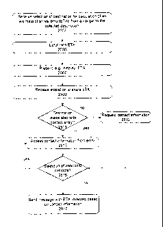
[0093] Turning first to Figure 9, its method is described below. A
selection of destination,
and calculation and display of ETA can be conducted (2503, 2505, 2507), either
by selection of
places, or by automatic selection, as described above. An indication to share
the ETA can be
received (2509). A determination (2511) of whether the destination is
associated with an entry in
a contact manager is made. If there is such an associated entry, then contact
information from
that entry is obtained (2513), and if not then contact information can be
requested (2512) through
the user interface. An option to select additional contacts can be provided
(2515), which can
cause acceptance of additional contacts. Upon determining contact information
to which the
ETA should be sent, messages can be sent (2517), directed to each contact
informational
element. For example, a Short Message Service message can be generated to be
sent to phone
- 22 -
CA 02726562 2013-08-07
numbers associated with the contact entry, and/or phone numbers supplied by a
user through the
interface.
[0094] The user interface element 2805 of Figure 11 depicts an estimated
time of arrival
(ETA) 2820, the distance to travel 2810 and travel time left 2815. The user
interface element
2905 of Figure 12 depicts that a default operating procedure can be that an
SMS message is sent
to a phone number associated with the contact (2910), while a Pick 2915 button
allows the
option to select additional phone numbers. An excuse window 2920 can be
provided, which
allows a reason to be included in the message as to why the ETA may be
different from what
was expected. A send button 2921 allows confirmation of the selections before
the messages
with the ETA information are sent.
[0095] Such aspects can include automatic production/sending of
supplemental/periodic
update notifications based on a variety of conditions or parameters, including
elapsed time,
proximity to POI, departures from the route, or re-selections. For example,
updates can be made
hourly, or when passing a given point. The user interface can be modified or a
user interface
provided that provides user-selectable options, which can have defaults for
such parameters and
conditions.
VI. An Example Approach to User Interfaces and Techniques for Presenting
Traffic
and Route Information in a User-Friendly Format.
[0096] As shown in Figure 14, routes, which can comprise a number of
interconnected road
(travel) segments are depicted (on user interface element 3105) as linear
representations (also
can be called a spine or a trunk), such as linear shape 3110 (which in that it
represents a route,
also can be termed a linear representation of such route). Such linear
representation can be
oriented along one axis of a 2-D display of the device, such as along an axis
that is parallel to a
field of view of a user of the device (and thus can vary if the device is
turned on its side, such
that the route orientation can turn to maintain that orientation with respect
to the viewpoint of the
user). Preferably, the linear representation takes up most of the available
display width.
Indicators of information such as roads to be taken along the route can be
represented at angles
along the linear representation (e.g., indicators 3120a, 3120b, and 3120c).
Indication of traffic
congestion information (3125) can be represented by different cross hatching
or colors within the
area of the linear representation 3110, itself. The user interface element
3105 can also depict the
miles traveled 3150 and the miles to be traveled 3151.
- 23 -
CA 02726562 2013-08-07
[0097] To the extent that these indicators apply to one or more portions of
the route (as
opposed to a point on the route), these indicators also can be viewed as
information segments.
For example indication 3125 of traffic congestion can be termed an information
segment for the
portion of the route on which that congestion occurs, and which is indicated
by indication 3125.
As can be discerned, an information indicator thus can be an indicator of a
point along a route to
which an informational item is relevant, as well as a segment of a route along
which such
informational item is relevant. As will become apparent, such informational
indicators can be
overlayed on the linear representation (linear shape) of the route, as is
3125, above or below such
linear representation.
VII. Automatic Origin Estimation for Navigation Outputs.
[0098] In addition to the aspects disclosed above, aspects herein include
estimating or
predicting an origin for use in generating a navigation output, such as a
recommended route.
[0099] In these aspects, a given mobile device (as disclosed in various
examples above),
tracks which cellular towers it communicates with (such as generally receiving
identifiers for cell
towers that are available in a given area, or more specifically, towers that
are used for data and
voice communication), as the mobile device is used or simply carried about or
otherwise
transported, such as in a car or on foot. Such tracking can include tracking
identifiers of such
cell towers. For each such distinct cell tower identifier, a GPS fix of the
mobile device when the
mobile device is receiving the identifier for that cell tower (or in some more
specific examples,
using or otherwise resident on) that cell tower is obtained and recorded in a
database. In these
aspects, the GPS fix is not a location or attempted to be the location of the
cell tower itself, but a
location of the device when the device uses that cell tower.
[00100] In some aspects, the location recorded for each of the cell towers is
selected based on
knowledge of user/device behaviour. For example, if the mobile device is
traveling a route to a
destination, and upon arriving at the destination, the mobile device is using
a given cell tower, an
identifier for that cell tower can be associated with a GPS fix obtained for
the destination. In a
more concrete example, a mobile device can be used on a route between a user's
home and a
workplace. Upon arriving at the workplace, a cell tower identifier can be
obtained, and a GPS
fix of the workplace can also be obtained. Such an approach is in contrast
with approaches that
- 24 -
CA 02726562 2013-08-07
attempt to make contact with multiple cell towers, and use signal strength
indications from those
cell towers in approximating a current location of the device.
[00101] By way of further explanation, a plurality of mobile devices can be
communicating
with the same cell tower. However, each can be located in a different physical
location, for
which a respective GPS fix is obtained. Then, each mobile device can use its
respective GPS fix
for that same cell tower (when the mobile device is resident on it) as an
origin for navigation.
Thus, these aspects are not attempting to estimate locations of the cell
towers themselves.
Rather, each mobile device independently determines which locations are
important to that
device, for each cell tower, and then can use those pre-determined locations
as likely origins
when resident on each cell tower.
[00102] Figure 15 depicts an example method aspect according to the above-
description.
Figure 15 depicts that a background process running on a mobile device, which
include
obtaining/receiving GPS fixes (3807) as they are available (e.g., from a GPS
receiver, as
disclosed above ¨ See Figure 5). The mobile device identifies a cell tower on
which the mobile
device is resident (3803), or more generally, from which it has received an
identifier. For
example, at any given time, the mobile device may be receiving indicators of a
number of cell
tower identifiers presently within range of the mobile device. Each identifier
is unique to a cell
tower, and each cell tower may belong to or be operated by one or more network
operators,
including operators of networks not usable by the mobile device, itself. Thus,
even if the mobile
device may not actually be using a given cell tower for data or voice
communications, the mobile
device nevertheless may have received one or more identifiers for that cell
tower, and can
associate a GPS fix with that identifier, as it is received.
[00103] In other situations, the only cell tower identifier that may be
available to an
application is an identifier for a cell tower which the device currently would
use for
communication (whether or not the mobile device currently is communicating
with that cell
tower).
[00104] In any of the above examples, the method can monitor whether a given
cell tower
identifier (whether it is one or more than one identifier at any given time)
is new, and perform
the method aspects disclosed below for each such identifier.
- 25 -
CA 02726562 2013-08-07
[00105] If the cell tower (identifier) is new (determination 3820) (which in
some cases can
indicate that a change has been made since a last cell tower identifier was
received), such
determination can be made based on whether the cell tower has an identifier
already stored on
the mobile device. If the identifier does not exist (i.e., the device has not
encountered this tower
before, or it has expired from a cache), then the GPS fix obtained is /stored
(3814) with the
identifier received.
[00106] If
the identifier exists, then the device can perform a variety of actions, or no
action.
The depicted method represents that the GPS fix now being received can be
added to a list of
GPS fixes associated with the cell tower, or used to replace one or more GPS
fixes already
associated with the cell tower (3809). In either case, a further GPS fix can
be obtained (3807) in
due course. If the identifier for the cell tower is unchanged, then the GPS
fix associated with the
still-current cell tower can be updated (3809) based on the obtained GPS fix
(in a case where
multiple cell tower identifiers are currently available or visible, then if
desired, a GPS fix for
each such identifier can be updated). Thus, the method depicted in Figure 15
generally provides
for the last GPS fix while any given cell tower identifier is available is
saved for that cell tower
such that initially, it can be assumed that the mobile device is proximate
that last GPS fix, before
a real GPS fix has been obtained.
[00107] In other embodiments, a weighted average of the GPS fixes can be
maintained, or a
simple average, or several fixes can be maintained for each identifier. For
example, in some
embodiments, multiple GPS fixes may be maintained to be associated with each
cell tower
identifier, and in other embodiments, a blended average of GPS fixes may be
provided. For
example, a blended GPS fix may be produced for multiple cell towers when
concurrently
receiving identifiers for such multiple cell towers. By further example, a
time-weighted average
of locations identified while a given cell tower identifier is received can be
provided. For
example, if the device stops moving for a period of time while communicating
with a given cell
tower identifier, and then starts moving again, the location where the device
was stopped can be
weighted more heavily in a location (generic for a GPS fix, in that the exact
location or GPS fix
that would be associated with the cell tower identifier in this scenario may
never have been
actually determined as a location of the device) associated with that cell
tower identifier.
Further, information about road and point of interest information can be used
in determining a
location associated with a given cell tower identifier. Still further, pre-
defined places (see e.g.,
- 26 -
CA 02726562 2013-08-07
Figure 30 and description relating thereto) can be consulted to determine
whether a GPS fix
obtained while communicating with a given cell tower identifier is proximate
any such pre-
defined place. If there is a pre-defined place close to the current GPS fix,
then that pre-defined
place may be used as a current location of the mobile device when receiving
that cell tower
identifier.
[00108] In some embodiments, a cell tower identifier may be made provided from
an
application programming interface to an application implementing these
disclosed method
aspects. Similarly, a GPS fix may be made available through an application
programming
interface to a GPS function. As such, the application can query each interface
to obtain a current
one or more cell tower identifiers currently being received, and a current
GPS. The application
can schedule such queries, such as on a regular interval. The GPS interface
can be queried
responsive to detecting a change in the cell tower identifier(s) being
received.
[00109] Figure 16 depicts that for the purposes of navigation, input to start
a navigation
function can be received (3907) (e.g., through an interface according to the
example of Figure
10, such as indicating selection of a place 2712 to which to navigate). The
navigation function
can be started in response to a places icon 2712 being selected. The places
icon 2712 can be
selected from among a plurality of icons, e.g., a view icon 2710, a search
icon 2714, and a share
icon 2716. In another example, a device can have a home screen, such as in
Figure 7, where a
number of icons (e.g., icons 42) can be provided, one of which can be an icon
for a navigation
function. Selection of such icon can represent input (3907) and result in
display of the interface
depicted in Figure 10. In some examples, the method aspects of Figure 16
described below can
be initiated after selection from the home screen, even as the Figure 10
interface is being
prepared for display.
[00110] A determination as to whether there is a current GPS fix can be made
(3912), which
can include that a GPS receiver can be turned on to begin a process of
obtaining such a fix
(which would imply an absent of a GPS fix at that instant). If there is a
current GPS fix, then it
can be used (3910) as an origin for producing (3920) a navigation output after
entering/activating
the navigation function (3908).
[00111] If there isn't, then one or more cell tower identifiers currently
available (being
received) by the mobile device (such as by virtue of being resident on that
cell tower, or simply
- 27 -
CA 02726562 2013-08-07
being able to receive an identifier for it) is obtained (3914) (note that
although this statement is
phrased as a conditional, the actual reception of such tower identifiers by
the device as a whole
can be a by-product of using the wireless network, and as such, the reception
of such identifiers
isn't conditional on the absence of a GPS fix, but rather, the method makes
use of the tower
identifiers to access historical GPS fix information, as described below, when
current GPS fix
information is not available.
[00112] The identifier available is looked up (3916) in the data stored on the
computer
readable medium that associates such IDs with GPS fixes, and if there is an
association between
that cell tower identifier and a GPS fix, that associated GPS fix is used
(3918) as an origin for
producing or requesting a navigation output (3920), after entering or
activating (3908) the
navigation function. Such navigation outputs can include a route
determination, an estimated
arrival time, traffic congestion conditions, and the like. If the tower ID is
not found, then the
method can loop determine whether a current GPS fix is available (3912).
[00113] In some exemplary embodiments, the cellular tower IDs and their
associated GPS
fixes are stored in a computer readable medium on the mobile device, such as
in one or more of
flash 108 and RAM 106 of example device 100 in Figure 5. In example
embodiments, a pre-
determined maximum number of cell tower identifier entries can be stored in
the computer
readable medium, such as 1000, more than 1000, or less 1000 identifiers. As
discussed above,
one or more GPS fixes are stored for each identifier, or a location reflecting
an average or a
synthesis of multiple GPS fixes.
[00114] The various examples described above are provided by way of
illustration only
and should not be construed as limiting. The disclosures herein can be adapted
and understood
from that perspective. In addition, separate boxes or illustrated separation
of functional elements
of illustrated systems implies no required physical separation of such
functions, as
communications between such elements can occur by way of messaging, function
calls, shared
memory space, and so on, without any such physical separation. Disclosure of
memories and
other examples of computer readable medium provide for tangible computer
readable media that
store information as specified. Processors can be implemented in a variety of
ways, including
processors that are fully programmable with software, and combinations of
fixed function and
software-programmable processing elements. Different implementations may call
for a different
- 28 -
CA 02726562 2013-08-07
mixture of processing elements, and selection therefrom for a particular
implementation can be
performed by those of ordinary skill in the art.
[00115] Although the above has been described with reference to certain
specific
embodiments, various modifications thereof will be apparent to those skilled
in the art as
outlined in the appended claims. Also, disclosure of certain techniques or
examples with respect
to a subset of the disclosures or examples herein does not imply that such
techniques or examples
pertain only to those disclosures, but rather such selective disclosures are
made for the sake of
clarity, to avoid obscuring principal teachings of the disclosure.
-29 -