Note: Descriptions are shown in the official language in which they were submitted.
CA 02730522 2011-01-11
WO 2009/009822 PCT/AU2008/001021
METHOD AND SYSTEM FOR ENHANCING THE SAFETY OF A REGION
FIELD OF THE INVENTION
The present invention relates to a method and system for enhancing the safety
of a
region.
The invention has been developed primarily for use as a method and system for
enhancing the safety of hazardous regions, such as mining environments, in
which the
terrain, environmental conditions and equipment create areas of high risk and
will be
described hereinafter with reference to this application. However, it will be
appreciated
that the invention is not limited to this particular field of use.
BACKGROUND TO THE INVENTION
Any discussion of the prior art throughout the specification should in no way
be
considered as an admission that such prior art is widely known or forms part
of the
common general knowledge in the field.
Certain regions such as mining environments, including open-cut mines, are
extremely hazardous for those operating equipment within such regions. Open-
cut
mines include narrow and long winding roadways for the transportation of
equipment
and mined material. These roadways generally do not include guard rails and
have a
steep drop-off or cliff-like face on one side.
These roadways are commonly unsealed such that the movement of vehicles such
as haul trucks along these roadways produce large dust clouds which
significantly
reduce the visibility of operators of these trucks and other personnel in that
region,
particularly those following or approaching another vehicle.
CA 02730522 2011-01-11 PCT/AU2008/001021
Received 13 May 2009
[AMENDED PAGE]
-2-
In addition, the geographical location of many mines means they are subject to
severe weather conditions including heavy rainfalls, thick fogs and smoke
which again
reduces the visibility in the region. Furthermore, it is common for work to
take place in
the darkness of night. Consequently, this reduced visibility commonly leads to
accidents many of which result in serious injuries or, in the worst cases,
death. Another
factor contributing to accidents in mining environments is fatigue as
operators are often
required to work long shifts.
Some attempts have been made to reduce the number of accidents in hazardous
environments. However, these systems have not adequately accounted for the
diverse
to characteristics and risk scenarios encountered across a mining environment.
It is an object of the present invention to overcome or ameliorate one or more
of
the disadvantages of the prior art, or to at least provide a useful
alternative.
It is an object of the invention in its preferred form to provide a method and
system for'enhancing the safety of a region in which the relative risk of a
situation is
determined and an alert reflecting this risk is generated.
SUMMARY OF THE INVENTION
According to.a first aspect of the invention, there is provided a method of
enhancing the safety of a region, the method including:
defining a set of modifiable rules for the region;
collecting field data from a plurality of mobile stations movable throughout
the
region, the field data including information relating to the relative movement
of the
mobile stations; and
Amended Sheet
IPEA/AU
CA 02730522 2011-01-11 PCT/AU2008/001021
Received 13 May 2009
[AMENDED PAGE]
-3-
comparing the collected field data to the set of modifiable rules to identify
one or
more areas of potential risk within the region.
Preferably, the method includes modifying at least one rule of the set of
rules to
account for at least one identified area of potential risk. The method may
include
modifying the set of rules to account for each identified area of potential
risk. The
collected field data is preferably analysed using a learning algorithm such
that past data
is taken into account when modifying the set of rules. The learning algorithm
preferably analyses the collected field data to determine whether the
identified areas of
potential risk are caused by a characteristic of the region or due to non-
compliance with
the set of rules.
The region may include a plurality of zones. Preferably, at least one of the
zones
is a base zone. The base zone may include a base station.
Preferably, the set of rules for the region includes zone specific rules. The
set of
rules is preferably stored in a database associated with the base station. The
set of rules
may be uploaded from the base station to a processor of each mobile station
such that
data collected by each mobile station can be compared to the set of rules for
the region
as each mobile station moves throughout the region.
Each mobile station preferably communicates (downloads) the collected field
data
of that mobile station to the database of the base station when that mobile
station is
within the base zone. Preferably, the collected field data is communicated to
the
database by wireless communication. The database may be used to store and
analyse
the collected field data. The learning algorithm is preferably stored in the
database and
used to analyse the collected field data to identify dangerous points and
frequently
occurring risky scenarios within the region or zone. Such dangerous points and
risky
Amended Sheet
IPEA/AU
CA 02730522 2011-01-11
WO 2009/009822 PCT/AU2008/001021
-4-
scenarios may be caused by a characteristic of a particular zone. The set of
rules may
be modified or updated to account for the identified dangerous points and
risky
scenarios.
Preferably, each mobile station includes communication means for
communicating, preferably wirelessly communicating, with the other mobile
stations in
the region such that data can be conveyed throughout the region. Each mobile
station is
preferably continuously in wireless communication with at least one other
mobile
station in the same zone. More preferably, each mobile station is in
continuous
communication with all other mobile stations in the same zone.
The data is preferably conveyed throughout the region via data hops from one
mobile station to another. Preferably, one of the data hops communicates
(transmits and
receives) data from a mobile station in a first zone to at least one mobile
station in a
second zone, the mobile station in the second zone then communicating the data
to at
least one other mobile station in the second zone. By using data hops, any
changes to
the set of rules can be broadcast to all mobile stations within the region,
including those
mobile stations outside the base zone. In addition, data hops may allow each
vehicle to
receive field data from all other vehicles in the region.
The collected field data may be analysed to identify whether or not a mobile
station adhered to the set of rules. The field data collected by a mobile
station may
include at least one of position, velocity and orientation data of that mobile
station and
at least one, preferably all, other mobile stations in its proximity. More
preferably, the
field data includes data of the relative position, velocity and orientation of
other mobile
stations in the same zone as the mobile station which collected that data. The
mobile
CA 02730522 2011-01-11 PCT/AU2008/001021
Received 13 May 2009
[AMENDED PAGE]
-5-
station in one zone may also collect data of the relative position, velocity
and
orientation of mobile stations in other zones.
Each identified area of potential risk preferably has an associated risk
level, each
risk level being determined from the comparison of the collected field data to
the set of
rules for the region. That is, one risk scenario may be deemed to be a high
risk in one
zone and a similar scenario in another zone may be deemed to be a low risk.
Preferably,
the method includes generating an alert which is indicative of the risk level.
It will be
appreciated by those skilled in the art that for certain scenarios which are
identified as
having a low risk level, an alert may not be generated. It will also be
appreciated that
this evaluation of the zone specific risk level, will reduce the occurrence of
false,
misleading and/or unnecessary alerts.
Preferably, each mobile station includes signal generating means for
generating.
the alert. The alert generated by the signal generating means preferably
includes a
visual alert and/or an audio alert. The visual alert may include a symbol. The
symbol
may include a dynamic graphic. The audio alert may include sound and/or a
voice
command.
According to a second aspect of the invention, there is provided a safety
enhancement system including:
a plurality of mobile stations, each mobile station being movable within a
region;
a processor associated with each mobile station for receiving field data
relating to
the relative movement of the mobile stations within the region, each processor
having a
stored set of modifiable rules for the region against which the field data is
compared to
identify one or more areas of potential risk within the region.
Amended Sheet
)PEA/AU
=
CA 02730522 20ii-0i-ii PCT/AU2008/001021
Received 13 May 2009
[AMENDED PAGE]
-6-
According to a third aspect of the invention, there is provided a safety
enhancement system for a region having a plurality of zones, the system
including:
a plurality of mobile stations, each mobile station being movable between the
plurality of zones;
communication means allowing communication of field data between each of the
mobile stations that are in the same zone, the field data relating to the
relative
movement of the mobile stations within the region;
a.processor associated with each mobile station for storing the field data
communicated to that mobile station, each processor having a stored set of
modifiable
rules; and
signal generating means for generating an alert to each mobile station based
on a
comparison of the field data communicated to that mobile station and the set
of
modifiable rules.
Again, the set of rules may be modified as the system learns from the
collected
field data of the risks associated with particular areas of the region or
zone.
Certain embodiments of the method and systems described above may be used in
a mining environment.
BRIEF DESCRIPTION OF THE DRAWINGS'
A preferred embodiment of the invention will now be described, by way of
example only, with reference to the accompanying drawings in which:
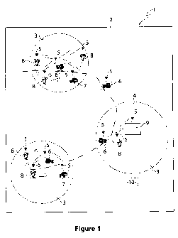
Figure 1 is a diagrammatic view of a region having a plurality of zones in
which a
safety enhancement system according to the invention is implemented;
Figure 2 is a schematic view showing communication lines between mobile
stations within the region;
Amended Sheet
IPEA/AU
CA 02730522 2011-01-11
WO 2009/009822 PCT/AU2008/001021
-7-
Figure 3 is a schematic view illustrating wireless uploading and downloading
of
data between a base station and a mobile station;
Figure 4 is a flow chart of the process of downloading field data;
Figure 5 is a diagrammatic view of a region the field data is used to analyse
an
operator's performance;
Figure 6 is a flow chart showing the process of uploading rules for the region
from a database associated with a base station and onto the mobile stations;
Figure 7 is a schematic view of an operator interface for the mobile station;
Figure 8 is a schematic view of a signal processing box for the mobile
station; and
Figure 9 is an example of a blank showing the layout of the operator
interface.
DETAIL DESCRIPTION OF A PREFERRED EMBODIMENT OF THE INVENTION
Referring to the drawings, the safety enhancement system I is used to enhance
the
safety of a region such as a mine site 2. As shown in Figure 1, the mine site
2 has a
plurality of zones 3 one of which is preferably designated as a base zone 4.
The base
zone is preferably connected to an internal site network. A plurality of
mobile stations
5 are located in or on movable objects in the form of haul trucks 6, utility
vehicles or
other vehicles 7 and personnel 8 which are movable throughout the mine site 2
between
the zones 3. It will be appreciated that the mobile stations 5 may be
associated with
other forms of movable objects as well as fixed objects within the region.
The base zone 4 includes a base station 9 in communication with a database 10
which stores a set of rules for the mine site 2. These rules are established
or defined by
mine management or, as discussed in more detail below, the rules can be
determined
and refined through learning by the system before being approved by mine
CA 02730522 2011-01-11
WO 2009/009822 PCT/AU2008/001021
-8-
management. The rules govern how the operators associated with the various
mobile
stations 5 are to control movement of their vehicle or themselves (in the case
of
personnel) within each zone 3 and between the zones of the mine site 2.
Each mobile station 5 includes a signal processing box 11. The signal
processing
box 11 includes a processor having a memory and communication means. Each
mobile
station 5 includes an operator interface 12 in communication with the signal
processing
box 11. The signal processing box 11 interconnects with sensors and other
associated
sensing equipment of the associated mobile station to determine the position,
velocity
and other various states of that mobile station. The communication means
allows data
from other mobile stations 5 to be detected, collected and stored in the
memory of the
signal processing box 11 of that mobile station such that the relative
proximity to the
other mobile stations can be ascertained. The signal processing box 11 enables
field
data to be transmitted and received, preferably wirelessly, between the mobile
stations 5
as they move throughout the mine site.
The set of rules for the region established by mine management or on the
learning
of the system is uploaded from the database and transmitted from the base
station 9 to
the mobile station 5 when the associated mobile station is in the base zone 4.
The
uploaded set of rules is stored in the processor of the mobile station's
signal processing
box 11.
As each mobile station moves throughout the region, the mobile stations 5
within
the same zone transmit field data relating to their velocity, position and
orientation to
each of the other mobile stations within that zone 3. This data is received
wirelessly via
the communication means by the other mobile stations 5 within that zone 3 and
stored
in the associated processor of that mobile station's signal processing box 11.
CA 02730522 2011-01-11
WO 2009/009822 PCT/AU2008/001021
-9-
The processor compares the collected field data that it has received from the
other
mobile stations 5 within that zone 3 with the uploaded set of rules to
identify one or
more areas of potential risk within the zone.
The operator interface includes a signal generating means 13 having a display
14
and an audio device 15 for producing visual and/or audio alerts to the
operator of the
mobile station 5. These alerts are based on the risk level determined by the
processor
from the comparison of the collected field data and the set of rules for the
region and, in
particular, the rules for that specific zone 3. In the event that the risk
level is
determined to be high, an appropriate alert will be generated by the signal
generating
means 16 such that the operator associated with that mobile station 5 will
become aware
that a high level risk situation is imminent.
For example, if a haul truck 6 is approaching another oncoming haul truck at a
relatively high velocity the risk level may be established as being high.
Similarly, if a
haul truck 6 is travelling through a fog or a dust cloud where there is poor
visibility and
another mobile station 5 has unexpectedly parked due to a breakdown, for
example, the
system is able to alert the operator of the haul truck of the high risk
situation arising
from the parked vehicle. In contrast, if a haul truck 6 is moving through a
car park in
which several haul trucks or other vehicles are parked, the risk level may be
determined
to be low in which case a low level alert may be generated or no alert at all
may be
generated. Continuing with the example of the car park, if the field data
establishes that
there are personnel moving through the car park a high level warning may be
generated
to alert the operator of the haul truck to the fact that these personnel are
in close
proximity and that they should proceed with caution.
CA 02730522 2011-01-11
WO 2009/009822 PCT/AU2008/001021
-10-
Accordingly, it will be appreciated that the set of rules for the region, and
in
particular, the zone specific rules enable the field data to be analysed to
identify the
context in which the data has been generated. That is, for example, in certain
situations
a stationary vehicle in one zone may be a normal situation and may not
generate an
unnecessary alarm that would cause concern to the operator. Likewise, in
another zone
a stationary vehicle may be considered to be a hazard such that an appropriate
alert
signifying the level of risk associated with this area is provided to the
operator. That is,
the system is able to recognise the context of a situation and generate a
signal indicative
of this context.
Upon return to the base zone 4, all data collected by and stored in the
processor of
that mobile station 5 is downloaded via wireless communication to the base
station 9
and stored in the database. This downloaded data is analysed by mine
management
and/or the system for two purposes.
Firstly, mine management is able to use this data to identify whether or not
an
operator of a haul truck, for example, has operated their vehicle in a manner
such that
the rules of the mine site 2 were adhered to. For example, mine management
will be
able to determine whether or not the operator drove at excessive speed,
followed too
closely to the vehicle in front, drove too closely to the edge of the road
and, in
particular, at which locations and the number of instances in which the rules
were not
adhered to.
By monitoring and analysing operator performance, it can be detennined whether
an identified area of potential risk was caused by the characteristics of the
zone in that
area such that the rules should be reviewed and modified to account for these
CA 02730522 2011-01-11
WO 2009/009822 PCT/AU2008/001021
-11-
characteristics of the zone or whether the identified area of risk arose due
to the operator
not adhering to the rules.
Secondly, mine management is able to use the downloaded field data to identify
hotspots or areas of potential risk within the region or a particular zone and
modify one
or more of the rules to account for each identified area of potential risk.
This is
advantageous as many hotspots are not known to mine management when the rules
are
initially set. For example, there may be particular sections of a roadway
which create
blind spots or otherwise require vehicles to slow down. In such situations,
vehicles may
inadvertently get closer to the vehicle in front and thus may not have
sufficient distance
to stop in the event that the leading vehicle suddenly pulls up. The set of
rules will
generally include rules specifying the safe travelling distance between
vehicles.
Accordingly, if the analysis of the collected field data uncovers that at a
certain point or
section of the roadway vehicles routinely travel too closely to the vehicle in
front, mine
management can update the set of rules to account for this area of potential
risk. It will
be appreciated that the learning algorithm may be used to identify an area of
potential
risk which arises due to the characteristics of the zone and automatically
modify the set
of rules.
If the rules are updated when a mobile station 4 is outside the base zone 5, a
data
hop is used to transmit the updated rules from a mobile station in a first
zone to a
mobile station in a second zone until all mobile stations have been updated.
This may
occur as the first mobile station moves from the first zone and enters the
second zone.
Instead, certain mobile stations may be able to communicate with another
mobile station
in another zone. In addition, these data hops also allow each vehicle to
receive field
data from all other vehicles in the region.
CA 02730522 2011-01-11
WO 2009/009822 PCT/AU2008/001021
- 12-
Accordingly, it is an advantage of at least a preferred embodiment of the
safety
enhancement system and method to track the movement of mobile stations within
a
region and use field data in combination with a set of rules to determine the
context of a
potential risk to the mobile station and thus generate warnings that reflect
the actual risk
level.
Although the invention has been described with reference to specific examples,
it
will be appreciated by those skilled in the art that the invention may be
embodied in
many other forms.