Note: Descriptions are shown in the official language in which they were submitted.
CA 02733841 2011-03-10
SYSTEM AND METHOD FOR SIMULATING OILFIELD OPERATIONS
BACKGROUND
Field of the Invention
[0001] Implementations of various techniques described herein generally
relate to
techniques for performing oilfield operations on subterranean formations
having
reservoirs therein, and more particularly, to techniques for simulating
oilfield operations.
Description of the Related Art
[0002] The following descriptions and examples do not constitute an
admission
as prior art by virtue of their inclusion within this section.
[0003] Oilfield operations, such as surveying, drilling, wireline
testing,
completions, production, planning and oilfield analysis, are typically
performed to locate
and gather valuable downhole fluids. Various aspects of the oilfield and its
related
operations are shown in Figures 1A-1D. As shown in Figure 1A, surveys are
often
performed using acquisition methodologies, such as seismic scanners or
surveyors, to
generate maps of underground formations. These formations are often analyzed
to
determine the presence of subterranean assets, such as valuable fluids or
minerals.
This information is used to assess the underground formations and locate the
formations containing the desired subterranean assets. This information may
also be
used to determine whether the formations have characteristics suitable for
storing fluids.
Data collected from the acquisition methodologies may be evaluated and
analyzed to
determine whether such valuable assets are present, and if they are reasonably
accessible.
[0004] As shown in Figures 1B-1D, one or more wellsites may be positioned
along the underground formations to gather valuable fluids from the
subterranean
reservoirs. The wellsites are provided with tools capable of locating and
removing
hydrocarbons, such as oil or gas, from the subterranean reservoirs. As shown
in Figure
1B, drilling tools are typically deployed from the oil and gas rigs and
advanced into the
earth along a path to locate reservoirs containing the valuable downhole
assets. Fluid,
1
CA 02733841 2011-03-10
such as drilling mud or other drilling fluids, is pumped down the wellbore
through the
drilling tool and out the drilling bit. The drilling fluid flows through the
annulus between
the drilling tool and the wellbore and out the surface, carrying away earth
loosened
during drilling. The drilling fluids return the earth to the surface and seal
the wall of the
wellbore to prevent fluid in the surrounding earth from entering the wellbore
and causing
a 'blow out.'
[0005] During the drilling operation, the drilling tool may perform
downhole
measurements to investigate downhole conditions. The drilling tool may be used
to
take core samples of the subsurface formations. In some cases, as shown in
Figure
1C, the drilling tool is removed and a wireline tool is deployed into the
wellbore to
perform additional downhole testing, such as logging or sampling. Steel casing
may be
run into the well to a desired depth and cemented into place along the
wellbore wall.
Drilling may be continued until the desired total depth is reached.
[0006] After the drilling operation is complete, the well may then be
prepared for
production. As shown in Figure 1D, wellbore completions equipment is deployed
into
the wellbore to complete the well in preparation for the production of fluid
through the
wellbore. Fluid is then allowed to flow from downhole reservoirs into the
wellbore and
then the surface. Production facilities are positioned at surface locations to
collect the
hydrocarbons from the wellsite(s). Fluid drawn from the subterranean
reservoir(s)
passes to the production facilities via transport mechanisms, such as tubing.
Various
types of equipment may be positioned about the oilfield to monitor oilfield
parameters, to
manipulate the oilfield operations, and/or to separate and direct fluids from
the wells.
Surface equipment and completion equipment may also be used to inject fluids
into
reservoirs, either for storage or at strategic points to enhance production of
the
reservoir.
[0007] During the oilfield operations, data is typically collected for
analysis and/or
monitoring of the oilfield operations. Such data may include, for example,
subterranean
formation, equipment, historical and/or other data. Data concerning the
subterranean
formation is collected using a variety of sources. Such formation data may be
static or
dynamic. Static data may relate to, for example, formation structure and
geological
2
CA 02733841 2011-03-10
stratigraphy that define geological structures of the subterranean formation.
Dynamic
data may relate to, for example, well production data. Such static and/or
dynamic data
may be collected to learn more about the formations and the valuable assets
contained
therein.
[0008] Sources used to collect static data may be seismic tools, such as
a
seismic truck that sends compression waves into the earth as shown in Figure
1A.
Signals from these waves are processed and interpreted to characterize changes
in the
anisotropic and/or elastic properties, such as velocity and density, of the
geological
formation at various depths. This information may be used to generate basic
structural
maps of the subterranean formation. Other static measurements may be gathered
using downhole measurements, such as core sampling and well logging
techniques.
Core samples are used to take physical specimens of the formation at various
depths
as shown in Figure 1B. Well logging involves deployment of a downhole tool
into the
wellbore to collect various downhole measurements, such as density,
resistivity, etc., at
various depths. Such well logging may be performed using, for example, the
drilling tool
of Figure 1B and/or the wireline tool of Figure 10. Once the well is formed
and
completed, fluid flows to the surface using production tubing and other
completion
equipment as shown in Figure 1D. As fluid passes to the surface, various
dynamic
measurements, such as fluid flow rates, pressure and composition may be
monitored.
These parameters may be used to determine various characteristics of the
subterranean formation.
[0009] Sensors may be positioned about the oilfield to collect data
relating to
various oilfield operations. For example, sensors in the drilling equipment
may monitor
drilling conditions, sensors in the wellbore may monitor fluid composition,
sensors
located along the flow path may monitor flow rates and sensors at the
processing facility
may monitor fluids collected. Other sensors may be provided to monitor
downhole,
surface, equipment or other conditions. Such conditions may relate to the type
of
equipment at the wellsite, the operating setup, formation parameters or other
variables
of the oilfield. The monitored data is often used to make decisions at various
locations
of the oilfield at various times. Data collected by these sensors may be
further analyzed
3
CA 02733841 2011-03-10
and processed. Data may be collected and used for current or future
operations. When
used for future operations at the same or other locations, such data may
sometimes be
referred to as historical data. The data may be used to predict downhole
conditions,
and make decisions concerning oilfield operations. Such decisions may involve
well
planning, well targeting, well completions, operating levels, production rates
and other
operations and/or operating parameters. Often this information is used to
determine
when to drill new wells, re-complete existing wells or alter wellbore
production. Oilfield
conditions, such as geological, geophysical, and reservoir engineering
characteristics,
may have an impact on oilfield operations, such as risk analysis, economic
valuation,
and mechanical considerations for the production of subsurface reservoirs.
Data from
one or more wellbores may be analyzed to plan or predict various outcomes at a
given
wellbore. In some cases, the data from neighboring wellbores, or wellbores
with similar
conditions or equipment, may be used to predict how a well will perform. There
are
usually a large number of variables and large quantities of data to consider
in analyzing
oilfield operations. It is, therefore, often useful to model the behavior of
the oilfield
operation to determine a desired course of action. During the ongoing
operations, the
operating parameters may need adjustment as oilfield conditions change and new
information is received.
[0010] In modeling a reservoir, seismic measurements and measurements at
the
well bore level, both static and dynamic, may be taken. It should be noted
that while
such measurements may be useful in modeling a reservoir, they may not be
sufficient to
fully characterize the subsurface reservoir. Additionally, less data about the
reservoir
may be available at points in the reservoir that are further away from the
wellbores.
Therefore, certain assumptions may be made about these areas, thereby creating
certain degrees of variability in modeling the reservoir.
[0011] As such, various techniques, more fully described below, have been
developed to take into account these assumptions and create multiple
realizations of
the reservoir. To this end, the realizations may be constructed such that each
realization may have approximately the same probability of occurring.
Furthermore,
each realization may be a product of the different combinations of measurement
data
4
CA 02733841 2013-02-01
56866-121
and assumptions used to model the reservoir.
[0012] Techniques have been developed to model various portions of
oilfield
operations such as geological formations, downhole reservoir, wellbores, and
surface
facilities. Examples of these techniques are shown in Patent/Application Nos.
US5992519, W02004049216, W01999/064896, US6313837, US2003/0216897,
US7248259, US2005/0149307 and US2006/0197759. Existing modeling techniques
have typically been used to analyze only specific portions of oilfield
operations. More
recently, attempts have been made to use more than one model in analyzing
certain
oilfield operations. See, for example, Patent/Application Nos. US6980940,
W004049216, US2004/0220846 and US2007/0112547. Additionally, techniques for
modeling certain aspects of an oilfield have been developed, such as
OPENWORKSTM with, e.g., SEISWORKSTM, STRATWORKSTm, GEOPROBETM or
ARIESTM by LANDMARKTm; VOXELGEOTM, GEOLOGTM and STRATIMAGICTm by
PARADIGMTM; JEWELSUITETm by JOATM; RMSTm products by ROXARTM, and
PETRELTm by SCHLUMBERGERTm.
[0013] Typically, for an entire production scenario, multiple
realizations of a
reservoir model may be created to take into account the various assumptions
made
about the reservoir as describe above. Furthermore, multiple surface models
modeling the surface facilities used to extract or otherwise manipulate the
fluids in the
reservoir may also be created. The reservoir models and the surface models may
then be coupled to form a coupled model, and a simulation may then be executed
on
the coupled model. However, current techniques require that each model must be
manually coupled with one another and manually sent to a remote computing
center
to be simulated. In the context of hundreds, and even thousands, of coupled
models,
manually performing these tasks can be very time-intensive and burdensome.
SUMMARY
[0014] Various techniques described herein are directed to a method
for
5
CA 02733841 2013-08-15
50866-121
simulating oilfield operations. In one implementation, the computer
implemented
method may include receiving two or more reservoir models to be simulated and
receiving two or more surface models to be simulated. The method may further
include automatically generating a communication file to couple the two or
more
.
reservoir models with the two or more surface models. Additionally, the method
may include simulating the coupled reservoir models and surface models.
[0015] Various techniques described herein are also directed to a
simulation
system. In one implementation, the simulation system may include at least one
processor and a memory. To this end, the memory may include program
instructions
that may be executed by the processor, thereby causing the processor to
receive two or
more reservoir models to be simulated. Furthermore, the instructions may cause
the
processor to receive two or more surface models to be simulated and
automatically
generate a communication file to couple the reservoir models with the surface
models.
Moreover, the instructions may cause the processor to automatically simulate
the
coupled reservoir models and surface models.
[0016] Various techniques described herein are further directed to a
computer
= readable medium. In one implementation, the computer readable medium may
have
computer executable instructions stored thereon, and -when such instructions
are
executed by a computer, the instructions may cause the computer to receive two
or
more reservoir models to be simulated. The instructions may further cause the
= computer to receive two or more surface models to be simulated and
automatically
generate a communication file to couple the reservoir models with the surface
models.
Additionally, the instructions may cause the computer to automatically
simulate the
coupled reservoir models and surface models.
[0017] The above referenced summary section is provided to introduce
a
selection of concepts in simplified form that are further described below in
the detailed
description section. The summary is not intended to identify key features or
essential
features of the claimed subject matter, nor is it intended to be used to limit
the scope of
the claimed subject matter. Furthermore, the claimed subject matter is not
limited to
implementations that solve any or all disadvantages noted in any part of this
disclosure.
= 6
CA 02733841 2011-03-10
BRIEF DESCRIPTION OF THE DRAWINGS
[0018] The accompanying drawings, described below, illustrate typical
embodiments of the invention and are not to be considered limiting of the
scope of the
invention, for the invention may admit to other equally effective embodiments.
The
figures are not necessarily to scale, and certain features and certain views
of the figures
may be shown exaggerated in scale or in schematic in the interest of clarity
and
conciseness.
[0019] Figure 1A depicts a simplified, schematic view of an oilfield
operation
having subterranean formations containing reservoirs and a survey operation
being
performed by a seismic truck.
[0020] Figure 1B depicts a simplified, schematic view of an oilfield
operation
having subterranean formations containing reservoirs and a drilling operation
being
performed by a drilling tool suspended by a rig and advanced into the
subterranean
formations.
[0021] Figure 1C depicts a simplified, schematic view of an oilfield
operation
having subterranean formations containing reservoirs and a wireline operation
being
performed by a wireline tool suspended in a wellbore by a rig.
[0022] Figure 1D depicts a simplified, schematic view of an oilfield
operation
having subterranean formations containing reservoirs and a production
operation being
performed by a production tool deployed from a production unit into a
completed
wellbore for drawing fluid from the reservoirs into surface facilities.
[0023] Figure 2A depicts a seismic trace of the subterranean formation of
Figure
1A.
[0024] Figure 2B depicts a core test result of the core sample of Figure
1B.
[0025] Figure 2C depicts a well log of the subterranean formation of
Figure 10.
[0026] Figure 2D depicts a production decline curve of fluid flowing
through the
subterranean formation of Figure 1D.
7
CA 02733841 2011-03-10
[0027] Figure 3 is a schematic view, partially in cross-section, of an
oilfield having
a plurality of data acquisition tools positioned at various locations along
the oilfield for
collecting data from the subterranean formation.
[0028] Figure 4 depicts a schematic diagram of a simulation system in
which the
various technologies described herein may be incorporated and practiced.
[0029] Figure 5 depicts a schematic diagram of a coupled model in which
the
various technologies described herein may be incorporated and practiced.
[0030] Figure 6 illustrates a flow diagram of a method for automatically
coupling
reservoir models with surface models in which the various technologies
described
herein may be incorporated and practiced.
DETAILED DESCRIPTION
[0031] The discussion below is directed to certain specific
implementations. It is
to be understood that the discussion below is only for the purpose of enabling
a person
with ordinary skill in the art to make and use any subject matter defined now
or later by
the patent "claims" found in any issued patent herein.
[0032] Various techniques described herein are directed to simulating
oilfield
operations. The following paragraph provides a brief description or summary of
various
techniques described herein.
[0033] In one implementation, a plug-in application may be used to
receive the
location of multiple reservoir models. The plug-in application may then
determine which
reservoir models are to be simulated. Additionally, the plug-in application
may receive
multiple surface models, some of which to be coupled to the reservoir models.
The
plug-in application may then generate a communication file for the surface
models to be
coupled to the reservoir models. The plug-in application may then send the
coupled
models to a computing center to be simulated.
[0034] Various techniques described herein are implemented with reference
to an
oil field operation. As such, before describing implementations of these
techniques, it
may be useful to describe a suitable oil field operation that may benefit from
the various
8
CA 02733841 2011-03-10
techniques described herein.
[0035] Figures 1A-1D depict simplified, representative, schematic views
of an
oilfield 100 having subterranean formation 102 containing reservoir 104
therein and
depicting various oilfield operations being performed on the oilfield. Figure
1A depicts a
survey operation being performed by a survey tool, such as seismic truck 106a,
to
measure properties of the subterranean formation. The survey operation is a
seismic
survey operation for producing sound vibrations. In Figure 1A, one such sound
vibration 112 generated by a source 110 reflects off a plurality of horizons
114 in an
earth formation 116. The sound vibration(s) 112 is (are) received in by
sensors, such as
geophone-receivers 118, situated on the earth's surface, and the geophones 118
produce electrical output signals, referred to as data received 120 in Figure
1A.
[0036] In response to the received sound vibration(s) 112 representative
of
different parameters (such as amplitude and/or frequency) of the sound
vibration(s) 112,
the geophones 118 produce electrical output signals containing data concerning
the
subterranean formation. The data received 120 is provided as input data to a
computer
122a of the seismic truck 106a, and responsive to the input data, the computer
122a
generates a seismic data output 124. The seismic data output may be stored,
transmitted or further processed as desired, for example by data reduction.
[0037] Figure 1B depicts a drilling operation being performed by drilling
tools
106b suspended by a rig 128 and advanced into the subterranean formations 102
to
form a wellbore 136. A mud pit 130 is used to draw drilling mud into the
drilling tools via
flow line 132 for circulating drilling mud through the drilling tools, up the
wellbore 136
and back to the surface. The drilling mud is usually filtered and returned to
the mud pit.
A circulating system may be used for storing, controlling or filtering the
flowing drilling
muds. The drilling tools are advanced into the subterranean formations to
reach
reservoir 104. Each well may target one or more reservoirs. The drilling tools
are
preferably adapted for measuring downhole properties using logging while
drilling tools.
The logging while drilling tool may also be adapted for taking a core sample
133 as
shown, or removed so that a core sample may be taken using another tool.
[0038] A surface unit 134 is used to communicate with the drilling tools
and/or
9
CA 02733841 2011-03-10
offsite operations. The surface unit is capable of communicating with the
drilling tools to
send commands to the drilling tools, and to receive data therefrom. The
surface unit is
preferably provided with computer facilities for receiving, storing,
processing, and/or
analyzing data from the oilfield. The surface unit collects data generated
during the
drilling operation and produces data output 135 which may be stored or
transmitted.
Computer facilities, such as those of the surface unit, may be positioned at
various
locations about the oilfield and/or at remote locations.
[0039] Sensors S, such as gauges, may be positioned about the oilfield to
collect
data relating to various oilfield operations as described previously. As
shown, a sensor
S may be positioned in one or more locations in the drilling tools and/or at
the rig to
measure drilling parameters, such as weight on bit, torque on bit, pressures,
temperatures, flow rates, compositions, rotary speed and/or other parameters
of the
oilfield operation. Sensors may also be positioned in one or more locations in
the
circulating system.
[0040] The data gathered by the sensors may be collected by the surface
unit
and/or other data collection sources for analysis or other processing. The
data
collected by the sensors may be used alone or in combination with other data.
The data
may be collected in one or more databases and/or transmitted on or offsite.
All or select
portions of the data may be selectively used for analyzing and/or predicting
oilfield
operations of the current wellbore and/or other wellbores. The data may be
historical
data, real time data or combinations thereof. The real time data may be used
in real
time, or stored for later use. The data may also be combined with historical
data or
other inputs for further analysis. The data may be stored in separate
databases, or
combined into a single database.
[0041] The collected data may be used to perform analysis, such as
modeling
operations. For example, the seismic data output may be used to perform
geological,
geophysical, and/or reservoir engineering. The reservoir, wellbore, surface
and/or
process data may be used to perform reservoir, wellbore, geological,
geophysical or
other simulations. The data outputs from the oilfield operation may be
generated
directly from the sensors, or after some preprocessing or modeling. These data
outputs
CA 02733841 2011-03-10
may act as inputs for further analysis.
[0042] The data may be collected and stored at the surface unit 134. One
or
more surface units may be located at the oilfield, or connected remotely
thereto. The
surface unit 134 may be a single unit, or a complex network of units used to
perform the
necessary data management functions throughout the oilfield. The surface unit
134
may be a manual or automatic system. The surface unit 134 may be operated
and/or
adjusted by a user.
[0043] The surface unit 134 may be provided with a transceiver 137 to
allow
communications between the surface unit 134 and various portions of the
oilfield or
other locations. The surface unit 134 may also be provided with or
functionally
connected to one or more controllers for actuating mechanisms at the oilfield.
The
surface unit 134 may then send command signals to the oilfield in response to
data
received. The surface unit 134 may receive commands via the transceiver or may
itself
execute commands to the controller. A processor may be provided to analyze the
data
(locally or remotely), make the decisions and/or actuate the controller. In
this manner,
the oilfield may be selectively adjusted based on the data collected. This
technique
may be used to optimize portions of the oilfield operation, such as
controlling drilling,
weight on bit, pump rates or other parameters. These adjustments may be made
automatically based on computer protocol, and/or manually by an operator. In
some
cases, well plans may be adjusted to select optimum operating conditions, or
to avoid
problems.
[0044] Figure 1C depicts a wireline operation being performed by a
wireline tool
106c suspended by the rig 128 and into the wellbore 136 of Figure 1B. The
wireline tool
106c is preferably adapted for deployment into a wellbore for generating well
logs,
performing downhole tests and/or collecting samples. The wireline tool 106c
may be
used to provide another method and apparatus for performing a seismic survey
operation. The wireline tool 106c of Figure 1C may, for example, have an
explosive,
radioactive, electrical, or acoustic energy source 144 that sends and/or
receives
electrical signals to the surrounding subterranean formations 102 and fluids
therein.
[0045] The wireline tool 106c may be operatively connected to, for
example, the
11
CA 02733841 2011-03-10
geophones 118 and the computer 122a of the seismic truck 106a of Figure 1A.
The
wireline tool 106c may also provide data to the surface unit 134. The surface
unit 134
collects data generated during the wireline operation and produces data output
135
which may be stored or transmitted. The wireline tool 106c may be positioned
at various
depths in the wellbore to provide a survey or other information relating to
the
subterranean formation.
[0046] Sensors S, such as gauges, may be positioned about the oilfield to
collect
data relating to various oilfield operations as described previously. As
shown, a sensor
S may be positioned in the wireline tool 106c to measure downhole parameters
which
relate to, for example porosity, permeability, fluid composition and/or other
parameters
of the oilfield operation.
[0047] Figure 1D depicts a production operation being performed by a
production
tool 106d deployed from a production unit or Christmas tree 129 and into the
completed
wellbore 136 of Figure 1C for drawing fluid from the downhole reservoirs into
surface
facilities 142. Fluid flows from reservoir 104 through perforations in the
casing (not
shown) and into the production tool 106d in the wellbore 136 and to the
surface facilities
142 via a gathering network 146.
[0048] Sensors S, such as gauges, may be positioned about the oilfield to
collect
data relating to various oilfield operations as described previously. As
shown, a sensor
S may be positioned in the production tool 106d or associated equipment, such
as the
Christmas tree, gathering network, surface facilities and/or a production
facility, to
measure fluid parameters, such as fluid composition, flow rates, pressures,
temperatures, and/or other parameters of the production operation.
[0049] While only simplified wellsite configurations are shown, it will
be
appreciated that the oilfield may cover a portion of land, sea and/or water
locations that
hosts one or more wellsites. Production may also include injection wells (not
shown) for
added recovery. One or more gathering facilities may be operatively connected
to one
or more of the wellsites for selectively collecting downhole fluids from the
wellsite(s).
[0050] While Figures 1B-1D depict tools used to measure properties of an
oilfield,
12
CA 02733841 2011-03-10
it will be appreciated that the tools may be used in connection with non-
oilfield
operations, such as mines, aquifers, storage or other subterranean facilities.
Also, while
certain data acquisition tools are depicted, it will be appreciated that
various
measurement tools capable of sensing parameters, such as seismic two-way
travel
time, density, resistivity, production rate, etc., of the subterranean
formation and/or its
geological formations may be used. Various sensors S may be located at various
positions along the wellbore and/or the monitoring tools to collect and/or
monitor the
desired data. Other sources of data may also be provided from offsite
locations.
[0051] The oilfield configurations of Figures 1A-1D are intended to
provide a brief
description of an example of an oilfield usable with the present invention.
Part, or all, of
the oilfield may be on land, water and/or sea. Also, while a single oilfield
measured at a
single location is depicted, the present invention may be utilized with any
combination of
one or more oilfields, one or more processing facilities and one or more
wellsites.
[0052] Figures 2A-2D are graphical depictions of examples of data
collected by
the tools of Figures 1A-1D, respectively. Figure 2A depicts a seismic trace
202 of the
subterranean formation of Figure 1A taken by seismic truck 106a. The seismic
trace
may be used to provide data, such as a two-way response over a period of time.
Figure
2B depicts a core sample 133 taken by the drilling tools 106b. The core sample
may be
used to provide data, such as a graph of the density, porosity, permeability
or other
physical property of the core sample over the length of the core. Tests for
density and
viscosity may be performed on the fluids in the core at varying pressures and
temperatures. Figure 2C depicts a well log 204 of the subterranean formation
of Figure
1C taken by the wireline tool 106c. The wireline log 204 may provide a
resistivity or
other measurement of the formation at various depths. Figure 2D depicts a
production
decline curve or graph 206 of fluid flowing through the subterranean formation
of Figure
1D measured at the surface facilities 142. The production decline curve
typically
provides the production rate Q as a function of time t.
[0053] The respective graphs of Figures 2A-2C depict examples of static
measurements that may describe or provide information about the physical
characteristics of the formation and reservoirs contained therein. These
measurements
13
CA 02733841 2011-03-10
may be analyzed to better define the properties of the formation(s) and/or
determine the
accuracy of the measurements and/or for checking for errors. The plots of each
of the
respective measurements may be aligned and scaled for comparison and
verification of
the properties.
[0054] Figure 2D depicts an example of a dynamic measurement of the fluid
properties through the wellbore. As the fluid flows through the wellbore,
measurements
are taken of fluid properties, such as flow rates, pressures, composition,
etc. As
described below, the static and dynamic measurements may be analyzed and used
to
generate models of the subterranean formation to determine characteristics
thereof.
Similar measurements may also be used to measure changes in formation aspects
over
time.
[0055] Figure 3 is a schematic view, partially in cross section of an
oilfield 300
having data acquisition tools 302a, 302b, 302c and 302d positioned at various
locations
along the oilfield for collecting data of the subterranean formation 304. The
data
acquisition tools 302a-d may be the same as data acquisition tools 106a-d of
Figures
1A-D, respectively, or others not depicted. As shown, the data acquisition
tools 302a-d
generate data plots or measurements 308a-d, respectively. These data plots are
depicted along the oilfield to demonstrate the data generated by the various
operations.
[0056] Data plots 308a-c are examples of static data plots that may be
generated
by the data acquisition tools 302a-d, respectively. Static data plot 308a is a
seismic
two-way response time and may be the same as the seismic trace 202 of Figure
2A.
Static plot 308b is core sample data measured from a core sample of the
formation 304,
similar to core sample 133 of Figure 2B. Static data plot 308c is a logging
trace, similar
to the well log 204 of Figure 2C. Production decline curve or graph 308d is a
dynamic
data plot of the fluid flow rate over time, similar to the graph 206 of Figure
2D. Other
data may also be collected, such as historical data, user inputs, economic
information
and/or other measurement data and other parameters of interest.
[0057] The subterranean structure 304 has a plurality of geological
formations
306a-d. As shown, the subterranean structure has several formations or layers,
including a shale layer 306a, a carbonate layer 306b, a shale layer 306c and a
sand
14
CA 02733841 2013-02-01
' 56866-121
layer 306d. A fault 307 extends through the layers 306a, 306b. The static data
acquisition tools are preferably adapted to take measurements and detect
characteristics of the formations.
[0058] While a specific subterranean formation with specific
geological
structures is depicted, it will be appreciated that the oilfield may contain a
variety of
geological structures and/or formations, sometimes having extreme complexity.
In
some locations, typically below the water line, fluid may occupy pore spaces
of the
formations. Each of the measurement devices may be used to measure properties
of
the formations and/or its geological features. While each acquisition tool is
shown as
being in specific locations in the oilfield, it will be appreciated that one
or more types
of measurement may be taken at one or more location across one or more
oilfields or
other locations for comparison and/or analysis.
[0059] The data collected from various sources, such as the data
acquisition
tools of Figure 3, may then be processed and/or evaluated. Typically, seismic
data
displayed in the static data plot 308a from the data acquisition tool 302a may
be used
by a geophysicist to determine characteristics of the subterranean formations
and
features. Core data shown in static plot 308b and/or log data from the well
log 308c
are typically used by a geologist to determine various characteristics of the
subterranean formation. Production data from the graph 308d is typically used
by the
reservoir engineer to determine fluid flow reservoir characteristics. The data
analyzed by the geologist, geophysicist and the reservoir engineer may be
analyzed
using modeling techniques. Examples of modeling techniques are described in
US5992519, W02004049216, W01999/064896, US6313837, US2003/0216897,
US7248259, US20050149307 and US2006/0197759. Systems for performing such
modeling techniques are described, for example, in issued US7248259.
[0060] Figure 4 depicts a schematic diagram of a simulation system
400 in
CA 02733841 2013-02-01
50.866-121
which various technologies described herein may be incorporated and practiced.
The
simulation system 400 may include a local machine 410 with which a user, such
as a
production engineer and/or the like, may interact. Typically, the local
machine 410
may
15a
CA 02733841 2011-03-10
be located remotely from a computing center 460, such as at the desk of the
user or in
an office space. The local machine 410 may also include a simulation
application 420
to create and simulate reservoir models 430 and surface models 440. In one
implementation, the simulation application 420 may be PETRELTm by
SCHLUMBERGERTm and may be used to create reservoir models 430. Typically, the
reservoir models 430 may be simulated in ECLIPSE TM by SCHLUMBERGERTm, and the
surface models 440 may be created in PIPESIM TM by SCHLUMBERGERTm.
[0061] The simulation application 420 may include a plug-in application
450. The
plug-in application 450 may be configured to couple one or more multiple
reservoir
models 430 to one or more multiple surface models 440. Each coupled reservoir
model
430 and surface model 440 may be referred to as a coupled model or a
production
scenario, which is more fully described with reference to Figure 5. The plug-
in
application 450 may send the coupled models to a computing center 460 to be
simulated. In one implementation, the coupled models may be simulated in the
computing center 460 using the AVOCET Integrated Asset Management (IAM)Tm
software environment by SCHLUMBERGERTm.
[0062] The plug-in application 450 may include program instructions for
performing various techniques described herein and will be described in more
detail in
the paragraphs below. The program instructions may be written in a computer
programming language such as C# and the like. The plug-in application 450 may
be
stored in memory, which may be any computer-readable media and may include
volatile, non-volatile, removable, and non-removable media implemented in any
method
or technology for storage of information, such as computer-readable
instructions, data
structures, program modules or other data. Computer storage media may further
include RAM, ROM, erasable programmable read-only memory (EEPROM), flash
memory or other solid state memory technology, CD-ROM, digital versatile disks
(DVD),
or other optical storage, magnetic cassettes, magnetic tape, magnetic disk
storage or
other magnetic storage devices, or any other medium which can be used to store
the
desired information and which can be accessed by the processor. Communication
media may embody computer readable instructions, data structures and program
16
CA 02733841 2011-03-10
modules. By way of example, communication media may include wired media such
as
a wired network or direct-wired connection, and wireless media such as
acoustic, RF,
infrared and other wireless media. Combinations of any of the above may also
be
included within the scope of computer readable media.
[0063] The computing center 460 may be located at/near the oilfield or
remote
from the oilfield. In addition, the computing center may also be remote from
the local
machine 410 and may include a plurality of servers 480 and other computing
resources.
As such, the computing center 460 may have the resources necessary to execute
numerous simulations associated with the reservoir models 430 and surface
models
440. In one implementation, the servers 480 in the computing center 460 may be
configured with a Linux operating system. However, in other embodiments, other
operating systems, such as Windows or Unix-based operating systems may be
used.
Further, the computing center 460 may be in communication with the surface
unit 134,
described in Figures 1B-1D.
[0064] The computing center 460 may be in communication with the local
machine 410 through network 470. The network 470 may be any type of network
including, but not limited to, a wireless network, a local area network (LAN),
or a wide
area network (WAN). Furthermore, the computing center 460 may include multiple
servers 480 and other computing resources to execute the simulations of all
the coupled
models sent by the local machine 410. Once all the coupled models have been
simulated, the computing center 460 may return the results back to the local
machine
410. In one implementation, the results or output of the simulations may be in
the form
of a production forecast. As used herein, a production forecast may represent
an
estimation of the amount of fluid (e.g., oil, gas, water) that can be
recovered from a
reservoir over time according to the parameters set forth by the reservoir
models 430
and surface models 440. As such, the production forecast may be displayed in
the form
of textual information or pictorially, such as in the form of graphs,
histograms, and the
like.
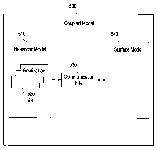
[0065] Figure 5 depicts a schematic diagram of a coupled model 500 in
which the
various technologies described herein may be incorporated and practiced. As
17
CA 02733841 2011-03-10
previously mentioned, the coupled model 500 may in some instances be referred
to as
a production scenario. The coupled model 500 may include a reservoir model 510
in
communication with a surface model 540 through a communication file 530. While
Figure 5 illustrates the coupled model 500 having one reservoir model 510, it
should be
understood that multiple reservoir models are also possible in other
implementations.
[0066] The reservoir model 510 may be used to measure certain aspects of
a
particular reservoir. As such, the reservoir model 510 may model the
interactions of
various fluids within the reservoir such as oil, natural gas, water, and the
like. In one
implementation, the reservoir model 510 may be a file composed of various
uncertainty
variables including, but not limited to, porosity, permeability, pressure, and
temperature.
To this end, the reservoir model 510 may include multiple realizations 520a-n,
each
having different values filled in for the uncertainty variables to account for
different
scenarios in the reservoir. Additionally, the reservoir model 510 may be a
subset of the
reservoir models 430 from Figure 4.
[0067] The surface model 540 may model various surface and/or production
facilities used to measure, access, or otherwise manage the fluids in the
reservoir. For
example, the surface model 540 may account for a particular configuration of
pipelines,
well heads, well bores, etc. Additionally, the surface model 540 may be a
subset of the
surface models 440 from Figure 4.
[0068] The communication file 530 may be generated by the plug-in
application
450 in order to facilitate communication between the reservoir model 510 and
the
surface model 440. As such, the communication file 530 may be configured to
manage
and balance the coupled model 500 by taking into account the restrictions set
forth by
the parameters of the reservoir model 510 and surface model 540. As previously
mentioned, the output of a simulation executed on the coupled model 500 may be
in the
form of a production forecast. The production forecast may estimate the amount
of fluid
recoverable from a reservoir at different points in time i.e., timesteps. To
this end, the
communication file 530 may enable the simulation to account for
characteristics in both
the reservoir model 510 and the surface model 540 at every timestep.
[0069] For instance, different properties in a reservoir, such as the
pressure,
18
CA 02733841 2011-03-10
volume, and temperature of a fluid, may affect the amount of recoverable
fluid. Such
characteristics may be modeled by the reservoir model 510. Moreover, different
surface
network facilities, modeled by the surface model 440, can also affect the
amount of
recoverable fluid. Therefore, the communication file 530 may allow such
properties
from both the reservoir model 510 and the surface model 540 to be taken into
account
in one coupled model 500. For example, the communication file 530 may define
the
type of fluids to be simulated in the coupled model. Additionally, the
communication file
530 may be capable of associating fluids in the reservoir model 510 with
different
elements of the surface model 540, such as pipelines, wellbores, and the like.
As a
result, the entire production process may be simulated as a whole, taking into
account
the realizations 520a-n of the reservoir model 510 coupled with the surface
model 540.
In one implementation, the communication file 530 may be implemented as a
reservoir-
to-surface-link (R2SL) file or an R2SL*.DATA file as part of the AVOCET
Integrated
Asset Management (IAM) software.
[0070]
Figure 6 illustrates a flow diagram of a method for automatically coupling
reservoir models 430 with surface models 440 in accordance with one or more
implementations of various techniques described herein.
[0071]
In step 610, the plug-in application 450 may receive the location of a file
directory containing the reservoir models. For example, the plug-in may prompt
a user
to enter a file path to the file directory having the reservoir models 430.
In one
implementation, the plug-in may be added into a PETRELTm by SCHLUMBERGER
software environment. As such, the file directory with the reservoir models
430 may be
referred to as the PETRELTm simulation folder, and the reservoir models 430
may be
referred to as simulation cases.
[0072]
In step 620, the plug-in application 450 may receive a reservoir model 510
to be coupled to a surface model 540 and simulated. In one implementation, the
reservoir model 510 may be identified by a suffix supplied by the user. The
suffix may
be present in the file name of the reservoir model and may simply be a string
of
characters. As such, the plug-in application 450 may prompt a user to enter a
suffix to
identify the desired reservoir model 510. Other means of identifying a
reservoir model
19
CA 02733841 2011-03-10
510 to be coupled and simulated may also be possible. For example, in a
scenario
using an AVOCET IAM communication file 530, after a user enters the suffix
into the
plug-in application 450, the plug-in application may search for reservoir
models having
"IAM" and the suffix present in their names.
[0073] In step 630, the plug-in application 450 may receive a surface
model 540
that will be used to couple and simulate with a reservoir model. In one
implementation,
the plug-in application 450 may prompt a user to enter the file path to a file
directory
containing the surface model 540. With the correct file path, the plug-in
application 450
may then be able to access the surface model 540 and associate it with the
reservoir
model 510.
[0074] In step 640, a determination may be made as to whether all
reservoir
models to be simulated have been identified. In one implementation, whether
all
reservoir models have been identified may depend on whether a user has
finished
entering all the suffixes associated with the desired reservoir models. Once
the user
has finished, the plug-in application 450 may receive an indication from the
user that all
desired reservoir models 510 have been identified. If not all reservoir models
have been
identified (e.g., the user has not indicated as such), the method 600 may
begin again in
step 620. As such, plug-in application 450 may then continue identifying
another
reservoir model to be simulated based on another suffix inputted by the user.
Then, as
explained previously with reference to step 630, the plug-in application 450
may receive
a surface model to be coupled with the reservoir model. In another
implementation, the
plug-in application may receive two or more reservoir models 510 and two or
more
surface models 540. As such, steps 630 though 640 may be performed at least
twice.
If all reservoir models to be simulated have been identified, the method 600
may
proceed onto step 650.
[0075] In step 650, the plug-in application 450 may automatically
generate a
communication file 530 to couple each identified reservoir model 510 to its
associated
surface model 540. In other words, a separate communication file 530 may be
generated for each coupled model 500. In one implementation, the communication
file -
530 may be generated from a communication file template received by the plug-
in
CA 02733841 2011-03-10
application 450 from a user. As such, the communication file template may
define the
general layout for coupling a reservoir model 510 and a surface model 540. For
example, the communication file template may include default values for
certain
variables and/or parameters that need to be modified or filled in order to
couple a
specific reservoir model 510 with a surface model 540. To this end, the plug-
in
application 450, in order to generate the communication file 530, may modify
the
communication file template by automatically filling in such variables and
parameters to
match information associated with the reservoir model 510 and surface model
540. For
example, the plug-in application 450 may write the correct file paths to the
file
directories having the reservoir model 510 and the surface model 540 into the
communication file 530. This is because the communication file template may
contain
the incorrect information. Furthermore, as illustrated in Figure 5, multiple
realizations
520a-n of the reservoir model 510 may be coupled to the surface model 540
through the
communication file 530.
[0076] In step 660, after all reservoir models and surface models have
been
coupled, the plug-in application 450 may automatically send these coupled
models to
the computing center 460 to be simulated. When the simulations have been
completed,
the computing center 460 may then send the results, i.e., the production
forecasts, for
each coupled model 500 back to the local machine 410 where the plug-in
application
450 may be stored. The results may then be displayed to the user on the local
machine
410.
[0077] Thus, various technologies described herein may have the advantage
of
automatically performing multiple simulations of coupled models 500. This may
be in
contrast to conventional methods of simulated coupled models. Typically, a
user would
be required to manually create a communication file 530 for each reservoir
model 510
and surface model 540 in order to create a coupled model 500. Then, the user
would
be required to send the newly created coupled model 300 to the computing
center 460
to be simulated. Thus, each coupled model 500 may have to be created and
simulated
one at a time. In the context of numerous coupled models, such a process may
prove
tedious and inefficient.
21
CA 02733841 2011-03-10
[0078] The various technologies described herein may provide a plug-in
application 450 to automatically generate communication files 530 for multiple
coupled
models 500. To accomplish this task, a user may simply provide a few inputs,
such as
the location or file path of the reservoir models 430 and surface models 440.
In some
implementations, the user may also provide a communication file template.
Using such
inputs, the plug-in application can automatically generate all the desired
coupled models
500 and send the coupled models 500 together at once to a computing center 460
to be
simulated. Thus, the various technologies described herein provide a
relatively efficient
way to simulate oilfield operations having a relatively large amount of
coupled reservoir
models and surface models.
[0079] This description is intended for purposes of illustration only and
should not
be construed in a limiting sense. Although the subject matter has been
described in
language specific to structural features and/or methodological acts, it is to
be
understood that the subject matter defined in the appended claims is not
necessarily
limited to the specific features or acts described above. Rather, the specific
features
and acts described above are disclosed as example forms of implementing the
claims.
[0080] The scope of this invention should be determined only by the
language of
the claims that follow. The term "comprising" within the claims is intended to
mean
"including at least" such that the recited listing of elements in a claim are
an open group.
"A," "an" and other singular terms are intended to include the plural forms
thereof unless
specifically excluded.
22