Note: Descriptions are shown in the official language in which they were submitted.
CA 02742960 2011-05-06
WO 2010/053741 PCT/US2009/062092
GLACIAL GEOMORPHOLOGICAL MAPPING
BACKGROUND
Field of the Invention
[0001] Implementations of various technologies described herein generally
relate to
methods and systems for glacial geomorphologic mapping.
Description of the Related Art
[0002] The following descriptions and examples are not admitted to be prior
art by
virtue of their inclusion within this section.
[0003] Geomorphology is a science of landforms that studies the evolution
of the
earth's surface and interprets landforms as records of geological history.
More
specifically, glacial geomorphology studies the evolution of the earth's
surface as
shaped by glaciers. Glacial geomorphology is useful for the exploration of
natural
resources of the arctic regions. Typically, the geomorphologic interpretation
of glacial
features uses surface geologic mapping validated by satellite imagery.
[0004] Moraines are glacial features that may be of particular interest in
glacial
geomorphology. The term, moraine, refers to any glacially formed accumulation
of
unconsolidated glacial debris, such as, soil and rock. The debris may occur in
currently
and formerly glaciated regions. This debris may have been plucked off the
valley floor
or fallen off of valley walls as a glacier advanced. Moraines may be composed
of
debris ranging in size from a silt-like material called glacial flour, to
large boulders.
Moraines may be located on the glacier's surface or deposited where the
glacier has
melted.
[0005] Different types of moraines include lateral moraines, ground
moraines, and
terminal moraines. Lateral moraines are parallel ridges of debris deposited
along the
sides of a glacier. The debris is deposited on top of the glacier by frost
shattering of the
valley walls and from tributary streams flowing into the valley. The till is
carried along
the glacial boundary until the glacier melts. Because lateral moraines are
deposited on
1
CA 02742960 2011-05-06
WO 2010/053741 PCT/US2009/062092
top of the glacier, they do not experience the post-glacial erosion of the
valley floor and
therefore, as the glacier melts, lateral moraines are usually preserved as
high ridges.
[0006] Ground moraines are till-covered areas with irregular topography and
no
ridges. Ground moraines often form gently rolling hills or plains. The debris
of ground
moraines may be deposited as the glacier retreats. The ground moraine is
typically
located between the two lateral moraines.
[0007] Terminal moraines are ridges of unconsolidated debris deposited at
the
terminus, or end of the glacier. Typically, terminal moraines reflect the
shape of the
glacier's terminus. Glaciers act much like a conveyor belt carrying debris
from the top
of the glacier to the bottom, where the debris is deposited in terminal
moraines. The
longer the terminus of the glacier stays in one place, the more accumulation
there will
be. Terminal moraines typically mark the maximum advance of the glacier.
SUMMARY
[0008] Described herein are implementations of various technologies for a
method
for mapping glacial geomorphology. In one implementation, a satellite image of
an area
of interest may be received. A digital elevation model of the area of interest
may be
received. Plains and ridges may be identified on the digital elevation model.
The
identification of plains and ridges may be used to estimate seismic surface
wave
velocities, surface wave noise, and seismic wave attenuation.
[0009] In another implementation, swamps and forest may be identified on
the
satellite image. A glaciological map may be generated having glacial features
based on
the identified plains, ridges, swamps and forest. The glaciological map may be
generated by correlating the swamps with the plains, and the ridges with the
forest.
[0010] Glacial features may include lateral moraines, terminal moraines,
and ground
moraines. Based on the glacial features, boundaries of glaciers may be
identified.
Each glacier may be defined by lateral moraines on opposite sides of the
glacier, a
2
CA 02742960 2013-10-07
79700-69
terminal moraine at an end of the glacier, and a ground moraine disposed
between
the lateral moraines and the terminal moraine. A sequence of glacial
advancement of
the glaciers may then be reconstructed where the glacier having the best
preserved
glacial features is displayed last. The reconstruction of the sequence may be
used
for logistical planning of a seismic acquisition.
[0011] In another implementation, the plains and ridges may be
identified by
performing a statistical analysis on flat terrain, structured terrain, and
escarpments.
Flat terrain may be identified as areas on the digital elevation model having
a
gradient of less than five percent Structured terrain may be identified as
areas on the
digital elevation model having a gradient greater than five percent and less
than
twenty percent. Escarpments may be identified as areas on the digital
elevation
model having a gradient greater than twenty percent. In one implementation,
the
statistical analysis may be performed by creating a hypsographic curve of the
areas
identified as flat terrain, structured terrain, and escarpments.
[0011a] According to another aspect of the present invention, there is
provided
a method for mapping glacial geomorphology, comprising: receiving a satellite
image
of an area of interest; receiving a digital elevation model of the area of
interest;
identifying plains and ridges on the digital elevation model; identifying
swamps and
forest on the satellite image; and generating a glaciological map having
glacial
features based on the identified plains, ridges, swamps and forest, wherein
the
glaciological map is generated by correlating at least one of the plains and
the ridges
on the digital elevation model with at least one of the swamps and the forest
on the
satellite image.
[0012] The claimed subject matter is not limited to implementations
that solve
any or all of the noted disadvantages. Further, the summary section is
provided to
introduce a selection of concepts in a simplified form that are further
described below
in the detailed description section. The summary section is not intended to
identify
3
CA 02742960 2013-10-07
79700-69
key features or essential features of the claimed subject matter, nor is it
intended to
be used to limit the scope of the claimed subject matter.
BRIEF DESCRIPTION OF THE DRAWINGS
[0013] Implementations of various technologies will hereafter be
described with
reference to the accompanying drawings. It should be understood, however, that
the
accompanying drawings illustrate only the various implementations described
herein
and are not meant to limit the scope of various technologies described herein.
3a
CA 02742960 2011-05-06
WO 2010/053741 PCT/US2009/062092
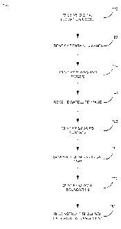
[0014] Figure 1 illustrates a flowchart of a method for glacial
geomorphologic
mapping in accordance with one or more implementations of various techniques
described herein.
[0015] Figures 2A ¨ 2D illustrate digital elevation models according to
implementations described herein.
[0016] Figures 3A ¨ 3B illustrate satellite images according to
implementations
described herein.
[0017] Figure 4 illustrates a digital elevation model, a satellite image,
and a
glaciological map according to implementations described herein.
[0018] Figure 5A illustrates a glaciological map in accordance with
implementations
described herein.
[0019] Figures 5B-5D illustrate a reconstruction of a sequence of glacial
advancement in accordance with implementations described herein.
[0020] Figure 6 illustrates a computer network into which implementations
of various
technologies described herein may be implemented.
DETAILED DESCRIPTION
[0021] The discussion below is directed to certain specific
implementations. It is to
be understood that the discussion below is only for the purpose of enabling a
person
with ordinary skill in the art to make and use any subject matter defined now
or later by
the patent "claims" found in any issued patent herein.
[0022] The following paragraph provides a brief summary of various
techniques
described herein. In general, a digital elevation model is used to identify
gradients of
an area of interest. The gradients may be used to identify topographical
features in the
area of interest. Topographical features may include ridges and plains. A
satellite
4
CA 02742960 2011-05-06
WO 2010/053741 PCT/US2009/062092
image of the area of interest may be used to identify land-use classes. Land-
use
classes may include swamps and plains. The intersection of topographical
features
and land-use classes may be used to identify glacial features in the area of
interest.
The intersection of ridges and forests may identify lateral or terminal
moraines. The
intersection of swamps and plains may identify ground moraines. Glacial
boundaries
that outline glaciers may be drawn using the glacial features. The advancement
of the
glaciers outlined by the boundaries may then be reconstructed. One or more
implementations of various techniques for glacial geomorphologic mapping will
now be
described in more detail with reference to Figures 1-6 in the following
paragraphs.
[0023] Figure 1 illustrates a flowchart of a method 100 for glacial
geomorphologic
mapping in accordance with one or more implementations of various techniques
described herein. Method 100 will be described with reference to Figures 2A ¨
2D,
which illustrate digital elevation models 210A ¨ 210D according to
implementations
described herein; Figures 3A ¨ 3B, which illustrate satellite images 310A ¨
310B
according to implementations described herein; Figure 4, which illustrates a
digital
elevation model 210C, a satellite image 310B, and a glaciological map 410
according to
implementations described herein; Figure 5A, which illustrates a glaciological
map in
accordance with implementations described herein; and Figures 5B-5D, which
illustrate
a reconstruction of a sequence of glacial advancement in accordance with
implementations described herein.
[0024] Glacial geomorphological mapping may be performed through an
analysis of
the digital elevation model 210A and the satellite image 310A of an area of
interest.
The area of interest may be an area of groundwater management, hydrocarbon
exploration, or other geotechnical projects.
[0025] At step 110, the digital elevation model 210A may be received. The
digital
elevation model may be a digital representation of ground surface topography
or a
subsurface horizon. In one implementation, the area of interest may be
subdivided by
a grid, as shown in the digital elevation model 210A. Each cell 220 of the
grid may
CA 02742960 2011-05-06
WO 2010/053741 PCT/US2009/062092
represent a fixed area within the area of interest. For example, each cell 220
may
represent a 30 meter (m) by 30 m area of terrain. Additionally, the digital
elevation
model 210A may include an elevation for the terrain within each cell 220.
[0026] At step 120, terrain classes may be identified on the digital
elevation model
210A. In other words, a terrain class may be identified for each cell 220 in
the digital
elevation model 210A. Terrain classes may include flat terrain, structured
terrain, and
escarpments. Flat and structured terrains may contain moraines. The
identification of
escarpments may be useful for logistics planning. For example, the
identification of
escarpments may be used to indicate locations where access by vehicles may be
impossible. Also, escarpments may detrimentally affect data collection for
geotechnical
projects due to the scattering of seismic waves.
[0027] In one implementation, the terrain classes may be based on a
gradient value.
In other words, a gradient, or slope, of each cell 220 may be determined. The
cells 220
may then be identified as terrain classes depending on the gradient value for
the cell
220. TABLE 1 illustrates example gradient values for terrain classes.
6
CA 02742960 2011-05-06
WO 2010/053741 PCT/US2009/062092
TERRAIN CLASS GRADIENT
FLAT < 5 ok
STRUCTURED 5 TO 20 %
ESCARPMENT > 20 %
TABLE 1
[0028] In one implementation, the gradient for each cell 220 may be
determined by
comparing the elevations of neighboring cells in a north-south and east-west
direction.
Referring to Figure 2A, for example, the gradient at cell 220-X may be
determined by
the difference in elevation from cell 220-1 to 220-4 (north-south) and the
difference in
elevation from cell 220-2 to 220-3 (east-west).
[0029] After identifying terrain classes, the topography classification may
be further
refined. At step 130, plains and ridges may be identified on the digital
elevation model
210-A. The identification of plains and ridges may be based on the terrain
classes for
each cell 220. In one implementation, a statistical analysis on the identified
terrain
classes may be performed to identify regions of areas as plains or ridges. In
such an
implementation, neighboring cells may be grouped together to form a region.
The
occurrence of certain percentages of terrain classes within a region may be
used to
identify plains, ridges, or some other topography.
[0030] TABLE 2 illustrates the relationship between terrain classes and the
more
refined topographies. As shown, from the digital elevation model (DEM), three
terrain
classes are identified. For regions with strictly flat terrain, plains may be
identified. For
regions with flat terrain and structured terrain, ridges on plains may be
identified. For
regions with strictly structured terrain, mountains may be identified.
Escarpments may
not be further refined.
7
CA 02742960 2011-05-06
WO 2010/053741 PCT/US2009/062092
DEM
FLAT TERRAIN STRUCTURED ESCARPMENTS
TERRAIN
RIDGES ON
PLAINS MOUNTAINS ESCARPMENTS
PLAINS
TABLE 2
[0031] For example, Figure 2B illustrates a digital elevation model 210B
with four
cells identified as terrain classes, three identified as "F" (flat), and one
cell identified as
"S" (structured). These four cells may be grouped into a single region 230, as
shown in
Figure 2C.
[0032] Figure 2C illustrates a digital elevation model 210C. The digital
elevation
model 210C may represent the digital elevation model 210B organized by
regions. In
the digital elevation model 210C, a region 230 may contain the four terrain
classes
illustrated in the digital elevation model 210B. Because the region 230 is 75%
flat
terrain (3 of the 4 cells are flat), the region 230 may be identified as a
plain P, as shown
in Figure 2D.
[0033] Figure 2D illustrates the digital elevation model 210C with all the
regions
identified as "P" (plains), "M" (mountains), "E" (escarpments), and "RP"
(ridges on
plains). It should be noted that the percentage listed here is merely for the
purpose of
illustration, and is not intended to limit implementations described herein.
The
categorization of topographies by percentages may vary in implementations of
various
technologies described herein.
8
CA 02742960 2011-05-06
WO 2010/053741 PCT/US2009/062092
[0034] In one implementation, the statistical analysis may be performed by
creating
a hypsographic curve. A hypsographic curve may be a graph that shows the
proportion
of land area that exists at various elevations by plotting relative area
against relative
height. In such an implementation the local elevation values may be binned
into the
terrain classes, i.e., flat terrain, structured terrain, and escarpments. The
hypsographic
curve may be computed from the cumulative sum of the number of terrain classes
per
region. The identification of plains and ridges may then be determined based
on the
hypsographic curve.
[0035] At step 140, the satellite image 310A of the area of interest may be
received.
In one implementation, the satellite image may be a remote sensing satellite
image.
Remote sensing is the acquisition of information of an object, by the use of
either
recording or real-time sensing device(s) that are not in physical contact with
the object.
The remote sensing satellite image may measure reflected sunlight from the
area of
interest. In one implementation, the satellite image 310A may be a continuous
color
red-green-blue (RGB) image. In such an implementation, the satellite image
310A may
be generated from Landsat bands 7, 4, and 2.
[0036] Similar to the digital elevation models, the area of interest in the
satellite
image 310A may be subdivided by a grid. Each cell of the grid may represent a
region
in the digital elevation model 210C. As shown, the satellite image 310A may
include a
color for each region.
[0037] At step 150, swamps and forests may be identified for each region.
Swamps
and forests are examples of land-use classes that can be distinguished from
each other
based on vegetation type. In one implementation, land-use classes may be
identified
based on the color of the region in the satellite image 310A. Identifying
swamps and
forests may be useful because these land-use classes may contain moraines.
Figure
3B illustrates a satellite image 310B with land-use classes identified based
on the
colors for the regions in the satellite image 310A. TABLE 3 illustrates an
example of
colors and their respective land-use classes.
9
CA 02742960 2011-05-06
WO 2010/053741 PCT/US2009/062092
LAND-USE CLASS COLOR
WATER DARK BLUE
ICE, SNOW, CLOUDS CYAN
INFRASTRUCTURE DARK PURPLE
SOIL, SAND LIGHT PURPLE,
YELLOW
FOREST DARK GREEN
MEADOWS LIGHT GREEN
SWAMPS, PEAT RED
WEATHERED DARK PURPLE TO GRAY
BASEMENT ROCK
TABLE 3
[0038] At step 160, a glaciological map 410 may be generated. The
glaciological
map may contain glacial features. The glacial features may be identified based
on the
identified plains and ridges in the digital elevation model, and the swamps
and forests
in the satellite image. More specifically, the glacial features may be
identified through a
correlation matrix of topography and land-use classes. TABLE 4 illustrates the
correlation matrix. "N/A" stands for not applicable because a swamp cannot
occur on a
ridge.
------____LAND USE SWAMP FOREST
TOPOGRAPHY
PLAINS GROUND NON-GLACIAL
MORAINE
RIDGES N/A TERMINAL/LATERAL
MORAINES
CA 02742960 2011-05-06
WO 2010/053741 PCT/US2009/062092
TABLE 4
[0039] For
example, Figure 4 illustrates the glaciological map 410 generated based
on the identified plains and ridges in the digital elevation model 210C and
the identified
swamps and forests in the satellite image 310B. As shown, ground moraines may
be
identified based on the correlation of plains P and swamps. Lateral or
terminal
moraines may be identified based on the correlation of ridges RP and forests.
All other
regions may be identified as non-glacial.
[0040] At
step 170, glacial boundaries may be identified based on the glacial
features in the glaciological map 410. The boundaries of a single glacier may
be
identified through the identification of a feature group. The feature group
may include a
lateral moraine on each side of a glacier, a terminal moraine at the end of
the glacier,
and a ground moraine disposed between the two lateral moraines and the
terminal
moraine.
[0041] For
example, Figure 5A illustrates a glaciological map 500 with glacial
boundaries 510, 520, and 530. The shading in the glaciological map 500 may
represent lateral, terminal and ground moraines. Each of the boundaries 510,
520, and
530 may represent the outline of one glacier. It
should be noted that not in some
scenarios, moraines may occur outside of a feature group. In such a scenario,
the
moraines may represent an ice sheet, instead of a glacier. For example, the
boundary
530 may represent an ice sheet that is indicated by the occurrence of terminal
moraines.
[0042] At
step 180, a sequence of glacial advancement of the glaciers 510, 520 and
530 may be reconstructed. The sequence of the glacial advancement may be
determined based on the state of preservation of the glacial features in
comparison to
each other. For example, the glacier with glacial features that are best
preserved in
comparison to other glaciers may be the last glacier that advanced.
11
CA 02742960 2011-05-06
WO 2010/053741 PCT/US2009/062092
[0043] In one implementation, the reconstruction may be performed by
displaying
the individual glaciers on the glaciological map 500 in the sequence of
advancement.
Figures 5B-5D illustrate a reconstruction of a sequence of glacial advancement
based
on the glaciers with boundaries 510, 520, and 530, respectively. As stated
previously,
the glacier with the best-preserved features may be displayed last.
[0044] Some useful applications of information provided by glacial
geomorphologic
mapping are summarized in TABLE 5 below.
12
CA 02742960 2011-05-06
WO 2010/053741 PCT/US2009/062092
PREDICTED IMPACT
FEATURE DETECTION
SURFACE
LOGISTICS SEISMIC SIGNAL
NOISE
TERRAIN CLASS VELOCITY LOW SLOW LOW
GRAVEL PINE FOREST AND AND VARIABLE FREQUENT
ACCESSIBLE
co RIDGES GLACIOLOGICAL DEPENDING ON RAYLEIGH
w
rI INTERPRETATION CLAY CONTENTS WAVES
D
I-
<
w BOTTOM
DETERMINES
u_
DEM FOR RS WEATHERING BOTTOM
FOR
.7cI DEPTH OF
TERRAIN CLASS NOT APPLICABLE LAYER, SURFACE
z WATER TABLE
0 WATER FEATURES REFERENCE FOR MULTIPLE
co
< STATICS
GENERATION
w
co
Z
CHANGE OF RISK OF
CHANGE OF POTENTIAL
z TERRAIN CLASS PROPAGATION
REFLECTION
SURFACE ACCESSIBILITY
BOUNDARIES VELOCITY, RISK AND/OR
CHARACTER BOUNDARIES
OF BLOCKAGE
SCATTERING
7CI TERRAIN CLASS VELOCITY 1400
Z WATER INACCESSIBLE MINOR
0 cn WATER FEATURES M/S, NO S WAVES
cn
< w
w rI
co D
I-
CC < VELOCITY - 1400
L11 Li1 TERRAIN CLASSES
2 u_ SWAMP, M/S, NO S SURFACE
SWAMP AND INACCESSIBLE
2 MEADOW MEADOWS WAVES, HIGH MULTIPLES
D
co ATTENUATION
SURFACE AND
7CI TERRAIN CLASS VELOCITY > 2000 FLEXURE
z WATER ACCESSIBLE WAVES,
O co WATER FEATURES M/S
SCATTERING
cn w
< rI
FROM CRACKS
1.11 D
U) 1-
CC <
L.L1 I-1-1 VELOCITY - 2000
1- LL TERRAIN CLASSES
Z SWAMP, M/S, NO S SURFACE
SWAMP AND ACCESSIBLE
MEADOW WAVES, HIGH MULTIPLES
MEADOWS
ATTENUATION
TABLE 5
13
CA 02742960 2011-05-06
WO 2010/053741 PCT/US2009/062092
[0045] Figure 6 illustrates a computing system 600, into which
implementations of
various technologies described herein may be implemented. The computing system
600 may include one or more system computers 630, which may be implemented as
any conventional personal computer or server. However, those skilled in the
art will
appreciate that implementations of various technologies described herein may
be
practiced in other computer system configurations, including hypertext
transfer protocol
(HTTP) servers, hand-held devices, multiprocessor systems, microprocessor-
based or
programmable consumer electronics, network PCs, minicomputers, mainframe
computers, and the like.
[0046] The system computer 630 may be in communication with disk storage
devices 629, 631, and 633, which may be external hard disk storage devices. It
is
contemplated that disk storage devices 629, 631, and 633 are conventional hard
disk
drives, and as such, will be implemented by way of a local area network or by
remote
access. Of course, while disk storage devices 629, 631, and 633 are
illustrated as
separate devices, a single disk storage device may be used to store any and
all of the
program instructions, measurement data, and results as desired.
[0047] In one implementation, area of interest data for the digital
elevation model
210A, and the satellite image 310A may be stored in disk storage device 631.
The
system computer 630 may retrieve the appropriate data from the disk storage
device
631 to process area of interest data according to program instructions that
correspond
to implementations of various technologies described herein. The program
instructions
may be written in a computer programming language, such as C++, Java and the
like.
The program instructions may be stored in a computer-readable medium, such as
program disk storage device 633. Such computer-readable media may include
computer storage media and communication media.
[0048] Computer storage media may include volatile and non-volatile, and
removable and non-removable media implemented in any method or technology for
storage of information, such as computer-readable instructions, data
structures,
14
CA 02742960 2011-05-06
WO 2010/053741 PCT/US2009/062092
program modules or other data. Computer storage media may further include RAM,
ROM, erasable programmable read-only memory (EPROM), electrically erasable
programmable read-only memory (EEPROM), flash memory or other solid state
memory technology, CD-ROM, digital versatile disks (DVD), or other optical
storage,
magnetic cassettes, magnetic tape, magnetic disk storage or other magnetic
storage
devices, or any other medium which can be used to store the desired
information and
which can be accessed by the system computer 630.
[0049] Communication media may embody computer readable instructions, data
structures, program modules or other data in a modulated data signal, such as
a carrier
wave or other transport mechanism and may include any information delivery
media.
The term "modulated data signal" may mean a signal that has one or more of its
characteristics set or changed in such a manner as to encode information in
the signal.
By way of example, and not limitation, communication media may include wired
media
such as a wired network or direct-wired connection, and wireless media such as
acoustic, RF, infrared and other wireless media. Combinations of any of the
above may
also be included within the scope of computer readable media.
[0050] In one implementation, the system computer 630 may present output
primarily onto graphics display 627, or alternatively via printer 628. The
system
computer 630 may store the results of the methods described above on disk
storage
629, for later use and further analysis. The keyboard 626 and the pointing
device (e.g.,
a mouse, trackball, or the like) 625 may be provided with the system computer
630 to
enable interactive operation.
[0051] The system computer 630 may be located at a data center remote from
the
area of interest. The system computer 630 may be in communication with a
satellite
(either directly or via a recording unit, not shown), to receive signals
indicative of the
satellite image 310A. These signals, after conventional formatting and other
initial
processing, may be stored by the system computer 630 as digital data in the
disk
storage 631 for subsequent retrieval and processing in the manner described
above.
CA 02742960 2011-05-06
WO 2010/053741 PCT/US2009/062092
[0052] While Figure 6 illustrates the disk storage 631 as directly
connected to the
system computer 630, it is also contemplated that the disk storage device 631
may be
accessible through a local area network or by remote access. Furthermore,
while disk
storage devices 629, 631 are illustrated as separate devices for storing input
data and
analysis results, the disk storage devices 629, 631 may be implemented within
a single
disk drive (either together with or separately from program disk storage
device 633), or
in any other conventional manner as will be fully understood by one of skill
in the art
having reference to this specification.
[0053] While the foregoing is directed to implementations of various
technologies
described herein, other and further implementations may be devised without
departing
from the basic scope thereof, which may be determined by the claims that
follow.
Although the subject matter has been described in language specific to
structural
features and/or methodological acts, it is to be understood that the subject
matter
defined in the appended claims is not necessarily limited to the specific
features or acts
described above. Rather, the specific features and acts described above are
disclosed
as example forms of implementing the claims.
16