Note: Descriptions are shown in the official language in which they were submitted.
CA 02746618 2011-07-13
TITLE OF THE INVENTION
AIRCRAFT DOCKING SYSTEM AND METHOD WITH AUTOMATIC
CHECKING OF APRON AND DETECTION OF FOG OR SNOW
This application is a divisional of Canadian patent application Serial No.
2,434,444 filed internationally on December 11, 2001 and entered nationally on
July
11, 2003.
FIELD OF THE INVENTION
The present invention is directed to aircraft docking systems and more
particularly to safety enhancements for aircraft docking systems for automatic
checking of the apron for obstacles before and during docking and for
detection of fog
and snowfall in front of the docking system. The present invention is further
directed
to methods implemented on such systems.
DESCRIPTION OF THE RELATED ART
In recent years, there has been a significantly increased number of passenger,
cargo and other aircraft traffic, including takeoffs, landings and other
aircraft ground
traffic. Also, there has been a marked increase in the number of ground
support
vehicles which are required to offload cargo and to provide catering services
and
ongoing maintenance and support of all aircraft. With that substantial
increase in
ground traffic has come a need for greater control and safety in the docking
and
identification of aircraft on an airfield.
To that end, U.S. Patent No. 6,023,665, issued February 8, 2000, to the same
inventor named in the present application teaches a system for detecting,
identifying
and docking aircraft using laser pulses to obtain a profile of an object in
the distance.
The system initially scans the area in front of the gate until it locates and
identifies an
object. Once the object is identified as an airplane, the system tracks the
airplane. By
using the information from the profile, the system can in real time display
the type of
airplane, the distance from the stopping point and the lateral position of the
airplane.
The modes of operation of the system include a capture mode, in which an
object is
detected and determined to be an aircraft, and a tracking mode, in which the
type of
aircraft is verified and the motion of the aircraft toward the gate is
monitored.
1
CA 02746618 2011-07-13
Referring to Fig. IA, the docking guidance system of the above-referenced
patent, generally designated 10, provides for the computerized location of an
object,
verification of the identity of the object and tracking of the object, the
object
preferably being an aircraft 12. In operation, once the control tower 14 lands
an
aircraft 12, it informs the system that the aircraft is approaching a gate 16
and the type
of aircraft (i.e., 747, L-1011, etc.) expected. The system 10 then scans the
area 19 in
front of the gate 16 until it locates an object that it identifies as an
airplane 12. The
system 10 then compares the measured profile of the aircraft 12 with a
reference
profile for the expected type of aircraft and evaluates other geometric
criteria
characteristic of the expected aircraft type. If the located aircraft, at a
minimum
specified distance (e.g., 12 m) before the stop position, does not match the
expected
profile and the other criteria, the system informs or signals the tower 14,
displays a
stop sign and shuts down.
If the object is the expected aircraft 12, the system 10 tracks it into the
gate 16
by displaying in real time to the pilot the distance remaining to the proper
stopping
point and the lateral position of the plane 12. The lateral position of the
plane 12 is
provided on a display 18 allowing the pilot to correct the position of the
plane to
approach the gate 16 from the correct angle. Once the airplane 12 is at its
stopping
point, that fact is shown on the display 18 and the pilot stops the plane.
Referring to Fig. 113, the system 10 includes a Laser Range Finder (LRF) 20,
two mirrors 21, 22, a display unit 18, two step motors 24, 25, and a
microprocessor
26. Suitable LRF products are sold by Laser Atlanta Corporation and are
capable of
emitting laser pulses, receiving the reflections of those pulses reflected off
of distant
objects and computing the distance to those objects.
The system 10 is arranged such that there is a connection 28 between the
serial
port of the LRF 20 and the microprocessor 26. Through that connection, the LRF
20
sends measurement data approximately every 1/400th of a second to the
microprocessor 26. The hardware components generally designated 23 of the
system
20 are controlled by the programmed microprocessor 26. In addition, the
microprocessor 26 feeds data to the display 18. As the interface to the pilot,
the
display unit 18 is placed above the gate 16 to show the pilot how far the
plane is from
its stopping point 29, the type of aircraft 30 the system believes is
approaching and
the lateral location of the plane. Using that display, the pilot can adjust
the approach
of the plane 12 to the gate 16 to ensure the plane is on the correct angle to
reach the
2
CA 02746618 2011-07-13
gate. If the display 18 shows the wrong aircraft type 30, the pilot can abort
the
approach before any damage is done. That double check ensures the safety of
the
passengers, plane and airport facilities because if the system tries to dock a
larger 747
at a gate where a 737 is expected, it likely will cause extensive damage.
In addition to the display 18, the microprocessor 26 processes the data from
the LRF 20 and controls the direction of the laser 20 through its connection
32 to the
step motors 24, 25. The step motors 24, 25 are connected to the mirrors 21, 22
and
move them in response to instructions from the microprocessor 26. Thus, by
controlling the step motors 24, 25, the microprocessor 26 can change the angle
of the
mirrors 21, 22 and aim the laser pulses from the LRF 20.
The mirrors 21, 22 aim the laser by reflecting the laser pulses outward over
the
tarmac of the airport. In the preferred embodiment, the LRF 20 does not move.
The
scanning by the laser is done with mirrors. One mirror 22 controls the
horizontal
angle of the laser, while the other mirror 21 controls the vertical angle. By
activating
the step motors 24, 25, the microprocessor 26 controls the angle of the
mirrors and
thus the direction of the laser pulse.
The system 10 controls the horizontal mirror 22 to achieve a continuous
horizontal scanning within a 10 degree angle in approximately 0.1 degree
angular
steps which are equivalent to 16 microsteps per step with the Escap EDM-453
step
motor. One angular step is taken for each reply from the reading unit, i.e.,
approximately every 2.5 ms. The vertical mirror 21 can be controlled to
achieve a
vertical scan between +20 and -30 degrees in approximately 0.1 degree angular
steps
with one step every 2.5 ms. The vertical mirror is used to scan vertically
when the
nose height is being determined and when the aircraft 12 is being identified.
During
the tracking mode, the vertical mirror 21 is continuously adjusted to keep the
horizontal scan tracking the nose tip of the aircraft 12.
While the system disclosed in the above-cited patent detects the airplane,
that
system does not detect ground support vehicles or other objects in the apron
of the
docking area. Because of the pilot's limited field of view, the aircraft may
collide
with such ground support vehicles or other objects. Also, the system may give
erroneous warnings in fog or snow, particularly the former.
Fog is most often seen between 10-25m by the system. As that distance is
closer, or in the area of, the stop position, the system will generate a gate
blocked or
ID-fail condition if the capture procedure triggers on the fog. The capture
procedure
3
CA 02746618 2011-07-13
needs a method to recognize that the object captured is most likely fog and is
no
obstruction to the docking procedure once the aircraft appears.
Log files taken during foggy conditions show that fog is reported like a solid
object in front of the system. A sweep into fog often reports close to 100%
echoes,
and the echoes vary in distance only with a few decimeters of each other.
Snowfall is
most often more spread out, giving 60-80% echoes with a spread of 5-10m. Thus,
snow is generally easier to detect, i.e., discriminate from a solid object,
than fog is.
Figs. 2A and 2B show sample images of fog, while Figs. 2C and 2D show sample
images of snow.
SUMMARY OF THE INVENTION
It will be apparent from the above that a need exists in the art for an
aircraft
detection system which overcomes the above-noted problems of the prior art. It
is
therefore an object of the present invention to permit detection of objects in
the apron.
It is another object to support the pilot's judgment as to whether it is safe
to
proceed to the gate or there is a risk of collision.
It is another object of the present invention to permit accurate detection of
fog
and snow.
To achieve the above and other objects, the present invention is directed to a
system and method for aircraft detection in which the apron is automatically
checked
for obstacles before and during docking. As the aircraft may be approaching
the gate
at a high speed, it is essential that checking for obstacles occupy the system
for the
minimum amount of time so that the influence on the docking function is
minimized.
It is assumed to be particularly important that the area is checked which is
swept by
the wings of a narrow-body aircraft or swept by the engines of a wide-body
aircraft. It
is also assumed that it is not so important to check the apron at the bridge
side of the
center line as it is to check the opposed side, as most movements of service
vehicles
take place on the opposed side. Therefore, it is assumed that the scanner unit
can be
mounted such that the optical axis points to the left of the center line,
e.g., 5 , thus
taking maximum advantage of the horizontal scanning range of the system.
The present invention is further directed to a system and method for aircraft
detection in which fog and snowfall are detected by analyzing the laser sweep
triggering the capture condition. If the measured distance to the caught
object is found
to vary randomly (in a non-deterministic way) across the width of the object,
the
4
CA 02746618 2011-07-13
object is considered to be a possible fog/snow condition. A possible fog
condition is
not considered by the system as a valid target for the tracking phase, so that
the
system remains in capture mode. If the fog condition prevails, the system
informs the
pilot/stand operator by displaying a warning message. Under those conditions,
it is
intended that the pilot shall continue, with caution, to approach the stand
area, as the
system will be able to pick up the aircraft as soon as it is seen through the
fog.
When a fog condition has been detected, the display switches from the
standard capture display to a display showing the aircraft type alternating
with a
message such as "DOWNGRADED" or "LOW VISB" to indicate that the system has
downgraded performance due to reduced visibility. A corresponding message is
displayed in the operator panel.
According to an embodiment of the invention, there is provided a
method for identifying a detected object and determining whether an obstacle
is
present in an area near the object. The method comprises (a) projecting light
pulses
onto the object and into the area to generate reflected pulses; (b) receiving
the
reflected pulses in a detector; (c) identifying the object based on the
reflected pulses;
and (d) determining whether the obstacle is present in the area based on the
reflected
pulses, wherein: step (a) comprises (i) projecting a first set of light pulses
onto the
object and (ii) projecting a second set of light pulses into the area; step
(c) is
performed using the reflected pulses from the first set of light pulses; and
step (d) is
performed using the reflected pulses from the second set of light pulses.
According to another embodiment of the invention, there is provided a system
for identifying a detected object and determining whether an obstacle is
present in an
area near the object. The system comprises a light source for projecting light
pulses
onto the object and into the area to generate reflected pulses; a detector for
receiving
the first set of reflected pulses; and a computing device for identifying the
object
based on the reflected pulses and for determining whether the obstacle is
present in
the area based on the reflected pulses; wherein: the light source projects a
first set of
light pulses onto the object and a second set of light pulses into the area;
and the
computing device identifies the objects using the reflected pulses from the
first set of
light pulses and determines whether the obstacle is present using the
reflected pulses
from the second set of light pulses.
5
CA 02746618 2011-07-13
Any embodiment, or combination of embodiments, of the present invention
can be implemented in the system of the above-referenced patent by appropriate
modification.
BRIEF DESCRIPTION OF THE DRAWINGS
Preferred embodiments of the present invention will be set forth in detail
with
reference to the drawings, in which:
Figs. 1A and 1B show the aircraft docking system of the above-cited patent,
which can be modified in accordance with the present invention;
Figs. 2A and 2B show images of fog taken with the aircraft docking system of
Figs. 1A and 1B;
Figs. 2C and 2D show images of snow taken with the aircraft docking system
of Figs. 1 A and 1 B;
Fig. 3 is a drawing showing an area to be checked during apron check;
Fig. 4 is a drawing showing the geometry used in ground suppression during
apron check;
Fig. 5 is a drawing showing the geometry used in calculating vertical scan
angles during apron check;
Figs. 6A and 6B are diagrams of flow charts of the apron scan carried out
during capture and tracking modes, respectively;
Figs. 7A-71 are drawings showing stages in the fog detection procedure;
Fig. 8 is a diagram of a flow chart of the fog detection procedure; and
Figs. 9-11 are diagrams showing flow charts of three alternative algorithms
used by the present invention for fog detection.
DETAILED DESCRIPTION OF THE PREFERRED EMBODIMENTS
Various preferred embodiments of the present invention will now be set forth
in detail with reference to the drawings, in which the same reference numerals
refer to
the same components or operational steps throughout. First, a preferred
embodiment
of the apron checking will be disclosed; then, a preferred embodiment of the
fog
detection will be disclosed. While the two embodiments will be disclosed
separately,
it will be understood that they can be combined.
The apron-checking embodiment will be disclosed first. Since it is
conventional for ground support vehicles to approach an aircraft from the
left, the
6
CA 02746618 2011-07-13
preferred embodiment of the apron checking will be disclosed on that basis. Of
course, if it is anticipated that ground support vehicles will approach from
the right,
the apron checking can be varied accordingly.
Fig. 3 shows the area to be checked. It is assumed that the docking system has
a horizontal scanning range of 10 . As the 50 scan to the right of the center
line
covers only an area for which the pilot needs no support, the apron check is
made
only to the left of the center line. The 10 angle of the apron scan will
cover the area
in front of the right wing tip to an inner limit of about 60 in for aircraft
of the same
size as a B737. It will also cover the area swept by the inner engine of a
wide-body
aircraft into about 48 in. That corresponds to a nose position of about 45 m
for a B737
and a nose position of about 25 in for B747. It is assumed that the smallest
object to
be detected has the following dimensions: a width of 1 in and a height of 1.5
in. The
apron check feature ignores any echoes closer than stop position (nose) + 5m,
in order
to allow ground personnel to be present at the parking position.
Fig. 4 shows a scanning geometry used for ground suppression. To reduce
problems with ground echoes, e.g. due to heaps of snow, all echoes below a
certain
level g above ground are ignored. Thus, an echo is ignored if the measured
distance l
is larger than lg, given by
lg = (laserheight - g) / sin y
where y = 8 + R
8 = arcsin (laserheight / lmax)
(3 = Vertical angle referenced to "reference beam"
lmax = Length of "reference beam" achieved during centerline
definition.
laserheight= The value automatically calculated during the center
line definition procedure.
In case there are several laserheight values due to ground level variations,
the value is
used that corresponds to the actual "Covered range" given below.
The vertical angle of the scans for the apron check will be explained with
reference to Fig. 5. In order to detect an object with a height h the scan
thus has to hit
the object at a height between g and h.
Several scans are used to cover the area to be checked. The angular step dy
required between the scans is given by the formula
7
CA 02746618 2011-07-13
dy = ~12 x [(h - g) / (laserheight - g)J x sin 2)1
As an example, assume that an area from 30 m out to 100 m is to be covered.
This gives the following two examples of coverage and scan angles yin degrees.
For
both examples, laserheight = 5 m. In the first example, h = 1.5 m, and g = 0.5
m.
The resulting values of y and of the covered range m are given in Table 1:
Covered
range
y M
7.6 34
6.8 38
6.0 43
5.3 48
4.7 54
4.2 61
3.8 68
3.3 77
3.0 87
2.6 98
In the second example, h = 2 m, and g = 1 m. The resulting values of y and of
the
covered range m are given in Table 2:
Covered
range
y m
7.6 30 - 37
5.7 37 - 47
4.3 47 - 61
3.2 61 - 78
2.4 78 -102
The angular step in the horizontal scan will now be described. Assume that a
lm wide object is to be detected at 100 m. Assume that 3 hits on the object
are
required. That means that the resolution must be < arctan(0.3/ 100) '& 0,17
which
means that 1 microstep per measurement is required, i.e., the same as for the
normal
scan.
8
CA 02746618 2011-07-13
Apron checking can be performed during capture mode, tracking mode or
both. Apron checking during capture mode will be described first with
reference to
Fig. 6A. Then, apron checking during tracking mode will be described with
reference
to Fig. 6B.
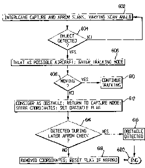
During the capture mode, in step 602, the normal capture scans ( 5 ) are
interleaved (every second scan) with apron check scans from -15 to -5 . The
vertical
angle y of the apron check scan is changed between each scan according to
Table 1 or
2 above in order to cover the -15 to -5 sector.
If an object is detected in step 604, it is treated in step 606 as a possible
aircraft, and the tracking mode is entered to check whether the object is
moving
(calculated speed above a certain value) in step 608. If it is moving,
tracking
continues in step 610. If it is not moving, it is considered in step 612 to be
an
obstacle; the system returns to capture mode, stores the representative
coordinates of
the obstacle and sets an "Obstacle Flag" indicating that there is an obstacle
on the
apron. If the obstacle is detected during a later apron check in step 614, the
object is
considered to be detected in step 616; otherwise, the coordinates are removed
in step
618. If there is no stored obstacle coordinates, the flag is reset. The apron
check ends
in step 620.
During capture mode, one apron check sweep is performed for every three
capture sweeps. The apron check sweeps cycle through the apron area from
capture
point to the stop position, but never closer than 30m from the system,
scanning to the
side of the centerline (-15 to -5 degrees). If an object is detected, the
docking
procedure is paused with a gate-blocked condition. If the object disappears,
the
docking procedure will resume. To be considered as a blocking object, the
object
must remain in position over at least 2 checks, indicating that a non-moving
object is
present in the apron area.
The apron check during capture uses a fixed set of checkpoints, selected to
cover the designated apron check area. When an object is detected in the apron
check
area, the system will halt the capture process and display a warning message.
At that
time, the system will cycle through the apron check points only, increasing
the speed
of apron check. This will continue until all apron check points report the
area clear, at
which time the system will revert to capture mode.
9
CA 02746618 2011-07-13
For the apron area to be considered free, at least 1.5 cycles through the
apron
check points must report no object, in order to keep up with a moving object
in the
apron check area.
During the tracking mode, as soon as possible after the aircraft ID is
verified
in step 623, an apron check scan is done in step 634 and is repeated about
every 2
seconds (e.g., after every 8 scans). The vertical angle of the apron check
scan is
chosen such that the scan covers the area from 5 m behind the aircraft nose
and
inwards. If a non-moving object is detected in step 636, then in step 638, the
"Obstacle Flag" is set, and tracking mode continues. If it is determined in
step 640
that the object disappears, the flag is reset in step 642. As long as the flag
is set during
tracking mode, the message WAIT - APRN BLKD is displayed in step 644. The
process ends with step 646.
During the tracking mode, one apron check sweep is performed for every 8
nose sweeps (4Hor+4Ver). The apron check sweep is synchronized not to coincide
with the engine-id sweeps, as that would result in too much time spent not
tracing the
aircraft. Engine-id sweeps also have a periodicity of 8 nose sweeps. For an
unsuccessfully identified aircraft, the sweep sequence would be: Ver Hor Ver
Hor
Motorld Ver Hor Ver Hor ApronCheck ... repeated until id fail at 12m from
stop.
The apron check sweep looks at a fixed position relative to the aircraft nose.
If
an object is found, the docking procedure is paused with an apron-blocked
condition.
If the object disappears, the docking procedure will resume.
When an object has been found in front of the aircraft, the system will lock
the
apron check sweep to the object, regardless of the position of the aircraft,
in order not
to allow the apron check sweep to slide off the object as the aircraft
continues to move
forward. The system must still keep track of the nose of the aircraft, but not
give any
lead-in information. If the aircraft is found to be at the stop position while
an apron-
blocked condition exists, the system ignores the apron-blocked condition and
displays
the STOP message.
The apron check will not continue once the aircraft is closer than 4m to the
stop position or the aircraft is closer than 30m from the system, in order not
to
interfere with stop position accuracy.
The fog detection embodiment will now be described. First, an overview will
be given with reference to the drawings of Figs. 7A-71 and the flow chart of
Fig. 8.
CA 02746618 2011-07-13
In step 802, the aircraft docking system is started in accordance with the
normal procedure. The normal display of Fig. 7A is shown. The stand area,
shown in
a top-down view in Fig. 7B, is covered in fog.
The echo picture of the fog appears in Fig. 7C. In step 804, the system
considers the fog to be an object large enough to generate a capture.
In step 806, the system analyzes the data of Fig. 7C and determines that the
captured object is most likely fog or snow. The system remains in the capture
mode,
but activates the low-visibility display, in which the display of Fig. 7D
alternates with
that of Fig. 7E.
In step 808, the aircraft approaches the stand. A top-down view of the
approach is shown in Fig. 7F.
In step 810, as the aircraft approaches the stand, the system sees the
aircraft
through the fog. The echo picture is shown in Fig. 7G.
In step 812, as the system catches the aircraft, the distance and azimuth
display of Fig. 7H is activated.
In step 814, the docking proceeds in accordance with normal operation, and
the display of Fig. 71 is shown. The procedure ends in step 816.
Three algorithms for fog detection will now be presented. Each of the
algorithms discriminates an echo picture resulting from fog from an echo
picture
resulting from solid objects. The algorithms are based on the fact that the
spatial
distribution of echoes from fog is to a certain extent random. Any of the
algorithms
can be used during capture mode to avoid a "Gate blocked" or "ID fail" message
caused by echoes from fog. Specific numerical ratios used in the algorithms,
such as
50% or 60% of all echoes, are determined empirically.
The first algorithm will be explained with reference to the flow chart of Fig.
9.
The first algorithm includes a preconditioning phase 902 for preconditioning
the echo
pattern and a criteria phase 904 in which the preconditioned echo pattern is
compared
to criteria to determine whether the pattern results from fog or a solid
object.
The preconditioning phase 902 includes two assessments of the spatial
distribution of the echoes. There are n echoes having distances l;, i = 1 to
n, from the
laser range finder. If it is determined in step 906 that the distance between
two
adjacent echoes V -44 < 0.5m, then both echoes are rejected in step 908. If it
is
determined in step 910 that the distance change for three adjacent echoes in a
row has
the same sign, the three echoes are rejected in step 908.
11
CA 02746618 2011-07-13
The criteria phase 904 applies two criteria to the preconditioned data. If it
is
determined in step 912 that fewer than 60% of all echoes remain after the
preprocessing (that is, that more than 40% are rejected in step 908), than it
is
determined in step 914 that there is no fog. Otherwise, it is determined in
step 916
whether the mean distance 'mean = 20 2 in and v = 4 1 in, where
1mean = 0/n and
v = An x 11;2)- (El,)21/[n x (n-1)].
If so, it is determined in step 918 that there is fog. Otherwise, it is
determined in step
914 that there is no fog. The algorithm ends in step 920.
The second algorithm will be explained with reference to Fig. 10. The second
algorithm is similar to the first algorithm and also has a preconditioning
phase 1002
and a criteria phase 1004.
The preconditioning phase 1002 begins with step 1006, in which 1mean and v
are calculated for all of the echo data in accordance with the equations given
above.
For each echo i, the distances to adjacent echoes are assessed in step 1008.
If Ili-l;-,I <
0.5 in or Ili-l;+1j < 0.5 in, then echo i is rejected in step 1010.
The criteria phase 1004 applies two criteria to the preconditioned data. If it
is
determined in step 1012 that the remaining number of echoes is less than n/2,
or in
other words, more than half of the echoes were rejected in step 1010, then it
is
determined in step 1014 that there is no fog. Otherwise, in step 1016, lmean
and v are
recalculated for the remaining echoes to give 'mean-new and Vnew. If 1lmean-
new-lmeanI <2m
and I vne,,-vJ<2m, it is determined in step 1018 that there is fog. Otherwise,
it is
determined in step 1014 that there is no fog. The algorithm ends in step 1020.
The third algorithm will be explained with reference to Fig. 11. The third
algorithm is based on two assumptions. First, it is assumed to be a
characteristic of
fog that little or no correlation exists between the positions of adjacent
echoes.
Second, it is assumed to be a characteristic for solid objects that most
groups of three
or four adjacent echoes are positioned such that an approximately straight
line can
connect them. In the third algorithm, a preconditioning step is not required,
and all
echo values are used.
In step 1102, for each echo i, a deviation u; is calculated from a straight
line,
extrapolated from the two echoes to the left, as follows:
u; = iii - 2l;_1 + li-21.
12
CA 02746618 2011-07-13
In step 1104, the variable v, is calculated as follows:
v; = 1 if u; ? U, where U = empirically decided, e.g. = 1;
v,=0 if u;<U.
In step 1106, the following is calculated:
S =1v,.
In step 1108, it is determined whether S > V, where V is an empirically
determined value, e.g., V = 50. If so, it is determined in step 1110 that
there is fog.
Otherwise, it is determined in step 1112 that there is no fog. The algorithm
ends in
step 1114.
Each laser sweep which triggers the standard capture conditions is analyzed
for possible fog conditions before control is passed to the tracking
algorithm. During
fog analysis, only echoes from 8m of the distance to the caught object and no
closer
than 2m and no farther away than 35m from the laser are considered. For the
valid
echoes from the object, a count of direction changes is made, where a
direction
change is defined as an echo 2dm or more away from its neighbour, and with a
different heading (inwards/outwards) from that of the previous distance step.
The two
first direction changes are not counted, as they are expected to be found on a
real
aircraft; only the changes beyond the first two are counted. If the ratio of
valid echoes
from the object to the number of direction changes is lower than 8 (echoes per
change), the echo pattern is considered to be caused by fog or snow. If fog or
snow is
detected, the capture phase continues. If more than 4 of the last 8 capture
sweeps
report a fog condition, a `low visibility' condition is considered to exist,
and the
display switches to `low visibility' message.
While various preferred embodiments of the present invention have been set
forth above, those skilled in the art who have reviewed the present disclosure
will
readily appreciate that other embodiments can be realized within the scope of
the
invention. For example, numerical values are illustrative rather than
limiting. In
particular, empirically determined values can be varied as different
conditions at
different airports warrant. Also, the techniques disclosed above can be
adapted to
3o hardware other than that disclosed. Moreover, techniques disclosed for
detecting fog
can be used for any form of condensation or precipitation (snow, rain, sleet,
etc.).
Therefore, the present invention should be construed as limited only by the
appended
claims.
13