Note: Descriptions are shown in the official language in which they were submitted.
CA 02747128 2013-01-25
31560-12
- 1 -
ATLAS ELEKTRONIK GmbH
SebaldsbrOcker Heerstralle 235, 28309 Bremen
Unmanned underwater vehicle and method for operating an
unmanned underwater vehicle
The invention relates to an unmanned underwater vehicle having at least one
sensor unit
which can be used to acquire sensor information relating to objects in an area
surrounding the underwater vehicle. The invention also relates to a method for
operating
an unmanned underwater vehicle, at least one sensor unit being used to acquire
sensor information relating to objects in an area surrounding the underwater
vehicle.
In contrast to manned missions, unmanned underwater vehicles can reach
greater working depths and can operate in environments which are too
dangerous for divers or manned underwater vehicles. Unmanned underwater
vehicles are also able to perform most of the tasks which were previously
carried
io out by larger research ships. Unmanned underwater vehicles therefore
afford a
large cost advantage over manned systems. Unmanned underwater vehicles can
be roughly subdivided into remotely controlled underwater vehicles (ROV =
Remotely Operated Vehicle) and autonomous underwater vehicles (AUV =
Autonomous Underwater Vehicle).
Remotely controlled underwater vehicles (ROV) are generally remotely
controlled
via a connection cable, usually by a human operator. Remotely controlled
underwater vehicles are preferably used for missions with locally limited,
more
detailed investigations under real-time conditions, the underwater vehicle
often
also having to act on an object under water, for example for repair purposes.
Autonomous underwater vehicles (AUV) perform their respective mission without
being continuously monitored by human operators but rather follow a specified
mission programme. Autonomous underwater vehicles comprise their own power
CA 02747128 2011-07-22
¨ 2 ¨
supply and do not require any external communication during the mission. After
the mission programme has been carried out, the autonomous underwater
vehicle independently surfaces and is then recovered. An autonomous
underwater vehicle is particularly suitable for large-scale reconnaissance
under
water and investigates the underwater environment, generally without contact
with sensed objects under water.
Unmanned underwater vehicles, that is to say both remotely controlled
underwater vehicles (ROV) and autonomous underwater vehicles (AUV),
o comprise at least one sensor unit which can be used to acquire sensor
information relating to objects in the area surrounding the underwater
vehicle.
Remotely controlled underwater vehicles often use a camera, as a sensor unit,
to
record images under water which are displayed to the operator in order to make
it possible for the operator to carry out an inspection or manipulations under
real-
time conditions using images of an object. Autonomous underwater vehicles
require sensor units to sense objects in the area surrounding the underwater
vehicle for various tasks. The sensor information is used, inter alia, for
navigation. The sensor information is also used to locate objects or to
calculate
manoeuvres for the closer inspection of underwater objects which have been
found.
Both large-scale reconnaissance or investigation and locally limited work
under
real-time conditions are required in a multiplicity of underwater missions,
for
example when inspecting and, if necessary, repairing offshore installations,
for
example pipelines. Walls, in particular vertical walls, often need to be
examined
under water, the walls having to be covered over a long inspection range
according to their length under water. If damage is detected, the damage must
be diagnosed in more detail and repaired, if necessary. Such fields of use of
unmanned underwater vehicles are, for example, harbour inspections including
the inspection of channel walls, quay walls, sheet pile walls etc., in
particular with
regard to the undermining of such underwater walls. Harbour inspections can
also concern the examination and possibly manipulation of hulls. During such
underwater missions, objects having extensive structures and contours need to
CA 02747128 2013-01-25
31560-12
- 3 -
be investigated and must be comprehensively scanned by the sensors of the
underwater vehicle. In this case, the structures and contours of the
investigated
object may change, with the result that the sensor unit cannot sense the
structures and contours of the object at all or can sense them only
inadequately.
The sensor units are permanently mounted in known unmanned underwater
vehicles but it is not possible to adapt the sensor unit to changing
structures and
contours of the object to be investigated. Control manoeuvres of the
underwater
vehicle are therefore regularly needed to bring the sensors into new positions
lo with respect to the underwater body to be investigated in order to
obtain suitable
sensor information. Adjustment manoeuvres therefore often have to be carried
out by an operator when investigating extensive underwater bodies such as
underwater walls or ship walls, thus slowing down the performance of the
mission.
So-called pan-tilt units are known from monitoring technology, which are a
mechanical gearbox, which can carry out tilt movements and pan movements in
a coordinated manner, and in which a camera tracks a target. Such pan-tilt
units
are used, in particular, to monitor rooms, the camera sensing movements, in
particular of persons who intrude. Such pan-tilt units are not suitable for
use in
unmanned underwater vehicles since the camera and possibly the light source
are manually set and oriented by an operator and a large amount of time is
therefore needed to adjust the sensors. On account of the remotely controlled
operation of the pan-tilt units, such systems are, in particular, not suitable
for
autonomously operating underwater vehicles (AUVs).
The invention is based on the problem of sensing structures and contours of
objects under water as quickly and accurately as possible.
CA 02747128 2013-11-28
27935-22
- 3a -
According to one embodiment of the invention, there is provided an unmanned
underwater vehicle having at least one sensor unit which can be used to
acquire
sensor information relating to objects in an area surrounding the underwater
vehicle,
wherein the at least one sensor unit is arranged such that it can be moved in
a
circumferential direction of the underwater vehicle circumferentially with
respect to a
longitudinal axis of the underwater vehicle or an axis running parallel to the
longitudinal axis and can be positioned in the circumferential direction by a
positioning device based on the sensor information.
According to another embodiment of the invention, there is provided a method
for
operating an unmanned underwater vehicle, at least one sensor unit being used
to
acquire sensor information relating to objects in an area surrounding the
underwater
vehicle, wherein the sensor information is specified to a positioning device
and the
positioning device positions the sensor unit based on the sensor information
by
moving the sensor unit in a circumferential direction of the underwater
vehicle
circumferentially with respect to the longitudinal axis of the underwater
vehicle or an
axis running parallel to the longitudinal axis.
CA 02747128 2013-01-25
31560-12
- 4 -
According to some embodiments of the invention, the at least one sensor unit
is arranged
such that it can be moved, in particular pivoted, rotated or displaced, in a
tangential direction
of the underwater vehicle and can be positioned in the tangential direction by
a
positioning device to which the sensor information can be specified.
Movability in
the tangential direction denotes movability tangentially with respect to the
longitudinal axis of the underwater vehicle or an axis running parallel to the
longitudinal axis. The tangential direction is, in particular, a direction of
rotation
about this longitudinal axis or the axis running parallel to the longitudinal
axis.
The tangential direction in which the sensor unit is movably arranged is on a
io plane which is perpendicular to a longitudinal axis of the underwater
vehicle. The
longitudinal axis corresponds to straight-ahead travel of the underwater
vehicle.
Moving the sensor unit makes it possible to very quickly orient the sensor
unit to
an area to be investigated and to adapt it to the structure of the object to
be
investigated. In this case, the sensor unit can be automatically oriented
according
to the invention by the positioning device without having to involve an
operator.
As a result of the fact that the sensor unit can be oriented, the sensor unit
can
sense a considerably larger area by changing the sensing range of the sensor
unit in the case of large structures, for example quay walls or hulls. In
addition,
the orientation according to the invention makes it possible to sense
structures
and contours which are at a particular position outside the sensing range of
the
sensor unit. For example, an orientation of the sensor unit may also sense
overhangs, in particular at precipices, or generally objects under water. When
large structures are sensed with the inventive positioning of the sensor unit,
the
sensed structures are advantageously stored in order to compare the data
relating to these structures, which have thus been stored, with the sensor
information from a subsequent investigation of the same structure. As soon as
changes or unusual features of the structure are sensed, the sensor unit is
positioned in the direction of the unusual feature found, for example damage
to a
harbour wall or abnormalities on a hull.
The sensor unit is advantageously arranged on a sensor carrier which is
arranged on a hull of the underwater vehicle such that it can be rotated in
the
CA 02747128 2011-07-22
¨ 5 ¨
tangential direction, that is to say the sensor carrier can be rotated about
the
longitudinal axis or an axis running parallel to the longitudinal axis. The
positioning device can use an actuator of the sensor carrier to rotate the
sensor
carrier, with the result that the sensor unit is pivoted and is thus
positioned in the
tangential direction of the underwater vehicle. During positioning, the
rotational
angle position of a rotatable sensor carrier is changed in the tangential
direction.
In one preferred refinement of the invention, the sensor carrier is in the
form of a
rotatable sensor head which is arranged on a bow of the underwater vehicle. In
o this manner, the leading region of the underwater vehicle is sensed in an
optimal
manner and the sensor unit is also provided at a location which is favourable
in
terms of flow mechanics.
In another advantageous embodiment of the invention, the sensor carrier is in
the
form of a sensor ring which is rotatably arranged on the periphery of the
hull.
The sensor unit is advantageously arranged such that it can be pivoted in a
pivoting direction tangentially with respect to an axis which runs
perpendicular to
the longitudinal axis or perpendicular to an axis running parallel to the
longitudinal axis. The sensor unit can be positioned by the positioning device
in
this pivoting direction. In this manner, the positioning device can orient the
sensor unit accurately and quickly with respect to the object to be
investigated or
the section of a structure both in the tangential direction and in the
pivoting
direction, that is to say with a movement via two axes of rotation.
With one preferred automatic orientation of the sensor unit, the positioning
device
positions the sensor unit according to a criterion based on the sensor
information. In this case, the sensor information determined by the sensor
unit is
evaluated and reacts to itself while the sensor unit is being displaced, with
the
result that the sensor unit can be positioned very quickly according to a
particular
criterion.
CA 02747128 2011-07-22
¨ 6 ¨
For each item of sensor information acquired, a distance from an object is
advantageously determined and the magnitude of the distances determined is
used as the criterion for positioning the sensor unit. In this case, the
information
relating to the distance from the object can be derived from the respective
sensor
information in every rotational angle position of the sensor unit. In order to
acquire the sensor information relating to objects in the area surrounding the
underwater vehicle, an active sensor unit comprising a transmitting unit and a
receiver unit, which can be used to acquire reflected sensor information, is
advantageously provided. The distance to the target can be determined in this
io manner from the sensor information. In this case, the active sensor unit
also
senses emission-free objects, for example objects which do not emit any noise.
In one advantageous embodiment of the invention, the active sensor unit
comprises optical sensors whose camera provides images as the sensor
information. The structure of the object to be investigated and also local
areas of
particular interest, for example damage, can easily be seen or derived from
the
photographs from the camera.
In one preferred embodiment of the invention, the sensor unit comprises
acoustic
sensors. A sonar sensor unit can be used to determine distances to an object
and the direction to this object.
A contour of an object in the area surrounding the underwater vehicle is
advantageously determined from the acquired sensor information and the sensor
unit is oriented in a direction specified for the determined contour. In this
case,
the positioning device senses a variation in sensor information from different
directions and determines the respective distance to the object in the area
surrounding the underwater vehicle. The contour of the object in the area
surrounding the underwater vehicle can be derived from the variation in
distances which is obtained in this manner. The sensor unit is then oriented
in
the direction of one of the items of sensor information which is selected from
the
variation in sensor information according to a criterion specified for the
determined contour. In one advantageous embodiment, specifications for
CA 02747128 2011-07-22
¨ 7 ¨
orienting the sensor unit are electronically stored or can be stored for
particular
contours in the positioning device.
This sensor information is advantageously provided by a multi-beam active
sonar, that is to say a sonar having a multiplicity of reception directional
characteristics which point in different directions. In a sensing sector, the
multi-
beam active sonar provides a multiplicity of items of sensor information, each
of
which is assigned a direction and a distance. With suitable tuning of the
active
sonar and corresponding evaluation, contours are derived from the acoustic
io sensor information and can also be optically displayed if necessary, for
example
on monitors. A sonar also enables accurate positioning of the sensor carrier
and
adaptation to changing contours and structures in situations in which optical
sensor units are less effective, for example in murky waters.
The criterion for orienting the sensor unit is preferably the magnitude of the
determined distances. In this case, an orientation according to the longest
distance determined or the shortest distance may be specified for the
respective
contour. Particular distances according to particular angular relationships
between the sensor unit and the structure or contour to be investigated can
also
be specified as a criterion for the orientation.
In the case of flat contours such as underwater walls, the sensor unit is
advantageously oriented in the direction corresponding to the shortest
distance
from an object, with the result that the sensing range of the sensor unit is
optimally used. In the case of other contours, other criteria may be specified
for
the distance in order to position the sensor unit. For example, in the case of
corner structures, for example when investigating a corner enclosed by a wall
on
a base, the sensor unit is advantageously positioned at the furthest distance
which was previously determined when evaluating the sensor information.
If, during operation of the underwater vehicle, it is determined that the
current
position of the sensor unit no longer corresponds to the criterion specified
for the
contour, the position of the sensor unit is tracked to the criterion. The
rotatable
CA 02747128 2011-07-22
¨ 8 ¨
sensor carrier is moved with the at least one sensor unit in an automated
process
until the orientation corresponds to the specified criterion. Automatic
orientation
is thus carried out, for example, during operation of a remotely controlled
underwater vehicle without an operator having to intervene.
Another advantageous embodiment of the invention provides for transmitting a
light image in order to orient a sensor unit with respect to an object to be
investigated, the sensor unit sensing a projection of the light image on the
object.
When evaluating the sensor information, the projection is compared with the
transmitted light image and an incongruity between the projection and the
original
light image is determined and the geometry of the original light image is used
as
the criterion for positioning the sensor unit. The sensor carrier and thus the
sensor unit are oriented according to a discrepancy which has been determined,
by being moved in the circumferential direction and/or pivoting direction, in
such
a manner that the projection sensed in this manner is as congruent with the
light
image as possible. This procedure is based on the knowledge that, when the
light image does not impinge on a surface in a perpendicular manner, the
projection is distorted according to the inclined structure of the object.
The light image is preferably produced using laser light, with the result that
there
is a long range. For this purpose, a laser projection system is provided in
the
sensor carrier, for example the sensor head.
Changing the orientation of the sensor unit also changes the geometry of the
projection, from which it is possible to draw conclusions with regard to the
difference between the actual position of the sensor unit and the optimum
desired sensor unit. A light image with parallel lines is advantageously used,
an
oblique, that is to say no longer parallel, position of the lines on the
projection
resulting in the event of a non-frontal position of the sensor unit. A light
image
with crossed bundles of lines each with parallel lines is preferably
transmitted,
thus making it possible to draw conclusions with regard to the orientation of
the
sensor unit in two dimensions.
CA 02747128 2013-01-25
=
31560-12
- 9 -
The movable sensor carrier advantageously comprises both a laser projection
system
with a camera as an optical sensor unit and an active sonar (multi-beam
sonar). In
this case, both systems can be used together if necessary
Further advantageous embodiments emerge from the exemplary embodiments which
are explained in more detail below using the drawing, in which:
Fig. 1 shows a schematic side view of an unmanned underwater vehicle,
Fig. 2 shows a schematic side view of a second exemplary embodiment
of an
unmanned underwater vehicle,
Fig. 3 shows a flowchart of an orientation of a sensor unit,
Fig. 4 and Fig. 5
show plan views of a rotatable sensor carrier of an unmanned
underwater vehicle according to Fig. 1 or Fig. 2 in the area surrounding
an underwater body, and
Fig. 6 shows a schematic illustration of an object having the
projection from an
optical sensor unit of the underwater vehicle according to Fig. 1 or
Fig. 2.
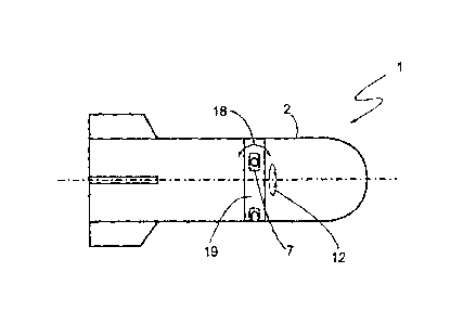
Fig. 1 shows an unmanned underwater vehicle 1 having a hull 2 which is
cylindrical,
in particular tubular or torpedo-shaped, at least in sections and on the stern
3 of
which a main drive 4 is arranged. In the exemplary embodiment shown, the
unmanned underwater vehicle 1 is an autonomous underwater vehicle which
carries
out its mission without communication. For this purpose, a control device 5,
to which
operating software and/or a mission programme stored in a memory 6
specify/specifies control information, is arranged in the hull 2.
CA 02747128 2011-07-22
,
- 10 ¨
The underwater vehicle 1 has at least one sensor unit 7 whose sensor
information 8 is input to the control device 5. The control device 5 uses its
operating software to autonomously determine control commands for the
operating devices of the underwater vehicle 1, for example for navigation or
for
controlling the drive 4 and steering the underwater vehicle 1, on the basis of
the
control information specified to it by the mission programme 6 and the sensor
information 8.
In an alternative exemplary embodiment, the unmanned underwater vehicle 1
io can be remotely controlled and receives control information 9, via a
connection
cable 10, from a system platform which is illustrated as an ocean vessel 11 in
Fig. 1. The system platform 11 may also be stationary in order to carry out
underwater inspections tied to a location using a remotely controlled
underwater
vehicle (ROV).
The at least one sensor unit 7 is arranged such that it can be moved in a
tangential direction 12 of the underwater vehicle and can be positioned in the
tangential direction 12 by a positioning device 13. The positioning device 13
comprises an electronic computer unit which is used to evaluate the received
sensor information 8 according to operating software and to determine output
values. The positioning device 13 may be an independent computer unit or else
may be integrated in the control device 5.
In this case, the tangential direction 12 in which the sensor unit 7 can be
positioned is tangential with respect to the longitudinal axis 14 of the
underwater
vehicle 1. In this case, the longitudinal axis 14 corresponds to the straight-
ahead
travel of the underwater vehicle 1 and runs between its stern 3 and its bow
15.
The sensor unit 7 can be moved in the circumferential direction 12 by virtue
of
the fact that the sensor unit 7 is arranged on a sensor carrier which is
arranged
on the hull 2 such that it can be rotated in the tangential direction 12. In
the
exemplary embodiment shown, the sensor carrier is in the form of a rotatable
sensor head 16 which is arranged on the bow 15 of the underwater vehicle 1.
CA 02747128 2011-07-22
- 11 ¨
The bow 15 provides a location, which is favourable in terms of flow
mechanics,
for arranging the sensor unit 7.
The sensor head 16 can be rotated in the circumferential direction 12 by an
actuator 17, the actuator 17 receiving actuating commands from the positioning
device 13 for setting the rotational angle position of the sensor head 16 and
for
the associated positioning of the sensor unit 7.
In addition to the tangential direction 12, the sensor unit 7 is also arranged
such
that it can be moved in a pivoting direction 18, that is to say can be pivoted
about
an axis perpendicular to the longitudinal axis 14 or perpendicular to an axis
parallel to the longitudinal axis 14 of the underwater vehicle 1. The sensor
unit 7
can be positioned by the positioning device 13 in the pivoting direction 18.
For
positioning in the pivoting direction 18, the sensor head 16 comprises
actuating
means which are not illustrated here and are controlled by the positioning
device
13. An actuator which is controlled by the positioning device 13 by means of
actuating commands may likewise be provided as a means for positioning in the
pivoting direction 18.
In the exemplary embodiment according to Fig. 2, the rotatable sensor carrier
is
in the form of a sensor ring 19 which is rotatably arranged on the periphery
of the
hull 2. The rotatable sensor ring 19 is provided instead of the rotatable
sensor
head 16 in the exemplary embodiment according to Fig. 1. The sensor ring 19
can be rotated in the tangential direction 12 of the underwater vehicle 1, the
sensor units 7 of the sensor ring 19 being able to be positioned in a pivoting
direction 18, as already described with respect to Fig. 1. The sensor ring is
advantageously hinge-mounted and comprises a housing made of a material
which transmits the operating signal from the sensor unit 7. The sensor ring
19
advantageously consists of glass, which is transparent, and/or of a material
which transmits sound.
For the rest, the unmanned underwater vehicle 1' according to Fig. 2
corresponds to the design already described with respect to Fig. 1. In
particular,
CA 02747128 2011-07-22
¨ 12 ¨
the sensor units 7 are positioned in the tangential direction 12 and in the
pivoting
direction 18 by a positioning device which is not illustrated in Fig. 2, with
the
result that optimum orientation with respect to an object to be investigated
is
effected.
The sensor unit 7 is an active sensor comprising a transmitting unit and a
receiver unit, with the result that the sensor unit can sense signals
transmitted
from it after reflection at an object and can provide corresponding sensor
information 8 relating to the object. In particular, the respective distance
to the
io target can be derived from the sensor information 8 from an active
sensor unit.
The sensor unit 7 which is used to position the sensor head 16 may be an
optical
sensor unit or a sonar sensor unit.
The sensor head 16 may have a plurality of sensor units 7 which are
distributed
in the tangential direction, with the result that rotational movements of the
sensor
head 16 are reduced during positioning. In one advantageous exemplary
embodiment, both optical sensor units and sonar sensor units are arranged on
the sensor head 16 or else further sensor units for investigating the area
surrounding the underwater vehicle 1 are provided. Of the sensor units
arranged
on the sensor head 16, at least one is used to position the sensor head 16 and
is
connected to the positioning device 13. In this case, the sensor signals 8
from
the sensor unit 7 used for positioning can also be used to orient other sensor
units arranged on the sensor head 16. Corresponding algorithms can be stored
in the positioning device.
In one preferred exemplary embodiment, the sensor head 16 comprises a
camera and a laser projection system as well as an active sonar (multi-beam
sonar).
Since the sensor information 8 is specified to the positioning device 13 and
the
positioning device 13 adjusts and positions the sensor device 7, the control
information reacts to itself, with the result that the sensor orientation is
optimized
during the positioning operations.
CA 02747128 2011-07-22
¨ 13 ¨
One exemplary embodiment for positioning the sensor unit 7 is explained below
using the flowchart according to Fig. 3. Proceeding from the start, the
positioning
device acquires the sensor information 8 which may contain information
relating
to an object in the area surrounding the underwater vehicle or contains in the
area surrounding an object. The distance 21 to the object is determined in a
computation operation for distance determination 20. The distance 21
determined is compared with a specified criterion 23 with respect to the
magnitude of the distance in a comparison step 22. In this case, the specified
criterion 23 may be the shortest possible distance or the longest possible
distance or else another statement with respect to the distance.
In the comparison step 22, the distance in the current sensor information 8 is
compared with previously acquired values. If the change in the distance
determined does not correspond to the criterion, an actuating command 24 is
transmitted to the actuator 17. In that case, the rotatable sensor carrier is
rotated
further, with the result that the sensor unit is positioned differently. As
soon as
the distance determined satisfies the criterion, the sensor unit has been
optimally
positioned.
The criterion 23 is specified on the basis of the respective contour of an
object. In
this case, in addition to the comparison step 22, the distance 21 is used in a
contour determination process 25. During the positioning operation, that is to
say
when the sensor carrier moves, the positioning device senses a variation in
sensor information 8 from different directions. The respective distance 21 to
the
object in the area surrounding the underwater vehicle is determined from the
sensor information 8. A contour 26 of the object in the area surrounding the
underwater vehicle can be derived from the variation in distances which is
obtained in this manner. A criterion specification 27 determines the
appropriate
criterion 23 of the magnitude of the distance for the contour 26 determined.
Appropriate criteria 23 are determined and stored in advance for particular
contours 26.
CA 02747128 2011-07-22
¨ 14 ¨
As a result of the positioning according to the specified magnitude of the
distance
21, the sensor unit is automatically oriented in the direction of that item of
sensor
information 8 which is selected from the variation in sensor information
according
to the criterion 23 specified for the contour 26 determined.
Exemplary embodiments of the orientation of the sensor unit according to the
distance determined are shown in Fig. 4 and Fig. 5, each of which illustrates
a
plan view of the sensor head 16 of an underwater vehicle. In the exemplary
embodiment according to Fig. 4, the underwater vehicle is in front of a flat
contour, for example a vertical harbour wall 28. As soon as the sensor unit 7
of
the sensor head 16 locates the harbour wall 28, the sensor unit 7 is
positioned. In
order to position the sensor unit 7 with respect to the wall 28, the sensor
head 16
is rotated in the circumferential direction 12, as a result of which the
sensor unit 7
transmits and receives signals in different rotational angle positions and the
positioning device therefore senses a variation in sensor information 8, 8',
8", 8"
from the sensor unit 7 from different directions.
For each item of acquired sensor information 8, 8', 8", 8", a distance to the
object, the wall 28 in this case, is determined. The contour of the wall 28 in
the
sensing range of the sensor unit can be determined from the different
distances
in different directions. After the contour of the object, namely the flat
surface of a
wall 28 in this case, has been determined, the sensor unit 7 is brought into a
rotational angle position which corresponds to the direction of that item of
sensor
information 8, 8', 8", 8" whose determined distance corresponds to the
specified
criterion for the magnitude of the distance, for example corresponds to the
criterion of the longest distance. In the exemplary embodiment of a flat
surface
shown, the shortest distance is specified as the criterion for the magnitude
of the
distance for the purpose of positioning the sensor unit 7.
As long as the distances in the current sensor information become shorter, the
sensor head continues its positioning movement. The criterion of the shortest
distance is determined to have been reached as soon as a distance which
becomes longer is determined for the first time. The sensor unit 7 is thus
CA 02747128 2011-07-22
¨ 15 ¨
accurately frontally positioned in front of the wall and senses the largest
possible
area in this case.
The sensor unit 7 is positioned automatically and thus in a very rapid manner.
The automatic positioning and adjustment of the sensor unit makes it possible
to
sense changing structures and to map a plurality of structures in a relatively
short
period of time, for example vertical walls with different structures, hulls or
else
overhangs on underwater mountains. In this case, a sector in the area
surrounding the underwater vehicle, which could be poorly sensed in the
o previous orientation of the sensor unit, can also be investigated by
positioning
the sensor head. When investigating overhangs for example, the sensor can thus
be rotated upwards from a downwardly directed position. In addition, larger
sensor ranges can be sensed as a result of the automatic positioning since the
sensor unit is automatically oriented in the respective optimum position with
respect to the surface to be investigated.
The sensor unit 7 is positioned automatically and independently of an
operator,
with the result that, in the case of a remotely controlled underwater vehicle
(ROV), the vehicle can still be manually controlled, while the sensor unit is
automatically positioned at the same time in the event of changing surface
structures of the objects to be investigated.
If the sensor unit 7 is a sonar, positioning can be effected in a simple
refinement
using a three-point measurement, sensor information being recorded in three
different positions of the sensor carrier and the respective distance from the
reflective object being determined therefrom. The direction of the shortest
distance is selected for positioning the sensor unit from the variation in
three
distances according to the criterion specified for the contour, that is to say
the
shortest distance in the case of a flat surface. The sensor information is
preferably acquired by a multi-beam active sonar, with the result that a
variation
in a plurality of items of sensor information from different directions is
provided
for the purpose of determining the contour.
CA 02747128 2011-07-22
¨ 16 ¨
For different contours, different criteria for determining the direction from
the
variation in the determined sensor information and associated distances are
specified to the positioning device. Fig. 5 shows, by way of example, a
situation
in which an object to be investigated forms a corner 29. This situation is
typical of
the investigation of harbour installations, where vertical walls 28, for
example,
have been erected on a base 30. Accurate investigation and quick and precise
positioning are desirable, in particular, in the region of the base 30 in
order to
detect undermining of the wall 28. When investigating corners 29, the longest
distance is specified for this contour as the criterion for the magnitude of
the
distance, according to which the sensor unit 7 is positioned.
In the manner already described with respect to Fig. 4, a variation in sensor
information 8, 8', 8" is sensed during a movement of the sensor head 16 in the
circumferential direction 12. If the presence of a corner contour results from
evaluation of the sensor information 8, 8', 8", the longest distance is
specified as
the criterion for positioning the sensor unit 7. The sensor unit 7 is
automatically
positioned in the direction of the sensor information 8 with the longest
distance to
the underwater object, which corresponds exactly to the orientation with
respect
to the corner 29.
Fig. 6 illustrates the positioning of an optical sensor unit, the sensor unit
7 (Figs.
1 to 4) transmitting a light image 31 and sensing a projection 32 of the light
image 31 on a wall 28 to be investigated. The sensor unit comprises a laser
projection system and a camera for this purpose. The high energy density of
the
laser light makes it possible to project light images 31 onto the structures
to be
investigated even in murky waters.
If the wall 28 is not frontally in front of the sensor unit, the projection 32
is
distorted. In order to optimally orient the sensor unit with respect to that
area of
the wall 28 which is to be investigated, a deviation of the geometry of the
projection 32 from the transmitted light image is determined and the sensor
unit
is positioned in such a manner that the projection 32 is as congruent with the
CA 02747128 2011-07-22
¨ 17 ¨
original light image 31 as possible. The (original) geometry of the light
image 31
is used by the positioning device as the criterion for orienting the sensor
unit 7.
In the exemplary embodiment shown, the light image 31 has two crossed
bundles of lines each with parallel lines 33, 34. These line structures can be
precisely represented using the laser light from the laser projection system.
When the light image 31 is projected onto a wall 28 which is oblique with
respect
to the sensor unit, the projection 32 will not reproduce the crossed bundles
of
lines in a parallel manner but rather in a tilted or crooked manner. The
suitable
io orientation measure can be derived from the angle between the lines
which were
originally parallel. The light image 31 with crossed bundles of lines and the
two-
dimensional information relating to the surface of the wall 28 to be
investigated,
as obtained therewith, can be used to precisely match and adapt the sensor
unit
to the structure of the wall 28 by means of positioning in the tangential
direction
12 and pivoting direction 18 (Fig. 1).
All of the features mentioned in the abovementioned description of the
figures, in
the claims and in the introductory part of the description can be used both
individually and in any desired combination with one another. Therefore, the
disclosure of the invention is not restricted to the described and/or claimed
combinations of features. Rather, all combinations of features should be
considered to be disclosed.