Note: Descriptions are shown in the official language in which they were submitted.
CA 02748178 2011-06-22
WO 2010/078455 PCT/US2009/069860
Mobile Image Search and Indexing System and
Method
Cross-Reference to Related Application
[0001] This application claims priority under 35 U.S.C. 119(e) to U.S.
Provisional Application No. 61/141,547, filed December 30, 2008 entitled
"Mobile
Image Search and Indexing System and Method," and is a continuation-in-part of
U.S. Application No. 12/645,231 filed December 22, 2009 entitled "System and
Method for Initiating Actions and Providing Feedback by Pointing at Object of
Interest," U.S. Application No. 12/645,243, filed December 22, 2009 entitled
"System
and Method for Exploring 3D Scenes by Pointing at a Reference Object," and
U.S.
Application No. 12/645,248, filed December 22, 2009 entitled "System and
Method
for Linking Real-World Objects and Object Representations by Pointing," the
entire
contents of which are incorporated herein by reference.
Field of the Invention
[0002] The present invention generally relates to computer-implemented systems
and methods for image searching and indexing. More specifically, the present
invention relates to computer-implemented systems and methods that are used
for
image searching and indexing that may be incorporated in whole or in part a
mobile
device.
Background of the Invention
[0003] The ability of people to quickly differentiate and categorize objects
visually enables the assessment of situations before taking deliberate
actions. These
deliberate actions may be based on a person's brain pattern recognition that
matches
context information, such as location, orientation, and time/date in deciding
the
identity of the object. For example, a person may see a hole in a sidewalk and
walk
around it to avoid being injured. "Context" as it is used for this purpose may
be
influenced by other factors including culture, background, and/or education.
[0004] Currently, there are conventional image search engines, e.g., "Google
Image Search," that conduct web-based searches for images according to query
terms.
"Google" is a registered trademark of Google Inc. However, conventional image
1
CA 02748178 2011-06-22
WO 2010/078455 PCT/US2009/069860
search engines do not take into account enough context information about the
image to
help determine the identity of the actual image content. For example when a
system
user types "apple" as a query into an image search engine, the search engine
only will
consider the name of the image or words (tags) associated with the image on a
webpage. As such, search results for such a query have produced many false-
positive
responses. As an example, if the image search query word entered is "pepper,"
the
search results may return images of a black Labrador dog named "Pepper," as
well as
pictures of green "peppers," when the intent of the system user was for images
of the
vegetable "pepper."
[0005] It would be very helpful to have tools or systems to improve the
probability of receiving images more closely related to the desired intent of
a system
user's query if image searching technology was incorporated in pointing
systems that
are used to identify objects or sets of objects that are present in a person's
(system
user's) visual scene. To be more effective these tools or systems would need
to
acknowledge an awareness of the system user's surroundings. More particularly,
it
would be important for such tools or systems to make accurate image searching
decisions based on the consideration of the system user's surroundings.
[0006] Desired tools or systems of the type just described would be of
particular
interest to mobile system users, such as travelers or tourists, who often find
themselves in situations that are unfamiliar or where they encounter foreign
objects.
These mobile tools would need to have the ability to accept information from a
wide
variety of data sources and provide accurate and timely results directed to
images
related to the system user's visual scene. Due to the proliferation of network-
connected mobile devices, including cellular telephones, Personal Data
Assistants
(PDAs), and ruggedized or "tough" minicomputers, platforms are readily
available for
such tools and systems.
[0007] Although mobile devices, such as cellular phones, PDAs, and
minicomputers, are available and affordable, their information systems are
typically
tailored to specific computer-based data services. Further, conducting image
searches
using these devices are awkward and difficult given they require information
to be
input using miniaturized keyboards, which is time consuming as well as
difficult.
Additionally, protective clothing or the need to conduct ongoing surveillances
makes
such devices impractical for military combat use.
2
CA 02748178 2011-06-22
WO 2010/078455 PCT/US2009/069860
[0008] Even if data entry for small mobile devices, such as cellular phones
and
PDAs, could be automated, commercial databases typically rely on semi-
structured
data to produce results that are then ranked by the relevancy of keywords and
word
order, which is not particularly conducive to these types of mobile devices.
As an
example, consider the photo-sharing database FLICKR (http://www.flickr.com),
which uses semi-structured data to provide picture "matches" for system users.
"FLICKR" is a registered trademark of Yahoo, Inc. The accuracy of the results
depends on the text entered, not only by the system user, but by the person
assigning
descriptions to the photo, e.g., keyword tags attached to the picture. Thus,
entering
the keyword "apple" in FLICKR produces over 100,000 potential returns with
pictures
that range from fruits to clothing styles to computers. These results would
fall short of
answering the system user's actual question: "apple" that is fruit.
[0009] Noting the foregoing, there is a need for increased accuracy,
timeliness,
and comprehensiveness of image returns for mobile users that want information
through visual images relating to image search queries formulated by these
mobile
users. More specifically, with regard to "accuracy," the returned image data
needs to
closely match the system user input. Thus, given the wide variety of entries
that are
possible, probabilities must be assigned to provide the system user with
confidence
that the image data returned is not only accurate but also meaningful given
the input.
With regard to "timeliness," the image data returns need to be speedy, meaning
typically in less than five seconds. Return times are greatly affected by the
amount of
image processing and matching that is required. If there are longer return
times, it will
typically be viewed as unacceptable. With regard to "comprehensiveness," image
data
queries must be able to access as many potential matches as possible. As such,
image
data sources should include analysis of objects in images through unstructured
and
semi-structured, i.e., keywords or tags, methods.
[0010] The present invention overcomes these problems of conventional image
search systems and provides a system and method for image searching and
indexing
that provides accurate, timely, and comprehensive results.
Summary of the Invention
[0011] The present invention includes computer-implemented systems and
methods for image searching and image indexing that may be incorporated in a
mobile
device that is part of a computer-implemented object pointing and
identification
3
CA 02748178 2011-06-22
WO 2010/078455 PCT/US2009/069860
system. Preferably, the present invention relates to a computer-implemented
mobile
image searching and indexing system ("MISIS") client that may be associated
with
computer-implemented mobile pointing and identification system, such as
described
in U.S. Patent No. 7,245,923, or co-pending U.S. Patent Application No.
12/645,231,
U.S. Application No. 12/645,243, and U.S. Application No. 12/645,248.
According to
the present invention, image searching refers to finding images in a database.
Further,
image indexing refers to analyzing the image context, annotating the content
of
images, and relating the image and this information with a reference system
that
makes it easy to retrieve the information.
[0012] Preferably, the MISIS client that is incorporated in mobile device
includes
a camera, a global positioning system ("GPS") receiver or other positioning
determining unit, and a digital compass. The MISIS client also may have local
storage associated with it and the MISIS client connects wirelessly to a MISIS
server
that includes storage or has access to storage. Storage at these locations
will permit
image search result processing either locally on the mobile device including
the
MISIS client or remotely on a MISIS server. The MISIS client is contemplated
to be
expandable to accept other inputs, including infrared for night imaging and
sketches.
This latter use may be helpful when electro-optical visibility is impaired.
[0013] The MISIS client wirelessly connects to MISIS system server that
provides
a computational infrastructure for indexing, storing, updating, and retrieving
images.
The MISIS system server connects wired or wirelessly to storage that includes
a
multimedia content section and a geographic information system ("GIS") data
section.
These are for storing the images and providing contextual information based on
which
images are indexed, including, but not limited to, information about
geographic
locations and the environment surrounding these geographic locations.
[0014] The MISIS client is preferably directed to processing in situ images.
As
such, the MISIS client would be preferably used for still images in geographic
space
taken from the perspective of a system user located near the surface of the
Earth.
Therefore, the orientation of the images would be approximately horizontal.
This
would correspond to a typical tourist's perceptual and cognitive perspective
of a visual
scene during a vacation. However, the present invention contemplates other
kinds of
images, such as highly oblique images, e.g., from the street level up to the
20th floor of
a building, or airborne images from a bird's-eye perspective.
4
CA 02748178 2011-06-22
WO 2010/078455 PCT/US2009/069860
[0015] According to the present invention, mobile device incorporating the
MISIS
client will use the spatial context, i.e., position and orientation, of the
MISIS client to
search and index images. This will enable the image search engine to become
faster
and more effective, and provide fewer false-positive results. The MISIS client
also
will provide quality filtering that minimizes false-positives and false-
negatives. A
mobile device that incorporates the MISIS client for image searches will
improve the
system user's searching ability and the ability to learn about objects in
his/her
surroundings and focus on potential dangers.
[0016] The present invention will be described in greater detail in a
remainder of
the specification referring to the drawings.
Brief Description of the Drawings
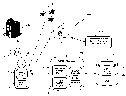
[0017] Figure 1 shows a representative diagram incorporating the MISIS system
of the present invention that includes the MISIS client and MISIS server that
connects
to the MISIS client.
[0018] Figures 2A, 2B, and 2C show projections of image ranges into 2-D plane
at
different pointing directions and viewing angles.
[0019] Figures 3A, 3B, and 3C show different possibilities for false hits for
spatial
image searches based on indexed locations.
[0020] Figure 4 shows an example of infrastructure objects that lie in whole
or in
part in a viewing content cone from a viewing location and infrastructure
objects that
lie outside of the viewing content cone.
[0021] Figures 5A, 5B, 5C, and 5D show a progression of image searching and
Boolean indexing according to the present invention.
Detailed Description of the Present Invention
[0022] The present invention is directed to computer-implemented systems and
methods for image searching and image indexing that may be incorporated in
mobile
devices that is part of object pointing identification systems. More
particularly, the
present invention relates to a computer-implemented MISIS client and MISIS
server
that may be associated with computer-implemented mobile pointing and
identification
systems. The present invention may be used for the searching and indexing of
objects
in in situ images in geographic space taken from the perspective of a system
user
located near the surface of the Earth including horizontal, oblique, and
airborne
perspectives.
CA 02748178 2011-06-22
WO 2010/078455 PCT/US2009/069860
[0023] Referring to Figure 1, generally at 100, a system incorporating the
present
invention will be described. In the Figure 1, mobile device 102 may be a
mobile
device according to U.S. Patent No. 7,245,923, or a system client according to
co-
pending U.S. Application No. 12/645,231, U.S. Application No. 12/645,243, and
U.S. Application No. 12/645,248 that is used for pointing at and identifying
objects of
interest within a system user's visual scene. Accordingly, U. S. Patent No.
7,245,923,
and co-pending U.S. Patent Application No. 12/645,231, U.S. Application
No. 12/645,243, and U.S. Application No. 12/645,248 are incorporated in their
entirety herein by reference.
[0024] According to the present invention, mobile device 102 includes MISIS
client 104, camera 106, digital compass 124, local storage (not shown)
associated with
MISIS client 104, and a GPS receiver (not shown) for carrying out the method
of the
present invention. Digital compass 124, the local storage, and GPS receiver
may not
be exclusively dedicated to MISIS client and may carry other tasks for the
mobile
device and still be within the scope of the present invention.
[0025] MISIS client 104 connects to MISIS server 108 via a wired or wireless
connection. Preferably, MISIS client 104 connects to MISIS server 108 via a
wireless
connection, such as the Internet 105. MISIS server 108 includes at least
geospatial
search engine 110, image search engine 112, and
Search/Navigate/Track/GeoTag/GeoBlog/Advertise ("SNTGGA") unit 114. MISIS
server has storage unit 115 associated with it that preferably stores at least
multimedia
content at 116 and GIS data at 118.
[0026] According to the present invention, with regard to MISIS server 108,
geospatial search engine 110 is a search engine that is accessible by system
users to
perform search queries related to a geographic or spatial domain, and through
which
system users will receive search results generated by the search engine in
response to
search queries. The geographic search engine is also capable of displaying
other
information about the spatial domain, and through which system users will
receive
such as attributes that link to the spatial domain.
[0027] Image search engine 112 is a specialized search engine for finding
pictures
or images on the web or in a dedicated database. To search for images using
the
image search engine, system users will input search terms, such as keywords,
image
files/links, or click on an image, and the image search engine will return
images
"similar" to the query. The similarity measures used for search criteria
include, but
6
CA 02748178 2011-06-22
WO 2010/078455 PCT/US2009/069860
are not limited, meta tags, color distribution in images, or region/shape
attributes. It is
understood that other similarity measures may be used and still be within the
scope of
the present invention.
[0028] SNTGGA unit 114 is for supporting Location Based Services ("LBS")
processes. LBS are information and entertainment services accessible by mobile
devices through a mobile network. LBS also make use of the geographical
position of
the mobile device. LBS can deliver location-aware content to system users on
the
basis of the geographic position of the mobile device and the wireless
infrastructure.
[0029] Multimedia content section 116 is for storing tagged and indexed
multimedia captured by the MISIS client. Multimedia content section 116
stores, for
example, images, and audio or video files.
[0030] GIS data section 118 is used to provide context for indexing and
storing
multimedia by image search engine 112. GIS data section 118 includes
geographic
data such as geographic points, geographic lines, geographic regions, or 3-D
structures
that are used to describe objects in a spatial domain.
[0031] Again referring to Figure 1, External Data Sources/Content
Providers/Search Engine block 120 preferably connects to MISIS server 108
wirelessly via the Internet 105 and provides access to other multimedia that
is not
locally stored by MISIS server 108 at storage unit 115. For the purpose of the
present
invention, multimedia from External Data Sources/Content Providers/Search
Engine
block 120 may be indexed by MISIS server 108 or multimedia from MISIS client
104
can be linked to External Data Sources/Content Providers/Search Engine block
120
and sent to MISIS server 108. Further, GPS satellites 122 provide latitude and
longitude information to mobile device 102 for determining the position of the
mobile
device, which includes camera 106.
[0032] Digital compass is 114, which preferably is incorporated as part of
mobile
device 102, will define the pointing direction of the camera 106 for purposes
of the
present invention. The pointing direction also will define the centerline of a
viewing
content cone that emanates from camera 106. According to the present
invention, this
viewing content cone is used for purposes of searching and indexing an image
for
identifying images relating to objects of interest, such as building 126, with
a high
degree of accuracy and reliability.
[0033] Referring to Figure 1, when a system user takes a picture or a movie of
a
building or landmark, such as shown at 126, with a mobile device that includes
MISIS
7
CA 02748178 2011-06-22
WO 2010/078455 PCT/US2009/069860
client 104, that picture is sent to MISIS server 108 where the image is tagged
and
indexed by image search engine 112. The tagged and indexed image is then
stored in
multimedia content section 116 for later retrieval as a result of a system
user query.
[0034] Referring to Figures 2A, 2B, and 2C, projections of image ranges into a
two-dimensional ("2-D") plane from different pointing directions and with
different
viewing angles are shown generally at 200, 220, and 230, respectively. In
Figure 2A,
location 202 is a point from which the projection emanates. Preferably, a
mobile
device incorporating the MISIS client of the present invention would be
located at
location 202. The pointing direction of the mobile device located at 202 is
shown in
phantom at 201. Given viewing angle 204, rays 206 and 208 define viewing field
210
for the mobile device in a 2-D plane.
[0035] Referring to Figure 2B, the mobile device at 222 is shown with pointing
direction 221 shown in phantom. Viewing angle 223 may be the same or different
from viewing angle 204 and Figure 2A. The viewing angle will depend on the
mobile
device. Given viewing angle 223, rays 224 and 226 define viewing field 228 for
the
mobile device in a 2-D plane.
[0036] Referring to Figure 2C, the mobile device at 232 is shown with pointing
direction 231 shown in phantom. The viewing angle for a new mobile device at
232 is
shown at 233. Given viewing angle 233, rays 234 and 236 define viewing field
238.
As shown in Figure 2C, the viewing field of the mobile device at 232 is much
less
than the viewing field of the mobile device at 202 in Figure 2A and the mobile
device
at 222 in Figure 2B.
[0037] Preferably, the mobile devices at 202, 222, and 232 in Figures 2A, 2B,
and
2C, respectively, will include camera 106 (Figure 1). Therefore, each viewing
field
will originate from the camera location on the mobile device with a center of
the field
being the pointing direction in which a picture is taken. The projected range
of the
viewing field in the 2-D plane will be based on the horizontal viewing angle
derived
from the camera's focal length at the time the picture was taken. The viewing
angle
may vary considerably based on the type of camera objective, wide-angle,
typically
between 60 and 100 , or telephoto, typically between 10 to 15 . The viewing
angle
may be altered using these parameters if in fact the camera has a zooming
capability.
[0038] Conventional systems for indexing of in situ images have been limited
to
the time the picture was taken, any keywords added as metadata, or some form
of
color distribution. However, GPS-enabled cameras have permitted the indexing
of
8
CA 02748178 2011-06-22
WO 2010/078455 PCT/US2009/069860
images based on the camera's location. These GPS features have provided at
least a
first level of spatial context available for image searching. The spatial
information
provides location detail for indexing but yields high false-positive and
potentially
false-negative hit rates when searching because the camera location is not
directly
related to what is being actually captured on the image. Further, an
assumption that
the camera location is a good surrogate for the image content also is not
reliable. For
example, any objects that are at the camera location, which is from where from
a
picture is taken, will not be included in the picture. Therefore, GPS location
alone is
not sufficient context for increased reliability of image searching and
indexing as will
be shown in Figure 3.
[0039] Figures 3A, 3B, and 3C, generally at 300, 320, and 330, respectively,
show
different possibilities for false hits for spatial image searches based on
indexed
locations. Referring to Figure 3A, the actual captured image is shown at 302.
This
image would be stored in a system database. GPS-enabled camera 304 is shown at
location 306. The viewing angle of camera 304 is shown at 303. The viewing
field
for camera 304 will be defined by rays 308 and 310 formed by viewing angle 303
considering the focal length of the lens of camera 304. At location 306 of
image 302,
there is a high probability of false-positive hits because only the camera is
located
within the image search area. More particularly, none of the image content
would be
located in the viewing field.
[0040] Referring to Figure 3B, GPS-enabled camera 304 is shown at location
322.
Again, the viewing angle of camera 304 is shown at 303. The viewing field of
camera
304 will be defined by rays 308 and 310 formed by viewing angle 303
considering the
focal length of the lens of camera 304. Given the location of camera 304 at
322, there
will be fewer false-positive hits than in Figure 3A, but only nearby content
will be
included in the results while more likely content in area 326 of image 302
would be
excluded because only a small portion of the image falls within the viewing
field.
[0041] Referring to Figure 3C, GPS-enabled camera 304 is shown at location
332,
which is outside image area 302. As in Figures 3B and 3C, the viewing field of
camera 304 will be defined by rays 308 and 310 formed by viewing angle 303
considering the focal length of the lens of camera 304. Given the location of
camera
304 at 332 outside image area 302, there will be a high probability of false-
negatives
hits because of this camera location. Further, a large majority of the
potential objects
would be missed in area 336 of the image.
9
CA 02748178 2011-06-22
WO 2010/078455 PCT/US2009/069860
[0042] As has been shown with respect to Figures 3A, 3B, and 3C, the content
of
an in situ image is constrained by the pointing direction of the camera at the
time of
image recordation and the viewing angle in a conventional indexing model.
[0043] The present invention integrates the GPS-enabled capabilities of
cameras
along with the viewing direction and viewing angle for each image so that a
much
more accurate assessment of the content of the in situ image is carried out.
According
to the present invention, preferably, spatial parameters that are used for the
more
accurate assessment of content of in situ images include location information
captured
by a GPS receiver, pointing direction by a digital compass, and the camera
angle by
the object's focal length at the time of recording of an image. The
combination of
these parameters will generate a content viewing field (viewing content cone).
This
viewing content cone will provide a much more accurate reference system for
indexing potential infrastructure content captured in an image.
[0044] According to the present invention, the viewing content cone depth may
be
defined by additional parameters, which include, but are not limited to, the
horizon or
visual impairments, such as fog or smoke. Further, viewing field depth may be
a
default value set by the System Administrator. Although the present invention
preferably focuses on the depth of the content viewing field in a 2-D plane (a
viewing
content cone), it is understood other shapes, including three-dimensional ("3-
D")
shapes, are within the scope of the present invention. For example, 3-D
conical or
pyramid shapes are within the scope of the present invention.
[0045] The viewing content cone according to the present invention provides a
quality filter for searching an image. As a quality filter, the viewing
content cone will
consider static objects of the image that are not included in the viewing
content cone
as not being part of the image and, therefore, cannot become false-positives
when
searching. This will be described in more detail referring to Figure 4.
[0046] Referring to Figure 4, generally at 400, an image is shown that
includes
objects 410, 412, 414, 416, 418, 420, and 422. According to the present
invention, a
camera at location 402 has viewing angle 404. Given viewing angle 404, rays
406 and
408 formed by the focal length of the lens of the camera 402 will define
viewing
content cone 425. Therefore, according to the present invention, viewing
content cone
425 acts as a quality filter. As such, objects 418, 420, and 422 would lie
within the
cone and be considered part of the image. It is noted that although object 422
is
partially in the cone, it still would be consider within the cone. Objects
410, 412, 414,
CA 02748178 2011-06-22
WO 2010/078455 PCT/US2009/069860
and 416 lie outside viewing content cone 425 and, therefore, are not
considered part of
the image. As such, using the method of the present invention, false-positive
hits are
reduced in carrying out the search aspects of the present invention.
[0047] MISIS indexing according to the present invention is based on the
content
of the object-based GIS datasets stored in storage 115 at 118. These datasets
contain
the footprints of individual geospatial instances or landmarks as they are
used in
spatial cognition and communication. These datasets may also contain 3-D
representations of the objects in the viewing content cone.
[0048] The present invention links a viewing content cone with the GIS
datasets
for the purpose of MISIS spatial content-based indexing and searching.
Further, the
use of a spatial index according to the present invention will allow for fast
identification and recognition of objects that are visible from the system
user's
specific point of view. This point of view is a major consideration because it
is the
point from which indexing takes place. It is understood that the system user's
point of
view would mean at least the location of the system user's camera that is part
of the
MISIS client.
[0049] Preferably, the linking process according to the present invention will
be
based on predetermined indexing trees. These indexing trees may be used for
indexing objects contained in images of the environment. For purposes of the
present
invention, reference to "indexing objects" means identifying objects contained
in an
image, annotating the image accordingly, and linking the image to the indexing
tree in
a database. Although the following four indexing trees will be described, it
is
understood that more or less than these four indexing trees may be used and
still be
within the scope of the present invention.
[0050] BSP: A Binary Space Partitioning ("BSP") Tree organizes objects within
a
space according to a cutting plane. The cutting plane is used to categorize
objects in
the space as either being in "front" or in "back" of the plane. For example,
consider a
cube and a cutting plane that divides the cube into equally sized partitions.
If the view
direction is based on the cutting plane, objects encompassed by the partitions
can now
be described as being in front of the cutting plane or in back of the cutting
plane. This
process is iteratively applied to each partition, until the partitions conform
to some
criteria, such as containing only a single object.
[0051] Octree: The space around the origin point is divided up into eight
octants.
Each octant is marked occupied or free according to whether there is any
object
11
CA 02748178 2011-06-22
WO 2010/078455 PCT/US2009/069860
occupying that location in the environment to be represented. Each occupied
octant is
then divided again into eight subspaces and the process continues recursively
until
sufficient resolution has been achieved. More particularly, the Octree method
iteratively partitions space in regular cubes until the spatial units are
fully contained in
the leaves of the tree. Again consider the cube containing a set of objects as
a starting
point, the cube will be subdivided into eight uniform cubes. This process is
iteratively
applied until each object is mapped into the tree.
[0052] R-Tree: The space is split into hierarchically nested, and possibly
overlapping, minimum bounding rectangles. Each node of an R-tree has a
variable
number of entries (up to some pre-defined maximum). Each entry within a non-
leaf
node stores two pieces of data: a way of identifying a child node, and the
bounding
box of all entries within this child node. For example, consider a 2-D plane
that
contains a set of objects. This plane is subdivided into minimal bounding
rectangles
with each containing a set of minimum bounding rectangles. This process is
iteratively applied on each minimum bounding rectangle until each minimum
bounding rectangle contains a set of individual objects that is less than a
predetermined maximum number.
[0053] KD-Tree: The KD-tree is a binary tree in which every node is a k-
dimensional point. Every non-leaf node generates a splitting hyperplane that
divides
the space into two subspaces. Points left to the hyperplane represent the left
sub-tree
of that node and the points right to the hyperplane represent the right sub-
tree. The
hyperplane direction is chosen in the following way: every node split to sub-
trees is
associated with one of the k-dimensions, such that the hyperplane is
perpendicular to
that dimension vector. So, for example, if for a particular split, the "x"
axis is chosen,
all points in the sub-tree with a smaller "x" value than the node will appear
in the left
sub-tree and all points with larger "x" value will be in the right sub-tree.
As an
example, consider a 2-D plane containing a set of objects, this plane is split
into two
partitions, with each partition containing the same number of objects. The
resulting
partitions are further partitioned according to the same method until each
partition
contains less than a predetermined number of objects.
[0054] These indexing trees are used in combination with thematic data from
External Data Sources/Content Providers/Search Engine block 120 and multimedia
content section 116 linked to spatial objects to identify contents in an image
and
annotate the image accordingly. Therefore, according to the present invention,
this
12
CA 02748178 2011-06-22
WO 2010/078455 PCT/US2009/069860
combination supports efficient and fast retrieval of subsets of objects for
query
processing. Further, as the indexing trees provide information about the
topological
setup of the image, reliable indexing of the image takes place within the
viewing
content cone.
[0055] According to the present invention, the MISIS index is generated by
intersecting the viewing content cone with a spatial data set that includes
the area in
which the image is taken. The data set can be either 2-D or 3-D. The
intersection that
is based on a spatial indexing tree mechanism identifies the objects that are
candidates
for indexing. Following this, the image is updated with information about
image
content, i.e., thematic data about spatial objects in the image, and spatial
content, i.e.,
position and orientation, and the spatial indexing tree is updated with
information
about available images.
[0056] Preferably, the indexing and updating workflow according to the present
invention includes four process steps. First, the system user captures some
multimedia, such as a picture, with their mobile pointing device that includes
a MISIS
client. Second, the media (the picture) is sent to the MISIS server where it
is tagged,
annotated, an indexed based on the spatial context from location and
orientation
information captured by the MISIS client at the time of picture creation.
Third, the
annotated and indexed media is stored in a multimedia database. Fourth, a
second
system user uses a MISIS client to query, find, and retrieve media based on
the stored
context information that tagged and annotated the media.
[0057] As new media is submitted to the MISIS server, the MISIS indexing
system is updated to include all additions and changes. Spatial context, such
as
location and orientation, are used to index the media, which will mean that
when a
system user is taking a picture on their vacation with their cell phone, these
pictures
will be tagged automatically. The tags will describe, for example, what the
picture is
of, such as the "Parthenon, Athens, Greece" or "8 Elm Street, Orono, Maine
04473."
[0058] According to the present invention, two incremental settings of the
MISIS
index are distinguished according to Boolean process that will be described
referring
to Figures 5A, 5B, 5C, and 5D. Referring to Figure 5A, shown generally at 500,
a
scene is shown having two images taken from two index points, point P1 at 502
and
point P2 at 504. According to the pointing direction, viewing angle, and focal
length
of the lens of the camera at point P 1, viewing content cone 506 is generated.
As
shown, viewing content cone 506 captures objects 510, 512, and 514.
13
CA 02748178 2011-06-22
WO 2010/078455 PCT/US2009/069860
[0059] Again referring to Figure 5A, according to the pointing direction,
viewing
angle, and focal length of the lens of the camera at point P2, viewing content
cone 520
is generated. Viewing content cone 520 captures objects 512, 514, 522, and
524. As
is also shown in Figure 5A, objects 530 and 532 are not captured by viewing
content
cone 506 or 520, and, therefore, are not considered part of the image.
[0060] Referring to Figure 5B, generally at 540, searching window 542 is shown
with respect to the scene that includes objects 510, 512, 514, 522, 524, 530,
and 532.
In Figure 5B, in a search for images, it is seen that search window 542
includes no
objects found in viewing content cone 506 that relates to point P1 at 502.
However, it
is seen that object 522 is found in viewing content cone 520 that relates to
point P2 at
504.
[0061] Referring to Figure 5C, generally at 550, searching window 552 is shown
with respect to the scene that includes objects 510, 512, 514, 522, 524, 530,
and 532.
In Figure 5C, in a search for images, it is seen that search window 552
includes
objects 510, 512, and 514 found in viewing content cone 506 that relates to
point P1 at
502. It is also seen that search window 552 includes objects 512 and 514 found
in
viewing content cone 520 that relates to point P2 at 504. Accordingly, objects
512
and 514 are found in both viewing content cones while only object 510 is found
in
viewing content cone 506.
[0062] Referring to Figure 5D, generally at 560, searching window 562 is shown
with respect to the scene that includes objects 510, 512, 514, 522, 524, 530,
and 532.
In Figure 5D, in a search for images, it is seen that search window 562
includes no
objects found in viewing content cone 506 that relates to point P 1 at 502. It
is also
seen that search window 562 includes object 524 found in viewing content cone
520
that relates to point P2 at 504.
[0063] The results of the processing according to Figures 5A, 5B, 5C, and 5D
are
a list of objects that will be used to tag and annotate the image.
[0064] The MISIS Boolean process described with respect to Figures 5A, 5B, 5C,
and 5D determine whether or not an image contains a particular infrastructure
object
or conversely whether an infrastructure object is shown only within a
particular image.
This process may be carried out using an index over 2-tuples, which can be
stored in
and retrieved from a relational database that is part of MISIS server 108 or
other
storage location including on the MISIS client. The information that is
retrieved may
be, for example, the image that shows the South side of 11 Oak Street and the
north
14
CA 02748178 2011-06-22
WO 2010/078455 PCT/US2009/069860
side of 8 Elm Street. The retrieval of information using an index over 2-
tuples can be
very rapid with retrieval times preferably within seconds. An example of an
index
over 2-tuples includes, but is not limited to, the following: <object ID,
image ID>
<image ID, object ID>.
[0065] The MISIS Boolean process enables at least three types of queries:
(1) What images are available for object X?
(2) What objects are shown in image A?
(3) Is object X shown on image A?
[0066] The results of the first two queries include sets of identifiers that
can be
logically combined with results of a number of these types of queries through,
preferably, SQL query statements. The two sets of identifiers preferably are a
set of
image identifiers and a set of object identifiers. These results can serve as
input for
visual browsing or for more time-consuming image processing analysis.
[0067] According to present invention, MISIS relevance is attached to each
object
to indicate how well each image represents that object. Preferably, relevance
value ranges between "0" (not represented) and "1" (completely represented).
For
example, a MISIS relevance value could be "0.5." This would mean that the
image
represents the object in a manner that is 50% of what could be a complete
representation of the object. Also, preferably, the relevance value is
generated based
on the criteria that includes, but is not limited to, nearness, centrality,
and overlap.
These three criteria will now be described; however it is understood that more
or less
than these criteria may be used and still be within the scope of the present
invention.
[0068] Nearness: Nearness refers to the position of the object to the camera
location within the viewing content cone. Preferably, this relevance measure
is a
higher value the closer the object is located to the camera. However, if an
object is
too close to the camera lens, it will be blurred and the relevance measure for
very
close objects will be lower.
[0069] Centrality: Centrality refers to the object's location with respect to
the
camera's viewing angle. Preferably, this second relevance measure is higher
for
objects that are just closer to the centerline of the viewing content cone and
lower the
closer to the rays that define the limits of the viewing content cone. The
centrality
measure is based on the assumption that objects of major interest tend to be
located at
the center of the picture, while objects that are of lesser interest are
typically located
near the periphery.
CA 02748178 2011-06-22
WO 2010/078455 PCT/US2009/069860
[0070] Overlap: Overlap refers to the capture of the object within a viewing
content cone. Preferably, this third relevance measure is higher for objects
captured
completely and lower for partial pictures of objects. The overlap or
obstruction of
objects in an image will be correlated with information from the spatial
indexing
information from GIS data section 118 to provide metric details for the
measurement
of the overlap criteria.
[0071] The MISIS relevance index is associated with each spatial object in a
viewing content cone. The image index is stored for each object in GIS data
section
118 or in MISIS server 108 at 114, but may also be stored on mobile device
102. The
MISIS image index that is stored preferably includes 6-tuples. An example of a
6-
tuple image index that is stored in MISIS server 108 at 114 and 118, includes,
but is
not limited to, the following: <object ID, image ID, relevance measure, camera
location, camera angle, date/time>. MISIS relevance index enables a system
user to
input the following types of queries:
(1) What are the n most representative images available for object A?
(2) What are the n most representative images available for object A
showing the object from approximately the same direction?
(3) From what perspectives are no images available for object A?
(4) What images show object A from (approximately) opposite
(orthogonal) directions?
[0072] Further, the MISIS relevance index will permit more advanced visual
analyses of images. For example, using MISIS relevance index a system user
could
create a visual walk around an object by sorting the images in a clockwise or
counterclockwise sequence. The system user could also create a visual walk
towards
an object starting from a specific location. The system user could also
geolocate and
track moving objects with respect to infrastructure objects.
[0073] It is understood that the elements of the systems of the present
invention
may be connected electronically by wired or wireless connections and still be
within
the scope of the present invention.
[0074] The embodiments or portions thereof of the system and method of the
present invention may be implemented in computer hardware, firmware, and/or
computer programs executing on programmable computers or servers that each
includes a processor and a storage medium readable by the processor (including
volatile and non-volatile memory and/or storage elements). Any computer
program
16
CA 02748178 2011-06-22
WO 2010/078455 PCT/US2009/069860
may be implemented in a high-level procedural or object-oriented programming
language to communicate within and outside of computer-based systems.
[0075] Any computer program may be stored on an article of manufacture, such
as
a storage medium (e.g., CD-ROM, hard disk, or magnetic diskette) or device
(e.g.,
computer peripheral), that is readable by a general or special purpose
programmable
computer for configuring and operating the computer when the storage medium or
device is read by the computer to perform the functions of the embodiments.
The
embodiments, or portions thereof, may also be implemented as a machine-
readable
storage medium, configured with a computer program, where, upon execution,
instructions in the computer program cause a machine to operate to perform the
functions of the embodiments described above.
[0076] The embodiments, or portions thereof, of the system and method of the
present invention described above may be used in a variety of applications.
Although
the embodiments, or portions thereof, are not limited in this respect, the
embodiments,
or portions thereof, may be implemented with memory devices in
microcontrollers,
general purpose microprocessors, digital signal processors (DSPs), reduced
instruction-set computing (RISC), and complex instruction-set computing
(CISC),
among other electronic components. Moreover, the embodiments, or portions
thereof,
described above may also be implemented using integrated circuit blocks
referred to
as main memory, cache memory, or other types of memory that store electronic
instructions to be executed by a microprocessor or store data that may be used
in
arithmetic operations.
[0077] The descriptions are applicable in any computing or processing
environment. The embodiments, or portions thereof, may be implemented in
hardware, software, or a combination of the two. For example, the embodiments,
or
portions thereof, may be implemented using circuitry, such as one or more of
programmable logic (e.g., an ASIC), logic gates, a processor, and a memory.
[0078] Various modifications to the disclosed embodiments will be apparent to
those skilled in the art, and the general principals set forth below may be
applied to
other embodiments and applications. Thus, the present invention is not
intended to be
limited to the embodiments shown or described herein.
17