Note: Descriptions are shown in the official language in which they were submitted.
CA 02748906 2011-07-04
WO 2010/076646 PCT/1B2009/007908
ENHANCED METHOD AND DEVICE FOR AQUATIC SEISMIC PROSPECTING
The present invention relates to a method and a device which are intended for
aquatic
seismic prospecting. The general principle of this type of prospecting
involves putting in
place a series of seismic cables, or lines, or "streamers", that are parallel
and submerged,
on each of which there are placed at intervals sensors such as hydrophones
and/or
geophones. The cables are then towed at approximately 5 knots (around 9 km/h)
by one
or more boats, and kept separate by divergent panels called paravanes.
According to this same principle one or more other boats, called "source",
provided with
means able to create a wave in the marine environment, generally in the form
of an airgun,
is moved at a distance from the sensor cables. The duly formed waves are
propagated to
the bottom of the sea, then to the different geological layers to be reflected
by the latter,
and are finally collected and measured by said submerged sensors.
The source boat can also be the boat pulling the seismic cables. All the
information is then
processed to produce a three-dimensional (3D) image of the geology of the
seabed,
generally used to determine the possible presence of oil reserves.
This technique has been used for very many years now and is subject to highly
restrictive
implementation requirements. First of all, the dynamic noise due to the towing
of the
cables at 5 knots disturbs the measurement of the waves that are to be
collected.
Furthermore, the hydrodynamic drag resulting from the drag of the cables is
very high,
measured in tens of tons, for example of the order of 70 tons, which means
having to use
very powerful tugboats.
Furthermore, the weight and the hydrodynamic drag induced means that the cable
pulling
the paravanes undergoes a dynamic deformation known as the "piano wire"
effect, in
other words, the deformations of a wire that is made to vibrate during towing.
This leads to
cable fatigue and can cause it to break. This can result in extremely high
replacement
costs, given the immobilization of the device as a whole.
1
CONFIRMATION COPY
CA 02748906 2011-07-04
WO 2010/076646 PCT/1B2009/007908
Furthermore, the cables are generally submerged at a shallow depth, between 5
and
m, which means they are highly sensitive to meteorological conditions, noise
generated
by waves and swell, and a risk of accidents due to surface maritime traffic
with deep
drafts, notably oil tankers, chemical tankers or container ships.
Moreover, known seismic prospecting devices leave shadow areas during
measurement.
In practice, the cables generally have a length of approximately 8 km and are
spaced apart
by approximately 100 m, which leads, for ten or so parallel cables, to a
measurement area
of 1 x 8 km.
Now, the ideal in terms of measurement is to use an isotropic system, that is
to say a
square surface area, for example 8 x 8 km. However, these dimensions are
incompatible
with the towing means that would be needed given the weight, the drag and the
logistics
needed to obtain such a measurement area. Efforts have therefore been made to
remedy
this situation in two ways, in a known manner.
The first attempt, known by the name of 'Wide Azimuth", consists in
compensating the
anisotropy, by the use of one or two boats towing a set of cables, each
forming a
measurement area of 1 x 8 km, and by using 2 to 8 source boats. This system
has two
major drawbacks. First of all, the prohibitive cost resulting from the
investment in
equipment, maintenance and use, because there are 2 to 8 source boats, plus
one or two
tugboats, plus all the cables. The other drawback lies in the fact that the
source boats
each "fire" in turn, and therefore 2 to 8 times less often, which leads to a
very low firing
density.
The second known proposed attempt is disclosed by GB 2435931, in the name of
Western
Geco, which describes a method and device schematically consisting of a
network of
geophone sensors fixed to a two-dimensional structure taking the form of a
mesh or net, or
a three-dimensional structure. The structure has a periphery, called perimeter
or envelope,
kept in shape by dynamic means such as drones or small boats. The latter is
towed
continuously and one or more seismic sources are provided.
2
CA 02748906 2011-07-04
WO 2010/076646 PCT/1B2009/007908
Despite the apparent attraction, theoretically, of the duly proposed device
and method, this
system is nevertheless impossible to implement realistically. In practice, the
duly formed
structure has a gigantic weight and drag and requires the use of means for
keeping it in
shape, that are inordinate and non-standard both technically, and in financial
or budgetary
terms. Furthermore, by construction it offers only a single possible geometry
for the
network of sensors.
According to another aspect, generally, the aim of marine seismic prospecting
is to pick up
or recover the maximum of signals to produce a geological map that is as
precise and
reliable as possible of the areas underlying the seabed. Now, the low-
frequency signals
provide information on very deep reservoirs and are therefore invaluable in
this respect.
However, the low-frequency signals are strongly attenuated by surface
reflection
phenomenon, called "ghost" and due notably to the fact that the cable,
according to the
current practice of the prior art, is submerged at only a few metres from the
surface. Efforts
are thus made to eliminate these "ghosts" to obtain what is called a "flat
spectrum".
Attempts have been made to remedy this situation by using a technique known as
"over-
under", which consists in having two sensor-bearing cables, one vertically
under the other,
at respective depths for example of 20 m and 26 m. The processed combination
of the two
signals received via the two respective cables makes it possible to attenuate
or even
eliminate the consequences of the "ghosts". However, this known method, in
addition to
the additional signal processing that it requires, presents the major drawback
of very
greatly reducing productivity and increasing costs, because of the duplication
of the cables
and sensors.
Another known technique seeking to eliminate the "ghosts", proposed by the
company
PGS, consists in using lines or cables supporting, in addition to hydrophones
that measure
pressure, geophones or accelerometers able to measure the speed or
acceleration of the
wave.
Since the reflection coefficients for the respective pressure measurements by
the
hydrophones and speed measurements by the geophones are opposite, namely -1
and
+1, it is thus possible in theory to cancel the "ghosts".
3
CA 02748906 2011-07-04
WO 2010/076646
PCT/1B2009/007908
This known technique presents the drawbacks of requiring a high investment in
sensors
and generates nuisance noise picked up by the geophones or accelerometers as a
resulting of the towing speed, which is approximately 5 knots, generating
spurious
vibrations. It would also appear that the measurements from the geophones or
accelerometers used in this technique are unusable below 20 to 30 Hz.
Another known technique and implementation is OBC, standing for "Ocean Bottom
Cable".
These cables must be laid on the sea bottom to perform the measurements, then
raised
on board and towed to the next measurement station and then once again relaid.
The
laying requires heavy and sophisticated means such as cable-laying boats with
dynamic
positioning and takes a long time. Consequently, this technique is too
expensive and too
slow to be able to be considered sufficiently cost-effective to meet the needs
of the seismic
marine exploration market as a whole.
According to the document FR 2 795 527, there is disclosed a submarine seismic
prospecting system, notably when the sea bottom is at a great depth. The
prospecting
method uses at least one measuring array, at the head of which is provided a
diving
vehicle and at the tail an inert float. The array is formed by a non-
extendable and non-
compressible internal pipe and a radially extendable external pipe coaxial to
the internal
pipe. Means are provided for injecting a liquid into the space between these
two pipes in
order to adjust the buoyancy of the hydrophone array between a negative value
where it
rests on the bottom of the sea and a positive value where it floats above this
bottom to be
able to be moved from one measurement position to another, between measurement
operations. This patent therefore concerns only measurements performed when
the
hydrophone arrays are immobile on the bottom of the sea. In practice, taking
measurements in these conditions is not always appropriate economically,
without
mentioning the time it takes to perform each measurement operation, between
the
moment when the cable is moored on the bottom of the water and then
repositioned in the
required place at the next measurement site. Moreover, the assembly is very
heavy, as the
OBC cables concerned in this patent are designed to be well attached to the
bottom of the
sea and thus have a significant mass in the water, namely 8 kg per sensor
module, or
2560 kg for the sensors of a single cable, that is to say 1462 kg per km for
the link cable,
or 11 696 kg in all. The OBC cable therefore weighs 14 256 kg in the water. It
is therefore
necessary to displace about 14 m3 of fluid to make it buoyant at a depth of
100 m, which
requires an enormous energy expenditure of approximately 14 megajoules.
4
CA 02748906 2015-11-26
The document WO 00/67046 describes a method of seismic prospecting using a set
of
seismic cables. According to one embodiment, each of the two ends of each
cable is
linked to movement means in order to move the cables in order to obtain a
desired
configuration. However, the cables are not positioned at a predetermined depth
and the
measurements are performed when the assembly is moving, in the same way as if
the set
were being towed by a tugboat.
Compared to the foregoing, the invention proposes a method and a device for
aquatic
seismic prospecting that is able to resolve the problems of the prior art
explained
hereinabove, and that offer the following advantages, in particular:
- of being able to produce sets of cables in various geometries suited to
requirements, freed of the mechanical and hydrodynamic limitatious, adapted to
the
requirements, notably of very wide geometries that lend themselves to the
exploration of deep and complex areas;
- of obtaining signals with "flat spectrum with a minimum noise level
- while avoiding any risk or danger resulting from surface navigation;
- of involving only movement means that are limited in power on the one
hand, and
reduced source boat means on the other hand;
- more economical in terms of investment, maintenance and operation.
In accordance with an aspect, a method for aquatic seismic prospecting is
provided which uses at least one submerged mobile seismic source able to
create a disturbance transmitted through the aquatic medium in the form of
waves able to be reflected on the bottom of the water and the different
geological
layers. The method further uses at least one cable of substantially zero
buoyancy, provided with a plurality of sensors, able to collect said reflected
waves; in which seismic data are acquired by triggering said seismic source
with
one or more repeats thus creating one or more disturbances and picking up the
reflected waves using the sensors.
During the acquisition of seismic data, the at least one cable is positioned
in a
measurement station in a stationary or pseudo-stationary manner, either
relative
to the aquatic medium, or relative to the bottom of the water; by keeping the
at
CA 02748906 2015-11-26
least one cable under tension with the aid of drones attached to its two ends
at a
substantially constant depth greater than 5 m; and
- when the measurement operation is stopped, the cable and the seismic
source
are moved to another measurement station.
In accordance with another aspect, the invention provides a device for aquatic
seismic prospecting, comprising:
- at least one submerged mobile seismic source, able to create one or more
disturbances transmitted through the aquatic medium in the form of waves able
to be reflected on the bottom and on the different geological layers;
- at least one cable of substantially zero buoyancy, provided with a plurality
of
sensors able to collect the reflected waves;
- means for moving the seismic source; and
- movement and tensioning means attached to the two ends of said at least
one
cable for placing the at least one cable under tension, to position, in a
measurement station, the at least one cable in a stationary or "pseudo-
stationary" manner, either relative to the aquatic medium or relative to the
bottom
of the water and to move said at least one cable from one measurement station
to the next, and means for keeping the cable at a substantially constant
depth,
during the measurement, greater than 5 m.
The present invention can be used on any expanse of water, at sea or in a lake
or a pond:
the term "marine", when used in the current application, whether in the
description, the
claims or the drawings, can therefore, in the present document, be applied to
expanses of
water other than sea and can be considered to mean "aquatic".
5a
CA 02748906 2015-11-26
To this end, according to one object of the present invention, there is
proposed a method
for aquatic seismic prospecting, of the type in which:
- a submerged mobile seismic source is positioned, able to create one or
more
disturbances transmitted through the aquatic medium in the form of waves able
to be reflected on the bottom of the water and the different deep underlying
geological layers;
- at least one cable, and preferably several, provided with a plurality
of sensors is
positioned, able to collect said reflected waves;
5b
CA 02748906 2011-07-04
WO 2010/076646
PCT/1B2009/007908
- said seismic source is triggered with one or more repeats thus creating
one or
more disturbances;
- said reflected waves are picked up using said sensors;
- the invention being more particularly defined in that:
- said at least one cable comprising sensors is set in a measurement
station in a
stationary or pseudo-stationary manner, either relative to the aquatic medium,
or
relative to the bottom of the water;
- said at least one cable is kept, on the one hand, under tension with the
aid of
drones attached to its two ends and, on the other hand, at a substantially
constant depth during the measurement, greater than 5 m, preferably between
20 m and 200 m, and even more preferentially between 50 m and 100 m;
- the assembly, on the one hand the cable and on the other hand the seismic
source, is moved to another measurement station, and so on.
It is important to note that, compared to the different methods and processes
described in
the prior art, the set of cables is not towed by a tugboat in the measurement
operation, but
is held in a stationary or pseudo-stationary position.
In a preferred embodiment, the sensors consist either of hydrophones only, or,
according
to a preferred embodiment, a combination of hydrophones and geophones and/or
accelerometers.
According to a preferred embodiment of the invention, called "progressive
shooting", the
acquisition can be carried out by moving the cables between two measurement
stations
parallel to one another, by a distance, or pitch, of between 100 m and 600 m,
preferably
between 200 m and 400 m.
As an example, a number of cables, for example 5, 10 or 20, can be provided,
which can
be positioned parallel to one another.
The submersion depth of the parallel cables is greater than 5 m, and
preferably between
20 and 200 m, and even more preferably between 50 and 100 m. The cables have a
length of between 4 and 12 km, preferably between 6 and 10 km, preferably 8
km,
6
CA 02748906 2011-07-04
WO 2010/076646
PCT/1B2009/007908
whereas the separation between cables is between 100 and 600 m, the sensors
being
positioned approximately every 25 m on the cable, which gives a number of
sensor
modules of the order of 320 per cable, in which each module comprises a
hydrophone and
a geophone, or triaxial accelerometer, or 4 sensors, the total number of
sensors thus being
of the order of 1280. A first preferred variant configuration is to position
the sensor
modules every 12.5 m and thus double the number of sensors per cable. Another
preferred variant of this type of configuration provides for the sensors to be
distributed in
clusters 25 m or 12.5 m long.
Advantageously, means are provided, such as drones or equivalent, that make it
possible
to:
- keep each cable under tension;
- keep each cable stationary; and
- move said cables.
The means able to keep the cables at a constant depth include ballast
containers, ballasts,
buoys and/or thrusters.
The parallel cables are positioned so as to represent in plan view from their
perimeter, a
rectangle, a circle, an oval, a diamond or a square.
A single source boat is preferably used, moved during the measurement
substantially
either perpendicularly or parallel to the longitudinal direction of the
parallel cables.
The invention also relates to a device for aquatic seismic prospecting, of the
type
comprising:
- at least one submerged mobile seismic source, able to create one or more
disturbances transmitted through the aquatic medium in the form of waves able
to be reflected on the bottom of the water and on the different underlying
geological layers;
- at least one cable, and preferably several, provided with a plurality of
sensors,
preferably of the hydrophone and geophone (or accelerometer) type, able to
collect said reflected waves;
7
CA 02748906 2011-07-04
WO 2010/076646
PCT/1B2009/007908
- means of detecting and measuring said waves, and
- means of moving said seismic source
According to the invention, the device also comprises:
- means of placing said at least one cable under tension, which are
attached to its
two ends and making it possible, on the one hand, to position, in a
measurement
station, said at least one cable in a stationary or "pseudo-stationary"
manner,
either relative to the aquatic medium or relative to the bottom of the water
and
on the other hand, to move said at least one cable from one measurement
station to the next;
- means making it possible to keep the cable at a substantially constant
depth,
during the measurement, greater than 5 m, preferably between 20 m and 200 m,
and even more preferentially between 50 m and 100 m; and
- means of triggering said source.
The means of tensioning and moving said at least one cable preferably consists
of drones
or any equivalent means such as small boats. Preferably, the tension applied
is of the
order of a few hundred Kgf, so as to maintain an approximately linear smooth
cable shape.
In stationary mode relative to the marine environment, the set of cables is
said to be
drifting. The cables are therefore roughly stationary relative to the
surrounding water. In
the "pseudo-stationary" mode, the cable moves in the water against the average
current to
compensate its longitudinal effect within an absolute frame of reference
linked to the sea
bottom. The variable residual current simply has the effect of slightly moving
the cable
translation-wise perpendicularly to its direction within an absolute frame of
reference. In
the pseudo-stationary mode, the cables navigate against the mean current to
partly
compensate the drift effect of this mean current. There does, however, remain
a residual
variable current that has the effect of slightly moving the cables translation-
wise without
affecting seismic density.
The sensors consist of hydrophones, or even a combination of hydrophones and
geophones.
8
CA 02748906 2011-07-04
WO 2010/076646
PCT/1B2009/007908
The drones or equivalent means such as small boats make it possible to:
- keep each cable under tension,
- keep each cable stationary; and
- optionally move said cables between two successive measurements stations.
According to another embodiment, the water currents are used to move the
cables, the
latter then drifting with the currents. Obviously, movement of the cables can
be obtained by
combining current drift with the pulling forces exerted by the drones.
The means able to keep the cables at a constant depth include ballast
containers, ballasts,
buoys and/or thrusters.
The invention will be understood in light of the following detailed
description of exemplary
embodiments, which although not limited hereby, with reference to the appended
drawings
in which:
Figure 1 shows a diagrammatic plan view of the arrangement of a line of
parallel seismic
cables positioned according to the invention.
Figure 2 is a diagrammatic view, in a vertical longitudinal plane, of a cable
and its
associated positioning means.
Figure 3 is a diagrammatic plan view of the inventive device as a whole,
comprising the
parallel seismic cables, the boat recording the measurements and the source
boat.
Figure 4 is a variant of Figure 2.
Figures 5A and 5B are cross-sectional detail views in a radial longitudinal
plane of a first
means of keeping a ballast container at a constant depth, shown in two states,
respectively filled with water and empty.
Figure 6 shows a diagrammatic transverse cross-sectional view of a second
means of
keeping a cable at constant depth.
9
CA 02748906 2011-07-04
WO 2010/076646
PCT/1B2009/007908
Figure 7 shows another variant of Figures 2 and 4.
Figures 8A to 8E are diagrammatic representations of different variants for
fixing and
linking sensors to a cable.
Figure 9 shows a plan view of a variant arrangement of the seismic cables, in
a star, that
can be produced in stationary mode relative to the marine environment.
There follows a description of the inventive device, and the method for its
implementation,
in a marine seismic prospecting application, it being understood that the
invention equally
applies to prospecting in any type of expanse of water, including, with a few
adaptations,
under the polar icecaps.
Referring to Figure 1, the inventive device, and its method of implementation,
include
several submerged seismic cables, also called lines or even "streamers",
referenced 1 to
10, positioned parallel to one another. The cables are an adaptation of cable
types that are
known per se, except that their buoyancy is substantially zero and their
mechanical and
hydrodynamic architecture adapted to their almost zero speed in the water,
involving a
very low tension and very low hydrodynamic drag. Each cable supports a number
of
seismic sensors, such as hydrophones or even hydrophones and accelerometers.
At each of the two ends of each cable there is fixed a cable positioning and
tensioning
device, of the floating, submersible or semi-submersible type, and more
particularly, by
way of example, either a small boat, or a drone-type craft. Thus, at each of
the two ends of
the cable 1 there is fixed a drone, respectively 11 and 12, the pairs of
drones associated
with the ends of the other cables not being referenced in the interests of
clarity.
The cables 1 to 10 are positioned parallel to one another in a longitudinal
direction
diagrammatically represented by the arrow F in Figure 1.
The cables are independent of one another, with no mechanical link between
them.
CA 02748906 2011-07-04
WO 2010/076646
PCT/1B2009/007908
The drones are provided with independent propulsion means. Schematically
expressed,
the cable configuration is kept stationary or pseudo-stationary, then
measurements are
carried out using a single source boat, and then the cable configuration and
source are
moved to another measurement station.
As an example, the number of cables likely to thus be positioned is between 5
and 30,
preferably between 20 and 25, whereas the length of the cables is between 6
and 12 km,
and preferably of the order of 8 km.
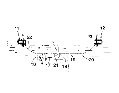
Figure 2 shows a detail view, from the side of a vertical longitudinal plane,
that is to say
perpendicularly to the surface of the expanse of water, of one of the seismic
cables, in this
case the cable 1, and its associated drones 11 and 12.
Cable 1 has sensor modules fixed to it, of which only the first three 13, 14
and 15 are
referenced, in the interests of clarity. There are, for example, 320 sensor
modules spaced
25 m apart.
Cable 1 also comprises elements forming a ballast container and referenced 16
to 20, and
intended to keep the cable at a constant submersion depth. Thus, the cable
includes a
main central portion 21 that is substantially rectilinear, supporting the
sensor modules and
ballast container elements, and two curved end portions 22 and 23 linking the
central
portion to each drone 11, 12.
The drones are of the type known per se, for example floating, or semi-
submersible with
propulsion, preferably diesel, or of the electrical type powered by a cable
linked to an
energy source on the main boat.
The drones comprise propulsion means (thruster) so as to keep the cable under
tension,
and more specifically so that the central portion 21, supporting the
hydrophones, is:
- substantially horizontal (see Figure 2), and
- positioned at a constant depth (using means specified later) between 20
and 200 m,
preferably between 50 and 100 m.
11
CA 02748906 2011-07-04
WO 2010/076646
PCT/1B2009/007908
The expression "depth of the cable" should be understood to mean the height of
water
situated above said rectilinear central portion 21.
The assembly formed by a cable and its sensors is designed to have a
substantially zero
buoyancy, that is to say that the average specific gravity of the cable is
substantially equal
to the specific gravity of the surrounding water, or slightly positive.
According to the invention, the cables 1 to 10 are kept:
- each under tension;
- in a given configuration; in the example of Figure 1, the cables are
parallel to one
another;
- stationary, either relative to the marine bottom or relative to the
marine environment,
or in a "pseudo-stationary" manner, to take account of the marine currents;
and
- at a given constant depth.
The drones can comprise absolute positioning means, of the GPS type. By using
known
triangulation means (of the acoustic type), it is possible to know the
relative position of
each sensor, and therefore from the GPS of the drones, the absolute position
of each
sensor.
Figure 3 diagrammatically represents, in plan view, the inventive device and
its operation
is described hereinbelow. The set of cables 1 to 10 as described previously is
put in place
according to a parallel cable configuration forming, for example, a square,
for a
measurement station. The cables are therefore parallel to one another, at a
constant and
equal distance of a few hundreds of meters, and are stationary, either
relative to the
marine bottom, or relative to the marine environment. In the latter case, they
are subject
only to the currents.
The assembly also comprises a main boat 24, including means of recording the
signals
originating from the seismic sensors, in other words hydrophones and
geophones, from
the position sensors, positioned on the cables and in the drones. The main
boat 24 can be
positioned at any point relative to the set of cables, but preferably on a
longitudinal axis
passing roughly through the middle of the geometrical figure, in this case a
square, formed
12
CA 02748906 2011-07-04
WO 2010/076646
PCT/1B2009/007908
by the set of cables. This preferred position close to a drone called pilot
also makes it
possible to optimize the radio transmissions of the seismic data. The main
boat 24 is
positioned in an approximately fixed manner relative to the set of cables
during the
measurements, then follows the movement of this set from one measurement
station to
another.
Also provided is a boat 25, supporting a seismic source, of the type known per
se and, for
example, an airgun. The source boat 25 moves, according to the preferred
embodiment of
Figure 3, offset relative to the set of cables, in a direction transversal to
that of the cables.
The set of cables is kept stationary for the time needed for the source boat
to typically
carry out a line of firings or a set of lines of firings represented in the
figure by asterisks.
The main boat 24 includes means of receiving the measurements and information
originating from the sensors in order to process said measurements.
The information originating from the sensors, both seismic and position
sensors, is first of
all stored temporarily in the drones, then transmitted in three possible ways
to the main
boat 24:
- either by electrical links, on the one hand by a cable and on the other
by a link, such
as that referenced 26 between the cables 1 and 2, and on the other hand
between
the cables Ito 10 and the main boat 24 (link 27);
- or by wireless link, such as a radio or other link, symbolized by the
arrows 28 and
29; in this solution, there are no wired links 26 between the seismic cables
and the
link 27, that is to say, between the seismic cables and the measurement boat
24;
- or by physical recovery of the disks or storage memories placed in the
drones, in
which case the radio link is used to transmit quality control information,
position
information that is small in volume, and commands in both directions.
According to a preferred embodiment, the main boat 24 can be linked to the
drones by
bidirectional radio links for the transmission of positioning data, seismic
and control data.
Each drone can thus communicate with the others, and with the source boat 25
and the
main boat 24 which records the data. As an example, the source boat and the
main boat
can then receive in real-time positioning information concerning the cables,
their sensors
and the drones. The source boat can then use this information in real time to
determine,
13
CA 02748906 2011-07-04
WO 2010/076646
PCT/1B2009/007908
based on the position of the cables, the frequency of firings from the source,
the direction
of the firing lines and the firing margins, relative to the real-time position
of the cables. The
drones can also be moved in real time according to current and/or firing
conditions.
Prior to the steps of firing from the source and measurements of the reflected
waves, the
cables are brought into position using one or more transport boats. The cables
equipped
with their sensors are wound on drums. When the transport boat arrives at the
first
measurement position, a drone, for example an upstream drone, is placed in the
water; the
end of a cable is attached to this drone using an attachment previously
installed on the
drone and the cable is unwound. The cable can either be pulled by the upstream
drone,
with the transport boat remaining immobile, or unwound due to the forward
movement of
the transport boat, the upstream drone then being immobile; when the cable is
completely
unwound, its other end is attached to another drone, in this case the
downstream drone.
The cable with its two drones is then freed from the boat. During this
manoeuvre involving
placing in the water, the upstream drone can receive information from a
central system, for
example, located on the main boat. This information enables it to position
itself, using its
GPS, in a precise position. The desired depth of the cable is obtained by
tensioning the
cable using the drones and by acting on appropriate means such as ballast
containers,
buoys and/or ballasts. The same procedure is applied to the other cables, with
them being
positioned relative to one another so as to obtain the desired configuration,
for example a
square, or any other desired geometrical shape.
The following steps, according to a preferred embodiment, are:
- the configuration shown in Figure 3 constitutes a measurement station, in
which the
elements of the latter, comprising the seismic cables, the source boat 25 and
the
measurement boat 24, are located at a given distance from one another and in a
given configuration;
- with the set of seismic cables and the main boat 24 being kept
stationary, the
source boat 25 begins a series of "firings" by periodic triggering of the
seismic
source, while moving along a line 29, perpendicular to the longitudinal
direction
(arrow F) of the seismic cables. The distance thus travelled by the source
boat 25,
moving away from the stationary set of seismic cables, is of the order of 16
km, for
a firing density of the order of 6 per minute, for a duration of approximately
2 hours;
14
CA 02748906 2011-07-04
WO 2010/076646
PCT/1B2009/007908
- the waves collected by the cables are picked up by the sensors, then the
corresponding signals are sent to the main boat 24 to be processed therein;
- then, the set is moved to another measurement station in the following
manner:
- the set of seismic cables 1 to 10 is moved parallel to itself, through
the
intermediary of the drones and their propulsion means, by a distance for
example of between 25 to 500 m, which corresponds to a "pitch" of movement
between two measurement stations;
- during this time, the main boat 24 moves in the longitudinal direction
(arrow F)
by the same distance or the same pitch;
- also during this time, the source boat 25 returns to the set of cables to
be
positioned on a new offset transversal line 30, distant from the preceding
line 29
by said pitch.
It will be noted that the movements of the cable or cables can take place on
each firing
from the source, but more often than not this will be after a succession of
firings has taken
place:
either a line of firings comprising, for example, 600 firings, according to a
method called
"progressive shooting", or even after a set of lines of firings, a blanket for
example,
according to a method called "patch" referring to a similar technique used in
an onshore
environment. In this case, the set of cables is kept stationary or pseudo-
stationary for the
entire time it takes for the source boat to fire a blanket or grid of firings
such as those
represented in Figure 3 by the lines of asterisks. Then, the whole of the
square or
rectangular configuration of cables is moved longitudinally by a length of the
device, or
transversely by a width of the latter, and the sequence of firings is repeated
in the same
way.
When a cable is positioned at a measurement point, it is tensioned using the
drones
attached to its two ends, the drones pulling the cable in opposite directions.
The traction
forces exerted by the two drones of one and the same cable and are not
necessarily equal
in absolute value since it is necessary to fight against the current. If we
consider, for a
given cable, the components of the forces exerted by the drones along the
longitudinal
axis formed by the intersection of a vertical plane passing through the cable
concerned
and the horizontal plane formed by the expanse of water, the forces being
counted
CA 02748906 2011-07-04
WO 2010/076646
PCT/1B2009/007908
positively in the direction of the longitudinal movement of the cable, that is
to say in the
downstream drone - upstream drone direction, the drone situated downstream,
that is to
say behind the cable in the direction of movement of the cable, exerts on the
cable a force
- Tõ (minimum cable tension) that is negative. The upstream drone exerts a
force
Tam = Tay + F in which F is the hydrodynamic drag of the cable in the current.
In the
absence of currents, or if the cables are allowed to drift, the forces Ta, and
Tam are equal
and opposite (since F = 0).
Another variant implementation of the inventive method consists in moving the
source boat
25 along a line parallel to the cables (arrow F). This variant is less
preferred than that in
which the source boat moves perpendicularly to the cables, which provides
isotropic
measurements and a smaller seismic pixel size, also called "bin", for example
measuring
12.5 m x 12.5 m, making the measurements more accurate.
Figure 4 shows a variant embodiment, compared to Figure 2, of a seismic cable
and its
two associated drones, in the form of semi-submersible drones.
The cable is kept at a constant depth by means described hereinbelow.
According to a first
example, ballast containers 16 to 20 are used, one example of which is shown
in
Figures 5A and 5B according to two cross-sectional diagrammatic views of a
ballast
container, comprising an actuator 37, a box 38 inside which there is a bellows
39.
Depending on the compressed or expanded state of the bellows, the water fills
the box or
is discharged from the latter.
According to a second example, shown in Figure 6, the means of keeping a cable
50
constant at a given depth include thrusters 51 of known type. Each thruster
comprises
three tubes 52, 53 and 54 arranged at 120 radially around the cable 50.
Within each tube
there is a propeller, respectively 55, 56 and 57, associated with a motor. To
compensate
the effects of rotation of the cable on itself, inclinometers are provided
that make it
possible to gain a thrust reference on the thrusters when vertical. These
thrusters can also
be used to keep the separation between the cables constant, compensating or
assisting
the drones in this respect. The cable 50 is surrounded by a frame 58 of
cylindrical form,
linked to the cable 50 by spacers 59. A space 60 situated between the cable 50
and the
frame 58 allows water to circulate around the cable 50.
16
CA 02748906 2011-07-04
WO 2010/076646 PCT/1B2009/007908
Figure 7 shows yet another variant embodiment, with drones identical to those
of Figure 4,
the seismic cable being associated with:
- ballasts, of which only two, referenced 31 and 32, are indicated in the
figure;
- buoys, of which only two, referenced 33 and 34, are shown in the figure,
positioned
every 200 to 400 meters in the longitudinal direction of the seismic cable;
each buoy
is linked to the cable by a wired link, respectively 35 and 36.
This embodiment, as illustrated in Figure 7, is adapted to the variant of the
method in
which the set of cables is kept stationary relative to the aquatic medium,
that is to say,
drifts according to the local current.
It is also ideal for the case where the cable is kept "pseudo-stationary"
relative to the
bottom. For example, for a current of 1 knot, the cables are self aligned in
the direction of
the current.
One of the "upstream drones", i.e. those pointing in the direction of the
current, constitutes
a fixed point and produces what is called a "pseudo-dynamic" positioning of
the set of
cables relative to a given absolute position. The "upstream drones" of the
other cables are
positioned according to the dual setpoint:
- upstream line of drones perpendicular to the cables (in the case of a
square or
rectangular configuration);
- given constant separation of the upstream drones.
The device is provided with means making it possible to retain the
configuration of the
cables according to the variations of the current, e.g. direction, intensity.
In case of
reversal of the current, the upstream and downstream drones swap their
functions, and in
this case in point, the drones are therefore identical in terms of their
functionalities.
Figures 8A to 8E schematically show different link possibilities between the
cable 1 and
each sensor module, in order to enable the sensor modules to be mechanically
separated.
Figure 8A shows the box 40 comprising the sensors, and linked to the cable by
right and
left connectors 41 and 42; the box 40 can also be linked to the cable in a
fixed manner.
17
CA 02748906 2011-07-04
WO 2010/076646
PCT/1B2009/007908
Figures 8B and 8C show a common variant in which the box of sensors is not
fixed directly
to the cable, in order to reduce the noise and avoid the possible measurement
artefacts
generated by the presence, and the vibrations, of the cable. The box of
sensors is linked to
the cable by a tap line, or "take-out", of a few meters via a connector 43
located on the
cable (Figure 8B) or by a connector 44 located on the box of sensors (Figure
8C).
Figure 8D shows the variant of Figure 8C, also showing the buoy fixing system,
according
to the option shown in Figure 7.
Figure 8E shows a variant that is preferred over that of Figure 8D, in which
two sensor
boxes 45 and 46, including hydrophones only, are attached to the cable by
flexible links,
for example approximately 3 m long, on either side of the cable, in the
vertical direction.
Finally, Figure 9 is a diagram of another exemplary configuration of the
cables, in this case
a star configuration, that can be produced only in the stationary mode
relative to the
aquatic environment. Other configurations are possible: diamond, trapezium,
rectangle,
etc.
The whole of the device is preferably managed by a central logic system, such
as a
programmed computer, placed in the main boat and managing, for example,
acquisition of
the seismic data, driving of the drones for their positioning and actuation of
the source. A
central intelligence, in the form of real-time software, manages and
coordinates the
navigation commands in order to obtain the best stationarity and the desired
cable
geometry, throughout the series of measurements. This software can take
account of the
sea currents. For this, the current speed and orientation values are not only
measured
locally, or compiled in existing publications, but also predicted over a
period of a few days,
by using oceanographic and/or meteorological services, and existing models,
then
recorded in a database of the central computer.
The inventive method and device offer the following advantages:
- using hydrophones and geophones makes it possible, by combining signals
originating from the two types of sensors, to obtain a "flat spectrum",
eliminate
"ghosts" and collect information relating to very low frequencies and
determine the
direction of the waves, for example, to separate noise originating from other
seismic
boats;
18
CA 02748906 2011-07-04
WO 2010/076646 PCT/1B2009/007908
- the seismic cable is subject to a low tension compared to the tension of
the prior art
in which the cable is towed at a speed of several knots; consequently, the
noise
level due to towing is greatly reduced, notably for the geophones and the
accelerometers;
- in the variant in which the cable is stationary relative to the aquatic
bottom, it is
moved at a speed that is the inverse of that of the current, of the order of 1
knot on
average, that remains low compared to the speeds of movement of the
conventional methods. The flow noise that affects all the seismic sensors is
therefore considerably reduced, or even zero in the absence of currents.
Furthermore, when the cable is submerged at a great depth, for example greater
than 50 m, this arrangement makes it possible to greatly reduce the noise
levels, by
approximately a half or a quarter, compared to the methods of the prior art,
in which
the cable is pulled at a speed of 5 knots, and at a shallow depth of the order
of 6 m.
The inventive method means that the signal is almost insensitive to the noise
of the
waves and the condition of the sea;
- since the signal/noise ratio is significantly enhanced, the inventive
device requires
only a single source that is two to four times less powerful than that used
normally,
with the resulting savings;
- the inventive device allows for a wide variety of geometrical cable
configurations,
notably very wide configurations, called "wide azimuth", or very long
configurations,
as indicated previously. It is thus possible to adapt the configuration to the
type of
prospecting carried out, and more specifically to the complex and deep
geological
structures being investigated, such as, for example, salt domes, faults,
overlaps and
basaltic layers;
- this same configuration versatility enables the inventive device to
circumvent
obstacles, such as small islands or oil platforms, while continuing with the
measurement. In practice, assuming a "square" configuration, it is possible to
envisage separating the cables into two sets, one portion passing to the left
of the
obstacle, while the other portion passes to the right;
- the invention allows for accurate measurements thanks to the reduced size
and the
isotropy of the "bin" or seismic pixel, of the order of 12.5 m x 12.5 m, which
makes it
possible to improve the effectiveness of the seismic processing and notably
the
application, for example, of anti-multiples or anti-noises or imaging;
19
CA 02748906 2011-07-04
WO 2010/076646 PCT/1B2009/007908
- the inventive method requires only one measurement boat of reduced power
compared to the prior art, since the latter does not tow the set of cables;
- the inventive device involves only a single source boat; however, it is
possible to
make use of techniques known as simultaneous firings that can be used with
airguns, or with vibratory marine sources, and thus by using several source
boats,
productivity then being that much more improved;
- it can be estimated that the cost of using the inventive device is of the
order of 35%
less than the "wide azimuth" techniques described previously, and that the
productivity is multiplied by a factor of 2 to 4 compared to the seabed cable
laying
techniques.