Note: Descriptions are shown in the official language in which they were submitted.
CA 02749880 2011-07-15
WO 2010/085400 PCT/US2010/020843
GEOSPATIAL MODELING SYSTEM FOR 3D CLUTTER DATA AND
RELATED METHODS
The present invention relates to the field of geospatial modeling, and,
more particularly, to geospatial modeling of digital surface models and
related
methods.
Topographical models of geographical areas may be used for many
applications. For example, topographical models may be used in flight
simulators and
other planning missions. Furthermore, topographical models of man-made
structures,
for example, cities, may be extremely helpful in applications, such as,
cellular antenna
placement, urban planning, disaster preparedness and analysis, and mapping.
Various types of topographical models are presently being used. One
common topographical model is a digital elevation model (DEM). The DEM is a
sampled matrix representation of a geographical area, which may be generated
in an
automated fashion by a computer. In the DEM, coordinate points are made to
correspond with a height value. DEMs are typically used for modeling terrain
where
the transitions between different elevations, for example, valleys, mountains,
are
generally smooth from one to a next. That is, a basic DEM typically models
terrain as
a plurality of curved surfaces and any discontinuities therebetween are thus
"smoothed" over. Another common topographical model is a digital surface model
(DSM). The DSM is similar the DEM but may be considered as further including
details regarding buildings, vegetation, and roads, in addition to information
relating
to terrain.
U.S. Patent No. 6,654,690 to Rahmes et al., which is assigned to the
assignee of the present application, and is hereby incorporated herein in its
entirety by
reference, discloses an automated method for making a topographical model of
an
area including terrain and buildings thereon based upon randomly spaced data
of
elevation versus position. The method includes processing the randomly spaced
data
to generate gridded data of elevation versus position conforming to a
predetermined
position grid, processing the gridded data to distinguish building data from
terrain
-1-
CA 02749880 2011-07-15
WO 2010/085400 PCT/US2010/020843
data, and performing polygon extraction for the building data to make the
topographical model of the area including terrain and buildings thereon.
In certain planning applications, for example, wireless communication
system deployment, data describing the ground occupancy above the terrain is
used,
i.e., clutter data. In these applications, the clutter data is typically used
for radio
frequency propagation analysis. The clutter data is typically organized in a
plurality
of classes, for example, dense trees, sparse trees, agriculture, industrial,
urban, and
dense urban. Each of the classes of clutter data has corresponding propagation
information, such as, height, diffraction factor, and absorption.
Typical clutter data includes two-dimensional (2D) heights, which may
result in non-optimal analysis. There are some disclosed methods for inserting
three-
dimensional (3D) height data into 2D clutter data. For example, the 3D height
data
may be collected in the field, or the clutter objects in large models may be
manually
attributed with 3D data. These approaches may be time consuming and tedious.
More specifically, this type of 3D rendering for 2D clutter objects may be
lengthy and
expensive since the modeler renders the object in 3D, locates the clutter
areas, and
determines where the rendered object correlates in the 2D space.
For example, U.S. Patent No. 7,298,316 to Tsai et al. discloses a
device for detecting clutter blocks and an interference source for dynamically
establishing a 2D clutter map. The device may include a clutter block
detecting
module for accumulating a plurality of range cell data of each detecting area
and for
comparing the accumulated value with a clutter block level to define the
position of a
clutter block. The device may also include an interference source detecting
module
for accumulating all range cell data in each radar beam area and for comparing
the
accumulated value with an interference source reference level to detect
whether any
interference source exists. The device also includes a clutter map
establishing module
for saving the clutter maps on different beam areas in three memory blocks.
In view of the foregoing background, it is therefore an object of the
present invention to provide a geospatial modeling system for providing
accurate
three-dimensional (3D) clutter information.
-2-
CA 02749880 2011-07-15
WO 2010/085400 PCT/US2010/020843
This and other objects, features, and advantages in accordance with the
present invention are provided by a geospatial modeling system comprising a
geospatial model database having stored therein an initial 3D digital surface
model
(DSM) of a geographical area, and a plurality of two-dimensional (2D) clutter
data
files for respective different types of possible non-building clutter. The
geospatial
modeling system may also include a processor cooperating with the geospatial
model
database to generate an updated DSM including therein 3D clutter data based
upon
the initial DSM and the 2D clutter data files. Advantageously, the geospatial
modeling system readily provides 3D clutter data with the DSM.
In some embodiments, the processor may further cooperate with the
geospatial model database to generate the updated DSM including therein 3D
clutter
data by at least generating a bare earth digital terrain model (DTM) from the
initial
DSM, and combining the 2D clutter data files with the bare earth DTM.
Moreover,
the processor may further generate height histogram data and combine the 2D
clutter
data files with the bare earth DTM using the height histogram data.
More specifically, the geospatial model database may store the 2D
clutter data files comprising 2D clutter data files associated with at least
one of trees,
agriculture, industrial development, and urban development. Also, the
geospatial
model database may store the 2D clutter data files with each of the 2D clutter
data
files comprising a number of vertices. The 3D clutter data may have a desired
detail
value based upon the number of vertices. The processor may further cooperate
with
the geospatial model database to generate the updated DSM including therein 3D
clutter data having at least one of a minimum height value, a maximum height
value,
a mean height value, a standard deviation value, a base height value, an area
value, a
slope value, a width value, and a length value.
In some embodiments, the geospatial modeling system may further
comprise a display coupled to the geospatial model database and the processor
to
display the updated DSM. The processor may further cooperate with the
geospatial
model database to generate the initial DSM using image correlation on aerial
earth
images.
-3-
CA 02749880 2011-07-15
WO 2010/085400 PCT/US2010/020843
Another aspect is directed to a computer implemented method for
modeling an initial 3D DSM of a geographical area and a plurality of 2D
clutter data
files for respective different types of possible non-building clutter. The
computer
implemented method may include generating an updated DSM including therein 3D
clutter data based upon the initial DSM and the 2D clutter data files.
FIG. IA is a schematic diagram of a geospatial modeling system
according to the present invention.
FIG. lB is a more detailed schematic diagram of the geospatial
modeling system of FIG 1A.
FIG. 2 is a flowchart illustrating a computer implemented method for
geospatial modeling according to the present invention.
FIG. 3 is a computer display screen print image of a 2D clutter map for
input into the geospatial modeling system of FIGS. IA and 113.
FIG. 4 is a computer display screen print image of an updated DSM
produced by the geospatial modeling system of FIGS. IA and 113.
FIG. 5 is an enlarged portion of the computer display screen print
image of FIG. 4.
FIG. 6 is a more detailed version of the computer display screen print
image of FIG. 5.
FIG. 7 is a yet further enlarged portion of the computer display screen
print image of FIG. 5 with coniferous 3D clutter data highlighted.
FIG. 8 is a computer display screen print image of an initial DSM for
input into the geospatial modeling system of FIGS. IA and 113.
FIG. 9 is a schematic block diagram of a geospatial modeling system
according to the present invention.
The present invention will now be described more fully hereinafter
with reference to the accompanying drawings, in which preferred embodiments of
the
invention are shown. This invention may, however, be embodied in many
different
forms and should not be construed as limited to the embodiments set forth
herein.
Rather, these embodiments are provided so that this disclosure will be
thorough and
-4-
CA 02749880 2011-07-15
WO 2010/085400 PCT/US2010/020843
complete, and will fully convey the scope of the invention to those skilled in
the art.
Like numbers refer to like elements throughout.
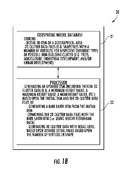
Referring initially to FIGS. IA, 1B, and 2, a geospatial modeling
system 20 according to the present invention is now described. Moreover, with
reference to the flowchart 30 of FIG. 2, another aspect directed to a computer
implemented method for geospatial modeling is also now described, which begins
at
Block 31. The geospatial modeling system 20 illustratively includes a
geospatial
model database 21, a processor 22, illustrated as a personal computer (FIG.
IA),
coupled thereto, and a display 23 also coupled to the processor 22. By way of
example, the processor 22 may be a central processing unit (CPU) of a PC, Mac,
or
other computing workstation.
The geospatial model database 21 illustratively stores at Block 33 an
initial three-dimensional (3D) digital surface model (DSM) of a geographical
area,
and a plurality of two-dimensional (2D) clutter data files for respective
different types
of possible non-building clutter. As will be appreciated by those skilled in
the art, the
2D clutter data files comprise at least land use clutter data and land cover
clutter data.
For example, the 2D clutter data files may comprise shapefiles. In
certain embodiments, the geospatial modeling database 21 may generate the
initial
DSM using image correlation on aerial earth images, for example. In yet other
embodiments, the processor 22 may generate the initial DSM using the method
disclosed in U.S. Patent Application Publication No. 2007/0265781 to Nemethy
et al.,
also assigned to the assignee of the present invention, and the entire
contents of which
are incorporated by reference herein.
At Block 35, the processor 22 further illustratively cooperates with the
geospatial model database 21 for generating a bare earth digital terrain model
(DTM)
from the initial DSM, and combining at Block 37 the 2D clutter data files with
the
bare earth DTM. Once the processor 22 has combined the 2D clutter files with
the
bare earth DTM, the processor illustratively cooperates with the geospatial
model
database 21 for generating an updated DSM including therein 3D clutter data
based
upon the initial DSM and the 2D clutter data files. (Block 39).
Advantageously, the
-5-
CA 02749880 2011-07-15
WO 2010/085400 PCT/US2010/020843
geospatial modeling system 20 automatically provides quick and accessible 3D
clutter
data without the cumbersomeness and cost of typical methods.
The geospatial modeling system 20 may provide the updated DSM
with 3D clutter data on the display 23 for advantageous viewing by the user.
In
certain embodiments, the processor 22 may further generate height histogram
data and
combine the 2D clutter data files with the bare earth DTM using the height
histogram
data. More specifically, statistical histogram analysis is used to determine
the best
clutter object height based on all the height post values within the boundary
of the
given object, as will be appreciated by those skilled in the art. The method
ends at
Block 41.
Optionally and as will be appreciated by those skilled in the art, the
geospatial model database 21 may store the 2D clutter data files comprising 2D
clutter
data files associated with at least one of trees, agriculture, industrial
development,
urban development, dense urban, light urban, urban residential, suburban
residential,
paved areas, native forest dense, native forest medium, exotic forest dense,
exotic
forest medium, scrub, open areas, wetland, ice and snow, and water.
Also, in embodiments where the 2D clutter data files comprise
shapefiles, the geospatial model database 21 may store the shape files with
each
having a number of vertices, i.e., the 2D clutter data files may have a
certain level of
detail. Based upon the this level of detail in the shapefiles, the geospatial
modeling
system 20 sets the desired level of detail for the 3D clutter data.
For example, the processor 22 may further cooperate with the
geospatial model database 21 for generating the updated DSM including therein
3D
clutter data having at least one of a minimum height value, a maximum height
value,
a mean height value, a standard deviation value, a base height value, an area
value, a
slope value, a width value, and a length value.
Referring now additionally to FIGS. 3-5, an image 50 (FIG. 3)
illustrates an exemplary 2D image with 2D clutter data files for input into
the
geospatial modeling system 20. Once the image 50 is processed, an image 60
(FIG.
4) of the updated DSM counterpart is provided by the geospatial modeling
system 20.
-6-
CA 02749880 2011-07-15
WO 2010/085400 PCT/US2010/020843
Another image 70 (FIG. 5) illustrates an enlarged portion of the updated DSM
image
60.
Referring now additionally to FIGS. 6-8, an image 80 (FIG. 6)
illustratively includes a context menu 81 highlighting types 82-84 of 3D
clutter data,
which corresponds to 2D shapefiles, in the updated DSM. The context menu 81
illustratively includes data relating to feature identification number (FID),
shape
(polygon, line, point), layer (classification, illustrated here as unknown
area type),
elevation (height in meters), 3D area (length multiplied by width), 3D length
(measured in meters), 3D width (measured in meters), 3D height (measured in
meters
above WGS84 Ellipsoid), 2D height (measured in meters above WGS84 Ellipsoid),
and SSR (shape of roof - flat, pitched, or complex). Yet another image 90
(FIG. 7)
shows an enlarged portion of the updated DSM image 80 where one 82 of the
types
82-84 of 3D clutter data is noted as a coniferous layer with a height of 4.7
meters.
Another image 100 (FIG. 8) shows a detailed DSM for input into the geospatial
modeling system 20.
Referring now to FIG. 9, as will be appreciated by those skilled in the
art, an exemplary implementation 110 of the geospatial modeling system 20
described
above is now described. The exemplary geospatial modeling system 110
illustratively
includes an ingest module 111 for ingesting optical image stereo pairs, for
example,
and a 2D clutter module 114 downstream from the ingest module for receiving an
output of the ingest module. The exemplary geospatial modeling system 110 also
illustratively includes an initial DSM module 112, also receiving the output
of the
ingest module 111, and for creating an initial DSM. The exemplary geospatial
modeling system 110 illustratively includes a DTM module 113 for extracting a
bare
earth DTM from the initial DSM, and a 3D clutter module 115 for generating an
updated DSM including therein 3D clutter data based upon the initial DSM and
the
2D clutter data files. The 3D clutter module 115 receives outputs from the DTM
module 113, the initial DSM module 112, and the 2D clutter module 114, and
outputs
to the output module 116, which as will be appreciated by those skilled in the
art, may
be used for other applications.
-7-