Note: Descriptions are shown in the official language in which they were submitted.
CA 02753946 2011-08-26
WO 2010/102097 PCT/US2010/026193
TITLE: THREE-DIMENSIONAL VISUALIZATION OF IMAGES
IN THE EARTH'S SUBSURFACE
FIELD OF THE INVENTION
[0001] The present invention generally relates to the field of computer
graphics, and more
particularly, to a system, method and memory medium for visualizing images in
a three-dimensional
context.
DESCRIPTION OF THE RELATED ART
[0002] The art of computer graphics has developed to the point where complex
three-dimensional
scenes can be created and visualized using software tools. However, for
geoscientists and those
interested in exploring the earth's subsurface for features of interest or
economic value, such tools
may be difficult to use. Thus, there exists a need for tools more particularly
suited to the
visualization of the earth's subsurface.
SUMMARY
[0003] In one set of embodiments, a method for visualizing one or more images
in a three-
dimensional (3D) environment may include the following operations.
[0004] The method may include displaying a 2D map window using a display
system. The 2D map
window represents a given portion of the earth's surface according to a given
cartographic reference
system (or map projection system). The cartographic reference system being
used may be
determined by user selection. Similarly, the portion of the earth's surface
that is being displayed
may be determined by user selection.
[0005] The method may also include receiving user input specifying a plurality
(or sequence) of
points in the 2D map window. The plurality of points defines a polyline. Thus,
the plurality of
points includes two end points and zero or more knee points. Alternatively,
the user may specify the
plurality of points by means other than specifying them in the 2D map window.
For example, the
user may specify the points by entering their coordinate values via an input
dialog, or simply by
identifying a previously generated list of points stored in memory.
[0006] The method may also include receiving user input specifying a vertical
range in a vertical
dimension. The vertical dimension may be interpreted as extending
perpendicular to the given
portion of the earth's surface.
[0007] The method may also include receiving user input identifying an image
that is stored in a
memory. The content of the image and the means of producing the image are not
constrained by the
present invention. Furthermore, image is not limited to a specific file
format.
[0008] The method may also include generating a set of geometry data based on
the polyline and the
vertical range, where the geometry data set represents a folded rectangle in
three-dimensional space.
CA 02753946 2011-08-26
WO 2010/102097 PCT/US2010/026193
The folded rectangle has one fold for each knee point in the polyline. In the
case where the polyline
has no knee points, the folded rectangle is simply a rectangle with no folds.
[0009] The 2D map window may represent a horizontal plane of projection. Thus,
the polyline may
be interpreted geometrically as the projection of the folded plane onto the
horizontal plane.
Similarly, the vertical range may be interpreted geometrically as the
projection of the folded plane
onto the vertical dimension.
[0010] The method may also include adding the geometry data set to a 3D
virtual world (e.g., a
scene graph), and adding a copy of the image to the 3D virtual world. The
operation of adding the
image copy to the 3D virtual world may include specifying that the image copy
is to be applied as
texture to the geometry data set. (The 3D virtual world is a data structure
that contains data objects
used to define the 3D environment.)
[0011] The method may also include rendering the 3D virtual world to obtain a
rendered image. The
action of rendering the 3D virtual world includes rendering the geometry data
set using the image
copy as texture.
[0012] The method may also include displaying the rendered image in a 3D
window using the
display system. When displayed, the rendered image visually represents
(depicts) the image as being
painted onto the folded rectangle in the three-dimensional space.
[0013] In various embodiments, the method may also allow the user to add
additional image-painted
folded rectangles to the three-dimensional space. The image-painted folded
rectangles may have any
desired configurations in the three-dimensional space. For example, they may
freely intersect each
other.
[0014] In various embodiments, the method may also allow the user to "move
around" (navigate) in
the 3D world.
[0015] In some embodiments, the 3D virtual world may include one or more other
types of graphical
object. Thus, the rendered image obtained by the rendering action may include
visual representation
of the other types of graphical objects. For example, the 3D virtual world may
include: objects
representing one or more reservoir models; objects representing one or more
subsurface horizons;
objects representing one or more seismic profiles; objects representing the
three-dimensional
trajectory of wells in the earth's subsurface; or any combination thereof.
[0016] In some embodiments, a computer-accessible memory medium that stores
program
instructions is contemplated. The program instructions are executable by a
computer system to
implement a method, e.g., any of the method embodiments described herein, or,
any combination of
the method embodiments described herein, or, any subset of any method
embodiment described
herein.
2
CA 02753946 2011-08-26
WO 2010/102097 PCT/US2010/026193
[0017] In some embodiments, a computer system is configured to include a
processor (or a set of
processors) and memory medium. The memory medium stores program instructions.
The processor
is configured to read and execute the program instructions. The program
instructions are executable
to implement a method, e.g., any of the various method embodiments described
herein, or, any
combination of the method embodiments described herein, or, any subset of the
method
embodiments described herein. The computer system may be realized in any of
various forms.
[0018] Various embodiments described herein allow a user (or a set of users)
to view images in a
three-dimensional context, i.e., painted onto folded rectangles arranged in a
three-dimensional space.
This viewing capability may allow the user to make more informed
interpretations and decisions
regarding features and/or structures in the images. For example, a user may
use the visualizations
described herein to make decisions regarding where to drill a set of one or
more wells, where to
perforate a well, how many wells to drill in a given reservoir; to estimate a
production capacity of a
reservoir; to estimate the cost or difficulty of exploiting a given deposit of
a substance such as oil,
gas, ore or coal; etc.
Brief Description of the Drawings
[0019] Figure IA illustrates one embodiment of a method for visualizing an
image in a 3D context.
[0020] Figure 1B illustrates one example of an image being painted onto a
folded rectangle in a
three-dimensional space.
[0021] Figure 1C illustrates another example of an image being painted onto a
folded rectangle in
the three-dimensional space.
[0022] Figure 2 illustrates one embodiment of a computer system that may be
used to execute
program instructions.
[0023] Figure 3A illustrates one embodiment of a method for adding a second
folded rectangle to the
three-dimensional space.
[0024] Figure 3B illustrates an example of two folded rectangles intersecting
in the three-
dimensional space.
[0025] Figure 4A illustrates one embodiment of a method for modifying the
spatial configuration of
a folded rectangle in the 3D space.
[0026] Figure 4B illustrates an example of a folded rectangle being modified
by means of moving a
knee point in the corresponding polyline.
[0027] Figure 5A illustrates one embodiment of a method for translating a
folded rectangle in the 3D
space by moving the corresponding polyline in the window W2.
[0028] Figure 5B illustrates an example of the translation of a folded
rectangle F1 by moving its
corresponding polyline P1 in the window W2.
3
CA 02753946 2011-08-26
WO 2010/102097 PCT/US2010/026193
[0029] Figure 6A illustrates one embodiment of a method for adding structure
to a folded rectangle
in the 3D space by specifying the addition of a point to the corresponding
polyline.
[0030] Figure 6B illustrates an example of the addition of another face to an
object in the three-
dimensional space by adding another point to the corresponding polyline.
[0031] Figure 7 illustrates one embodiment of a method for moving a view point
in the 3D space.
[0032] Figure 8 illustrates one embodiment of a method for changing a view
direction in the 3D
space.
[0033] Figure 9A illustrates an example of adjusting the view point and view
direction to achieve the
effect of "walking around" the 3D environment.
to [0034] Figure 9B illustrates one embodiment of a method for
simultaneously adjusting the view
point and view direction based on a user-specified rotation.
[0035] Figure 10A illustrates one embodiment of a method for highlighting a
point on a polyline in
the window W1 based on a current cursor position in the window W2.
[0036] Figure 10B illustrates an example of the cursor position Xc on the
folded rectangle F1 in the
window W2.
[0037] Figure 10C illustrates an example of the ray defined by the current
view point and the current
cursor position; the point Q on the folded rectangle F1 that is hit by the
ray; and the corresponding
point in the window W3 (highlighted with cross hairs).
[0038] Figure 11 illustrates one embodiment of a method for displaying
coordinate frame
information.
[0039] Figure 12A illustrates one embodiment of a method for generating a
"flattened" visualization
of a folded rectangle of the three dimensional space.
[0040] Figure 12B illustrates an example of the "flattened" visualization
(also referred to herein as a
"2D section view") in window W3.
[0041] Figure 13A illustrates one embodiment of a method for drawing, writing
or typing on a
folded rectangle in the 3D space.
[0042] Figure 13B illustrates an example of drawing a horizontal line in the
image of window W3
and having that drawing appear on the folded rectangle F1.
[0043] Figure 14A illustrates one embodiment of a method for adding a
spatially-localized note to
the surface on an object such as one of the folded rectangles in the 3D space.
[0044] Figure 14B illustrates an example of a graphical indicator 1472 being
injected onto the folded
rectangle F1 to indicate the presence of a spatially-localized note.
[0045] Figure 15 illustrates one embodiment of a method for animating a given
one of the folded
rectangle in the 3D space, i.e., animating with a series of images.
4
CA 02753946 2013-12-12
=
[0046] Figure 16 illustrates multiple views of a vertically georeferenced
raster image according to
one embodiment.
[0047] While the invention is susceptible to various modifications and
alternative forms, specific
embodiments thereof are shown by way of example in the drawings and are herein
described in
detail. It should be understood, however, that the the scope of the claims
should not be limited by the
preferred embodiments set forth in the examples, but should be given the
broadest interpretation
consistent with the description as a whole
Detailed Description of the Embodiments
[0048] The present invention may be realized in any of various forms. For
example, in some
embodiments, the present invention may be realized as a computer-implemented
method, a
computer-accessible memory medium, or a computer system. In other embodiments,
the present
invention may be realized using one or more custom designed hardware devices
such as ASICs or
FPGA' s.
[0049] A memory medium is a medium configured for the storage and retrieval of
information.
Examples of memory media include: various kinds of semiconductor memory such
as RAM and
ROM; various kinds of magnetic media such as magnetic disk, tape, strip, and
film; various kinds of
optical media such as CD-ROM and DVD-ROM; various media based on the storage
of electrical
charge and/or other physical quantities; media fabricated using various
lithographic techniques; etc.
[0050] A computer-accessible memory medium is a memory medium that stores
program
instructions and/or data, where the program instructions are executable by a
computer system to
implement a method, e.g., any of a method embodiments described herein, or,
any combination of
the method embodiments described herein, or, any subset of any of the method
embodiments
described herein.
[0051] In some embodiments, a computer system may be configured to include a
processor (or a set
of processors) and a memory medium. The memory medium stores program
instructions. The
processor is configured to read and execute the program instructions. The
program instructions are
executable to implement any of the various method embodiments described herein
(or, any
combination of the method embodiments described herein, or, any subset of any
of the method
embodiments described herein). The computer system may be realized in any of
various forms. For
example, the computer system may be a personal computer (in any of its various
realizations), a
workstation, a computer on a card, a server computer, a client computer, a
hand-held device, etc.
5
CA 02753946 2011-08-26
WO 2010/102097 PCT/US2010/026193
[0052] In some embodiments, a set of computers distributed through a network
may be configured to
partition the effort of executing a computational method (e.g., any of the
method embodiments
disclosed herein).
[0053] In one embodiment, a computer-implemented method 100 for
visualizing one or more
images in a three-dimensional (3D) environment may involve the following
operations which are
described in connection with Figures 1A-1C.
[0054] At 110, a computer system (or a set of computer systems) may display a
window W1 using a
display system. The window W1 represents a given portion of the earth's
surface according to a
given cartographic reference system (or map projection system). The window W1
may be configured
to to allow certain kinds of drawing input as described below. The term
"window" has the full breadth
of its ordinary meaning, and refers to a portion or all of a display screen
for displaying content, such
as an image, text, etc. A window may be a graphical user interface (GUI)
element for receiving user
input and/or displaying output.
[0055] As used herein the term "earth's surface" refers to the entire surface
of the planet earth,
including both land surface and sea/ocean/aquatic surface.
[0056] The user may choose the cartographic reference system being used from a
set of supported
cartographic reference systems. The set of supported reference systems may
include reference
systems that are of interest in the fields of oil and gas exploration. For
example, in one embodiment,
the following cartographic reference systems are supported: WGS 84, EPSG 4326,
and any of the
UTM zones.
[0057] Furthermore, the user may select the portion of the earth's surface
that is being
examined/visualized.
[0058] At 120, the computer system may receive user input specifying a
plurality (or list) of points
in the window WI, where the plurality of points defines a polyline P1. (A
polyline is a sequence of
line segments that are connected to form a path.) The plurality of points
includes two end points and
zero or more knee points. A knee point is an intermediate point, i.e., a point
that is not one of the
end points. The polyline P1 illustrated in Figure 1B has two knee points. The
polyline P1 shown in
Figure 1C has one knee point. In the case where the polyline includes zero
knee points, the polyline
is simply a line segment.
[0059] The user may specify the plurality of points by performing mouse-based
manipulations in the
window W1, e.g., manipulations such as mouse click and drag operations.
[0060] Alternatively, the user may specify (or identify) the plurality of
points by means other than
specifying them in the window WI. For example, in one input mode, the user may
specify the
plurality of points by entering the coordinates of the points in the given
cartographic reference
6
CA 02753946 2011-08-26
WO 2010/102097 PCT/US2010/026193
system, e.g., by means of keyboard entries in an input dialog. In another
input mode, the user may
identify a list of points that have already been stored in memory.
[0061] At 130, the computer system may receive user input specifying a
vertical range R1 in a
vertical dimension that extends perpendicular to the given portion of the
earth's surface. The range
Ri is an interval [A,B] along the vertical dimension. The user may specify the
range R1 by any of
various means. For example, the user may mark the interval bounding values A
and B by clicking on
desired positions of a displayed line segment (or bar) representing the
vertical dimension. As
another example, the user may enter the values A and B through numeric input
fields in a graphical
user interface (e.g., a displayed input dialog). As yet another example, the
user may enter the values
A and 6=B-A, i.e., a start value and interval length.
[0062] The computer system may allow the user to select the physical variable
that is to be
associated with the vertical dimension. For example, in one embodiment, the
user may select the
vertical dimension to be depth or time. The choice of depth may be useful when
attempting visualize
physical structure under the earth. The choice of time may be useful when
visualizing data objects
with a vertical component measured in two-way travel time e.g. seismic data
[0063] At 140, the computer system may receive user input identifying an image
Ii that is stored in a
memory (e.g., in the computer's RAM or on magnetic disc or a server over a
network). The content
of the image I and the means of producing the image are not constrained by the
present invention.
Furthermore, the image is not limited any specific format. In one embodiment,
any of the following
image extensions may be used: JPEG = "jpeg", JPG = "jpg", GIF = "gif', TIFF =
"tiff', TIF = "tif',
PNG = "png", BMP = "bmp" and PNM = "pnm".
[0064] At 150, the computer system may generate a set S1 of geometry data
based on the polyline P1
and the vertical range R1, where the set S1 of geometry data represents a
folded rectangle F1 in three-
dimensional space. The folded rectangle F1 has one fold for each knee point in
the polyline P1. In
the case where the polyline P1 has no knee points, the folded rectangle F] is
simply a rectangle with
no folds.
[0065] The window W2 may represent a horizontal plane of projection. Thus, the
polyline P] may be
interpreted geometrically as the projection of the folded plane F] onto the
horizontal plane.
Similarly, the vertical range R1 may be interpreted geometrically as the
projection of the folded plane
onto the vertical dimension.
[0066] In one embodiment, the geometry data set S1 may include a triangle mesh
(or a mesh of
polygons). The geometry data set S1 may also include a TriangleSet and/or a
QuadSet.
[0067] At 160, the computer system may add the geometry data set Si to a 3D
virtual world. The 3D
virtual world is a data structure that contains data objects used to define a
3D environment, e.g., data
7
CA 02753946 2011-08-26
WO 2010/102097 PCT/US2010/026193
objects such as sets of geometry data, textures, transformations and lights.
In one embodiment, the
3D virtual world is organized as a tree structure, e.g., as a scene graph or a
portion of a scene graph.
[0068] At 170, the computer system may add a copy of the image II to the 3D
virtual world. The
operation of adding the image copy to the 3D virtual world may include
specifying that the image
copy is to be applied as texture to the geometry data set S1. Thus, the image
copy may be
"coincident" with the geometry data Si.
[0069] At 180, the computer system may render the 3D virtual world to obtain a
rendered image,
where the action of rendering includes rendering the geometry data set S1
using the image copy as
texture. In one embodiment, the computer system may include one or more
graphics accelerators
that are specialized for performing graphical rendering computations. The
action of rendering the
3D virtual world may invoke the services of one or more graphics accelerator.
[0070] At 190, the computer system may display the rendered image in a window
W2 using the
display system. When displayed, the rendered image visually represents
(depicts) the image II as
being painted onto the folded rectangle F1 in the three-dimensional space. For
example, in Figure
1B the image II comprises a triad of stick men.
[0071] That image is painted onto the folded rectangle F1 shown in window W2.
As another
example, in Figure 1C the image II comprises the pattern "X Y Z". That pattern
is painted onto the
folded rectangle F1, which in this figure has only one fold.
[0072] In various embodiments, some of the actions of Figure 1A may be
performed concurrently
(or partially concurrently), performed in a different order than shown, or
omitted. Additional actions
may also be performed, if desired.
[0073] In one embodiment, the 3D virtual world may include one or more other
graphical objects.
Thus, the rendered image obtained by the rendering action 180 (of Figure 1A)
may include visual
representation of those one or more graphical objects. For example, the 3D
virtual world may
include graphical objects such as: objects representing one or more reservoir
models; objects
representing one or more subsurface horizons; objects representing one or more
seismic profiles; and
objects representing the three-dimensional trajectory of wells in the earth's
subsurface.
[0074] Figure 2 illustrates one embodiment of the computer system 200 that may
be used to perform
the above-described method embodiment, or, any of the method embodiments
described herein, or,
any combination of the method embodiments described herein. Computer system
200 may include a
processing unit 210, a system memory 212, a set 215 of one or more storage
devices, a
communication bus 220, a set 225 of input devices, and a display system 230.
[0075] System memory 212 may include a set of semiconductor devices such as
RAM devices (and
perhaps also a set of ROM devices).
8
CA 02753946 2011-08-26
WO 2010/102097 PCT/US2010/026193
[0076] The set of storage devices 215 may include any of various storage
devices such as one or
more memory media and/or memory access devices. For example, storage devices
215 may include
devices such as a CD-ROM drive, a hard disc, a magnetic disk drive, magnetic
tape drives, etc.
[0077] Processing unit 210 is configured to read and execute program
instructions, e.g., program
instructions stored in system memory 212 and/or on one or more of the storage
devices 215.
Processing unit 210 may couple to system memory 212 through communication bus
220 (or through
a system of interconnected busses). The program instructions configure the
computer system 200 to
implement a method, e.g., any of the method embodiments described herein, or,
any combination of
the method embodiments described herein, or, any subset of any of the method
embodiments
to described herein.
[0078] Processing unit 210 may include one or more programmable processors
(e.g.,
microprocessors).
[0079] One or more users may supply input to the computer system 200 through
the set 225 of input
devices. Input devices 225 may include devices such as a keyboard, a mouse, a
touch-sensitive pad,
a digitizing drawing pad, a track ball, a light pen, a data glove, eye
orientation and/or head
orientation sensors, a microphone (or set of microphones), or any combination
thereof.
[0080] The user input actions described above in connection with Figure IA may
be performed using
one or more of the input devices 225.
[0081] The display system 230 may include any of a wide variety of display
devices representing
any of a wide variety of display technologies. For example, the display system
may be a computer
monitor, a head-mounted display, a projector system, a volumetric display, or
a combination thereof.
In some embodiments, the display system may include a plurality of display
devices. In one
embodiment, the display system includes a printer and/or a plotter.
[0082] In some embodiments, the computer system 200 may include other devices,
e.g., devices such
as a speaker (or set of speakers), a sound card, a video camera and a video
card.
[0083] The display actions described above in connection with Figure 1A may be
performed using
the display system 230.
[0084] In one embodiment, computer system 200 may include one or more
communication devices
235, e.g., a network interface card for interfacing with a computer network.
[0085] The computer system may be configured with a software infrastructure
including an
operating system and a graphics API (such as OpenGLS, Direct3D, Java 3DTm).
Thus, the various
method embodiments described herein may be implemented in terms of programs
that make function
call to the operating system or the graphics API as needed. For example, the
action of rendering a
3D virtual world may be implemented by a set of one or more calls to a
graphics API.
9
CA 02753946 2011-08-26
WO 2010/102097 PCT/US2010/026193
[0086] In one embodiment, computer system 200 may be configured to perform the
method
embodiment of Figure 1A on behalf of a plurality of users, each with his/her
own view into the 3D
virtual world. In this embodiment, computer system 200 may communicate with a
plurality of client
computers over a network. Each of those client computers may includes it own
display system and
set of input devices. Thus, computer system 200 may receive user input from a
client computer over
the network and send the rendered image to the client computer over the
network. The computer
system 200 may maintain independent view information for each of the client
computers.
[0087] As noted above, the content of the image II is not constrained by the
present invention.
However, it is anticipated that various users may be interested one or more of
the following kinds of
lo images: images derived from sensor measurements; images derived from
computer simulation;
images that represent geological cross sections (e.g., a basin temperature
cross section or a structure
cross section); images that represent a seismic section; hand drawn and then
scanned images; artist's
renderings; images that represent well paths through the earth's subsurface;
images that represent
reservoir model sections; images downloaded from the Internet; images stored
in system memory
212; images stored on one of the storage devices 215; images defined by
drawing manipulations
provided via one or more of the input devices 225; or any combination of the
foregoing.
[0088] Images containing simple stick figures are used as examples in many of
the drawings
presented in this patent specification. However, those simple figures are used
only for the sake of
discussion. They are not meant to suggest or imply a limitation on the kinds
of images that can be
used with the embodiments described herein.
[0089] In one embodiment, a method such as the method of Figure 1A may also
include the action of
receiving user input specifying a translucency control value for the geometry
data set S1. The
geometry data set S1 is rendered with a degree of translucency that is
determined by the translucency
control value. The degree of translucency varies from transparent to totally
opaque. This feature
allows the user to see (or partially see) an object(s) behind the folded
rectangle, when desired.
[0090] In one embodiment, a method such as the method of Figure 1A may also
support the addition
of a second object (folded rectangle with image cover), e.g., as described in
Figure 3A and illustrated
in Figure 3B.
[0091] At 310, the computer system may receive user input specifying a second
plurality of points in
the window W1, where the second plurality of points define a second polyline
P2. The second
plurality of points includes two end points and zero or more knee points.
[0092] At 320, the computer system may receive user input specifying a second
vertical range R2 in
the vertical dimension.
CA 02753946 2011-08-26
WO 2010/102097 PCT/US2010/026193
[0093] At 330, the computer system may receive user input identifying a second
image 12 that is
stored in the memory.
[0094] At 340, the computer system may generate a second set S2 of geometry
data based on the
second polyline P2 and the second vertical range R2, where the second geometry
data set S2
represents a second folded rectangle F2 in the three-dimensional space. The
second folded rectangle
P2 has one fold for each knee point in the second polyline.
[0095] At 350, the computer system may add the second geometry data set S2 to
the 3D virtual
world.
[0096] At 360, the computer system may add a copy of the second image 12 to
the 3D virtual world,
where the action of adding the second image copy includes specifying that the
second image copy is
to be applied as texture to the second set of geometry data S2.
[0097] At 370, the computer system may render the 3D virtual world, after
having added the second
geometry data set S2 and the second image copy, in order to obtain a second
rendered image. This
action of rendering the 3D virtual world includes rendering the second
geometry data set using the
second image copy as texture. It may also include rendering the first geometiy
data set Si using the
copy of the first image It as texture.
[0098] At 380, the computer system may display the second rendered image in
the second window
W2 using the display system, where the second rendered image (as display via
the display system)
visually represents the first image as being painted onto the first folded
rectangle and the second
image as being painted onto the second folded rectangle in the three-
dimensional space.
[0099] Any number of such folded rectangles with respective image covers may
be embedded in the
three 3D virtual world by repeating the actions of Figure 2.
[00100] Note that the first polyline P1 and the second polyline P2 may
intersect each other in
the window W1, e.g., as shown in Figure 3B. In this case, the folded rectangle
F1 and the folded
rectangle F2 will intersect in the 3D virtual world, provided their vertical
ranges (R1 and R2) overlap.
Figure 3B illustrates the intersection of the folded rectangles in the window
W2.
[00101] In one embodiment, a method such as the method of Figure 1A may
also support user
manipulation of the folded rectangle F1 by means of input provided via the
first window Wi. For
example, user-directed movement of a selected point on the polyline Pi may
induce a corresponding
change in spatial configuration of the folded rectangle F1, e.g., as described
in connection with
Figures 4A and 4B.
[00102] At 410, the computer system may receive user input specifying a
translation of one of
the points defining the polyline P1 in order to specify a new configuration
for the polyline in the
window W1. The computer system may allow the user to provide the user input
via mouse and/or
11
CA 02753946 2011-08-26
WO 2010/102097 PCT/US2010/026193
keyboard actions, e.g., using a click and drag manipulation of the mouse. In
some embodiments,
other input devices may be used as well. The translation may be vector
translation within the
window W1. The point being translated may be any of the points of the
polyline. Figure 4B
illustrates a user input that drags the middle point of the polyline to a new
position. The new
configuration of the polyline is denoted P*. The original configuration of the
polyline may be made
to disappear after the user has specified the translation, e.g., by letting go
of the left mouse button.
[00103] At 420, the computer system may generate a new set S* of
geometry data based on
the vertical range R1 and the new configuration P* of the polyline P1, where
the new geometry data
set S* represents a modified folded rectangle F* in the three-dimensional
space.
[00104] At 430, the computer system may remove the original geometry data
set Si from the
3D virtual world.
[00105] At 440, the computer system may add the new geometry data set
S* to the 3D virtual
world.
[00106] At 450, the computer system may render the 3D virtual world
(after having removed
the geometry data set S1 and added the new geometry data set S*) in order to
obtain a new rendered
image. This action of rendering the 3D virtual world may include rendering the
new geometry data
set S* using the copy of image Ii as texture. In Figure 4B the image Ii is an
image comprising two
stick men.
[00107] At 460, the computer system may display the new rendered image
in the second
window W2. See the "After" version of window W2 in Figure 4B. The new rendered
image (as
shown via the window W2) visually represents the image Ii as being painted
onto the modified folded
rectangle F* in the three-dimensional space.
[00108] In one embodiment, a method such as the method of Figure lA may
also support user
translation of the folded rectangle Ft in the three-dimensional space by means
of input provided via
the window W1. For example, user-controlled translation of the polyline Pi in
the window Wi may
induce a corresponding translation of the folded rectangle F1, e.g., as
described in connection with
Figures 5A and 5B.
[00109] At 510, the computer system may receive user input specifying a
translation of the
polyline Pi in the window Wi. For example, the user input may be supplied
using one of the input
devices 225.
[00110] At 520, the computer system may apply the translation to the
plurality of points
defining the polyline Pi to obtain a translated polyline in the window Wi. In
one embodiment, the
user input is supplied via a mouse and/or keyboard. In Figure 5B the
translated polyline is denoted
P*.
12
CA 02753946 2011-08-26
WO 2010/102097 PCT/US2010/026193
1001111 At 530, the computer system may generate a new set S* of
geometry data based on
the vertical range Ri and the translated polyline P*, where the new geometry
data set S* represents a
new folded rectangle F* in the three-dimensional space, i.e., a translated
version of the folded
rectangle F1. In one embodiment, the new geometry data set S* is generated by
translating each
vertex of the original geometry data set Si based on the user-specified
translation in the horizontal
plane.
[00112] At 540, the computer system may remove the original geometry
data set Si from the
3D virtual world.
[00113] At 550, the computer system may add the new geometry data set
S* to the 3D virtual
world.
[00114] At 560, the computer system may render the 3D virtual world
(after having removed
the original geometry data set and added the new geometry data set) in order
to obtain a new
rendered image. This action of rendering the 3D virtual world may include
rendering the new
geometry data set S* using the copy of the image Ii as texture. In Figure 5B
the image Ii is assumed
to be an image comprising two stick men.
[00115] At 570, the computer system may display the new rendered image
in the window W2
using the display system, where the new rendered image (as displayed in the
window W2) visually
represents the image Ii as being painted onto the new folded rectangle in the
three-dimensional
space. Figure 5B shows both the original folded rectangle F1 and the new
folded rectangle F* in the
same window so the reader of this patent specification may see their spatial
relationship. However,
the present invention does not require that these two folded rectangles be
simultaneously visible at
any given point in time. For example, in some embodiments or in some modes of
operation, these
two folded rectangles are never simultaneously visible in the window W2.
[00116] In one embodiment, a method such as the method of Figure 1A may
also support the
addition of new structure to the folded rectangle F1 by means of input
provided via the window Wi.
For example, when the user adds an additional point to the polyline 131 in the
window WI, the
computer system may modify the folded rectangle Fi to agree with the new
configuration of the
polyline, e.g., as described below in connection with Figure 6A.
[00117] At 610, the computer system may receive user input specifying
the addition of a new
point to the polyline Pi in the window WI.
[00118] At 620, the computer system may receive user input specifying a
position for the new
point (in the window W1) in order to specify a new configuration for the
polyline P1 in the window
Wi. In Figure 6B, a new point Z is added to a polyline Pi that initially
includes points X and Y,
13
CA 02753946 2011-08-26
WO 2010/102097 PCT/US2010/026193
[00119] At 630, the computer system may generate a new set S* of
geometry data based on
the vertical range R1 and the new configuration of the polyline P1, where the
new geometry data set
S* represents a new folded rectangle F* in the three-dimensional space.
[00120] At 640, the computer system may remove the original geometry
data set S1 from the
3D virtual world.
[00121] At 650, the computer system may add the new geometry data set
S* to the 3D virtual
world.
[00122] At 660, the computer system may render the 3D virtual world
(after having removed
the original geometry data set and added the new geometry data set) in order
to obtain a new
rendered image. This action of rendering the 3D virtual world may include
rendering the new
geometry data set S* using the copy of image II as texture.
[00123] At 670, the computer system may display the new rendered image
in the window W2,
where the new rendered image (as display in the window W2) visually represents
the image II as
being painted onto the new folded rectangle F* in the three-dimensional space.
In Figure 68, the
image II is a simple image containing the letter "A". The BEFORE state of the
window W2 shows
the folded rectangle F1 that corresponds to the original configuration of the
polyline P1. The AFTER
state of the window W2 shows the folded rectangle F* that corresponds to the
new configuration of
the polyline
[00124] While Figure 6B shows a new point being added at the end of a
polyline, the
computer system may also support the addition of a new point along a user-
selected one of the line
segments that form the polyline, and the addition of corresponding structure
to the folded rectangle
in the three-dimensional space.
[00125] The computer system may also support the deletion of a user-
selected point from a
polyline, and the corresponding removal of structure from the folded rectangle
in the three-
dimensional space.
[00126] In some embodiments, a method such as the method of Figure 1A
may also allow the
user to change the view position of the virtual observer in the 3D virtual
world based on user input,
e.g., user input provided via the window W2 and/or the window W1. One such
embodiment is shown
in Figure 7.
[00127] At 710, the computer system may receive user input specifying a new
view position in
the 3D virtual world. For example, the user may specify the new view position
by clicking and
dragging inside the window W2. The direction and magnitude of the drag
displacement may be used
to determine the new view position. Alternatively, the user may specify the
new view position by
clicking and dragging inside the window W1.
14
CA 02753946 2011-08-26
WO 2010/102097 PCT/US2010/026193
[00128] At 720, the computer system may render the 3D virtual world
based on the new view
position to obtain a new rendered image. This action of rendering the 3D
virtual world includes
rendering the geometry data set S1 using the copy of image II as texture.
[00129] At 730, the computer system may display the new rendered image
in the window W2.
The new rendered image depicts the 3D virtual world (including the folded
rectangle F1 with its
image drape) as seen from the new view position.
[00130] In one mode of view position adjustment, the view position is
moved along a directed
line defined by the current view position and the current view direction.
Thus, the user may move
forward to "zoom in" on an object (or the whole environment) or move backward
to "zoom out". In
one embodiment, the scroll wheel of the mouse may be used to specify such
movements.
[00131] In one embodiment, a method such as the method of Figure IA may
also allow the
user to change the view direction of the virtual observer in the 3D virtual
world based on user input
provided in the window W2 and/or the window W1, e.g., as shown in Figure 8.
[00132] At 810, the computer system may receive user input specifying a
new view direction
in the 3D virtual world. For example, the user may specify the new view
direction by means of
mouse and/or keyboard manipulations and/or inputs using one or more other ones
of the input
devices.
[00133] At 820, the computer system may render the 3D virtual world
based on the new view
direction to obtain a new rendered image. This action of rendering the 3D
virtual world includes
rendering the geometry data set S1 using the copy of image II as texture.
[00134] At 830, the computer system may display the new rendered image
in the window W2.
The new rendered image depicts the 3D virtual world (including the folded
rectangle F1 with its
image drape) as seen from the new view direction.
[00135] Furthermore, a method such as the method of Figure 1A may also
allow the user to
adjust the view point and the view direction simultaneously to achieve the
effect of rotating all the
objects in the 3D virtual world around some central position in the 3D virtual
world. In some
embodiments, the view point and view direction may be simultaneously adjusted
so that the viewing
ray defined by the view point VP and view direction VD rotates about some
central point C on the
viewing ray, as suggested by Figure 9A. One such embodiment may by achieved by
the following
actions, as shown in Figure 9B.
[00136] At 910, the computer system may receive user input specifying a
rotation, e.g., a
rotation relative to a center point in the 3D virtual world. The user input
may be supplied by any of
various means. In one embodiment, the user input may be supplied by means of
mouse manipulation
in the window W2 (or alternatively, in the window W1), e.g., a click and drag
manipulation.
CA 02753946 2011-08-26
WO 2010/102097 PCT/US2010/026193
[00137] At 920, the computer system may compute a new view position and
a new view
direction based on the rotation. For example, the computer system may compute
the new view
position and new view direction by applying the rotation to the current view
point and current view
direction respectively.
[00138] At 930, the computer system may render the 3D virtual world based
on the new view
position and the new view direction to obtain a new rendered image.
[00139] At 940, the computer system may display the new rendered image
in the window W2.
The new rendered image visually represents (depicts) any objects that are
visible from the new view
point and new view direction.
to [00140] In one embodiment, a method such as the method of Figure
IA allows the user to
generate an animation on a selected one of the folded rectangles in the three-
dimensional space. For
example, the image II may be part of a user-identified input image sequence
stored in memory. The
computer system may repeatedly render the 3D virtual world (or, at least the
geometry data set S1) to
generate an output image sequence, where each rendering uses a different one
of the input images as
texture for the geometry data set SI. The computer system displays the output
image sequence in the
window W2 in order to achieve an animation effect on the folded rectangle F1.
[00141] In some embodiments, the computer system allows the user to
select the domain of
the vertical dimension from a set of supported domains. Thus, the computer
system may receive user
input selecting the domain for the vertical dimension. In one embodiment, the
set of supported
domains includes at least time (e.g., two-way travel time) and depth (e.g.,
TVD or TVDSS). TVS is
an acronym for True Vertical Depth. TVDSS is an acronym for True Vertical
Depth Subsea.
[00142] In one embodiment, a method such as the method of Figure 1A may
also detect a
currently identified surface point in the 3D virtual world and highlight the
corresponding point on a
corresponding polyline in the window W1, e.g., as described below in
connection with Figures 10A-
C.
[00143] At 1010, the computer system may receive information indicating
a current cursor
position Xc within the window W2, e.g., the current position of the mouse
cursor. Figure 10B
denotes the cursor position Xc with cross hairs.
[00144] At 1020, the computer system may determine that a ray (in the
3D virtual world)
defined by a current view position VP and the current cursor position
intersects the folded rectangle
F1 at a point Q. See the left side of Figure 10C.
[00145] At 1030, the computer system may compute a point Q* along the
polyline P1 based on
the point of intersection Q.
16
CA 02753946 2011-08-26
WO 2010/102097
PCT/US2010/026193
[00146] At 1040, the computer system may update contents of the window
W1 to visually
indicate the point Q* along the polyline Pi. For example, the point Q* may be
indicated by
crosshairs as shown in Figure 10C.
[00147] The actions 1010 through 1040 may be repeated at a rate
sufficient to respond to the
instantaneous position of the cursor as the user moves the cursor about in the
window W2.
[00148] In general, the ray defined by the current view position and
the current cursor position
can have more than one intersection with objects in the 3D virtual world. When
there is more than
one intersection, the computer system may select the first intersection point,
i.e., the intersection
point that is closest to the current view point in the 3D virtual world. If
the object that corresponds
to the first intersection is a folded rectangle, the computer system may use
the above-described
method embodiment to determine a point of the corresponding polyline and to
highlight that
determined point.
[00149] A method such as the method of Figure lA may also provide one
or more visual
indicators of the 2D and 3D coordinate systems that are being used by the
computer system. For
example, in one embodiment, the computer system may perform the following
operations, as shown
in Figure 11.
[00150] At 1110, the computer system may display a two-dimensional
coordinate frame in the
window Wt, where the two-dimensional coordinate frame is marked with
subdivisions that indicate
coordinate values of the cartographic reference system being used. See, e.g.,
Figure 1B. The 2D
coordinate frame may include a pair of axes, or, a two-dimensional grid.
[00151] At 1120, the computer system may display a three-dimensional
coordinate frame
within the window W2, e.g., with markings indicating coordinate values. The 3D
coordinate frame
may include a set of three axes, or alternatively, a visual representation of
a 3D grid. See, e.g.,
Figure 1B
[00152] A method such as the method of Figure lA may also provide a "2D
section view" of a
given folded rectangle in the 3D virtual world. The 2D section view may show
the user what the
folded rectangle (with its "painted on" image) would look like if it were
flattened. For example, in
one embodiment, the computer system may present such a view by performing the
following
operations, as shown in Figures 12A and 12B.
[00153] At 1210, the computer system may generate an image Isv based on the
image II,
where the image Isv has (a) a horizontal width corresponding to a total arc
length of the polyline P1
in the window W1 and (b) a vertical height corresponding to a size of the
vertical range RI. In one
embodiment, the horizontal width is proportional to the total arc length of
the polyline 131, and the
17
CA 02753946 2011-08-26
WO 2010/102097 PCT/US2010/026193
vertical height is proportional (with the same proportionality constant) to
the size of the vertical
range RI.
[00154] At 1220, the computer system may display the image Isv and a
two-dimensional
coordinate frame in a window W3 using the display system. A horizontal axis of
the two-
dimensional coordinate frame may represent arc length L along the polyline P1
(or along the top edge
of the folded rectangle F1). A vertical axis of the two-dimensional coordinate
frame may represent
position within the vertical range RI. See Figure 12B.
[00155] In one embodiment, a method such as the method of Figure 12 may
also detect a
currently identified surface point on a folded rectangle in the window W2 and
highlight the
corresponding point on the image in window W3. Figure 12C illustrates one such
example. The user
has positioned a cursor in window W2 so that it rests at point Xc on the
folded rectangle F1. The
computer system highlights the corresponding point q on the image in window
W3.
[00156] In some embodiments, a method such as the method of Figure lA
or the method of
Figure 12A may also provide the user with the ability to draw (or write or
type) on a folded
rectangle, e.g., to draw on top of the image that has already been painted
onto the folded rectangle.
One such embodiment is described below in connection with Figures 13A and 13B.
[00157] At 1310, the computer system may receive user input specifying
a shape in the
window W3. The user input may be provided using one or more of the input
devices 225, e.g., using
the mouse or a drawing tool. In one drawing mode, the shape may be a curve or
a set of curves.
Figure 13B illustrates the shape as being a horizontal line extending between
the first and second
stick men from the left In another drawing mode, the shape may be a closed
figure such as a
polygonal object, a circle, an ellipse, etc. In a text mode, the user input is
text. Thus, the shape
represents the user-supplied text.
[00158] At 1320, the computer system may add a layer representing the
shape to the 3D
virtual world, where the action of adding the layer includes specifying that
the layer is to be applied
to the geometry data set Si after applying the copy of the image II as
texture. (Thus, the added layer
is said to be "coincident" with the geometry data set Si.)
[00159] At 1330, the computer system may render the geometry data set
Si, after having
added the layer, to obtain a new rendered image.
[00160] At 1340, the computer system may display the new rendered image in
the window W2
using the display system, where the new rendered image (as displayed in the
window W2) visually
represents the image II and the shape as being painted onto the folded
rectangle F1 in the three-
dimensional space. In Figure 13B, note that the line between the stick men has
been painted onto the
surface of the image-covered folded rectangle F1.
18
CA 02753946 2011-08-26
WO 2010/102097 PCT/US2010/026193
[00161] In some embodiments, a method such as the method of Figure lA
may also allow a
user to add a spatially-localized annotation to one of the folded rectangles
in the 3D virtual world.
One such embodiment is described below in connection with Figure 14. A user
may wish to add a
spatially-localized annotation to express his/her interpretation of an image
feature that appears on the
image-covered folded rectangle F1 at the intersection point Q. In some
embodiments, the annotation
may be made visible to one or more other users of the computer system.
[00162] At 1410, the computer system may receive user input indicating
a desire to add a
spatially-localized annotation to the 3D virtual world.
[00163] At 1420, the computer system may receive user input indicating
a current cursor
position within the window W2.
[00164] At 1430, the computer system may determine that a ray defined
by a current view
position and the current cursor position intersects the folded rectangle F1 at
a point Q in the three-
dimensional space.
[00165] At 1440, the computer system may receive user input specifying
(or identifying) data
to be associated with the folded rectangle F1 and the intersection point Q.
The data may represent
the user's interpretation of some feature on the image-covered folded
rectangle F1 at the intersection
point Q.
[00166] The data may take any of a variety of forms. For example, in
one embodiment, the
data may include a character string (e.g., a string of keyboard characters
entered by the user). In
another embodiment, the data may include a character string, a voice
recording, a video recording, or
any combination thereof.
[00167] At 1450, the computer system may add a graphical object GRA to
the 3D virtual
world, where the graphical object GsLA is located at or near the intersection
point Q in the three-
dimensional space. The graphical object represents (or indicates) a spatially-
localized annotation
that is associated with the folded rectangle F1 and the intersection point Q.
In some embodiments,
the graphical object is a two-dimensional object. In Figure 14B, the graphical
object is a set of cross
hairs with superimposed rectangle. (See item 1472.)
[00168] At 1460, the computer system may store the data in association
with the graphical
object. For example, data may be linked to the graphical object, or stored
underneath the same node
(of the 3D virtual world) as the graphical object.
[00169] At 1470, the computer system may render the 3D virtual world
(or at least the
geometry data set Si) to obtain a new rendered image. The rendering of the 3D
virtual world
includes rendering the geometry data set Si using the copy of image Ii and the
graphical object GSLA.
19
CA 02753946 2011-08-26
WO 2010/102097 PCT/US2010/026193
[00170] At 1480, the computer system may display the new rendered image
in the window
W2. The new rendered image (as displayed in the window W2) visually represents
the image II and
the graphical object as being painted onto the folded rectangle F1.
[00171] In one embodiment, a method such as the method of Figure 14 may
allow the user to
display (or playback) the data associated with a spatially-localized
annotation as follows.
[00172] First, the computer system may receive user input from the
window W2 selecting the
graphical object GsLA that represents (or indicates) the spatially-localized
annotation. In one
embodiment, the user may click (or double click) on the graphical object using
the mouse to select
the graphical object. (In the example of Figure 14B, the user may click on
graphical object 1472.)
to In another embodiment, the user may simply hover over the graphical
object to select it.
[00173] Second, the computer system may display (or playback) the data
via an output device
in response to receiving the user input selecting the graphical object. The
form of the
display/playback may depend on the nature of the data. In one embodiment, the
action of displaying
may include expanding the size of the graphical object and displaying the data
within the graphical
object in the window W2.
[00174] As shown in Figure 14B, the computer system may also attach an
indicator 1473 to
the image in window W3 to indicate the presence of the spatially-localized
annotation. The indicator
1473 may be located at a position that corresponds to the intersection point Q
on the folded rectangle
F1. Similarly, the computer system may attach an indicator 1474 to the
polyline Pi in the window
W1 to indicate the presence of a spatially localized annotation. By selecting
the indicator 1473 or
1474, the user may induce display (or playback or presentation) of the
annotation data.
[00175] In some embodiments, a computer-implemented method 1500 for
visualizing a
sequence of images in a three-dimensional (3D) environment may involve the
following operations,
as shown in Figure 15.
[00176] At 1510, a computer system (e.g., computer system 200 of Figure 2)
may receive user
input identifying a list of points that are specified with respect to a given
cartographic reference
system. The list of points defines a polyline. The list of points may include
two end points and zero
or more knee points.
[00177] At 1520, the computer system may receive user input specifying
a vertical range R in
a vertical dimension. As described above, the vertical dimension may extend
perpendicularly to a
given portion (e.g., a user-specified portion) of the earth's surface.
[00178] At 1530, the computer system may receive user input identifying
a sequence G of
images stored in the memory. The computer system may allow the user to
identify the images of the
sequence individually. Alternatively, the computer system may allow the user
to identify a file that
CA 02753946 2011-08-26
WO 2010/102097 PCT/US2010/026193
specifies the image sequence, e.g., a G1F file. In one embodiment, the image
sequence G may be a
video sequence. Thus, the action of identifying a sequence of images may be
the identification (or
selection) of a video data file. In some embodiments, the image sequence G is
stored in a
compressed form. Thus, the action of identifying the image sequence G may be
interpreted as an
identification of a compressed data file that represents the image sequence G.
[00179] At 1540, the computer system may generate a set of geometry
data S based on the
polyline and the vertical range R, where the geometry data set S represents a
folded rectangle in
three-dimensional space. The folded rectangle has one fold for each knee point
in the polyline.
[00180] At 1550, the computer system may add the geometry data set S to
a 3D virtual world.
[00181] At 1560, the computer system may repeatedly render the 3D virtual
world (or at least
the geometry data set S) to generate a sequence of rendered images. Each of
the renderings applies a
corresponding one of the images of the sequence G as texture to the geometry
data set S to obtain a
corresponding on the rendered images.
[00182] At 1570, the computer system may display the sequence of the
rendered images using
the display system, where the action of displaying the sequence of rendered
images achieves an
animation of the image sequence G on the folded rectangle in the three-
dimensional space.
[00183] Operations 1560 and 1570 may be performed concurrently (or at
least partially
concurrently). For example, each rendered image may be displayed after it has
been generated and
without waiting on the next rendered image to be generated.
[00184] Various embodiments described herein may be used to create
georeferenced raster
imagery for vertical line or section display in 2D and 3D renderings of the
earth's subsurface.
[00185] Geographic coordinates may be assigned to raster image pixel
locations to support
vertical section display in 2D/3D views. The coordinate definition may include
a reference system,
vertical domain, surface (XY) locations, and vertical (Z) range. These images
may be used by
geoscientists who are interpreting the earth's subsurface geometry.
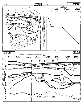
[00186] The example shown in Figure 16 demonstrates a set of 2D/3D
views of a vertically
georeferenced raster image. The "2D Section" view shows the images with the
defined vertical
domain and Z range. The "2D Map" view shows the defined surface (XY) location
for the raster
image. The "3D" view shows the georeferenced raster image in a three
dimensional space.
[00187] Vertically georeferenced raster images (e.g., the image-painted
folded rectangles
described variously above) may provide a niechanism for integrating seismic
section data from
geologic ideas, scanned drawings/images or other data sources into a 2D/3D
viewer. These data may
be integrated with other information to help guide geologic or geophysical
interpretation of the
earth's subsurface.
21
CA 02753946 2011-08-26
WO 2010/102097PCT/US2010/026193
[ints
uai me
vertically georeferenced raster images maintain spatial relationships with
other
data types allowing geoscience interpreters to better understand the
subsurface.
[00189] The
various labels used herein -- such as II, 12, WI and W2 -- are not meant of
themselves to imply special significance for the things they label. Rather,
they are intended as a
means distinguishing different things. For example, the labels "II" and "12"
imply that image I is
not the same as image 12.
[00190] Any two
or more of the embodiments described herein may be combined to form a
more complex embodiment.
[00191] Although
the embodiments above have been described in considerable detail,
numerous variations and modifications will become apparent to those skilled in
the art once the
above disclosure is fully appreciated. It is intended that the following
claims be interpreted to
embrace all such variations and modifications.
22